
Extra Tropical Cyclones
Enroll to start learning
You’ve not yet enrolled in this course. Please enroll for free to listen to audio lessons, classroom podcasts and take practice test.
Interactive Audio Lesson
Listen to a student-teacher conversation explaining the topic in a relatable way.
Understanding Extra Tropical Cyclones
🔒 Unlock Audio Lesson
Sign up and enroll to listen to this audio lesson

Today we’re diving into extra tropical cyclones. Can anyone tell me what they are?

Are they the same as tropical cyclones?
Good question! Extra tropical cyclones form at mid to high latitudes and have distinct frontal systems. Why do you think the differences in latitude matter?

Because the temperature difference between air masses is greater there?
Exactly! The interplay of warm and cold air creates dynamic weather patterns. Remember—extra tropical cyclones are linked to the polar front.

So they have a warm front and a cold front?
Yes, and this leads to various weather conditions including precipitation. Let's keep going!
Lifecycle of Extra Tropical Cyclones
🔒 Unlock Audio Lesson
Sign up and enroll to listen to this audio lesson

Now, let’s discuss the lifecycle of an extra tropical cyclone. What happens when the pressure drops along the polar front?

Does the warm air move north and the cold air south?
Correct! This motion creates an anticlockwise circulation. Can anyone describe what happens when the cold front overtakes the warm front?
The warm air gets completely lifted up, right? That’s how the cyclone dissipates?
Right again! This is called occlusion, leading to the eventual dissipation of the cyclone. Remember, it’s all about the interaction between these air masses.
Comparison with Tropical Cyclones
🔒 Unlock Audio Lesson
Sign up and enroll to listen to this audio lesson
Who can explain how extra tropical cyclones differ from tropical cyclones?
Tropical cyclones only happen over oceans, while extra tropical can form over land and have frontal systems.
Exactly! And remember, tropical cyclones typically have higher wind speeds. Why do we think that’s important?
Because higher wind speeds can cause more destruction?
That’s correct! Understanding these differences helps us predict their impact on weather systems.
Introduction & Overview
Read summaries of the section's main ideas at different levels of detail.
Quick Overview
Standard
This section focuses on extra tropical cyclones, which develop at mid to high latitudes. They are characterized by the interactions between warm southern air and cold northern air along the polar front. The text explores the lifecycle of these cyclones, their structure, how they differ from tropical cyclones, and their overall impact on weather systems.
Detailed
Extra Tropical Cyclones
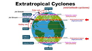
Extra tropical cyclones occur in the mid and high latitudes beyond the tropics. They develop along the polar front and are influenced by the dynamics of differing air masses. Initially, the front remains stationary until a drop in pressure prompts warm air from the south to move northwards and cold air from the north to move southwards, creating an anticlockwise cyclonic circulation in the Northern Hemisphere.
Key Features
- Structure: An extra tropical cyclone features both a warm front and a cold front, with warm air wedged between colder air sectors, leading to various precipitation forms as the warm air rises.
- Lifecycle: The cold front typically moves faster than the warm front, overtaking it, leading to occlusion where warm air is completely lifted above the surface, resulting in the dissipation of the cyclone.
- Differences from Tropical Cyclones: While tropical cyclones form solely over warm oceans and have no pronounced frontal systems, extra tropical cyclones can develop over land or sea and possess a unique frontal structure. Tropical cyclones, marked by higher wind speeds and destruction, move from east to west, contrasting with the west-east movement of extra tropical cyclones.
These phenomena significantly affect weather patterns across vast areas, highlighting the importance of understanding their dynamics.
Youtube Videos


Audio Book
Dive deep into the subject with an immersive audiobook experience.
Definition of Extra Tropical Cyclones
Chapter 1 of 5
🔒 Unlock Audio Chapter
Sign up and enroll to access the full audio experience
Chapter Content
The systems developing in the mid and high latitude, beyond the tropics are called the middle latitude or extra tropical cyclones. The passage of front causes abrupt changes in the weather conditions over the area in the middle and high latitudes.
Detailed Explanation
Extra tropical cyclones are weather systems that form in regions that are not tropical, particularly in the mid to high latitudes. They are characterized by their association with fronts, which are boundaries between different air masses. These fronts cause sudden changes in weather, which can include shifts in temperature, precipitation, and wind patterns. This means that when a front passes through an area, residents may experience a rapid change in the weather conditions.
Examples & Analogies
Imagine a line drawn in the sand on a beach separating two different areas: one side is sunny and warm, and the other side is cloudy and chilly. When the tide comes in, it washes over that line and suddenly changes the weather. This is similar to how a front can change the weather in a location very quickly.
Formation of Extra Tropical Cyclones
Chapter 2 of 5
🔒 Unlock Audio Chapter
Sign up and enroll to access the full audio experience
Chapter Content
Extra tropical cyclones form along the polar front. Initially, the front is stationary. In the northern hemisphere, warm air blows from the south and cold air from the north of the front. When the pressure drops along the front, the warm air moves northwards and the cold air moves towards south setting in motion an anticlockwise cyclonic circulation.
Detailed Explanation
Extra tropical cyclones typically develop along what is known as the polar front, which is a boundary between cold polar air and warm tropical air. Initially, this front doesn’t move much. However, when there is a change in pressure, the warm air rises and moves north while the cold air moves south. This shifting of air creates a cyclonic circulation, which spins in an anticlockwise direction in the northern hemisphere. This spinning motion of air is essential for the development of the cyclone.
Examples & Analogies
Think of it as a dance in which one partner (the warm air) spins away from the other partner (the cold air). As they dance, they create a whirlwind effect, which, instead of being chaotic, leads to a structured movement known as the cyclone.
Structure of a Well-Developed Cyclone
Chapter 3 of 5
🔒 Unlock Audio Chapter
Sign up and enroll to access the full audio experience
Chapter Content
The cyclonic circulation leads to a well developed extra tropical cyclone, with a warm front and a cold front. The plan and cross section of a well developed cyclone is given in Figure 9.9.
Detailed Explanation
In a mature extra tropical cyclone, there are two distinct fronts: the warm front and the cold front. The warm front is where warm air rises over the cold air, leading to gentle weather changes and precipitation. In contrast, the cold front involves the cold air pushing into the warmer air, resulting in more intense weather events, including thunderstorms and heavier precipitation. The interaction between these two air masses is what defines the structure of the cyclone, with a warm sector of air trapped between them.
Examples & Analogies
Imagine two glasses of water at different temperatures: one is hot and one is cold. When you pour the hot water into the cold glass, the hot water rises while the cold water sinks, creating swirling patterns. This interaction mimics how warm and cold fronts interact in a cyclone, leading to various weather phenomena.
The Life Cycle of an Extra Tropical Cyclone
Chapter 4 of 5
🔒 Unlock Audio Chapter
Sign up and enroll to access the full audio experience
Chapter Content
As a result, cumulus clouds develop along the cold front. The cold front moves faster than the warm front ultimately overtaking the warm front. The warm air is completely lifted up and the front is occluded and the cyclone dissipates.
Detailed Explanation
As the extra tropical cyclone evolves, cumulus clouds form along the cold front, which typically moves faster than the warm front. Eventually, the cold front overtakes the warm front. This process is called occlusion. Once occlusion occurs, the warm air gets pushed up completely, and this often leads to a dissipation of the cyclone. Essentially, the system uses up its energy and can no longer sustain itself.
Examples & Analogies
Imagine blowing up a balloon. Initially, the air creates a lot of pressure and the balloon expands. But if you keep blowing and blow too much air, the balloon can burst. The same principle applies to a cyclone—once the energy is exhausted, it dissipates.
Differences between Extra Tropical and Tropical Cyclones
Chapter 5 of 5
🔒 Unlock Audio Chapter
Sign up and enroll to access the full audio experience
Chapter Content
The extra tropical cyclone differs from the tropical cyclone in number of ways. The extra tropical cyclones have a clear frontal system which is not present in the tropical cyclones. They cover a larger area and can originate over the land and sea.
Detailed Explanation
Extra tropical cyclones and tropical cyclones have several key differences. Extra tropical cyclones typically have a defined frontal system, which contributes to their structure and weather effects. They can develop over both land and oceans, and they generally impact larger areas. In contrast, tropical cyclones develop only over warm ocean waters and do not have a clear frontal boundary. Additionally, the destructive power of tropical cyclones is often greater than that of extra tropical cyclones due to their intense wind speeds and potential for damage.
Examples & Analogies
Think of an extra tropical cyclone as a large concert that includes several performers (the fronts) putting on a show together, affecting a big audience. In contrast, a tropical cyclone is like a single rock concert that draws an enormous crowd, but it’s happening in a specific place and creates very intense excitement (or damage) only in that area.
Key Concepts
-
Polar Front: The boundary where cold northern air meets warm southern air, leading to cyclone formation.
-
Cyclonic Circulation: The motion of air around a low-pressure system, which is anticlockwise in the Northern Hemisphere.
-
Lifecycle of a Cyclone: The stages of development, intensification, and dissipation of a cyclone, influenced by air mass interactions.
Examples & Applications
Examples of extra tropical cyclones can be seen during winter storms across Europe and North America, where cold fronts interact with warm air from the south.
An example of the effects of extra tropical cyclones includes severe storms in the North Atlantic, which lead to heavy rain and powerful winds.
Memory Aids
Interactive tools to help you remember key concepts
Rhymes
Cyclones twist and whirl around, in winter's chill, they are found.
Stories
Imagine two friends, Warmy and Coldy, meeting at the park gate (the polar front). They start to mix and dance (cyclic motion) causing waves to emerge (storms).
Memory Tools
A acronym for the cyclone cycle: 'F-D-D-O', which stands for Formation, Development, Dissipation, Occlusion.
Acronyms
FROST - Frontal system, Rotation, Over land and sea, Stormy weather, Transition zone.
Flash Cards
Glossary
- Extra Tropical Cyclone
A weather system that develops in mid and high latitudes characterized by frontal systems.
- Frontal System
The boundary zone between two differing air masses that can generate strong winds and precipitation.
- Occlusion
A process in which a cold front overtakes a warm front, leading to the lifting of warm air and the dissipation of the cyclone.
Reference links
Supplementary resources to enhance your learning experience.