
Improving Estimation of Specific Yield
Enroll to start learning
You’ve not yet enrolled in this course. Please enroll for free to listen to audio lessons, classroom podcasts and take practice test.
Interactive Audio Lesson
Listen to a student-teacher conversation explaining the topic in a relatable way.
Integrating Multiple Methods
🔒 Unlock Audio Lesson
Sign up and enroll to listen to this audio lesson

To improve our estimation of specific yield, we should integrate multiple methods. Can anyone think of what those methods might be?

Maybe we could use both lab tests and field tests?
Exactly, Student_1! Using both laboratory and field methods, like gravimetric and pumping tests, can give us a more accurate and comprehensive picture. Using a mnemonic, think 'LAB+FIELD' to remember this integration.

What specific lab methods can we use?
Great question! We can use the gravimetric method and the centrifuge method to measure the specific yield more accurately.

So, what’s the central idea here?
The key point is that by combining lab and field data, we reduce the inaccuracies that might arise from using a single approach. This mixture increases our confidence in the estimation of specific yield.
Incorporating Technology
🔒 Unlock Audio Lesson
Sign up and enroll to listen to this audio lesson

Let’s talk about technology. How can remote sensing help us improve estimation?
Could it give us more accurate large-scale data?
Absolutely, Student_3! Remote sensing can provide valuable data about groundwater levels over large areas. Remember the acronym 'GIS' which stands for Geographic Information System, a crucial tool in this technology.

And how do we apply this data?
We can combine this remote sensing data with field observations to calibrate our specific yield models effectively.
So, technology helps us gather and analyze data more efficiently?
Correct! The integration of technology plays a vital role in obtaining accurate groundwater modeling data.
Importance of Long-term Monitoring
🔒 Unlock Audio Lesson
Sign up and enroll to listen to this audio lesson
Why do you think long-term monitoring is essential for estimating specific yield?
It might show how specific yield can change over seasons, right?
Exactly, Student_2! Seasonal variability can affect ground and water levels, thereby influencing specific yield. Let’s use the acronym 'SEASON' to remember this concept: Seasonal Effects on Aquifer Saturation and Output Needs.
So we really need to keep an eye on these factors over time?
Yes! Continuous monitoring allows us to adapt our water management strategies effectively.
Summary and Key Takeaways
🔒 Unlock Audio Lesson
Sign up and enroll to listen to this audio lesson
To summarize, what are the key strategies we've discussed to improve the estimation of specific yield?
We talked about using multiple methods, right?
And incorporating technology like remote sensing and GIS!
And long-term monitoring to capture variability!
Exactly! All these aspects work together to help us better estimate specific yield, making our groundwater resource management more sustainable. Remember the acronym 'IMPROVE' for Integrate, Monitor, Utilize, Relate, Optimize, Validate, and Enhance in managing specific yield!
Introduction & Overview
Read summaries of the section's main ideas at different levels of detail.
Quick Overview
Standard
Improving the estimation of specific yield is essential for accurate groundwater resource management. This section highlights the necessity of employing multiple methods, integrating remote sensing and GIS, and utilizing numerical models for refined estimation, as well as the importance of long-term monitoring to capture seasonal variations.
Detailed
Improving Estimation of Specific Yield
Understanding specific yield is critical in groundwater hydrology for effective resource management. This section outlines several strategies to enhance the accuracy in estimating specific yield (Sy). These include integrating different methodologies such as laboratory and field techniques, incorporating modern technologies like remote sensing and Geographic Information Systems (GIS) for large-scale estimations, and employing numerical modeling to simulate and calibrate specific yield based on observed data. Moreover, the necessity of conducting long-term monitoring is emphasized to capture seasonal variability, which can significantly affect the estimation of specific yield.
Youtube Videos


Audio Book
Dive deep into the subject with an immersive audiobook experience.
Using Multiple Methods for Accuracy
Chapter 1 of 4
🔒 Unlock Audio Chapter
Sign up and enroll to access the full audio experience
Chapter Content
- Use multiple methods (lab + field) for better accuracy.
Detailed Explanation
This chunk emphasizes the importance of employing a combination of laboratory and field methods to improve the accuracy of specific yield estimations. Laboratory methods involve controlled experiments where soil samples are tested in a lab setting, while field methods include actual testing on the aquifer through methods like pumping tests. By using both methods, the strengths of each can compensate for their weaknesses, leading to more reliable results.
Examples & Analogies
Think of it like cooking a recipe where you taste the dish at different steps. If you only rely on the initial ingredients' measurements, you might not get the best flavor. But by tasting and adjusting (like using different testing methods), you can perfect the dish.
Incorporating Remote Sensing and GIS
Chapter 2 of 4
🔒 Unlock Audio Chapter
Sign up and enroll to access the full audio experience
Chapter Content
- Incorporate remote sensing and GIS for large-scale estimation.
Detailed Explanation
This chunk discusses the utilization of remote sensing technology and Geographic Information Systems (GIS) to estimate specific yield over large areas. Remote sensing involves gathering data from satellites or aerial sources, which can help identify surface and subsurface water characteristics efficiently. GIS helps in analyzing this data spatially, providing insights and creating models that can represent the distribution of specific yield across various geographical settings.
Examples & Analogies
Imagine using Google Maps to find the quickest route to a destination instead of relying solely on a written directions. GIS functions similarly by providing spatial context that aids in understanding and making decisions about groundwater resources.
Employing Numerical Modeling
Chapter 3 of 4
🔒 Unlock Audio Chapter
Sign up and enroll to access the full audio experience
Chapter Content
- Employ numerical modeling to simulate and calibrate Sy using observed data.
Detailed Explanation
This chunk illustrates the use of numerical modeling as a tool to simulate groundwater behavior and improve specific yield estimates. Numerical models use mathematical representations based on scientific principles to predict how water moves in aquifers. By calibrating these models with actual observed data from aquifer tests, scientists can refine their estimates of specific yield, making them more accurate and applicable to real-world situations.
Examples & Analogies
Think of numerical modeling like a weather forecast. Meteorologists use models to predict weather patterns based on past data and current observations. Just as they calibrate their models to improve accuracy, hydrogeologists do the same for estimating specific yield, constantly adjusting their predictions based on new data.
Long-Term Monitoring for Variability
Chapter 4 of 4
🔒 Unlock Audio Chapter
Sign up and enroll to access the full audio experience
Chapter Content
- Conduct long-term monitoring to observe seasonal variability.
Detailed Explanation
The final chunk highlights the necessity of conducting long-term monitoring of groundwater levels and specific yield, as these can vary significantly with seasonal changes, rainfall, and other environmental factors. By collecting data over an extended period, researchers can identify trends and patterns that reflect changes in specific yield due to different seasons or climatic conditions, which aids in effective water resource management.
Examples & Analogies
Consider a gardener who watches how plants grow in different seasons. By tracking their growth throughout the year, the gardener understands when to water and fertilize best. Similarly, monitoring groundwater over time helps determine the best practices for managing water resources effectively.
Key Concepts
-
Integration of multiple estimation methods: Using both laboratory and field methods improves the accuracy of specific yield estimation.
-
Remote Sensing and GIS: These technologies enhance large-scale data collection and analysis for groundwater studies.
-
Numerical Modeling: This approach simulates and calibrates specific yield based on observed data for increased accuracy.
-
Long-term Monitoring: Ongoing observation of groundwater levels is essential to track seasonal variability and modify management practices.
Examples & Applications
If a field team measures specific yield using both gravity drainage tests and pumping tests, they likely get more reliable data compared to only using one method.
Utilizing satellite imagery to track groundwater levels over large agricultural areas can help identify regions with excessive water withdrawal.
Memory Aids
Interactive tools to help you remember key concepts
Rhymes
To gauge specific yield with some thrill, combine methods to get a clear drill.
Stories
Imagine a wise old farmer who uses both rain gauges (field method) and special tools (lab method) to know how much water his crops need, season by season. This careful approach ensures he never over or under waters his fields.
Memory Tools
Use the mnemonic 'IMPROVE' - Integrate, Monitor, Utilize, Relate, Optimize, Validate, and Enhance to remember key strategies for specific yield estimation.
Acronyms
Remember 'GIS' for Geographic Information Systems to recall how technology aids in groundwater research.
Flash Cards
Glossary
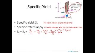
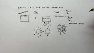
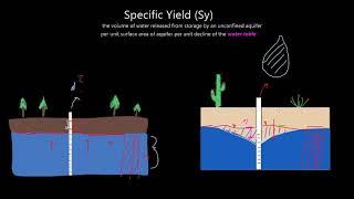
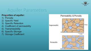
- Specific Yield (Sy)
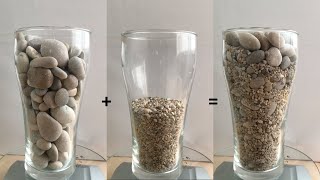
The ratio of the volume of water that drains from the saturated soil or rock due to gravity to the total volume of the soil or rock mass.
- Remote Sensing
The acquisition of information about an object or phenomenon without making physical contact, often used to gather data over large areas.
- Geographic Information System (GIS)
An organized system for collecting, storing, and analyzing geographical data, used to create maps and analyze spatial relationships.
- Numerical Modeling
A mathematical modeling approach that uses computational algorithms to simulate and analyze complex processes, such as groundwater movement.
- Longterm Monitoring
An ongoing process of observing and recording data over extended periods to detect changes and trends.
Reference links
Supplementary resources to enhance your learning experience.