
Maritime Routes: Indian Ocean and Beyond
Enroll to start learning
You’ve not yet enrolled in this course. Please enroll for free to listen to audio lessons, classroom podcasts and take practice test.
Interactive Audio Lesson
Listen to a student-teacher conversation explaining the topic in a relatable way.
Introduction to Maritime Routes
🔒 Unlock Audio Lesson
Sign up and enroll to listen to this audio lesson

Today, we are going to talk about maritime routes, specifically how they connected various regions like East Africa, South Asia, and China. Can anyone tell me why maritime routes were crucial during this period?

They allowed for trade between different cultures.
Exactly! These routes facilitated not just trade but also cultural exchanges. They were greatly influenced by the monsoon wind patterns, which helped sailors plan their journeys. Can anyone explain how these wind patterns worked?

The monsoon winds changed direction, which made sailing predictable at certain times of the year.
Good! This predictability was crucial for planning trade expeditions.

What types of goods were transported?
Great question! Goods like silk, ceramics, and spices were transported across these routes. Now let's move on to the innovations that helped navigate these waters.
Innovations in Navigation
🔒 Unlock Audio Lesson
Sign up and enroll to listen to this audio lesson

Can someone name a few navigational tools that were essential for maritime trade?

The astrolabe and compass!
Correct! The astrolabe helped sailors determine their latitude while the compass allowed them to navigate more accurately. How do you think these tools changed trade?
They made it safer and faster!
Exactly! This led to increased trade activities and connections among distant regions.
What kinds of boats were used?
Good follow-up! Chinese junks and Arab dhows were commonly used for their designs suited to carrying large cargo. Now let's discuss the cultural exchanges that resulted.
Cultural Diffusion
🔒 Unlock Audio Lesson
Sign up and enroll to listen to this audio lesson
How did trade along these maritime routes lead to cultural exchanges?
Different cultures interacted, sharing ideas and traditions.
Exactly! For example, Islamic merchants introduced Islam to regions in Southeast Asia and East Africa. Can you think of examples of cultural merging?
The Swahili culture, which mixes Bantu and Arab influences!
Yes! The Swahili civilization is a perfect example of how trade created unique blends of culture. Let's summarize what we’ve learned today.
Summarizing Key Concepts
🔒 Unlock Audio Lesson
Sign up and enroll to listen to this audio lesson
To wrap up our discussion, what are the main points we covered about maritime routes?
They were important for trade and were influenced by monsoon winds.
Innovations like the astrolabe and compass improved navigation.
They also facilitated cultural exchanges between regions.
Excellent summaries everyone! This interconnectedness of trade and culture has laid the foundations for a globalized world.
Introduction & Overview
Read summaries of the section's main ideas at different levels of detail.
Quick Overview
Standard
This section explores the importance of maritime routes during the medieval period, highlighting how monsoon wind patterns allowed for predictable trading and how technological advancements like the compass and astrolabe played key roles in navigation. It emphasizes the cultural diffusion that occurred as Islamic merchants connected various regions and the resulting unique civilizations that emerged in places like East Africa.
Detailed
Detailed Summary
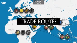
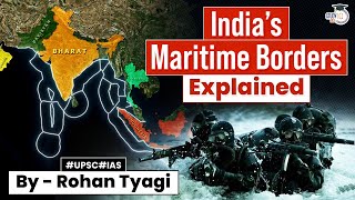
Maritime routes, while not categorized under the famed Silk Road, formed crucial avenues of trade and cultural exchange among East Africa, South Asia, Southeast Asia, and China during the medieval period. These routes took advantage of the monsoon wind patterns, allowing for predictable sailing schedules between regions, which was essential for the trading economy.
Innovations in Navigation
Innovative navigational tools such as astrolabes and improved compass designs enabled merchants to traverse long distances by sea more safely and efficiently. Chinese junks were instrumental in transporting bulk goods like ceramics and silk, while Arab dhows carried commodities such as dates and frankincense.
Cultural Diffusion and Exchange
The interactions facilitated by these maritime routes led to significant cultural diffusion. Islamic merchants, particularly in ports like Kilwa, Mombasa, and Malacca, introduced Islam to Southeast Asia and East Africa. In return, this exchange enriched East African cultures, producing a distinct Swahili civilization characterized by a blend of Bantu, Arabic, and Persian elements. The connections fostered by these routes not only led to economic prosperity but also encouraged a vibrant tapestry of cultural interactions across these regions.
Youtube Videos


Audio Book
Dive deep into the subject with an immersive audiobook experience.
Overview of Maritime Routes
Chapter 1 of 3
🔒 Unlock Audio Chapter
Sign up and enroll to access the full audio experience
Chapter Content
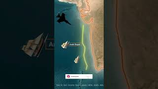
Although not part of the “Silk Road” name, maritime routes connected East Africa, South Asia, Southeast Asia, and China. Monsoon wind patterns (between June and September, and October to February) allowed predictable sailing schedules.
Detailed Explanation
This chunk introduces the importance of maritime trade routes, which, despite not being labeled as part of the 'Silk Road,' were crucial for connecting various regions. The text highlights the geographical areas involved—East Africa, South Asia, Southeast Asia, and China. Key to this maritime trade was the monsoon wind patterns, which were seasonal winds that greatly influenced sailing schedules. Traders learned to navigate these predictable wind patterns, allowing them to plan their journeys more effectively and ensure timely arrivals.
Examples & Analogies
Think of the maritime routes as highways of the sea, similar to how we rely on GPS for accurate travel times today. Just like how a delivery service uses favorable traffic patterns to schedule deliveries at the right time, sailors used the monsoon winds to time their voyages across oceans.
Navigator Innovations
Chapter 2 of 3
🔒 Unlock Audio Chapter
Sign up and enroll to access the full audio experience
Chapter Content
Navigator Innovations: Astrolabes, compass use, and improved hull designs enabled merchants to travel long distances by sea. Chinese junks carried bulk goods (ceramics, silk), while Arab dhows transported dates, frankincense, and pearls.
Detailed Explanation
This chunk discusses various innovations in navigation and ship design that facilitated long-distance maritime trade. The astrolabe was a tool that helped determine latitude, while the compass provided directional guidance, both crucial for navigating the open sea. The hull designs of ships improved over time, enabling merchants to carry larger amounts of goods. Chinese junks, which were sturdy ships, were commonly used to transport heavy items like ceramics and silk, while Arab dhows, lighter and faster ships, were ideal for carrying goods like dates and pearls.
Examples & Analogies
Imagine being a sailor in ancient times, looking out at an endless ocean. The astrolabe is like a smartphone app that helps you know where you are, while the compass is akin to a navigation tool that always points you in the right direction. Without these inventions, traveling across the oceans would feel like driving through a thick fog without a map—very risky!
Cultural Diffusion Through Trade
Chapter 3 of 3
🔒 Unlock Audio Chapter
Sign up and enroll to access the full audio experience
Chapter Content
Cultural Diffusion: Islamic merchants in ports such as Kilwa, Mombasa, and Malacca introduced Islam to Southeast Asia and East Africa. In return, East African Swahili culture blended Bantu, Arab, and Persian influences, creating a unique coastal civilization.
Detailed Explanation
This chunk explains how maritime trade facilitated cultural exchanges, particularly the spread of Islam by merchants operating in various ports. Islamic traders brought their religion and customs to places like Kilwa and Mombasa in East Africa and contributed to the development of local cultures. The Swahili culture, which emerged in East Africa, was a blend of Bantu languages and traditions with Arab and Persian influences, showcasing how trading activities led to a rich and diverse cultural landscape.
Examples & Analogies
Think about how food trucks today merge different cuisines to create unique dishes. Just like a food truck might blend Mexican and Korean flavors, trade along these maritime routes mixed various cultures together, leading to something entirely new, the Swahili culture, created from the interactions of different people and their traditions.
Key Concepts
-
Maritime Routes: Important trade pathways connecting regions across the sea.
-
Monsoon Winds: Seasonal winds that allowed predictable sailing and trade timing.
-
Astrolabe: Navigational tool that enabled sailors to determine their latitude.
-
Cultural Diffusion: Exchange of cultural practices and ideas between regions.
Examples & Applications
The introduction of Islam in Southeast Asia through trade by Islamic merchants.
The blending of Bantu, Arab, and Persian influences in the Swahili civilization.
Memory Aids
Interactive tools to help you remember key concepts
Rhymes
Sailing the seas with the wind so fair, / Navigators find their way with astrolabe care.
Stories
Once, traders set sail across the Indian Ocean, guided by the winds that knew when to blow, carrying spices and silk, they shared their tales, creating a blend of cultures wherever they’d go.
Memory Tools
Remember 'MAP' for navigating maritime: Monsoon winds, Astrolabe, Ports.
Acronyms
CULTURE
*C*ultural diffusion
*U*nity of trade
*L*ocal interaction
*T*radition spread
*U*nique blends
*R*eligion exchange
*E*conomic ties.
Flash Cards
Glossary
- Maritime routes
Trade pathways established over oceans and seas, facilitating cultural and economic exchanges between regions.
- Monsoon winds
Seasonal winds in the Indian Ocean that drastically affect sailing routes and trade schedules.
- Astrolabe
An ancient instrument used for solving problems related to time and the position of the stars; essential for navigation.
- Dhow
A traditional Arab sailing vessel used for maritime trade, notable for its lateen sail.
- Cultural diffusion
The spread of cultural beliefs and social activities from one group to another, often through trade.
Reference links
Supplementary resources to enhance your learning experience.