
Accuracy and Measurement
Enroll to start learning
You’ve not yet enrolled in this course. Please enroll for free to listen to audio lessons, classroom podcasts and take practice test.
Interactive Audio Lesson
Listen to a student-teacher conversation explaining the topic in a relatable way.
Accuracy in Mapping
🔒 Unlock Audio Lesson
Sign up and enroll to listen to this audio lesson

Today we'll discuss how accuracy in mapping is calculated using the thickness of lines and the scale of the map. Can anyone tell me how we derive plotting accuracy?

Is it related to the thickness of the line, like how thick it is on the actual map?
Exactly! The formula is 0.25 mm multiplied by the scale of the map. For instance, at a 1:1200 scale, what's the maximum error we could expect?

That would be 30 cm, right? Because 0.25 times 1200 equals 300 mm.
Well done! So what does this mean for features smaller than 30 cm on this map?

They can't be represented accurately!
Correct! Accuracy is crucial, especially in engineering maps. Always remember the acronym 'MAP' for 'Max Allowable Precision.'
Survey Stations
🔒 Unlock Audio Lesson
Sign up and enroll to listen to this audio lesson

Let's move on to survey stations. Why do you think their location is so important?
They have to be visible from other stations, right?
Exactly! They should also cover both minimum and maximum elevations. Why do you think that's vital?

Because we need a clear view of the whole area to get accurate measurements?
Right! It's about ensuring horizontal and vertical control. Remember the term 'HV' - Horizontal and Vertical control. Can anyone tell me what happens if the angles between stations are not ideal?
It could lead to errors in the measurements!
Spot on! Always aim for acute angles between the stations, ideally between 30° and 120°.
Safety in Surveying
🔒 Unlock Audio Lesson
Sign up and enroll to listen to this audio lesson
Safety is key in surveying! Can you think of some hazards we face in the field?
Heavy machinery and poor visibility due to dust!
And wild animals, right? Like snakes.
Exactly, we need to be cautious! Always wear safety vests and keep a first aid kit handy. What does OSHA stand for?
Occupational Safety and Health Administration!
Great! And they provide valuable guidelines. When conditions are hazardous, what can we do to protect ourselves?
Carry fluids, wear hats, and maybe avoid going out in extreme weather?
Exactly! Always prioritize personal safety.
Introduction & Overview
Read summaries of the section's main ideas at different levels of detail.
Quick Overview
Standard
The section emphasizes the crucial role of accuracy in mapping through the calculation of allowable errors based on scale. It elaborates on survey stations, their optimal positioning, and their function in horizontal and vertical control for mapping. It also explores the significance of safety measures in the field, outlines different units of measurement, and describes various types of measurement errors along with the difference between accuracy and precision.
Detailed
Detailed Summary
Accuracy in Mapping
Accuracy in mapping is assessed through the calculation of plotting accuracy, which is dependent on the thickness of lines on a map and the scale used. For example, using the formula: 0.25 mm x scale of mapping, we find that a 1:1200 scale allows for a maximum allowable error of 30 cm, meaning that features smaller than this cannot be represented on such a map.
Survey Stations
Survey stations are pivotal points along the boundary of a surveyed area, selected based on visibility from other stations and terrain coverage. They ensure horizontal (X, Y) and vertical (Z) control, helping define absolute positions concerning known points. Surveyors must ensure that angles between stations remain within acceptable limits to avoid observational errors.
Survey Lines
Survey lines connect survey stations, including a base line necessary for computational accuracy. They should be laid on level ground and shaped to cover significant areas effectively.
Safety in Surveying
Fieldwork in surveying can pose various hazards. To ensure safety, surveyors must use visible safety gear, follow OSHA guidelines, and remain vigilant about potential weather and wildlife-related risks.
Units of Measurement
Two systems of units prevail in surveying: the English and Metric (SI) systems. Understanding how to convert between these systems is imperative for civil engineers, as accurate measurements guide construction plans and operations.
Errors in Measurements
Errors in measurements often fall into systematic and random categories. This section highlights the necessity for precision and accuracy, explaining how to identify and mitigate errors in surveying practices.
Youtube Videos


Audio Book
Dive deep into the subject with an immersive audiobook experience.
Plotting Accuracy
Chapter 1 of 4
🔒 Unlock Audio Chapter
Sign up and enroll to access the full audio experience
Chapter Content
The plotting accuracy of a map can be determined with a simple concept. Cartographically, any line on a map is drawn with a thickness of 0.25 mm, which is considered to be the least dimension of a smallest dot. It means the thickness of the line or dot on the ground can be computed by multiplying the least dimension of 0.25 mm with the scale of map.
Plotting accuracy = 0.25 mm x scale of mapping (1.1)
At 1:1,200 scale, the plotting accuracy will be 0.25 x 1200 = 300 mm = 30 cm. So, 30 cm is the maximum allowable error which could be presented in 1: 1,200 scale maps. A feature smaller than 30 cm on the ground can’t be theoretically shown on this map.
Detailed Explanation
Plotting accuracy refers to how accurately features on a map represent physical features in the real world. To determine plotting accuracy, we start with a standard thickness for lines and points, typically 0.25 mm. This thickness is considered the minimum size we can depict. By multiplying this thickness by the map's scale, we can determine the maximum error in representing real-world dimensions. For example, in a 1:1200 scale map, the plotting accuracy would be calculated as 0.25 mm times 1200, which equals 300 mm (30 cm). This means any physical feature smaller than 30 cm would not be accurately represented on this scale without distortion or omission.
Examples & Analogies
Think of it like trying to capture a small detail in a photograph. If you take a photo of a small object, but your camera settings don't allow for fine detail, then anything smaller than a certain size might just blur together or disappear entirely. Similarly, in mapping, if a feature is too small to be represented accurately at a given scale, it becomes invisible on the map.
Survey Stations
Chapter 2 of 4
🔒 Unlock Audio Chapter
Sign up and enroll to access the full audio experience
Chapter Content
To survey the boundary of an area, the stations taken along the boundary of an area as controlling points are known as survey stations. These stations are definite points on the Earth whose locations have been determined by surveying methods. Their location is marked on the ground over which survey instruments are kept to take the observations. Angular, linear, bearing and height observations may be taken at these stations, depending upon the purpose of survey. These stations are selected by the surveyors at commanding positions in an optimal manner, keeping in view the following criteria:
(i) Survey stations should be visible from at least two or more other survey stations.
(ii) As far as possible, survey stations must be situated so as to cover minimum elevation and maximum elevation of the area.
(iii) The criteria for selecting the survey stations is that lines joining them should not make obtuse angle (>120°) or acute angle (<30°) with each other.
(iv) Survey stations should be as few as possible, as more the stations more will be the observational work.
(v) Survey stations should be avoided at busy locations as it might affect the smooth measurement of survey observations.
Detailed Explanation
Survey stations are critical points used during mapping to ensure accuracy in measurements. They serve as reference points from which surveyors can take various measurements. The chosen locations for these stations must meet specific criteria for efficiency and visibility: they should be visible from other survey stations to allow for triangulation, positioned to capture the area's elevation changes, and spaced adequately apart to reduce excessive work. Additionally, survey stations should not be placed in busy areas where disturbance might occur, which could affect precise observations.
Examples & Analogies
Imagine trying to complete a jigsaw puzzle. The corner pieces serve as reference points for the entire puzzle. Similarly, survey stations act as reference points for surveying an area. If you place your corner pieces in easily visible and strategic locations, it makes it much easier to complete the puzzle accurately.
Purpose of Survey Stations
Chapter 3 of 4
🔒 Unlock Audio Chapter
Sign up and enroll to access the full audio experience
Chapter Content
The purpose of survey stations is to provide horizontal control (planimetry, X and Y) and vertical control (Z) during mapping work. In surveying, it is important to know the absolute position of a point/object with respect to a given origin, or its relative position with respect to a known point/object. The position information can be expressed as (X, Y and Z) in linear coordinate system or as (Ø, λ and Z) in polar coordinate system.
Detailed Explanation
Survey stations offer controls that are crucial for mapping. Horizontal control involves determining the X and Y coordinates of a location, while vertical control addresses the Z coordinate, which represents height above a reference point, usually sea level. Knowing these coordinates helps surveyors accurately place features on a map, ensuring they correspond to their real-world locations.
Examples & Analogies
Consider GPS navigation in a car. It uses a series of satellites (analogous to survey stations) to provide accurate location data in terms of latitude and longitude (similar to X and Y coordinates). Just like GPS helps you navigate accurately by fixing your position against known benchmarks, survey stations provide crucial data to map out land accurately.
Horizontal and Vertical Control
Chapter 4 of 4
🔒 Unlock Audio Chapter
Sign up and enroll to access the full audio experience
Chapter Content
The horizontal control is provided by two or more stations on the ground which are precisely fixed in position by distance and direction. It provides the basis for controlling the scale of the surveyed map as well as locating the various topographic features present in the area. The most common methods used to locate a point/feature in the field are by measuring: one angle and the adjacent distance, or two distances, or two angles. For small areas, horizontal control for topographic work is usually established by a traverse, but sometimes for a very small area mapping, two survey stations making a single line may also be used. Vertical control is provided by the Bench Marks (BMs) in or near the area to be surveyed.
Detailed Explanation
Horizontal control involves determining the position of points on a map through fixed reference stations, helping in accurate placement of topographic features like roads and buildings. Surveyors often employ triangulation methods—like measuring angles or distances—to establish these positions. Vertical control, on the other hand, helps ensure that elevation is correctly represented on the map, using benchmarks as reference points for measuring height.
Examples & Analogies
Think of building a skyscraper; it needs a solid foundation (horizontal control) and it must accurately measure up to specific heights (vertical control). Just like a construction team must ensure their building aligns correctly with the ground and rises to the right elevation, surveyors need reliable reference points to ensure accurate mapping.
Key Concepts
-
Plotting Accuracy: Calculated as the thickness of a line times the map's scale.
-
Survey Stations: Key points for measurements, crucial for determining horizontal and vertical control.
-
Safety in Surveying: Importance of following safety procedures to mitigate risks.
-
Units of Measurement: Distinctions between the English and Metric systems in surveying.
-
Errors in Measurement: Different types of errors that affect measurement accuracy.
Examples & Applications
In a 1:1200 scale map, the plotting accuracy is computed to be 30 cm, limiting the ability to accurately represent features smaller than this.
Survey stations must be visible to at least two others to ensure a triangulated measurement approach for improved accuracy.
Memory Aids
Interactive tools to help you remember key concepts
Rhymes
Plotting tech, with lines so fine, 0.25 mm makes it align!
Stories
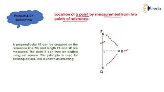
In a village, four friends named PQRS worked together on a map, ensuring they were all able to see each other to make accurate measurements. They learned that if one got lost, the map would falter!
Memory Tools
Remember 'SHAPE' for Survey Stations: Visibility, Height, Angles, Precise positioning, Error minimization.
Acronyms
MAP - Max Allowable Precision regarding accuracy in maps.
Flash Cards
Glossary
- Plotting Accuracy
The maximum allowable error in mapping, calculated as the thickness of the line multiplied by the scale of the map.
- Survey Station
A point established on the ground from which measurements are taken in surveying.
- Horizontal Control
The position of points on a 2D plane expressed in coordinates (X, Y).
- Vertical Control
The elevation of points in relation to a fixed datum (Z).
- Systematic Errors
Errors that can be identified and corrected based on consistent patterns.
- Random Errors
Errors caused by unpredictable variations that cannot be consistently identified.
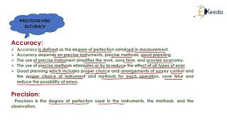
- Accuracy
The closeness of a measured value to the true value.
- Precision
The degree of consistency among repeated measurements.
Reference links
Supplementary resources to enhance your learning experience.