
Tacheometry
Enroll to start learning
You’ve not yet enrolled in this course. Please enroll for free to listen to audio lessons, classroom podcasts and take practice test.
Interactive Audio Lesson
Listen to a student-teacher conversation explaining the topic in a relatable way.
Introduction to Tacheometry
🔒 Unlock Audio Lesson
Sign up and enroll to listen to this audio lesson

Today we're diving into tacheometry, a fascinating method of measuring distances using angular observations. Can anyone tell me what a tacheometer is?

Isn't it a type of theodolite used for surveying?
Exactly! It's a device that helps us determine horizontal and vertical distances. Why do you think tacheometry is preferred in rough terrains?

I think it's because it's quicker and more accurate than using tape?
Correct! It's much more efficient where leveling is tedious. Remember this for our upcoming fieldwork!
Instruments Used in Tacheometry
🔒 Unlock Audio Lesson
Sign up and enroll to listen to this audio lesson

Let's focus on the instruments involved in tacheometry. What are the two main tools we use?

A tacheometer and a leveling rod?
That's right! The tacheometer has a special diaphragm called stadia hairs. Can anyone tell me how these hairs help us?

They allow us to measure the staff intercept, which is vital for calculating distances.
Great job! Remember, these instruments work together to provide accurate readings with reduced calculation efforts.
Methods of Measurement
🔒 Unlock Audio Lesson
Sign up and enroll to listen to this audio lesson
Now, let's delve into the methods used in tacheometry. Who can explain what we do when we have a horizontal line of sight?
We multiply the staff intercept by the constant K and then add the additive constant C.
Exactly! And what's the typical value of K?
It's usually 100.
Correct! Now, what happens when the line of sight is inclined?
We measure the vertical angle and use trigonometry to determine the distances.
Perfect! Here is a tip: remember 'D = K * S + C' for horizontal readings, it will help you in calculations.
Applications of Tacheometry
🔒 Unlock Audio Lesson
Sign up and enroll to listen to this audio lesson
Let's talk about where tacheometry is applied. Can anyone mention some of its uses?
It's used for traversing and contouring, right?
Yes! It's instrumental in geometrically complex areas, like steep terrains. How does this benefit surveyors?
It makes the process faster and reduces the number of errors.
Exactly! Efficiency is key in our field, and tacheometry is extremely beneficial.
Introduction & Overview
Read summaries of the section's main ideas at different levels of detail.
Quick Overview
Standard
This section covers the fundamentals of tacheometry, an efficient method to measure horizontal and vertical distances using angular readings with a tacheometer. It discusses the instruments involved, methods of measurement in various conditions, and the significance of tacheometry in surveying applications.
Detailed
Tacheometry
Tacheometry is a surveying technique used to determine horizontal and vertical distances through angular observations with a tacheometer. This method is preferred when traditional distance measuring techniques like chaining/taping prove inaccurate or inefficient, especially in rugged terrains or water-logged areas. Tacheometry excels in various applications, particularly in traversing and contouring.
1. Instruments Used
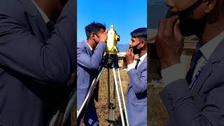
The primary instruments employed in tacheometry include a tacheometer and a leveling rod. A tacheometer is essentially a transit theodolite equipped with a specialized diaphragm, known as stadia hairs. This diaphragm contains three horizontal hairs: top, middle, and bottom, which are crucial for taking measurements. The tacheometer utilizes an anallactic lens to ensure accurate readings, with specific values for the multiplying constant (K = 100) and the additive constant (C = 0), simplifying calculations.
2. Methods of Tacheometry
Measurements can be taken in two cases:
-
Case I: Horizontal Line of Sight
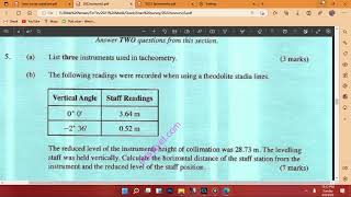
When the line of sight is horizontal, the horizontal distance (D) is calculated using the equation:
D = K * S + C,
where K is generally 100, S is the staff intercept, and C is usually zero. -
Case II: Inclined Line of Sight
If the ground is uneven and allows only inclined sights, vertical angles are also measured alongside the staff readings to determine horizontal distances using trigonometric methods.
3. Key Takeaway
Tacheometry provides an efficient means of collecting distance information, particularly in challenging landscapes, enhancing the speed and accuracy of surveying tasks.
Youtube Videos


Audio Book
Dive deep into the subject with an immersive audiobook experience.
Overview of Tacheometry
Chapter 1 of 5
🔒 Unlock Audio Chapter
Sign up and enroll to access the full audio experience
Chapter Content
In tacheometry, horizontal and vertical distances are determined by angular observations with a tacheometer. Tacheometry is more accurate than the chaining/taping, and more rapid in rough and difficult terrain where levelling is tedious and measuring distance by chaining/taping is not only inaccurate but slow and laborious. It is a best suited method when taking observations for steep and undulating/broken ground, river, water or swampy areas. Tacheometry is preferably used for traversing, but it is also used for contouring.
Detailed Explanation
Tacheometry is a surveying method used to measure distances using angles and an instrument known as a tacheometer. It’s more accurate than traditional methods like chaining or taping, especially in challenging environments like steep hills or marshy areas where measuring distances can be difficult and time-consuming. This method is particularly useful for mapping and traversing landscapes that are uneven or difficult to walk on.
Examples & Analogies
Imagine you are hiking in a mountainous area where the ground is uneven. If you tried to measure distances by walking with a tape, it would take a lot of time and effort. Instead, using a tacheometer allows you to quickly and accurately measure how far away different points are without needing to walk to them directly, much like using a pair of binoculars to look at landmarks in the distance.
Instruments Used
Chapter 2 of 5
🔒 Unlock Audio Chapter
Sign up and enroll to access the full audio experience
Chapter Content
The main instruments used in tacheometry are a tacheometer and a levelling rod. A tacheometer is a transit theodolite where the telescope is fitted with a special diaphragm, called stadia hairs, i.e., a diaphragm fitted with three horizontal hairs; one at the top, another in the middle and the third at the bottom of the diaphragm. These horizontal hairs are equidistant from the central one. The types of stadia diaphragm commonly used in tacheometers are shown in Figure 1.46. The term tacheometer is restricted to a transit theodolite which is provided with an anallactic lens in the telescope. The essential characteristics of a tacheometer are that the value of the multiplying constant (K= f / I) should be 100 and additive constant (C= f + d) should be zero. Levelling rod used is similar to those used in levelling work. To make the value of the additive constant zero, an additional convex lens, known as anallatic lens, is provided in the telescope. By having K=100 and C=0, the calculation work is considerably reduced.
Detailed Explanation
Two main instruments are used in tacheometry: the tacheometer and the levelling rod. The tacheometer has a special setup that includes a telescope with stadia hairs to assist in measuring distances. The apparatus is designed to ensure that the calculations for distances are simplified through two constants: K (which is generally set to 100) and C (which should ideally be zero) to make calculations quicker and more efficient. The levelling rod helps to determine the height differences.
Examples & Analogies
Think of the tacheometer as a high-tech camera for surveyors. Just like a camera lens has different parts to focus on and capture sharp images, the tacheometer has stadia hairs and anallatic lenses that help surveyors focus on measuring distances with precision. The levelling rod is like a ruler that gives the surveyor the height reference needed to understand elevation.
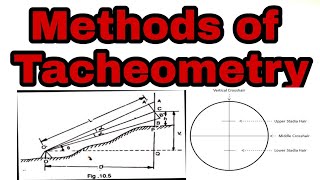
Methods of Tacheometry
Chapter 3 of 5
🔒 Unlock Audio Chapter
Sign up and enroll to access the full audio experience
Chapter Content
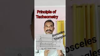
The principle used in tacheometry is that the horizontal distance between an instrument station and a point where the levelling rod is kept can be determined with the staff intercept (difference of top reading and bottom reading). For determining the horizontal distance between two points, a tacheometer is kept at one point and levelling staff is kept at another, and stadia readings on the levelling staff are read.
Detailed Explanation
The main method in tacheometry involves measuring the difference in readings on the staff at two points – the top reading and the bottom reading – which provides what is called the staff intercept. When this intercept is multiplied by the multiplying constant (K) and then adjusted by any additive constant (C), the horizontal distance between the tacheometer and the levelling rod can be calculated. This allows surveyors to determine measurements without having to travel the horizontal distance directly.
Examples & Analogies
Picture a game of tennis. Instead of running back and forth to measure how far you've hit the ball (which would take time and energy), you can stand at one spot and observe where your ball lands through a special pair of glasses that measure the distance without making you move. This observation lets you quickly gather important information about how far you've played.
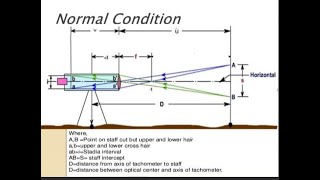
Case I - Horizontal Line of Sight
Chapter 4 of 5
🔒 Unlock Audio Chapter
Sign up and enroll to access the full audio experience
Chapter Content
In a simplified form, the above equation for horizontal distance (D) can be written as D = K S + C, where K is the multiplying constant (usually 100), S is the staff intercept and C is the additive constant (usually zero). There could be situations when the ground is undulating and the levelling staff is either above or below the line of sight. In such cases, a vertical angle subtended by the point at instrument station is also measured, in addition to stadia readings, to determine the horizontal distance using trigonometrical relationships.
Detailed Explanation
When the line of sight is perfectly horizontal, the calculation to find the horizontal distance relies simply on the values of K, S, and C. Most often used K equals 100, while C is typically zero, making calculations easier. In situations where the land is uneven, however, surveyors must take additional measurements for vertical angles to adjust their calculations for the real horizontal distance.
Examples & Analogies
Imagine you’re using a ruler to measure the length of a book on a flat table. It’s straightforward because the ground is level and you just line up the ruler. But if the table were wobbly or tilted, you’d have to find different ways to make sure you’re still measuring the true length of the book accurately. Similarly, tacheometry adjusts measurements to account for uneven surfaces.
Case II - Inclined Line of Sight
Chapter 5 of 5
🔒 Unlock Audio Chapter
Sign up and enroll to access the full audio experience
Chapter Content
In case the ground is undulating and horizontal sights are not possible, inclined sights are taken. In this case, the staff may be held either vertical or normal to the line of sight. In general, most commonly adopted method is when the staff is held vertical as it is simpler in calculation. When the staff is held vertically.
Detailed Explanation
When the terrain does not allow for a horizontal line of sight, the tacheometric readings can still be obtained by taking measurements with the staff either held vertically or at a normal angle to the line of sight. This simpler setup generally allows for easier calculations compared to other methods, emphasizing the practical adaptability of tacheometry.
Examples & Analogies
Consider trying to take a photograph of a mountain from below. Sometimes, you may need to tilt your camera upward at an angle to capture the full height. Adjusting the angle of the camera (analogous to holding the staff differently) allows you to still get a clear, accurate image even if you cannot see it straight on.
Key Concepts
-
Tacheometry: A surveying method utilizing a tacheometer to measure distances using angles.
-
Stadia Hairs: Horizontal lines in a tacheometer used for reading distances on a leveled staff.
-
Multiplying and Additive Constants: K and C values facilitate distance calculation in tacheometry.
Examples & Applications
A topographer uses a tacheometer in a hilly area to measure distances accurately without traversal.
In large construction projects, tacheometry helps quickly determine ground elevations and contour lines.
Memory Aids
Interactive tools to help you remember key concepts
Rhymes
In tacheometry, measure and see, with angles and rods, distance comes free!
Stories
Imagine a surveyor on a hilltop, using a tacheometer to quickly measure distances below, navigating through rough terrain with ease using just angles and a leveling rod.
Memory Tools
K for 'Keep' at 100, C for 'Calculate' zero, to remember the constants in tacheometry.
Acronyms
RATS
Readings
Angles
Tacheometer
Staff - the four elements to remember for tacheometric measurements.
Flash Cards
Glossary
- Tacheometer
A surveying instrument designed to measure horizontal and vertical distances through angular observations.
- Stadia Hairs
Three horizontal hairs in a tacheometer used to take measurements from a leveling rod.
- Multiplying Constant (K)
A constant value in tacheometry, typically set at 100, used to calculate distances.
- Additive Constant (C)
A constant value, usually zero, that modifies distance calculations in tacheometry.
- Horizontal Distance
The distance measured parallel to the horizon between two points.
- Vertical Distance
The difference in elevation between two points.
Reference links
Supplementary resources to enhance your learning experience.