
Vulnerability Categories
Enroll to start learning
You’ve not yet enrolled in this course. Please enroll for free to listen to audio lessons, classroom podcasts and take practice test.
Interactive Audio Lesson
Listen to a student-teacher conversation explaining the topic in a relatable way.
Introduction to Vulnerability Categories
🔒 Unlock Audio Lesson
Sign up and enroll to listen to this audio lesson

Today, we'll discuss the different categories of vulnerability in built environments, particularly focusing on how flooding affects each category. Can anyone tell me what critical infrastructure might be?

Is that things like hospitals and schools?
Exactly! Critical infrastructure includes essential services like hospitals, police stations, and even water supply. These are categorized as high risk during floods. Let's remember 'CHiPS'—C for Critical infrastructure, H for Hospitals, P for Police Stations, and S for Services.

What about roads? Are they also categorized?
Great question! Roads are categorized by risk levels too. Asphalt roads are typically low-risk, while gravel and unpaved roads are considered high risk. This variation is crucial for planning emergency responses.
Social Approach to Vulnerability
🔒 Unlock Audio Lesson
Sign up and enroll to listen to this audio lesson

In addressing social vulnerabilities, the affected region was divided into eight sectors. Each sector had community representatives who contributed to mapping efforts. Why do you think this process is important?

It probably helps to get accurate local information and engage the community!
Exactly! Engaging the community ensures that the data gathered reflects their actual experiences and perceptions.

But how do they compare the data from different types of maps?
That's another challenge! Traditional flood risk maps use one-meter raster grids while risk perception maps use varying polygon sizes. Comparing these two can be difficult.
Physical, Economic, and Cultural Vulnerabilities
🔒 Unlock Audio Lesson
Sign up and enroll to listen to this audio lesson
Now, let's delve into physical vulnerability. How would you classify the damage that structures endure during floods?
Maybe by high, medium, and low damage levels?
Correct! It's crucial to understand which areas face high damage since those need immediate attention. Also, what do you think happens economically when a flood strikes a region?
Businesses can shut down, right? That must really hurt their economy.
Absolutely! Economic vulnerability shows how sectors are deeply affected. Lastly, what about cultural vulnerability? Why is it key to preserve heritage sites?
Because they hold history and identity for future generations!
Exactly! It’s essential to recognize the importance of cultural heritage in our communities.
Introduction & Overview
Read summaries of the section's main ideas at different levels of detail.
Quick Overview
Standard
The section categorizes vulnerabilities in the built environment into physical, social, economic, and cultural aspects. It also discusses the classification of flood risk and the need for preservation of heritage sites, illustrating how various sectors are affected by flooding and data collection challenges in mapping these vulnerabilities.
Detailed
Overview of Vulnerability Categories
In this section, the built environment is analyzed through the lens of vulnerability categories stemming from flooding incidents. The classification identifies critical infrastructures like hospitals and police stations as high-risk areas, while roads are categorized into low and high-risk types.
Social Vulnerability
The analysis extends to the social dimensions, where the territory is divided into eight sectors, enabling community representatives to engage in mapping exercises, which helps in gathering inventories and data related to vulnerabilities.
Physical Vulnerability
The physical vulnerability of structures is categorized into varying levels of damage—high, medium, and low—based on flooding impact. Understanding which areas are most affected is crucial for effective response and recovery strategies.
Economic Vulnerability
Economic impacts illustrate how business sectors shut down during floods, significantly hurting livelihoods and local economies, particularly in commercial areas.
Cultural Vulnerability
The discussion highlights the cultural significance of heritage properties, often at high risk from flooding, stressing the importance of preserving these for future generations. The section concludes by touching on the harmonization of scientific approaches with community perceptions to build comprehensive flood risk maps and identify gaps in data collection.
Youtube Videos


![VULNERABILITY [Types of Vulnerability] | DRRR](https://img.youtube.com/vi/2TM2HYyJx0E/mqdefault.jpg)
Audio Book
Dive deep into the subject with an immersive audiobook experience.
Overview of Vulnerability Classes
Chapter 1 of 5
🔒 Unlock Audio Chapter
Sign up and enroll to access the full audio experience
Chapter Content
The categorization of the built environment into 3 vulnerable classes.
Detailed Explanation
In this chunk, we learn about how the built environment is classified into three different vulnerability classes. This classification helps in understanding which structures are more susceptible to damage and which have a lower risk. Critical infrastructures such as hospitals, police stations, ATMs, and water supply systems are considered high-risk, while certain types of roads, like asphalt roads, are categorized as low risk. This classification is crucial for assessing potential risks and planning disaster response strategies.
Examples & Analogies
Imagine planning a neighborhood emergency response. If you know hospitals and roads are high risk, you would prioritize protecting those areas during a flood, much like how you would check on elderly neighbors first when preparing for a storm.
Social Approach to Vulnerability
Chapter 2 of 5
🔒 Unlock Audio Chapter
Sign up and enroll to access the full audio experience
Chapter Content
The whole region divided into 8 sectors, with community representatives forming a group for mapping exercises.
Detailed Explanation
In this part, we explore how a social approach was taken to understand vulnerability by dividing the region into eight distinct sectors. Community representatives from each sector collaborated to conduct mapping exercises. By gathering local insights, they collected inventories and data on vulnerability. This collective effort helps in creating a more comprehensive picture of the region's vulnerabilities, ensuring that local voices are considered in planning and responses.
Examples & Analogies
Think of organizing a school fair where each class is responsible for a booth. Each class has unique ideas and resources, which contribute to the overall success of the event. Similarly, each sector's input enhances the understanding of risks in the community.
Challenges in Data Comparison
Chapter 3 of 5
🔒 Unlock Audio Chapter
Sign up and enroll to access the full audio experience
Chapter Content
Comparing two maps based on different spatial data formats presents difficulties.
Detailed Explanation
This chunk highlights the challenges encountered when trying to compare two different types of maps: one using traditional flood risk map formats (with one-meter raster grid cells) and another based on risk perception (using polygons of varying sizes). This disparity in data formats complicates the analysis, making it difficult to align and compare vulnerabilities effectively.
Examples & Analogies
Imagine trying to compare two jigsaw puzzles where one has pieces of a uniform size and shape, while the other has oddly shaped pieces. Without a common format, merging insights from both becomes a daunting task.
Types of Vulnerability
Chapter 4 of 5
🔒 Unlock Audio Chapter
Sign up and enroll to access the full audio experience
Chapter Content
Physical vulnerability, social vulnerability, economic vulnerability, and cultural vulnerability are identified.
Detailed Explanation
This section outlines the various types of vulnerabilities that can be categorized. Physical vulnerability refers to structures that have been damaged to varying degrees. Social vulnerability focuses on groups within communities that are most affected. Economic vulnerability looks at how businesses and economies suffer losses, particularly post-flooding. Cultural vulnerability deals with the risk posed to heritage sites, highlighting the loss of history and cultural identity in the event of damage.
Examples & Analogies
Consider a community where a flood damages homes (physical), displaces families (social), causes businesses to shut down (economic), and risks famous landmarks (cultural). Each type of vulnerability shows a different dimension of the community's struggle.
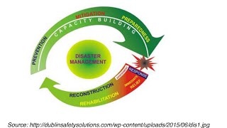
Combining Approaches for Risk Mapping
Chapter 5 of 5
🔒 Unlock Audio Chapter
Sign up and enroll to access the full audio experience
Chapter Content
The use of digital tools to combine social and scientific approaches for a comprehensive flood risk map.
Detailed Explanation
Here, we learn about how different mapping approaches—both social and scientific—were combined using digital tools. This integrated approach aims to create a comprehensive flood risk map that encompasses various aspects of vulnerability. It illustrates the strengths and weaknesses of both methods, emphasizing the importance of combining qualitative social understanding with quantitative scientific data for effective flood risk management.
Examples & Analogies
Imagine creating a digital recipe that fuses two culinary traditions. By blending flavors and techniques from diverse cuisines, the dish becomes richer and more enjoyable, much like how combining different mapping techniques creates a more effective flood risk assessment.
Key Concepts
-
Critical Infrastructure: Essential services like hospitals and police stations that are vital for community functioning.
-
Social Vulnerability: The risk of communities being disproportionately affected by flooding based on social factors.
-
Physical Vulnerability: How well structures can withstand flooding, categorized into different damage levels.
-
Economic Vulnerability: The effect of flooding on businesses, resulting in revenue losses and economic strain.
-
Cultural Vulnerability: The importance of preserving heritage sites that define a community's historical and cultural identity.
Examples & Applications
A hospital in a flood-prone area faces high risk due to its critical role in emergency services.
Businesses along the river front often close during floods, showcasing economic vulnerability.
Cultural heritage sites like monuments are at risk during flooding, highlighting the need for preservation efforts.
Memory Aids
Interactive tools to help you remember key concepts
Rhymes
If floods are to come, get your home and run, / Remember your heritage, it’s not just for fun!
Stories
In a village rich with history, floods threatened the ancestral home. The villagers banded together, categorized their risks, and saved their heritage with a shared strategy.
Memory Tools
Use 'PECS' to remember the categories: P for Physical, E for Economic, C for Cultural, S for Social vulnerabilities.
Acronyms
Remember 'HERC' for Heritage, Economic, Resilience, and Community, highlighting these essential aspects to consider in flood vulnerability.
Flash Cards
Glossary
- Critical Infrastructure
Essential services such as hospitals and police stations that are vital for the functioning of a community.
- Social Vulnerability
The susceptibility of a community to harm due to flood risks, influenced by factors such as location and socioeconomic status.
- Physical Vulnerability
The degree of damage that structures face during flooding, classified as high, medium, or low.
- Economic Vulnerability
The impact on the economy and businesses due to flooding, including operational shutdowns and financial losses.
- Cultural Vulnerability
The risk of loss or damage to cultural heritage sites and properties, which hold historical significance.
- Flood Risk Maps
Tools that display the likelihood and potential impact of flooding in various areas.
Reference links
Supplementary resources to enhance your learning experience.