
Characteristics of Precipitation in India
Enroll to start learning
You’ve not yet enrolled in this course. Please enroll for free to listen to audio lessons, classroom podcasts and take practice test.
Interactive Audio Lesson
Listen to a student-teacher conversation explaining the topic in a relatable way.
Types of Precipitation
🔒 Unlock Audio Lesson
Sign up and enroll to listen to this audio lesson

Today we will discuss the types of precipitation found in India. Can anyone name a type of precipitation?

I think there is rain and snow.
Absolutely! In India, we mainly focus on cyclonic, convective, and orographic precipitation. Let’s start with cyclonic precipitation. It mostly occurs along our coastal regions, especially during the pre-monsoon and post-monsoon seasons. Can anyone tell me what causes this type of precipitation?

Is it related to cyclones and depressions?
Exactly! Cyclones from the Bay of Bengal and Arabian Sea can lead to intense rainfall. This can cause flash floods, particularly in eastern and southern India. Now, what's convective precipitation?

Doesn’t that happen when the land heats up in the summer?
Correct! Convective precipitation results from vertical air currents due to intense land heating, resulting in short but heavy rainfall. Lastly, can anyone describe orographic precipitation?

That’s when moist air is forced up by mountains, right?
Exactly right! The Western Ghats and Himalayas receive a lot of rainfall this way. Great job, everyone! Remember, types of precipitation can significantly affect our water resources and landscape.
Spatial and Temporal Distribution
🔒 Unlock Audio Lesson
Sign up and enroll to listen to this audio lesson

Now, let’s move on to the distribution of precipitation. Why do you think the rainfall patterns in India are so uneven?
Different places have different climates and terrain?
Exactly! For example, in western Rajasthan, we see less than 100 mm of rain annually, while in Cherrapunji, it can exceed 11,000 mm! This variation can be linked to geographical features. Can anyone tell me about the seasonal aspects of this distribution?
Most of the rain comes during the monsoon?
That's right! About 75-90% of annual rainfall occurs during the Southwest Monsoon. This fully impacts crop patterns and water availability. Excellent insights, team!
Monsoon Systems
🔒 Unlock Audio Lesson
Sign up and enroll to listen to this audio lesson
Let’s delve into the monsoon systems and their influence. Who can explain what the Southwest Monsoon is?
It brings rain to Kerala first in June, right?
Yes! This monsoon is vital for our agriculture. The differential heating between land and ocean causes it. What about the Northeast Monsoon?
That one happens from October to December and affects places like Tamil Nadu?
Correct! It brings moisture from the Bay of Bengal. Lastly, have any of you heard about Western Disturbances?
Are they related to winter rains in the north?
Right again! They bring rainfall and sometimes snowfall to the Himalayas. Remember, these are crucial for our winter water needs too!
Introduction & Overview
Read summaries of the section's main ideas at different levels of detail.
Quick Overview
Standard
Precipitation in India varies significantly due to its geographical and climatic diversity. This section discusses types of precipitation including cyclonic, convective, and orographic, as well as their spatial and temporal distributions, influencing factors like monsoons, and the implications in hydrology and engineering.
Detailed
Characteristics of Precipitation in India
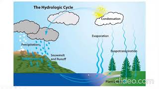
Precipitation is a key component of the hydrological cycle, crucial for managing water resources in India. The vast geographical spread of India leads to varied precipitation characteristics, including different types (cyclonic, convective, and orographic), highly uneven spatial distribution, and specific temporal patterns linked to monsoon systems. The Southwest and Northeast Monsoons are significant contributors, with most rainfall occurring from June to September. Precipitation intensity, duration, and frequency are also examined, contributing to the understanding of rainfall variability that impacts agricultural productivity and infrastructure planning. Understanding these characteristics is essential for enhancing flood management, optimizing reservoir designs, and advancing irrigation and watershed management practices.
Youtube Videos


Audio Book
Dive deep into the subject with an immersive audiobook experience.
Introduction to Precipitation
Chapter 1 of 8
🔒 Unlock Audio Chapter
Sign up and enroll to access the full audio experience
Chapter Content
Precipitation is the primary input in the hydrological cycle and plays a central role in determining the availability of surface and groundwater resources. In India, due to its vast geographical spread and diverse climatic conditions, precipitation exhibits a wider range of characteristics. Understanding these variations is crucial for planning and managing water resources, designing hydraulic structures, and predicting floods and droughts.
Detailed Explanation
Precipitation, which includes all forms of moisture that fall from clouds, such as rain, snow, sleet, and hail, is essential for replenishing both surface and groundwater sources. In India, the nature of precipitation varies significantly across different regions due to varying climates and geography. This understanding is vital because it influences how we manage water resources, prepare for extreme weather events like floods and droughts, and design buildings and infrastructures like dams and drainage systems to handle varying water levels.
Examples & Analogies
Think of precipitation like the water your garden needs to thrive. Just as different plants require specific amounts of sunlight and water, different regions in India have unique precipitation requirements that must be understood for effective water management. For instance, a desert region needs efficient irrigation strategies, while a lush area could cope with more rainfall without causing issues.
Types of Precipitation in India
Chapter 2 of 8
🔒 Unlock Audio Chapter
Sign up and enroll to access the full audio experience
Chapter Content
Precipitation occurs in several forms, and each has distinct hydrological implications. In the Indian context, the following types are prominent:
5.1.1 Cyclonic Precipitation
- Common along coastal areas during the pre-monsoon and post-monsoon seasons.
- Associated with low-pressure systems (depressions, cyclones) originating over the Bay of Bengal and Arabian Sea.
- Often causes intense rainfall over short durations, leading to flash floods in eastern and southern India.
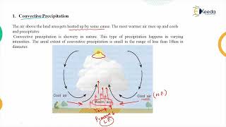
5.1.2 Convective Precipitation
- Occurs due to intense heating of land surfaces, resulting in vertical air currents.
- Predominant in the interior parts of the country during summer.
- Rainfall is of short duration but high intensity.
5.1.3 Orographic Precipitation
- Occurs when moist air masses are forced to rise over mountain ranges.
- The Western Ghats and the Himalayan foothills receive heavy orographic rainfall.
- Windward side receives maximum rainfall; leeward side remains relatively dry (rain shadow region).
Detailed Explanation
In India, precipitation can be categorized into three major types:
1. Cyclonic Precipitation: This type occurs mainly along coastal regions when low-pressure weather systems develop over oceans, especially during the monsoon months, leading to heavy rains that can cause flash floods.
2. Convective Precipitation: This is generated from intense heat that causes rapid uplift of air, resulting in isolated thunderstorms, especially in interior regions during summer.
3. Orographic Precipitation: This occurs when moist air is forced up by mountains, leading to heavy rainfall on one side of the hill (windward) while creating dry conditions on the other side (leeward), which is known as the rain shadow effect.
Examples & Analogies
Imagine standing in front of a mountain during a rainy season. The side facing the sea gets drenched with rain, while the other side is sunny and dry. This illustrates orographic precipitation. Similarly, think about a hot summer day when you feel a sudden downpour; that’s likely heavy convective precipitation caused by rising warm air.
Distribution of Precipitation
Chapter 3 of 8
🔒 Unlock Audio Chapter
Sign up and enroll to access the full audio experience
Chapter Content
5.2 Distribution of Precipitation in India
5.2.1 Spatial Distribution
- Highly Uneven: Annual rainfall varies from less than 100 mm in western Rajasthan to over 11,000 mm in Cherrapunji, Meghalaya.
- Major Rainfall Zones:
– High Rainfall Areas: Northeastern states, Western Ghats, and parts of West Bengal.
– Low Rainfall Areas: Rajasthan, parts of Gujarat, Leh-Ladakh.
5.2.2 Temporal Distribution
- Seasonal Concentration: About 75–90% of annual rainfall occurs during the Southwest Monsoon (June–September).
- Remaining Rainfall: During winter (Northeast Monsoon) and pre-monsoon thunderstorms.
Detailed Explanation
The distribution of precipitation across India is characterized by two dimensions: spatial and temporal.
1. Spatial Distribution: Rainfall varies significantly across different regions; for instance, some areas like Cherrapunji receive over 11,000 mm of rain annually, while western Rajasthan sees less than 100 mm. This highlights the extreme disparities in moisture availability. Major zones of rainfall include regions with heavy rainfall like the Northeastern states and the Western Ghats, contrasting sharply with dry areas like Rajasthan.
2. Temporal Distribution: Precipitation is not only uneven spatially but also temporally concentrated. Most of the annual rainfall (75-90%) occurs during the Southwest Monsoon, which spans from June to September, leaving the remaining months to account for lesser rainfall events during other seasons.
Examples & Analogies
Consider a sponge in a shower. Some sponges are drenching wet (like Cherrapunji), while others barely get touched by the water (like western Rajasthan). This represents how different regions perceive rainfall. In terms of timing, think of a busy restaurant where most customers arrive during dinner rush hours—the same concept applies to how rain falls heavily during specific seasons in India.
Monsoon Systems
Chapter 4 of 8
🔒 Unlock Audio Chapter
Sign up and enroll to access the full audio experience
Chapter Content
5.3 Monsoon Systems and Their Influence
5.3.1 Southwest Monsoon
- Primary source of rainfall.
- Caused by differential heating between land and ocean.
- Winds blow from the Indian Ocean toward the subcontinent, bringing moisture-laden air.
- Hits Kerala coast by early June and advances northward.
5.3.2 Northeast Monsoon
- Occurs during October to December.
- Affects Tamil Nadu, Andhra Pradesh, and parts of Karnataka.
- Winds blow from the northeast, picking moisture from the Bay of Bengal.
5.3.3 Western Disturbances
- Affect north and northwest India during winter months.
- Bring snowfall in the Himalayas and moderate rainfall in Punjab, Haryana, and western Uttar Pradesh.
Detailed Explanation
India's rainfall heavily relies on distinct monsoon systems:
1. Southwest Monsoon: This is the most critical monsoon, occurring from June to September, driven by temperature differences between land and sea that create moisture-laden winds from the Indian Ocean. This system initiates rainfall starting from Kerala and moves northwards across the country, covering vast regions.
2. Northeast Monsoon: Happening from October to December, this system mainly influences southeastern states like Tamil Nadu. It brings precipitation through winds from the northeast that pick up moisture from the Bay of Bengal.
3. Western Disturbances: During the winter months, this system originates from the Mediterranean, bringing occasional rain and snowfall to northern India, including the Himalayas, and moderate rainfall to regions like Punjab and Haryana.
Examples & Analogies
Imagine the Southwest Monsoon as a giant sponge loaded with water that starts pouring over India as the summer heats up. The Northeast Monsoon is like a gentle drizzle that arrives after the rush. Western disturbances act like surprise guests who drop by during winter, bringing unexpected showers and snow. Each type has its own timing and impact, explaining how weather systems shape the lives of people in India.
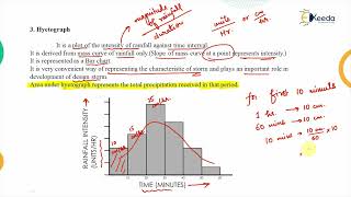
Rainfall Intensity, Duration, and Frequency
Chapter 5 of 8
🔒 Unlock Audio Chapter
Sign up and enroll to access the full audio experience
Chapter Content
5.4 Intensity, Duration, and Frequency of Rainfall
5.4.1 Rainfall Intensity
- Measured in mm/hr.
- High-intensity rainfalls (>50 mm/hr) cause urban flooding and erosion.
- Design of drainage systems and culverts depends on rainfall intensity.
5.4.2 Rainfall Duration
- Duration varies from a few minutes to several hours or days.
- Longer durations with moderate intensities are typical during monsoon depressions.
- Important for estimating runoff volumes and reservoir design.
5.4.3 Rainfall Frequency
- Refers to the probability of occurrence of a particular magnitude of rainfall.
- Essential in hydrological modeling, return period analysis (e.g., 100-year flood).
- Frequency analysis involves Gumbel or Log-Pearson Type III distributions.
Detailed Explanation
Rainfall can be analyzed by three key factors:
1. Rainfall Intensity: This refers to how much rain falls over a specific time period, measured in millimeters per hour (mm/hr). High intensities can lead to severe flooding, especially in urban areas where drainage systems may be overwhelmed.
2. Rainfall Duration: This aspect looks at how long the rain lasts, which can range from brief showers to multi-day downpours. Longer, steady rains are crucial for planning water storage and understanding potential runoff for rivers and dams.
3. Rainfall Frequency: This measures the likelihood of rainfall of a certain intensity occurring within a specific timeframe, helping scientists and engineers design infrastructure that can withstand expected flood risks, such as the 100-year flood event.
Examples & Analogies
Think of rainfall intensity like the speed of water coming from a garden hose. If it’s on full blast, it can quickly flood the garden (high intensity); if it’s just a trickle, it waters the plants slowly and steadily (low intensity). Duration is like timing a traffic light—some stay on for a few minutes, while others last much longer. Frequency is like counting how often it snows in winter—planning for the worst helps prepare for future storms.
Rainfall Variability and Trends
Chapter 6 of 8
🔒 Unlock Audio Chapter
Sign up and enroll to access the full audio experience
Chapter Content
5.5 Rainfall Variability and Trends
5.5.1 Inter-Annual Variability
- India’s rainfall is subject to significant year-to-year variation.
- El Niño and La Niña events greatly influence monsoon behavior.
- Droughts and floods occur cyclically due to such anomalies.
5.5.2 Intra-Seasonal Variability
- Breaks and active spells within the monsoon season.
- Affects crop yield, irrigation planning, and water resource management.
- Breaks are periods of little or no rainfall, particularly in central India.
5.5.3 Long-Term Trends
- Studies indicate no significant increasing or decreasing trend in average annual rainfall over India.
- However, localized changes, urbanization, and deforestation affect regional rainfall patterns.
Detailed Explanation
Rainfall in India shows variability across different timelines:
1. Inter-Annual Variability: Rainfall can fluctuate drastically from year to year due to climatic phenomena like El Niño and La Niña, which influence the strength of the monsoon. These factors lead to cycles of droughts and floods, challenging water management efforts.
2. Intra-Seasonal Variability: Within the monsoon season, periods of heavy rainfall (active spells) can be interrupted by dry spells (breaks), affecting agriculture and water resources significantly, requiring more adaptive management strategies.
3. Long-Term Trends: Research suggests that, broadly, India's average annual rainfall has remained stable over time. However, local factors such as urban development and environmental changes can lead to varying rainfall experiences across different areas.
Examples & Analogies
Imagine trying to predict the weather in a busy city like Mumbai—it can change dramatically from year to year, and even within the same monsoon season. One year might bring ample rain, while another leaves the city dry. Similarly, it's important for farmers to keep an eye on both seasonal patterns and longer-term changes to optimize their crop management and ensure a good yield.
Measurement and Observation of Precipitation
Chapter 7 of 8
🔒 Unlock Audio Chapter
Sign up and enroll to access the full audio experience
Chapter Content
5.6 Measurement and Observation of Precipitation
5.6.1 Rain Gauge Networks
- Maintained by the Indian Meteorological Department (IMD), CWC, and state agencies.
- Standard rain gauges and recording rain gauges (e.g., tipping bucket, weighing type) used.
5.6.2 Radar and Satellite Observations
- Doppler Weather Radars used for real-time tracking of rainfall.
- INSAT and IRS satellites monitor cloud movement and rainfall estimates.
5.6.3 Data Quality and Challenges
- Inadequate station density in remote regions.
- Data gaps, inconsistency due to manual readings.
- Automation and remote sensing are improving coverage and accuracy.
Detailed Explanation
Accurate measurement of precipitation is vital for understanding water resources:
1. Rain Gauge Networks: Organizations such as the Indian Meteorological Department maintain a network of rain gauges, which can be manual or automated, to collect data on rainfall amounts across various locations.
2. Radar and Satellite Observations: Advanced technology including Doppler radar provides real-time data on rainfall, while satellites like INSAT and IRS observe cloud formations and precipitation over larger areas.
3. Data Quality and Challenges: Despite advancements, there's a challenge in monitoring remote areas due to sparse gauge networks, leading to gaps in data. Ongoing improvements in automation and remote sensing techniques are essential for enhancing measurement accuracy.
Examples & Analogies
Think of rain gauges like measuring cups for cooking—they help ensure we know exactly how much rainfall we receive. Just as a chef relies on accurate measurements to create a recipe, meteorologists depend on precise rainfall data to predict weather and manage water resources effectively.
Implications for Hydrologic Engineering
Chapter 8 of 8
🔒 Unlock Audio Chapter
Sign up and enroll to access the full audio experience
Chapter Content
5.7 Implications of Precipitation Characteristics for Hydrologic Engineering
- Flood Management: Intensity and frequency data help in flood forecasting and designing embankments.
- Reservoir Design: Temporal rainfall patterns crucial for estimating dependable yield.
- Irrigation Planning: Seasonal concentration and breaks affect water availability for agriculture.
- Urban Drainage Systems: High-intensity rainfall requires well-designed stormwater systems.
- Watershed Management: Spatial variation helps in prioritizing regions for soil and water conservation.
Detailed Explanation
The characteristics of precipitation significantly affect various aspects of hydrologic engineering:
1. Flood Management: Understanding the intensity and frequency of rainfall assists engineers inaccurately forecasting flood events, thus designing effective flood management systems, including embankments.
2. Reservoir Design: Recognizing seasonal rainfall patterns is vital to ensure that reservoirs can adequately store and manage water during peak flow periods.
3. Irrigation Planning: Variations in rainfall influence the planning of irrigation systems to ensure crops receive sufficient water.
4. Urban Drainage Systems: High-intensity rainfall necessitates the design of proper drainage infrastructure to prevent city flooding.
5. Watershed Management: By analyzing spatial variations in rainfall, planners can develop strategies for effective land and water conservation efforts across regions.
Examples & Analogies
Imagine a city facing the risk of flooding after a heavy rainstorm. Engineers analyze past rainfall data to ensure drainage systems are capable of handling potential floods, much like how a plumber will size pipes correctly to handle anticipated flows. Effective planning and management based on reliable precipitation data are crucial to avoid damage and maintain water safety.
Key Concepts
-
Cyclonic Precipitation: Rain associated with cyclonic conditions, which can lead to heavy rainfall especially in coastal areas.
-
Convective Precipitation: Resulting from local heating, leading to short duration but high-intensity rain events.
-
Orographic Precipitation: Occurs when geographic features like mountains influence rainfall patterns by forcing air upward.
Examples & Applications
Cherrapunji, Meghalaya receives over 11,000 mm of rain annually due to orographic precipitation.
The interior regions like Rajasthan may receive less than 100 mm of rain, showcasing significant spatial variation.
Memory Aids
Interactive tools to help you remember key concepts
Rhymes
Cyclonic winds flow, heavy rains they sow; Convective heat, short rains they meet; Orographic heights, clouds soar in flights.
Stories
Imagine a coastal town preparing for a cyclone; the heavy rains arrive swiftly, causing floods. Meanwhile, in the hot interior, the land heats up and clouds burst with rain, while the mountains block moisture, leaving a dry valley behind.
Memory Tools
C-O-O: Cyclonic, Orographic, Convective - types of precipitation to remember.
Acronyms
MOIST
Monsoon
Orographic
Intensity
Spatial
Temporal - key characteristics of precipitation.
Flash Cards
Glossary
- Cyclonic Precipitation
Rainfall associated with low-pressure systems such as depressions and cyclones.
- Convective Precipitation
Rainfall caused by the intense heating of the earth's surface, resulting in vertical air currents.
- Orographic Precipitation
Rainfall that occurs when moist air is forced to rise over mountains, leading to heavy rain on the windward side.
- Monsoon
A seasonal prevailing wind that brings heavy rain.
- Rain Shadow Region
An area with significantly less precipitation on the leeward side of a mountain range.
- Intensity of Rainfall
The rate of rainfall measured in millimeters per hour.
- IntraSeasonal Variability
Variations in rainfall patterns within a single monsoon season.
Reference links
Supplementary resources to enhance your learning experience.