
Guidelines and Standards for PMP Estimation
Enroll to start learning
You’ve not yet enrolled in this course. Please enroll for free to listen to audio lessons, classroom podcasts and take practice test.
Interactive Audio Lesson
Listen to a student-teacher conversation explaining the topic in a relatable way.
PMP Guidelines in India
🔒 Unlock Audio Lesson
Sign up and enroll to listen to this audio lesson

Today we are discussing the guidelines for estimating Probable Maximum Precipitation in India. Can anyone tell me why these guidelines are significant?

I think they help in ensuring the safety of hydraulic structures.
Exactly! The Central Water Commission and the India Meteorological Department provide PMP atlases that help assess potential rainfall events. Why do you think it's important to use up-to-date atlases?

Because weather patterns might change and we need the latest data to design structures safely.
Great point! Using the latest data and standards can prevent potential disasters. Let's remember the acronym **CWC-IMD** for Central Water Commission and India Meteorological Department as key contributors in this area.
International Standards for PMP Estimation
🔒 Unlock Audio Lesson
Sign up and enroll to listen to this audio lesson

Moving on to international standards, the World Meteorological Organization publishes guidelines on PMP estimation. Can somebody share why it’s critical to have these international standards?

They ensure consistency across countries in dealing with hydrological safety.
Exactly! And institutions like the United States Bureau of Reclamation provide region-specific criteria. How might this help engineers?

It provides tailored solutions to their specific environmental conditions.
Spot on! Remember the mnemonic **'WMO for World Managing Outcomes'** to help remember the purpose of these international guidelines.
Application of PMP Guidelines in Practice
🔒 Unlock Audio Lesson
Sign up and enroll to listen to this audio lesson
Let’s discuss how these guidelines are applied in practice. Why do you think following these guidelines is beneficial when designing a dam?
Following them helps ensure the dam can withstand maximum rainfall.
Correct! When using PMP estimates, designers can calculate maximum expected flooding scenarios. How do you think this impacts urban planning?
It helps in better flood risk management in urban areas.
Exactly! That's a vital take-home. Always keep in mind the synergy between following guidelines and effective urban planning. Remember, **'Safety First with Standards'**!
Introduction & Overview
Read summaries of the section's main ideas at different levels of detail.
Quick Overview
Standard
The section discusses the structured protocols for PMP estimation provided by institutions like India's Central Water Commission (CWC) and the World Meteorological Organization (WMO). It highlights the significance of adhering to these guidelines in various regions for effective hydrological safety planning.
Detailed
Detailed Summary
This section focuses on the important guidelines and standards for estimating Probable Maximum Precipitation (PMP), which plays a crucial role in hydrological designs and the safety of hydraulic infrastructures. In India, the Central Water Commission (CWC) alongside the India Meteorological Department (IMD) provides dedicated PMP atlases and estimation protocols. These resources are essential for evaluating and managing hydrological safety throughout the nation.
On an international level, the World Meteorological Organization (WMO) publishes comprehensive guidelines regarding PMP estimation, ensuring a standardized approach worldwide. The United States Bureau of Reclamation and the National Weather Service (NWS) provide region-specific PMP values and design criteria, further enhancing the reliability of flood management systems across different geographical areas.
Understanding these guidelines and standards is vital for professionals involved in flood control, dam design, and water management to ensure infrastructure is designed to withstand extreme weather events effectively.
Youtube Videos

![Introduction to Engineering Hydrology and its Applications [Year - 3]](https://img.youtube.com/vi/Sds3dB-hA8E/mqdefault.jpg)


Audio Book
Dive deep into the subject with an immersive audiobook experience.
PMP Estimation in India
Chapter 1 of 2
🔒 Unlock Audio Chapter
Sign up and enroll to access the full audio experience
Chapter Content
- India:
- Central Water Commission (CWC) and India Meteorological Department (IMD) provide PMP atlases and estimation protocols.
Detailed Explanation
In India, the Central Water Commission (CWC) and the India Meteorological Department (IMD) are responsible for providing guidelines on how to estimate Probable Maximum Precipitation (PMP). They create 'PMP atlases' which are comprehensive resources that contain information about PMP estimates across various geographical areas. These atlases serve as critical tools for engineers and planners to ensure that infrastructure can withstand extreme weather events.
Examples & Analogies
Imagine trying to prepare your house for a potential flood due to heavy rains. Just like you would check local flood maps provided by the city to understand your risk and make necessary adjustments (like elevating electrical outlets), engineers use PMP atlases created by CWC and IMD to design dams and other structures that can handle extreme rainfall.
International Guidelines for PMP Estimation
Chapter 2 of 2
🔒 Unlock Audio Chapter
Sign up and enroll to access the full audio experience
Chapter Content
- International:
- World Meteorological Organization (WMO) publishes guidelines on PMP estimation.
- United States Bureau of Reclamation and National Weather Service (NWS) offer region-specific PMP values and design criteria.
Detailed Explanation
On the international stage, the World Meteorological Organization (WMO) provides a framework of guidelines for estimating PMP across different regions of the world. These guidelines are essential because they help ensure consistency and reliability in how PMP is assessed globally. Additionally, organizations like the United States Bureau of Reclamation and the National Weather Service (NWS) provide specific PMP values tailored to regions within the U.S. This geographic specificity helps local engineers design structures that are not only safe but also optimized for the typical weather patterns found in their areas.
Examples & Analogies
Think of it like having different sets of rules for different sports. In basketball, the hoop is at 10 feet, but in volleyball, the net is at a different height. Just like how sports have specific rules based on the environment, the PMP guidelines provided by WMO and other organizations help engineers adopt the right strategies based on the unique weather patterns of their locality.
Key Concepts
-
PMP Guidelines: Important rules established by organizations for estimating precipitation.
-
CWC and IMD: Indian agencies providing vital data on rainfall and PMP.
-
International Standards: WMO's guidelines that unify global approaches to PMP estimation.
Examples & Applications
The CWC's preparation of PMP atlases showcases how historical data and meteorological principles guide the estimation process.
WMO's guidelines help engineers in different regions standardize their PMP calculations, ensuring global safety standards are maintained.
Memory Aids
Interactive tools to help you remember key concepts
Rhymes
PMP might seem hard to see, but it helps keep waters free!
Stories
Imagine engineers working together to ensure safety. They follow guidelines and create dams that can withstand the heaviest rains to protect cities.
Memory Tools
Remember 'CWC' - 'Critical Water Control' to think about the role of Central Water Commission.
Acronyms
WMO
'Weather Matters Organization'
emphasizing their importance in setting global standards.
Flash Cards
Glossary
- PMP
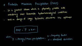
Probable Maximum Precipitation, the greatest depth of precipitation for a specific duration that is physically possible at a given location.
- CWC
Central Water Commission, the agency responsible for water resource development in India.
- IMD
India Meteorological Department, the agency providing weather data and climate research in India.
- WMO
World Meteorological Organization, a specialized agency of the United Nations for meteorology.
- PMP Atlases
Maps provided by CWC and IMD that indicate maximum precipitation estimates for various regions.
Reference links
Supplementary resources to enhance your learning experience.