
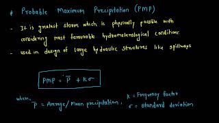
Probable Maximum Precipitation (PMP)
Enroll to start learning
You’ve not yet enrolled in this course. Please enroll for free to listen to audio lessons, classroom podcasts and take practice test.
Interactive Audio Lesson
Listen to a student-teacher conversation explaining the topic in a relatable way.
Understanding PMP
🔒 Unlock Audio Lesson
Sign up and enroll to listen to this audio lesson

Today, we're going to explore the concept of Probable Maximum Precipitation, or PMP. Can anyone tell me what they think PMP stands for?

I think it refers to the maximum amount of rainfall that can be expected in a certain area.
Exactly! PMP is the greatest depth of precipitation that could possibly occur in a given area for a specific duration of time. It's crucial for designing dams and flood protection systems.

Why is it so important for infrastructure safety?
Great question! The failure of structures like dams can lead to catastrophic flooding. Knowing the PMP helps engineers design these structures to withstand extreme weather conditions.

So, PMP helps to prevent disasters?
Absolutely right! In summary, PMP is essential not just for infrastructure safety but also to comply with national and international safety standards.
Factors Influencing PMP
🔒 Unlock Audio Lesson
Sign up and enroll to listen to this audio lesson

Moving on, let's talk about the key factors that influence PMP estimates. Can anyone name one of these factors?

How about atmospheric moisture content?
Correct! The atmosphere's capacity to hold moisture is critical. Other factors include storm efficiency and topography—like mountains and valleys that can enhance precipitation through orographic lifting.
What does storm efficiency mean?
Great question! Storm efficiency refers to how effectively moisture in the atmosphere is turned into precipitation. It's important for understanding how much rainfall can actually occur during a storm.
So, if we have more moisture, we could have heavier rainfall?
Exactly! In summary, understanding these factors is critical in accurately estimating PMP.
Methods of Estimating PMP
🔒 Unlock Audio Lesson
Sign up and enroll to listen to this audio lesson
Let's discuss how we can estimate PMP. One of the primary methods is the Statistical Method. Who can explain how that works?
I think it uses historical rainfall data to find the extremes?
Exactly correct! But this method has limitations, especially in areas with limited data. We also have the Hydrometeorological method, which utilizes actual storm events and then scales up the moisture contents.
How do we apply this data practically?
Good question! These methods help us predict potential floods and guide design for infrastructures like dams and drainage systems.
What about numerical weather modeling? How does that fit in?
Excellent point! Numerical weather modeling uses advanced simulations to predict storm conditions. Understanding the different methods aids engineers in correctly assessing PMP.
Applications of PMP
🔒 Unlock Audio Lesson
Sign up and enroll to listen to this audio lesson
Now, let’s talk about where PMP is used in real-world applications. Can anyone give an example?
I know it’s crucial for designing dams.
Exactly! Dams need to be designed to handle the PMF derived from PMP estimates. What else?
I think it’s also used for flood hazard mapping?
Correct! It helps in assessing flood risks and prepares emergency plans. Furthermore, it's vital for urban drainage systems to manage intense rainfall.
And for nuclear plants, right? They need to be safe from extreme weather?
Absolutely! In summary, PMP applications are critical for ensuring safety across various infrastructures.
Introduction & Overview
Read summaries of the section's main ideas at different levels of detail.
Quick Overview
Standard
PMP is utilized in hydrological design for critical infrastructures to prevent failures during extreme weather events. It incorporates various meteorological and geographic factors to estimate extreme precipitation, aiding in risk assessment and compliance with safety standards.
Detailed
Probable Maximum Precipitation (PMP)
Probable Maximum Precipitation (PMP) is a crucial concept in the field of hydrology and is particularly relevant in the design and safety assessment of critical hydraulic structures like dams and spillways. Defined as the maximum depth of precipitation that is physically possible for a specific area and time, PMP takes into account atmospheric conditions, storm paths, and geographical features. Unlike historical data which only captures past events, PMP incorporates advanced meteorological principles to project extreme storm scenarios which can lead to catastrophic consequences if not adequately designed for.
Key Points:
- Definition: The theoretically maximum precipitation possible for a designated time and location, going beyond historical patterns.
- Significance: Essential for ensuring safe design in critical infrastructures, forms the basis of the Probable Maximum Flood (PMF), aids in risk evaluation, and aligns design with safety standards.
- Factors Influencing PMP: Atmospheric moisture, storm efficiency, topography, storm path, and temperature significantly influence PMP estimates.
- Estimation Methods: Various techniques including Statistical Methods, Hydrometeorological Methods, and Numerical Weather Modeling are employed to estimate PMP.
- Applications: PMP is used in designing dams, assessing flood hazards, planning urban drainage systems, and ensuring safety for nuclear facilities.
- Limitations: Challenges include data availability, reliance on historical data assumptions, potential inaccuracies in storm transposition, and considerations regarding climate change.
- Impact of Climate Change: Changes in climate lead to variations in moisture-holding capacity, necessitating revisions of current PMP estimates.
PMP is critical not only for infrastructure safety but also for proactive measures to address extreme climate impacts.
Youtube Videos


Audio Book
Dive deep into the subject with an immersive audiobook experience.
Definition and Significance of PMP
Chapter 1 of 6
🔒 Unlock Audio Chapter
Sign up and enroll to access the full audio experience
Chapter Content
• Definition: PMP is the theoretically greatest amount of precipitation that is meteorologically possible for a specific location and time.
• Significance:
– Used for hydrological safety design of critical structures (e.g., dams, nuclear plants).
– Basis for determining the Probable Maximum Flood (PMF).
– Helps in evaluating the risk and performance of infrastructure under extreme conditions.
– Ensures compliance with national and international safety standards.
Detailed Explanation
The section begins by defining Probable Maximum Precipitation (PMP) as the maximum amount of rain that could fall in a specific area and time under the most extreme meteorological conditions. This isn't just based on historical rainfall data, but rather represents a theoretical maximum that can occur. Understanding PMP is crucial for engineers and planners, particularly for the design of structures like dams, where a failure could be disastrous. By using PMP values, they can determine a structure's capacity to handle extreme rainfall and thus prevent flooding or structural failure. It also plays a significant role in flood forecasts and risk management by allowing for informed planning that complies with relevant safety regulations.
Examples & Analogies
Think of it like preparing for a big storm. You wouldn't just rely on what storms have happened in the past. Instead, you would consider the worst storm imaginable to ensure your roof can handle it. Similarly, PMP is like the ultimate storm scenario engineers prepare for, ensuring that essential structures can withstand even the most extreme weather conditions.
Factors Influencing PMP
Chapter 2 of 6
🔒 Unlock Audio Chapter
Sign up and enroll to access the full audio experience
Chapter Content
PMP estimation depends on a variety of meteorological and geographic conditions:
- Atmospheric Moisture Content: The capacity of the atmosphere to hold moisture.
- Storm Efficiency: How effectively atmospheric moisture is converted into precipitation.
- Topographic Features: Mountains, valleys, and elevation changes affect orographic lifting.
- Storm Path and Duration: The trajectory and longevity of storm systems.
- Temperature: Impacts both evaporation and the type of precipitation (e.g., snow or rain).
Detailed Explanation
This chunk explores the various factors that influence how PMP is estimated. It includes atmospheric moisture content, which refers to how much moisture the air can hold, impacting potential rainfall. Storm efficiency indicates how effectively this available moisture is transformed into precipitation. Geographic features also play a key role; for example, mountains can force air upwards (orographic lifting), leading to rainfall. Additionally, the path a storm takes and how long it lasts can change how much rain falls in an area, as can temperature, which affects evaporation and precipitation types. All these factors together inform the calculation of PMP, making it a complex but essential process.
Examples & Analogies
Imagine you're baking a cake. The amount of flour (atmospheric moisture), how well you mix it (storm efficiency), the shape of your baking pan (topographic features), how long you bake it (storm duration), and your oven temperature (temperature) all affect the final result. Similarly, each of these factors contributes to determining the maximum possible rainfall in a given situation.
Estimation Methods of PMP
Chapter 3 of 6
🔒 Unlock Audio Chapter
Sign up and enroll to access the full audio experience
Chapter Content
There are primarily three methods used to estimate PMP:
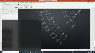
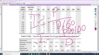
14.3.1 Statistical Method (Empirical Method)
• Based on historical rainfall records and extreme value analysis.
• Limited to regions with long and reliable rainfall data.
• Uses frequency analysis to extrapolate extreme precipitation values.
• Limitations: Assumes past maximum events can predict future extremes, which may not be sufficient for PMP estimation.
14.3.2 Hydrometeorological Method
• Moisture Maximization Approach:
– Based on actual storm events but scaled up using higher moisture content.
– Uses the formula:
\[ PMP = P \times \frac{PW_{max}}{PW_{storm}} \]
• Where:
– P = observed precipitation
– PW_{max} = maximum precipitable water at location
– PW_{storm} = precipitable water during the storm event.
• Transposition Technique:
– Involves applying the characteristics of extreme storms from one region to another.
– Storm data from areas with more extreme weather is 'transposed' geographically.
• Envelopment Curve Method:
– Uses upper limits of rainfall from multiple storms across regions.
– Draws envelope curves representing maximum limits for different durations and areas.
14.3.3 Numerical Weather Modelling
• Advanced method using mesoscale meteorological models.
• Simulates extreme storm events by inputting boundary conditions with maximum moisture.
• Requires supercomputing and expert input.
• Still under research and development in many countries.
Detailed Explanation
This chunk discusses three main methods to estimate PMP, starting with the Statistical Method, which relies on analyzing historical rainfall data. However, this method has limitations, such as the danger of assuming past patterns will continue, potentially underestimating future extremes. The Hydrometeorological Method is explained in several sub-methods, such as the Moisture Maximization Approach, which uses actual rainfall data but scales it up for maximum moisture. The Transposition Technique and the Envelopment Curve Method involve adapting data from known extreme weather events to different regions. Lastly, Numerical Weather Modelling represents the most advanced approach involving complex simulations to forecast extreme weather impacts; however, it demands significant computing resources and expertise.
Examples & Analogies
Imagine you’re trying to estimate how much gas (precipitation) you can get in your tank (area) when driving through a storm. The Statistical Method would be like looking at past gas prices to guess how much you’ll need based on previous trips—useful but might not reflect future trends. The Hydrometeorological Method would be more like testing how much gas you get with various driving patterns in different weather—letting you adapt your estimates based on real-time conditions. Numerical Weather Modelling would resemble using advanced technology to predict how much gas you’ll need based on a detailed analysis of traffic, routes, and weather changes ahead.
Applications of PMP
Chapter 4 of 6
🔒 Unlock Audio Chapter
Sign up and enroll to access the full audio experience
Chapter Content
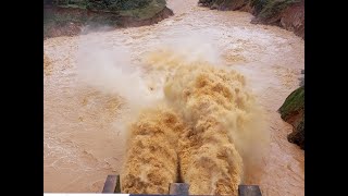
• Design of Dams and Spillways:
– Critical for setting spillway capacity to prevent overtopping.
• Flood Hazard Mapping and Risk Assessment:
– Establishes PMF for emergency preparedness.
• Urban Drainage Systems:
– Helps in designing for rare, high-intensity events.
• Nuclear Facility Safety Design:
– Ensures cooling and containment systems are protected under extreme rainfall.
Detailed Explanation
This section highlights the applications of PMP in various fields. Firstly, PMP is essential in designing dams and spillways; it determines how much water a spillway should handle to prevent overflow and possible failure. In flood hazard mapping, knowing the PMP helps in preparing for emergencies by defining the Probable Maximum Flood (PMF) potential. Urban drainage systems rely on PMP to ensure they can handle rare but intense storms, protecting city infrastructure from runoff. Furthermore, in the design of nuclear facilities, PMP is crucial in ensuring that systems designed to cool and contain are resilient against extreme weather conditions to avoid catastrophic consequences.
Examples & Analogies
Think of PMP in applications like a safety net. When designing a trampoline park, you'd want to know how much weight it can handle jumping at once (analogous to rainfall). Similarly, in dam construction, understanding PMP helps engineers ensure that the dam can handle the worst-case scenario without breaking, much like ensuring that the trampoline doesn't collapse if many kids jump at once.
Limitations and Challenges in PMP Estimation
Chapter 5 of 6
🔒 Unlock Audio Chapter
Sign up and enroll to access the full audio experience
Chapter Content
• Data Availability: Lack of high-quality rainfall and moisture data, especially in remote regions.
• Assumptions in Maximization: Meteorological assumptions may not hold under future climate conditions.
• Transposition Errors: Applying storms from one region to another may lead to inaccuracies.
• Climate Change Uncertainty: Future PMP may be different due to changing atmospheric moisture capacity.
Detailed Explanation
This chunk addresses the challenges in estimating PMP. One major issue is data availability; many remote or underserved regions lack reliable historical rainfall and moisture information, making predictions difficult. Also, the assumptions made about meteorological conditions might not be applicable in the future, particularly as climate change alters weather patterns. Transposing storm characteristics from one location to another can also introduce errors, as storms are heavily influenced by local conditions. Finally, uncertainty regarding climate change means that future calculations of PMP need to be continually revised to ensure they reflect the new atmospheric conditions.
Examples & Analogies
Consider trying to bake a cake recipe that requires specific measurements from different parts of the world—if some ingredients aren't available to you at home, you might get inaccurate results. Similarly, insufficient rainfall data can lead to unclear estimates of the maximum possible precipitation, and future climate change is like unpredictable new recipes that could drastically change the cake's outcome—engineers must adapt their predictions constantly.
PMP and Climate Change
Chapter 6 of 6
🔒 Unlock Audio Chapter
Sign up and enroll to access the full audio experience
Chapter Content
• Warming climate leads to increased moisture-holding capacity in the atmosphere (as per Clausius-Clapeyron relation).
• Potential increase in extreme precipitation events globally.
• Current PMP values may need revision under future climate scenarios.
• Use of Regional Climate Models (RCMs) and Global Climate Models (GCMs) is being explored to project future PMP values.
Detailed Explanation
In this section, the relationship between PMP and climate change is discussed. As the climate warms, the atmosphere can hold more moisture, leading to stronger storms and more intense rainfall events—a concept supported by the Clausius-Clapeyron relation. This means that future PMP estimates may need to be revised upward as climate change progresses. To better understand these likely changes and to estimate future PMP values, scientists are employing regional and global climate models (RCMs and GCMs) to project how rainfall patterns will evolve under changing climate scenarios.
Examples & Analogies
Imagine a sponge: when you warm it up, it'll absorb more water. Similarly, as the planet warms, the atmosphere can ‘hold’ more water, leading to heavier rainfall. This means we have to rethink how much rain to prepare for because storms might become much more severe. Just like updating a recipe as new ingredients become available, scientists are adjusting our understanding of PMP to fit the modern climate reality.
Key Concepts
-
PMP: The maximum depth of precipitation possible in a specific area.
-
Importance of PMP: Critical for infrastructure safety design.
-
Factors Influencing PMP: Includes atmospheric moisture, storm efficiency, and topography.
-
Estimation Methods: Statistical, Hydrometeorological, and Numerical Weather Modeling.
-
Applications of PMP: Used in dam design, flood hazard mapping, and urban infrastructure.
Examples & Applications
In designing a dam, engineers will calculate the PMP to determine the spillway capacity needed to prevent overtopping during rare extreme rainfall events.
Flood hazard mapping relies on PMP estimates to predict areas that may experience flooding during 100-year or 500-year storm events.
Memory Aids
Interactive tools to help you remember key concepts
Rhymes
PMP is key, for flood we see, it helps to keep our structures free.
Stories
Imagine a dam that withstood a wild storm because its engineers prepared for the worst, using PMP to prevent overflowing and keep the community safe.
Memory Tools
PMP - Precipitation Maximum Potential.
Acronyms
P.A.S.T - Precipitation Assessment Using Statistical Trends.
Flash Cards
Glossary
- Probable Maximum Precipitation (PMP)
The theoretically greatest amount of precipitation that can occur at a specific location over a defined duration.
- Hydrometeorological Method
A method of estimating PMP based on maximizing actual storm moisture events.
- Statistical Method
PMP estimation method that analyzes historical precipitation data to project future extremes.
- Moisture Content
The amount of moisture held in the atmosphere which influences precipitation potential.
- Orographic Lifting
The process where air rises over mountains, causing precipitation.
Reference links
Supplementary resources to enhance your learning experience.