
Landforms and Their Formation
Enroll to start learning
You’ve not yet enrolled in this course. Please enroll for free to listen to audio lessons, classroom podcasts and take practice test.
Interactive Audio Lesson
Listen to a student-teacher conversation explaining the topic in a relatable way.
Mountains and Their Formation
🔒 Unlock Audio Lesson
Sign up and enroll to listen to this audio lesson

Today, let's explore mountains. Mountains are formed primarily by tectonic forces, which can include processes such as folding and faulting. Can anyone give me an example of where we might find a significant mountain range?

The Himalayas!
Exactly! The Himalayas were formed by the collision of the Indian and Eurasian plates. Now, how do you think living near mountains might affect people's daily lives?

It might be colder, right?
Correct! Higher altitudes typically mean cooler temperatures. Mountains also affect transportation routes. For instance, crossing a mountain range can be quite challenging.

So, they limit where people can easily travel?
Yes, that's a key point. To remember this connection, you can use the acronym MOUNTAIN—Mountains' Origins Uniquely Affect Nearby Transportation and Isolated Natives. Let's move to the next landform!
Plateaus and Plains
🔒 Unlock Audio Lesson
Sign up and enroll to listen to this audio lesson

Now let's discuss plateaus. Who can tell me what a plateau is?

It's a flat elevated area!
Exactly! Plateaus can be formed by volcanic activity or through uplift. An example is the Deccan Plateau in India. What do you think makes plateaus significant for human activities?
They could have good soil for farming?
That's spot on! They often have fertile volcanic soils, which can support agriculture. However, steep edges can isolate communities. Now, who can summarize the difference between a plateau and a plain?
Plains are flat but not elevated, like the Great Plains, and are formed from sediment deposits. They're great for farming too!
Well done! Remember, PLAIN for 'Provides Land for Agricultural Income Needs.' Watch out for the next landform!
Valleys and Canyons
🔒 Unlock Audio Lesson
Sign up and enroll to listen to this audio lesson
Let’s dive into valleys and canyons. What process do you think creates these formations?
Rivers cutting through the land?
That's correct! Valleys are often formed by rivers eroding the land over time. Canyons are deeper and steeper than valleys. Can anyone name a famous canyon?
The Grand Canyon!
Absolutely! The Grand Canyon was carved by the Colorado River. Why do you think canyons are important to ecosystems?
They might have unique habitats and help with water flow?
Great point! They support diverse ecosystems. Remember the phrase 'Canyon Conservation Creates Biodiversity.' Let’s finish with a look at coastal landforms.
Coastal Landforms
🔒 Unlock Audio Lesson
Sign up and enroll to listen to this audio lesson
Finally, let’s talk about coastal landforms. What types can you think of?
Beaches and estuaries!
Correct! Coastal landforms are shaped by wave action and wind. Estuaries, for instance, where fresh and saltwater meet, are crucial for biodiversity. Why do you think estuaries are important?
They provide habitats for many different species.
Exactly! They support numerous species and are vital for fishing communities. To remember this, think 'Estuarine Ecosystems Ensure Abundant Resources'—this reflects their ecological importance. Let’s recap what we have learned today about these landforms and their roles.
Introduction & Overview
Read summaries of the section's main ideas at different levels of detail.
Quick Overview
Standard
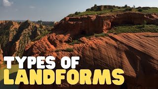
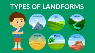
In this section, we discuss Earth’s major landforms, including mountains, plateaus, plains, valleys, and coastal formations, along with the geological processes that create these features. Understanding these landforms is crucial as they influence climate, human settlement, and activities.
Detailed
Overview of Landforms
Earth’s surface is characterized by various landforms shaped by continuous geological processes. These landforms can be categorized based on their formation and features.
Key Landforms and Their Formation
- Mountains: Created by tectonic forces such as folding or faulting. For example, the Himalayas were formed by the collision of the Indian and Eurasian plates. Mountains typically affect the climate of surrounding areas due to their higher altitudes, leading to colder temperatures. Additionally, they can restrict transportation and access to resources.
- Plateaus: Elevated flatlands formed through uplift or volcanic activity. The Deccan Plateau is one such example, known for its fertile volcanic soils. While they can promote agricultural productivity, their steep edges can isolate communities.
- Plains: Flat expanses formed by sediment deposits from rivers or erosion, such as the Great Plains in North America. These regions are often agricultural centers due to their fertile soils, making them crucial for food production.
- Valleys and Canyons: Valleys form between mountains, frequently shaped by river activity, whereas canyons, like the Grand Canyon, represent deeper and steeper sections carved by prolonged river erosion.
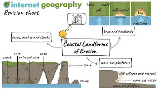
- Coastal Landforms: Includes beaches, cliffs, dunes, and estuaries, shaped predominantly by the interaction of wave action, wind, and sediment transport. Estuaries serve as critical ecosystems where rivers meet oceans, supporting biodiversity and local fishing industries.
Significance of Landforms
Understanding these landforms is vital as they play a crucial role in influencing climate patterns, determining the distribution of human settlements, and impacting economic activities. Knowing where people can settle and how they will utilize resources often depends on the landforms present in a region.
Youtube Videos


Audio Book
Dive deep into the subject with an immersive audiobook experience.
Overview of Earth's Surface Formation
Chapter 1 of 6
🔒 Unlock Audio Chapter
Sign up and enroll to access the full audio experience
Chapter Content
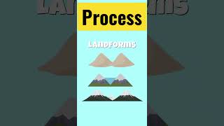
Earth’s surface is shaped by ongoing processes—both constructive (building up) and destructive (breaking down). The major landforms include:
Detailed Explanation
The Earth's surface is constantly changing due to two main types of processes: constructive processes, which build landforms like mountains, and destructive processes, which break down landforms through erosion or weathering. Understanding these processes is essential for grasping how various landforms are created over time.
Examples & Analogies
Think of the Earth like a cake being decorated. When a baker adds layers of cream and fruit, they're building it up (constructive processes), but if they accidentally knock off part of the cake, that's similar to how erosion destroys landforms.
Mountains
Chapter 2 of 6
🔒 Unlock Audio Chapter
Sign up and enroll to access the full audio experience
Chapter Content
● Mountains: Formed primarily by tectonic forces (folding, faulting). For example, the Himalayas arose from the collision of the Indian and Eurasian plates. Mountains affect climate (higher altitudes are colder) and limit ease of transportation.
Detailed Explanation
Mountains are created mainly through the movements of the Earth's tectonic plates. When two plates collide, they can fold and push the ground upwards, forming mountains. An example of this is the Himalayas, which formed when the Indian plate crashed against the Eurasian plate. Additionally, mountains can influence local climates by making higher areas cooler than lower areas, which can affect weather patterns. They can also create challenges for transportation, as the steep terrains make it hard to build roads and railways.
Examples & Analogies
Consider the Himalayas like a very tall stack of pancakes. When you place another pancake on top, it squishes the one below it and forms a taller stack. In this case, the pancakes represent the tectonic plates, and the squash creates mountains.
Plateaus
Chapter 3 of 6
🔒 Unlock Audio Chapter
Sign up and enroll to access the full audio experience
Chapter Content
● Plateaus: Elevated flat areas, often formed by uplift or volcanic activity (e.g., the Deccan Plateau in India). Plateaus can be fertile if volcanic soils are present, but steep edges may isolate communities.
Detailed Explanation
Plateaus are large, flat areas that have been lifted high above the surrounding land, usually due to volcanic activity or the gradual uplift of the Earth's crust. An example is the Deccan Plateau in India. These flat lands can be very fertile if they consist of volcanic soil, which is nutrient-rich. However, the steep edges of plateaus can make it difficult for people to travel in and out, sometimes isolating communities that live in those areas.
Examples & Analogies
Imagine a big pizza that is too thick and high in the middle - that's like a plateau. Even though the top is great for making toppings (fertile soil), it can be tough to reach the middle from the sides (the isolation of communities).
Plains
Chapter 4 of 6
🔒 Unlock Audio Chapter
Sign up and enroll to access the full audio experience
Chapter Content
● Plains: Broad, flat expanses formed by river sediment deposits or erosion (e.g., the Great Plains of North America). Plains are often agricultural heartlands because of rich soils.
Detailed Explanation
Plains are flat, wide areas that are usually formed through the natural processes of sediment deposition from rivers or the gradual erosion of hillsides. A notable example is the Great Plains in North America. These regions often have very fertile soil, making them ideal for agriculture, as they can grow many crops. The combination of flat land and rich soil means that plains can support a large agricultural economy.
Examples & Analogies
You can think of plains like a large, flat table that is perfect for setting up a feast. Just like you would place many different dishes on a flat table to serve food, farmers plant various crops on plains because the land is easy to work with.
Valleys and Canyons
Chapter 5 of 6
🔒 Unlock Audio Chapter
Sign up and enroll to access the full audio experience
Chapter Content
● Valleys and Canyons: Valleys are low areas between mountains, often carved by rivers. Canyons are steep valleys; the Grand Canyon in the United States was carved by the Colorado River over millions of years.
Detailed Explanation
Valleys are typically low areas between mountains and are often shaped by rivers flowing through them. Canyons are a type of valley but are much deeper and steeper. A famous example is the Grand Canyon, which was formed by the Colorado River cutting through rock over millions of years. This carving process illustrates the power of water as a natural force that shapes landscapes.
Examples & Analogies
Think of valleys like a water slide. The slide (river) cuts into the hill (mountain), creating a smooth path down – the valley. The canyon is like a deeper and taller version of that slide, showing how water can dig deep into the land over time.
Coastal Landforms
Chapter 6 of 6
🔒 Unlock Audio Chapter
Sign up and enroll to access the full audio experience
Chapter Content
● Coastal Landforms: Beaches, Cliffs, and Dunes: Shaped by wave action, wind, and sediment movement. Estuaries: Where rivers meet the ocean; these are breeding grounds for many species and often support fishing communities.
Detailed Explanation
Coastal landforms are created through the action of waves, wind, and the movement of sediment. Features like beaches, cliffs, and sand dunes are examples of landforms formed at the interface of land and sea. Estuaries, where freshwater from rivers meets saltwater from the ocean, are rich ecosystems, serving as nursery grounds for fish and supporting local fishing communities.
Examples & Analogies
Imagine the shoreline as a painter's canvas. Waves create textures (beaches and dunes), while wind shapes details (cliffs). Just like a vibrant painting draws attention, estuaries create lush environments where many creatures thrive, just as artists draw inspiration from their surroundings.
Key Concepts
-
Tectonic Activity: The movement of Earth's plates, leading to the creation of mountains.
-
Erosion: The process by which landforms like valleys and canyons are shaped by rivers over time.
-
Sedimentation: The accumulation of sediments, which leads to the formation of plains.
-
Wave Action: The impact of ocean waves on landforms, influencing coastal features.
Examples & Applications
The Himalayas are formed by tectonic collision, influencing climate and transportation.
The Great Plains are extensively used for agriculture due to their fertile soils.
Estuaries provide vital habitats for species and support key fishing industries.
Memory Aids
Interactive tools to help you remember key concepts
Rhymes
Mountains rise high in the sky, plateaus are flat, that's where we sat!
Stories
Once upon a time, there was a great river that shaped a deep canyon. The river whispered to the mountains, and they told tales of their heights, while flat plateaus watched in silence.
Memory Tools
Remember the acronym MAP: Mountains Are Produced by tectonics.
Acronyms
FLOOD for coastal landforms
'Formed by Land and Ocean's Overlapping Dynamics.'
Flash Cards
Glossary
- Landform
A natural feature on the Earth's surface, such as mountains, plateaus, and plains.
- Mountain
A large landform that rises prominently above its surroundings, typically formed by tectonic forces.
- Plateau
An area of elevated flatland, often formed by volcanic activity or uplift.
- Plain
A broad, flat expanse of land formed by the deposition of sediment.
- Valley
A low area of land between hills or mountains, often shaped by river erosion.
- Canyon
A deep and narrow valley with steep sides, often carved by rivers.
- Coastal Landform
Landforms found along coastlines, including beaches, cliffs, and estuaries, shaped by ocean interactions.
Reference links
Supplementary resources to enhance your learning experience.