
Thailand Cave Rescue (2018)
Enroll to start learning
You’ve not yet enrolled in this course. Please enroll for free to listen to audio lessons, classroom podcasts and take practice test.
Interactive Audio Lesson
Listen to a student-teacher conversation explaining the topic in a relatable way.
Introduction to the Thailand Cave Rescue
🔒 Unlock Audio Lesson
Sign up and enroll to listen to this audio lesson

In 2018, a significant rescue operation took place in Thailand when a youth soccer team got trapped in a flooded cave. Can anyone tell me which technologies were crucial in this scenario?

I think they used drones to help find the boys?
Correct! Small, waterproof drones were vital for surveying the cave’s environment. They provided aerial views which helped in strategizing the rescue. What about the underwater parts?

They probably used special underwater robots, right?
Absolutely! Underwater ROVs were essential for navigating the flooded sections. They could explore areas that were too dangerous for humans. How do you think mapping played a role in this rescue?

It helped them plan the rescue routes better!
Exactly! 3D mapping allowed rescuers to pre-plan and visualize their strategies. This case shows the power of robotics in complex rescue operations. Great job everyone!
Key Technologies Used
🔒 Unlock Audio Lesson
Sign up and enroll to listen to this audio lesson

Let’s dive deeper into the technologies used. Why do you think waterproof drones were specifically chosen?

Because they needed to survey the flooded area safely?
Exactly! They allowed the rescue team to gather information without risking human lives. Can anyone explain the importance of the ROVs?
They were able to go underwater to find paths!
That's right! ROVs can navigate complex underwater environments, which human divers found challenging. What about the use of 3D mapping?
It helped in planning the rescue routes and identifying where the boys were!
Fantastic! The combination of these technologies significantly contributed to the success of the operation.
Significance of Robotics in Rescue Operations
🔒 Unlock Audio Lesson
Sign up and enroll to listen to this audio lesson
Reflecting on the operation, why is it essential to have robotics in rescue missions?
Because they can go to places where humans can’t or shouldn’t?
Exactly! Robotics enhances safety and efficiency in rescue operations. In what other scenarios do you think robots can be applied?
Maybe in earthquake rescues or during floods?
Absolutely! Robotics has immense potential across a variety of disaster scenarios. Remember, the integration of technology continues to change how rescues are conducted.
Introduction & Overview
Read summaries of the section's main ideas at different levels of detail.
Quick Overview
Standard
In the 2018 Thailand cave rescue, small, waterproof drones and underwater remotely operated vehicles (ROVs) played a crucial role. They provided essential navigation support in submerged and confined spaces and allowed rescuers to pre-plan routes using 3D mapping technologies, significantly aiding in the successful rescue of the trapped soccer team.
Detailed
Thailand Cave Rescue (2018)
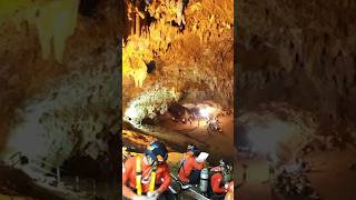
In 2018, a group of twelve boys and their soccer coach became trapped in a flooded cave in Thailand, leading to one of the most complex rescue operations in history. Robotics played a fundamental role in this operation.
Key Technologies Used:
Waterproof Drones:
- Function: Small drones were employed to survey the external cave environment and aid in locating the group, offering aerial perspective and scouting for optimal operation zones.
Underwater ROVs:
- Function: Remotely operated vehicles were utilized for navigation in the flooded parts of the cave system. These ROVs are designed to operate in underwater settings, making them ideal for this scenario.
3D Mapping Technologies:
- Robotics also enabled rescuers to create detailed pre-planning maps of the submerged caverns, allowing lay out of rescue routes and identification of potential hazards. 3D mapping proved invaluable in charting complex underwater passages, significantly contributing to a successful rescue operation.
This case highlights the significance of robotics in challenging rescue operations and emphasizes the need for integration of technology in disaster management strategies.
Youtube Videos


Audio Book
Dive deep into the subject with an immersive audiobook experience.
Deployment of Drones and ROVs
Chapter 1 of 3
🔒 Unlock Audio Chapter
Sign up and enroll to access the full audio experience
Chapter Content
• Use of small, waterproof drones and underwater ROVs
Detailed Explanation
During the Thailand cave rescue in 2018, rescuers utilized small drones that were waterproof. These drones played a crucial role in navigating through the challenging and often submerged environments of the cave system. Additionally, Remote Operated Vehicles (ROVs) designed for underwater use were deployed to enhance the rescue operation.
Examples & Analogies
Think of the waterproof drones as a bird flying in a rainstorm. Just like the bird can maneuver through the harsh weather, the drones were able to fly through the moist and difficult cave conditions. Similarly, the ROVs are like mini submarines, exploring underwater areas where humans could not go.
Navigation Support in Tight Spaces
Chapter 2 of 3
🔒 Unlock Audio Chapter
Sign up and enroll to access the full audio experience
Chapter Content
• Robotics provided navigation support in tight submerged spaces
Detailed Explanation
The use of robotics, particularly through the drones and ROVs, provided essential navigation support in the tight and submerged spaces of the cave. These robots could scout areas that were too dangerous or inaccessible for human rescuers, thus helping in planning the rescue route more effectively and safely.
Examples & Analogies
Imagine trying to find your way through a maze while blindfolded. Now, consider having a friend use a drone to tell you where the walls are and where to turn. The drones acted like those friends—helping the rescuers navigate the complex cave layout.
3D Mapping for Rescue Planning
Chapter 3 of 3
🔒 Unlock Audio Chapter
Sign up and enroll to access the full audio experience
Chapter Content
• Enabled pre-planning of rescue routes with 3D mapping
Detailed Explanation
Robotics technology also facilitated the creation of 3D maps of the cave system. This crucial advance allowed rescuers to visualize the environment in detail before the actual rescue operations began. By pre-planning routes based on these maps, rescuers could strategize their actions to safely and efficiently reach the trapped individuals.
Examples & Analogies
Consider how an architect uses blueprints to design a building. Just like the blueprints offer a detailed view before construction begins, the 3D mapping provided rescuers with a 'blueprint' of the cave, allowing them to plan their actions meticulously.
Key Concepts
-
Use of Technology: The integration of drones and ROVs significantly aided the 2018 Thailand cave rescue operation.
-
Navigation Support: Robotics provided critical support in navigating submerged and rough terrain.
-
Pre-planning with 3D Mapping: The rescue operation utilized 3D mapping to create effective rescue routes.
Examples & Applications
Drones were used to map the cave's layout and identify points of access and danger.
Underwater ROVs performed tasks that were dangerous or impossible for human divers.
Memory Aids
Interactive tools to help you remember key concepts
Rhymes
Drones in the sky, ROVs below, helping to navigate where no human should go!
Stories
Imagine a team lost in a cave under the earth, scared and alone. But above, technology flies through the air and dives underwater, creating maps and light to lead rescuers to a safe path.
Memory Tools
D.R.3 - Drones, ROVs, and 3D mapping were the three keys to the rescue!
Acronyms
Rescue
for Robots
for Efficiency
for Safety
for Coordination
for Unreachable Areas
for Effective Mapping.
Flash Cards
Glossary
- ROV
Remotely Operated Vehicle - a type of underwater robot designed for exploration and inspection in submerged environments.
- 3D Mapping
The process of creating three-dimensional representations of environments to aid in navigation and planning.
- Drones
Unmanned aerial vehicles used for various applications including surveillance and mapping.
- Submerged
Underwater or covered with water.
Reference links
Supplementary resources to enhance your learning experience.