
Modern Field Survey Systems
Enroll to start learning
You’ve not yet enrolled in this course. Please enroll for free to listen to audio lessons, classroom podcasts and take practice test.
Interactive Audio Lesson
Listen to a student-teacher conversation explaining the topic in a relatable way.
Introduction to Electronic Distance Measurement (EDM)
🔒 Unlock Audio Lesson
Sign up and enroll to listen to this audio lesson

Today, we're going to dive into Electronic Distance Measurement (EDM). Let’s start with what it is. EDM is a technology that measures distances using electromagnetic waves. Can anyone tell me how EDM improves the surveying process?

It can measure long distances more accurately compared to traditional methods like tapes.
Exactly! EDM can measure distances up to 100 km with a remarkable accuracy of 1 in 105. This is significantly better than conventional methods. Remember, EDM measures distance by calculating the time it takes for a wave to travel to a reflector and back. Let’s use the acronym LEAD—Light, Electrical waves, Accurate distance—to help remember this!

But how does the EDM know when to stop measuring?
Great question! It uses the phase shift in the wave to determine the exact distance. Now, why do you think accuracy is crucial in surveying?

Because inaccuracies can lead to errors in construction and land boundaries.
Absolutely! Accurate measurements are vital for legal and safety reasons. To summarize, EDM significantly increases efficiency and accuracy in measuring distances in surveying.
Understanding Total Stations
🔒 Unlock Audio Lesson
Sign up and enroll to listen to this audio lesson

Now that we understand EDM, let’s discuss Total Stations. A Total Station integrates the functions of a theodolite and EDM. Can anyone name the key components of a Total Station?

It includes the EDM, an angle-measuring instrument, and a microprocessor.
Correct! The microprocessor is essential as it processes and records the measured data. Can someone brainstorm why a Total Station is advantageous compared to traditional methods?
It saves time and reduces human error.
Exactly! With a Total Station, you can quickly measure distances and angles, which improves overall efficiency in fieldwork. Let’s remember the mnemonic CAPTURE—Compact, Accurate, Processing, Transportable, Usable, Reliable, Efficient—to emphasize these qualities!
Since it can store and process data, does it mean we don't need other equipment?
Good observation! While it helps in reducing equipment load, having additional tools, like prisms, can enhance measurements in certain scenarios. In summary, Total Stations streamline data collection and enhance accuracy.
GPS/GNSS Technology
🔒 Unlock Audio Lesson
Sign up and enroll to listen to this audio lesson
Let’s shift gears and talk about GPS and GNSS systems. Who can tell me what GNSS stands for?
Global Navigation Satellite System!
Correct! GNSS includes various satellite systems, including GPS and others from different countries. How do you think these systems are useful in surveying?
They help determine positions anywhere on Earth, day or night.
Right! They provide 3D coordinates of locations, which simplifies data gathering significantly. Remember the acronym SPACE—Satellites, Precision, Anywhere, Constant, Efficient—to appreciate its functionality!
What about the errors associated with GNSS measurements?
Great question! Errors can arise from atmospheric conditions and obstructions like buildings. Mitigating these errors is essential to ensure reliable data. In summary, GPS/GNSS technology is transformative, making positioning easier and more accurate.
Integrating Surveying Technologies
🔒 Unlock Audio Lesson
Sign up and enroll to listen to this audio lesson
To wrap up, let’s discuss how these technologies work together. How do EDM and Total Stations complement each other in surveying?
Total Stations can use EDM for distance measurement, and together they reduce the time of data collection.
Absolutely! They are complementary in that regard. And what about the relationship between Total Stations and GNSS?
They can be used together to ensure accuracy in challenging environments.
Precisely! Using both can cover limitations such as visibility and line-of-sight issues. Remember the phrase 'Two are better than one' to recall this synergy. Can anyone summarize the significance of these technologies?
They enhance efficiency, accuracy, and ease of use in surveying.
Great summary! The integration of these technologies is essential for modern surveying practices.
Introduction & Overview
Read summaries of the section's main ideas at different levels of detail.
Quick Overview
Standard
In this section, we explore the principles and workings of Electronic Distance Measurement (EDM), categorical differences among Total Stations, and the functionalities of GPS/GNSS systems, emphasizing their impact on field data collection efficiency and accuracy.
Detailed
Modern Field Survey Systems
This unit provides an overview of modern field survey systems, focusing on three main components: Electronic Distance Measurement (EDM), Total Stations, and GPS/GNSS technologies. EDM utilizes electromagnetic waves to achieve precise distance measurement over long ranges. This section explains the principles behind EDM, including its various types and working mechanisms, highlighting its ability to significantly reduce the time and manpower required in traditional surveying methods.
Total Stations represent an integration of EDM and theodolite capabilities, automating both angle and distance measurements. The functioning of Total Stations, including various components and the significance of field measurement processes is elucidated. This tool is not only pivotal in surveying practices but has revolutionized data collection in digital mapping.
Lastly, the section delves into GPS/GNSS technology, explaining its components and modes of operation, and underscoring its role in enhancing accuracy and reliability in locating positions globally. The applications of these tools in various fields emphasize their importance in modern surveying practices, while also discussing common errors encountered and techniques to mitigate them.
Youtube Videos


Audio Book
Dive deep into the subject with an immersive audiobook experience.
Introduction to Modern Surveying
Chapter 1 of 5
🔒 Unlock Audio Chapter
Sign up and enroll to access the full audio experience
Chapter Content
Long distance measurements on the ground by conventional method has always been a problem in surveying. The use of electronics in modern surveying equipment has ease the process. Electronic Distance Measuring (EDM) device can be used for measuring the long distances (slope distances) with higher accuracy, thus saving a lot of time (Garg, 2021). The triangulation and trilateration surveys require accurate measurement of long distances. With the advent of EDMs, it has become easy and fast to measure the long distances.
Detailed Explanation
This chunk discusses the challenges of traditional surveying techniques, particularly in measuring long distances, which can be time-consuming and prone to errors. It introduces Electronic Distance Measuring (EDM) devices, which utilize electronic technology to facilitate accurate distance measurements over long ranges. The EDM significantly simplifies and speeds up the measurement process, making it easier to conduct triangulation and trilateration surveys that require precise distances.
Examples & Analogies
Imagine trying to measure the distance between two points on a large field with a measuring tape. You have to walk back and forth repeatedly, which is not only tiring but can lead to mistakes. Now think of using a laser pointer that gives you an instant distance reading - this is similar to the transition from traditional measuring methods to electronic devices like EDMs.
Total Station Overview
Chapter 2 of 5
🔒 Unlock Audio Chapter
Sign up and enroll to access the full audio experience
Chapter Content
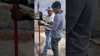
Total Station equipment, which is a combination of digital theodolite, an EDM, and a small processor to process the data, can be used for taking multiple observations in the field, and thus this equipment eliminates the need of taking several surveying equipment in the field, such as theodolite, level, tacheometer, tape, etc. With the advent of Total Station, angular measurements, distance measurement, and height measurements have become quick, easy and accurate (Gopi et.al., 2017).
Detailed Explanation
This chunk explains what a Total Station is, emphasizing that it combines several surveying instruments including a digital theodolite and EDM. This integration allows users to take multiple measurements (angular, distance, and height) without carrying multiple devices. As a result, Total Stations streamline the surveying process, enhancing both speed and accuracy.
Examples & Analogies
Consider a Swiss Army knife, which combines multiple tools into one compact device. Similarly, a Total Station acts as a multi-tool for surveyors, simplifying their work by providing all necessary functions in one instrument.
Global Navigation Satellite System (GNSS)
Chapter 3 of 5
🔒 Unlock Audio Chapter
Sign up and enroll to access the full audio experience
Chapter Content
The Global Positioning System (GPS) traditionally refers to the North American global positioning system, or satellite positioning system. Originally known as Navigation Satellite Timing and Ranging (NAVSTAR), GPS was developed by the US Department of Defense for military use in the 1970s. The Global Navigation Satellite System (GNSS) term refers to the international multi-constellation satellite system, and typically includes GPS, GLONASS, Baidu, Galileo, QZSS, NAVIC, or and any other constellation system.
Detailed Explanation
This section introduces GPS and GNSS. GPS is a specific U.S. system originally designed for military use, while GNSS encompasses all satellite navigation systems globally. GNSS enables users to access multiple satellite signals from various countries, improving the reliability and precision of positioning services.
Examples & Analogies
Think of GNSS as a global team of GPS satellites from different countries working together. Just as a sports team collaborates to win a game, the combined signals from these satellites ensure you get accurate navigation and positioning, no matter where you are on Earth.
Importance of Modern Surveying Technology
Chapter 4 of 5
🔒 Unlock Audio Chapter
Sign up and enroll to access the full audio experience
Chapter Content
The availability of EDM, Total Station and GNSS has eased the data collection and mapping work, and considerable reduced the cost and time to complete the survey work, as compared to conventional surveying equipment (Gopi et. al., 2017).
Detailed Explanation
This chunk highlights the benefits of using EDM, Total Stations, and GNSS in modern surveying. These technologies significantly reduce both the time required for surveys and the associated costs by making data collection more efficient compared to traditional methods.
Examples & Analogies
When you order food online, it often arrives faster than if you called to order and waited. Similarly, modern surveying technologies speed up data collection, making the entire surveying process quicker and more efficient for professionals.
Smart Stations
Chapter 5 of 5
🔒 Unlock Audio Chapter
Sign up and enroll to access the full audio experience
Chapter Content
Looking at the potential use of both (Total Station and GNSS), a combination of both has emerged in the market, called a Smart Station. A Smart Station is an instrument which can be used as a Total Station or as a GNSS or in combination on the same system.
Detailed Explanation
This section introduces the concept of Smart Stations, which combine the functionalities of Total Stations and GNSS into one device. This innovation allows surveyors to efficiently utilize both technologies without needing to alternate between two separate instruments, streamlining fieldwork.
Examples & Analogies
Imagine having a smartphone that seamlessly switches between being a camera and a mini-computer. A Smart Station serves a similar purpose in surveying, easily transforming between functions while saving time and reducing equipment load during projects.
Key Concepts
-
EDM Technology: Measures distances using electromagnetic waves.
-
Total Stations: Combines angle and distance measurement into one instrument, increasing efficiency.
-
GPS/GNSS: Provides global positioning data, essential for accurate surveying.
-
Phase Shift Measurement: Core principle in distance measurement with EDM.
Examples & Applications
An EDM can measure distances of over 100 km with high precision, making it invaluable in vast field surveys.
Total Stations allow surveyors to complete tasks much faster by consolidating multiple measurement instruments into one device.
Memory Aids
Interactive tools to help you remember key concepts
Rhymes
EDM measures the vast expanse, waves in motion make us dance!
Stories
Picture a surveyor on a vast field, using EDM to measure the distance to a hill far away. Each measurement is quick and gathers data effortlessly, making mapping a breeze.
Memory Tools
Remember LEAD for EDM: Light, Electrical waves, Accurate data.
Acronyms
CAPTURE for Total Stations
Compact
Accurate
Processing
Transportable
Usable
Reliable
Efficient.
Flash Cards
Glossary
- Electronic Distance Measurement (EDM)
A device that measures distances using electromagnetic waves for high accuracy.
- Total Station
An integrated surveying instrument that combines a theodolite with an EDM for distance and angle measurement.
- Global Navigation Satellite System (GNSS)
A satellite-based navigation system that provides real-time location and time data globally.
- Signal Phase Shift
The difference in the wave phase between the transmitted and received signal, used to measure distance.
- Prism
A reflecting device used in surveying which reflects the EDM signal back to the instrument.
Reference links
Supplementary resources to enhance your learning experience.