
Plane Tabling
Enroll to start learning
You’ve not yet enrolled in this course. Please enroll for free to listen to audio lessons, classroom podcasts and take practice test.
Interactive Audio Lesson
Listen to a student-teacher conversation explaining the topic in a relatable way.
Introduction to Plane Tabling
🔒 Unlock Audio Lesson
Sign up and enroll to listen to this audio lesson

Today, we’re learning about plane tabling, often referred to as the father of mapping. Does anyone know why it's called that?

I think it's because it's one of the first methods used for creating maps.
Exactly! Plane tabling allowed surveyors to create maps directly in the field, which was revolutionary. This method enables observations, mapping, and contouring to happen simultaneously. Remember, we can use the acronym MAP to help us remember: M for Mapping, A for Accuracy, and P for Placing details.

How accurate is plane tabling compared to other methods?
Great question! While plane tabling is accurate, modern technologies like Total Stations and GPS have enhanced precision, making plane tabling less common today.

So, plane tabling is becoming obsolete?
Correct! Its traditional use is diminishing due to advancements. But understanding its fundamentals is vital for historical context in surveying.
In summary, plane tabling helps surveyors map the terrain accurately and has a significant historical background. Keep MAP in mind as we proceed!
Advantages and Disadvantages of Plane Tabling
🔒 Unlock Audio Lesson
Sign up and enroll to listen to this audio lesson

Now let's talk about the advantages and disadvantages of plane tabling. Would anyone like to start with an advantage?

It allows for map creation right in the field, reducing office work!
Excellent! That's an essential benefit. Since we’re physically there, we can observe the details firsthand, which makes it more reliable. Can anyone identify a disadvantage?
Weather can affect the survey results, right?
Exactly! Weather can be unpredictable and might delay work. Let’s summarize: while field preparation is quick and observations are immediate, we face challenges from environmental factors. Use the acronym PAWS - P for Preparation in field, A for Accurate observations, W for Weather dependency, and S for Surveying details.
What about the heavy equipment?
Good point! The equipment can be cumbersome, making relocations a challenge. So, remembering PAWS can help us keep these pros and cons in mind!
Methods of Plane Tabling
🔒 Unlock Audio Lesson
Sign up and enroll to listen to this audio lesson
Let’s dive into the methods of plane tabling. Who can explain the three main steps involved?
I think they are leveling, centering, and orienting the plane table.
That's correct! Let's remember that with the mnemonic LCO - L for Leveling, C for Centering, and O for Orienting. Why do you think these steps are crucial?
Sounds like they ensure accuracy in our measurements.
Exactly! Accurate leveling ensures the table is horizontal, centering precisely positions it over the survey point, and orienting aligns it with known points. Each step is critical for accurate mapping. Let's wrap up by stating that these methods ensure the effectiveness of the plane tabling technique through LCO.
Surveying Methods in Plane Tabling
🔒 Unlock Audio Lesson
Sign up and enroll to listen to this audio lesson
Next, we talk about the different surveying methods used in plane tabling. Can anyone name a method?
Radiation!
Yes! Radiation is used to locate objects based on distance and direction. Remember RAD for Radiation, A for Accurate, and D for Distance. What’re other methods?
Intersection and traversing?
That's right! Intersection helps in identifying an object using two different directions, while traversing is for mapping around obstructed areas. So we can use RAIN to remember the methods: R for Radiation, A for Area (traversing), and I for Intersection.
Is resection included too?
Correct! Resection helps accurately plot unknown ground stations. So, RAIN should help you remember all methods. Well done!
Introduction & Overview
Read summaries of the section's main ideas at different levels of detail.
Quick Overview
Standard
The section discusses plane tabling as a key method in field surveying for creating maps, detailing its advantages and disadvantages alongside the various methods employed within the technique. Despite its historical significance, modern technology has largely replaced these practices.
Detailed
Plane Tabling
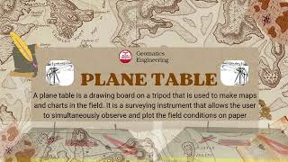
Plane tabling is renowned as the foundational technique for mapping, primarily utilized for creating various maps directly in the field. This graphical methodology enables simultaneous observations, mapping, and contouring, thus enhancing accuracy despite its time-consuming and labor-intensive nature. The fundamental equipment used is a wooden drawing board mounted on a tripod, facilitating accurate plots influenced by the surveyor's direct interactions with the landscape.
However, with advancements in surveying technologies such as Total Stations, GPS, and remote sensing techniques, plane tabling has seen a decline in use. The section further delves into the advantages and disadvantages of this approach:
Advantages:
- Field preparation of maps reduces office workload.
- Real-time observations minimize loss of detail.
- Error-checking mechanisms enhance accuracy.
- Graphical measurements eliminate the need for constant fieldwork.
- Facilitates the rapid plotting of distant objects.
- Overcomes the challenges of magnetic interference in surveys.
Disadvantages:
- Weather dependency can hinder work efficacy.
- Difficulties in dense urban or forested areas.
- Reworking at different scales demands complete re-execution.
- Equipment heaviness complicates transport.
- Paper-based maps can be affected by environmental factors.
- Increased labor and time are required for expansive surveys.
The section outlines the operational methods of plane tabling involving levelling, centering, and orientation practices, alongside primary surveying methods: Radiation, Intersection, Traversing, and Resection. These methods assist surveyors in plotting details efficiently while capturing significant aspects of the territory. Despite its original utility, the obsolescence of plane tabling reflects the rapid technological evolution in civil engineering mapping procedures.
Youtube Videos


Audio Book
Dive deep into the subject with an immersive audiobook experience.
Introduction to Plane Tabling
Chapter 1 of 6
🔒 Unlock Audio Chapter
Sign up and enroll to access the full audio experience
Chapter Content
Plane Table is called the father of 'Mapping'. It is used to prepare various maps in the field. It is a graphical method, where observations, mapping and contouring, proceed simultaneously. It is a time-consuming and laborious process to create a map, but is a more accurate approach. The plane table consists of a wooden drawing board with arrangement of fixing it on a tripod. With the availability of Total Station, GPS, satellite images and LiDAR data, Plane tabling methods of surveying are almost obsolete now-a-days.
Detailed Explanation
Plane tabling is a method used for mapping where the map is created in the field instead of in an office setting. It is termed the 'father of mapping' due to its foundational role in the practice of surveying and cartography. This technique involves using a plane table, which is a simple wooden drawing board that can be set up on a tripod. The advantage of this method is that observations, mapping, and contouring happen simultaneously. However, it can be quite labor-intensive, taking a lot of time to create maps accurately. Despite its accuracy, modern technologies like Total Stations and GPS have made plane tabling less common today.
Examples & Analogies
Imagine trying to create a detailed scrapbook while documenting a family vacation in real-time. You would take photos, write notes, and sketch memories as you experience them. Similar to this, plane tabling allows surveyors to capture precise landscape details as they survey, helping create a more accurate and up-to-date ‘map’ of the area.
Advantages of Plane Table Surveying
Chapter 2 of 6
🔒 Unlock Audio Chapter
Sign up and enroll to access the full audio experience
Chapter Content
Advantages: (a) The map is prepared in the field; therefore, the office work is minimal. (b) The observations and plotting are done simultaneously, and the surveyor can see the terrain before him/her, so chances of losing the details are rare. (c) Errors in plotting the details on plane table can be checked by drawing the check lines using several methods. (d) The angles and distance measurements can be obtained graphically, and hence there is no need to carry out measurements in the field. (e) Many far-off objects/details can be plotted accurately using intersection method to prepare the map in shortest time. (f) It is advantageous in magnetic areas where compass survey is not reliable.
Detailed Explanation
The advantages of plane table surveying include a reduction in office work since maps are made directly in the field. The simultaneous observation and plotting allow surveyors to accurately capture the landscape without the risk of missing important details. Additionally, any plotting errors can be checked using check lines drawn from different locations. The graphical measurement of angles and distances means that actual measurements may not need to be taken in the field. The intersection method enables precise plotting of distant objects quickly, and this technique is also beneficial in locations where magnetic compasses do not function well.
Examples & Analogies
Think of a chef preparing a meal in a busy kitchen while also plating the dishes simultaneously. This allows the chef to see how the ingredients interact and adjust flavors on the spot without needing to remember everything for later, which parallels how surveyors can make immediate adjustments and observations while mapping.
Disadvantages of Plane Table Surveying
Chapter 3 of 6
🔒 Unlock Audio Chapter
Sign up and enroll to access the full audio experience
Chapter Content
Disadvantages: (a) Plane tabling work is dependent on weather conditions (e.g., rains, high winds). (b) The plane table is not very much suitable in a dense forest area or urban area. (c) If survey map is to be replotted at some different scale, entire work has to be re-done. (d) Its accessories are heavy to carry in the field from one location to another. (e) The paper maps are subject to shrinkage or expansion while working in the field for long time. (f) It is laborious and time-consuming to prepare map of a large area. (g) It requires large manpower for doing various activities from observations to plotting.
Detailed Explanation
While plane table surveying has its advantages, it also has several disadvantages. Weather conditions greatly affect the feasibility of surveying; for example, strong winds or rain can hinder operations. This method is less practical in areas with dense vegetation or urban settings where visibility is limited. Additionally, if a map needs to be altered in scale, the entire mapping process must be repeated. The equipment can be cumbersome to carry, and paper maps can change size with temperature or humidity, leading to inaccuracies. Furthermore, creating maps over large areas requires considerable time and manpower.
Examples & Analogies
Imagine trying to set up a picnic but it starts to rain heavily. You have to pack everything up and wait for the weather to clear before you can enjoy your day. Similarly, surveyors may have to halt their work due to unfavorable weather conditions, which can delay their mapping project.
Methods of Plane Tabling
Chapter 4 of 6
🔒 Unlock Audio Chapter
Sign up and enroll to access the full audio experience
Chapter Content
There are three steps to work with plane table: (i) Levelling the plane table, (ii) Centering the plane table, and (iii) Orienting the plane table. Levelling is done using the sprit bubble tube. Centering is done with the help of a plumb bob. Orientation is done either with a magnetic compass or with a back ray method.
Detailed Explanation
To effectively use a plane table, surveyors must follow three key steps: levelling, centering, and orienting. Levelling involves ensuring the plane table is perfectly flat, which can be checked using a spirit level. Centering ensures that the table is positioned directly over a specific point of interest, typically using a plumb bob. Orientation sets the table to face a known direction, which can be accomplished with a magnetic compass or a back ray method to align with reference points on a map.
Examples & Analogies
Think of setting up a camera for a group photo. First, you need to ensure it's level so everyone looks good. Then, you center it on the group, and finally, you aim it in the right direction to capture everyone's smiles. Surveyors do similar things with their plane tables to ensure accurate maps.
Methods of Plane Table Surveying
Chapter 5 of 6
🔒 Unlock Audio Chapter
Sign up and enroll to access the full audio experience
Chapter Content
There are four methods of plane table surveying: (i) Radiation, (ii) Intersection, (iii) Traversing, and (iv) Resection. The radiation method uses of a distance and a direction to locate the object on the map. The plane table is set up at a station and various points in the vicinity are located on the map by measuring the distances to the different stations using a tape (or tacheometry), and subsequently radiating (drawing) the rays from the instrument station to those points which are to be located on the map. The intersection method is used extensively to locate an object by two directions from two stations at the end of a base line of known length. The method is widely used for plotting the far-off details on the maps. The traversing method is used in areas where visibility is obstructed by high-rise building/forest or topography. The resection method is used to accurately locate the position of ground station (unknown point) on the map, occupied by plane table. It is done by drawing the rays from two or three already known and plotted point on the map. Once the position of ground station is plotted on the plane table, any of the method for plotting the details could be used.
Detailed Explanation
There are four primary methods of plane table surveying each suited for different scenarios. The Radiation method involves measuring distances from a central point to various locations, then drawing rays from this point on the map to accurately depict the terrain. The Intersection method helps locate an object by surveying it from two different stations along a known baseline, effectively providing a precise spot based on where the two observation lines cross. The Traversing method is useful when visibility is obstructed, allowing surveyors to plot known points and work from there. Finally, the Resection method allows surveyors to pinpoint an unknown location by referencing known points already mapped. This versatility is what has historically made plane tabling a valuable surveying tool.
Examples & Analogies
Consider a treasure hunt where you have a map with various land markers. Radiation would be like moving straight towards a marker from your treasure map, while the Intersection method would resemble triangulating the treasure's location with clues from two different landmarks on the map. Traversing is like going through a dense forest, plotting signs as you navigate your way through, and Resection could be viewed as using landmarks you pass to verify that you're still headed in the right direction.
Obsolescence of Plane Tabling
Chapter 6 of 6
🔒 Unlock Audio Chapter
Sign up and enroll to access the full audio experience
Chapter Content
Now-a-days, plane tabling is considered as obsolete, and therefore is not carried out in the field. The field data is directly collected and stored using either Digital Levels, GPS or Total Station, and mapping is carried out using the capabilities of the software in a computer. Alternatively, photogrammetry and remote sensing images are used to create various types of maps required in various civil engineering projects.
Detailed Explanation
In contemporary surveying practices, the plane tabling method has largely been phased out due to the availability of advanced technologies. Digital levels, GPS devices, and Total Stations enable surveyors to gather and record data more efficiently and accurately. This data is typically then processed through sophisticated software applications, which can generate detailed maps much faster than the traditional plane table methods. Moreover, innovations such as photogrammetry and remote sensing now offer extensive capabilities to create maps using aerial imagery, further minimizing the need for ground-based methods like plane tabling.
Examples & Analogies
Think of how many people used to write letters by hand, but now most communication happens through emails and messaging apps. Similarly, academia and various industries have moved on to digital tools for mapping and surveying, rendering the traditional plane tabling methods outdated in comparison to the quicker and more efficient modern techniques.
Key Concepts
-
Map Preparation: The primary purpose of plane tabling is to facilitate map preparation in the field.
-
Real-time Observations: It allows simultaneous observation and mapping, reducing the loss of detail during surveying.
-
Surveying Methods: The primary methods include Radiation, Intersection, Traversing, and Resection.
Examples & Applications
Plane tabling is often used in road construction where accurate mapping of the terrain is required quickly.
In dense forests where GPS may be unreliable, plane tabling with its multiple surveying methods can provide clear maps.
Memory Aids
Interactive tools to help you remember key concepts
Rhymes
In the field we make maps, no time for laps, with a plane table here, we have no fear!
Stories
Imagine a surveyor standing on a hill with a plane table, sketching the landscape as the sun rises, ensuring every detail of the terrain is captured that day.
Memory Tools
Remember LCO for leveling, centering, and orienting the plane table for effective surveys.
Acronyms
Use PAWS to recall the pros and cons
Preparation in the field
Accurate observations
Weather dependency
Surveying details.
Flash Cards
Glossary
- Plane Tabling
A graphical method of surveying for mapping where observations are made in the field.
- Radiation
A method of locating points on a map based on distance and direction from a known point.
- Intersection
A method to locate points by drawing two or more rays from known points to the unknown point.
- Resection
A technique to determine the position of an unknown point by drawing rays from it to two or more known positions.
- Traversing
A surveying method that establishes a series of connected survey lines and measures the angles and lengths.
Reference links
Supplementary resources to enhance your learning experience.