
Floodplains, Natural Levees and Point Bars
Enroll to start learning
You’ve not yet enrolled in this course. Please enroll for free to listen to audio lessons, classroom podcasts and take practice test.
Interactive Audio Lesson
Listen to a student-teacher conversation explaining the topic in a relatable way.
Introduction to Floodplains
🔒 Unlock Audio Lesson
Sign up and enroll to listen to this audio lesson

Today, we will explore floodplains, which are vital areas formed along rivers. Can anyone tell me how floodplains are created?

Are they formed by river flooding?
Exactly! Floodplains are created when rivers overflow, depositing sediments. These areas become very fertile over time.

Why are floodplains important?
Floodplains support diverse ecosystems and provide rich agricultural lands. Remember the acronym FERTILE: Floodplains Enhance River Terrain and Increase Life and Ecology.

So, they help in agriculture too!
Yes! Now, let's delve into the structures within floodplains.
Natural Levees
🔒 Unlock Audio Lesson
Sign up and enroll to listen to this audio lesson

Natural levees are raised banks along riverbanks. Can you explain how they form?
They form from sediment deposition when rivers flood.
Exactly! The coarser materials are deposited closest to the river during flooding, forming natural levees.

Do natural levees prevent flooding then?
They offer some protection, but they can be breached during extremely high floods. Remember, levees are like 'nature's barriers' but not infallible.
What happens when the levees break?
Interesting question! A breach can lead to significant flooding in surrounding areas. It's crucial to monitor levee conditions.
So, levees are important for both protection and agriculture!
Yes! Let's move on to point bars.
Point Bars
🔒 Unlock Audio Lesson
Sign up and enroll to listen to this audio lesson
Point bars are sediment deposits found on the inner curves of river bends. How do you think they form?
They form from slower water on the inside of bends?
Great observation! The slower-moving water allows for sediment to settle, creating these structures.
Are point bars different from levees?
Yes! While levees are raised edges along the river, point bars are found inside the river bends and usually consist of finer sediments like sand.
What role do they play in the ecosystem?
They provide habitats for various plants and animals, supporting biodiversity.
So, they’re crucial for aquatic life!
Absolutely! It’s time to summarize what we learned today.
To sum up, floodplains are critical for agriculture and ecosystems, natural levees serve as protective barriers, and point bars support biodiversity. Understanding these landforms helps us appreciate the balance of nature.
Introduction & Overview
Read summaries of the section's main ideas at different levels of detail.
Quick Overview
Standard
Floodplains are formed through the deposition of sediments carried by rivers during flooding. Natural levees are formed alongside riverbanks while point bars are formed on the inside of meander bends, leading to a rich variety of landscapes and ecosystems in these areas.
Detailed
Floodplains represent the areas adjacent to rivers, integral for sediment deposition that occurs during flooding events. When river water spills over its banks, it deposits sediments, creating fertile areas known as floodplains. Within these floodplains, natural levees are low ridges formed from coarser materials deposited by rivers during floods, providing natural protection against future flooding. In contrast, point bars are deposits of sediment found on the inside of river bends, usually consisting of finer materials, which accumulate from decreased water velocity at these locations. The understanding of these landforms is essential in studying river dynamics and ecosystem health as they influence the landscape's geology, ecology, and human interaction.
Youtube Videos


Audio Book
Dive deep into the subject with an immersive audiobook experience.
Understanding Floodplains
Chapter 1 of 5
🔒 Unlock Audio Chapter
Sign up and enroll to access the full audio experience
Chapter Content
Deposition develops a floodplain just as erosion makes valleys. Floodplain is a major landform of river deposition. Large sized materials are deposited first when stream channel breaks into a gentle slope. Thus, normally, fine sized materials like sand, silt and clay are carried by relatively slow moving waters in gentler channels usually found in the plains and deposited over the bed and when the waters spill over the banks during flooding above the bed.
Detailed Explanation
Floodplains are areas adjacent to rivers that get flooded during high water events. They form mainly through the deposition of sediments carried by the river. When a river flows over gentle slopes, it slows down and starts to deposit large materials first, followed by finer ones like sand, silt, and clay. This process contributes to building the floodplain's structure.
Examples & Analogies
Think of a carpet being laid on the floor. Just as the heaviest objects would settle first on the carpet before the lighter ones are placed on it, a river deposits larger sediments first before finer ones, contributing to the formation of the floodplain.
Types of Floodplains
Chapter 2 of 5
🔒 Unlock Audio Chapter
Sign up and enroll to access the full audio experience
Chapter Content
A river bed made of river deposits is the active floodplain. The floodplain above the bank is inactive floodplain. Inactive floodplain above the banks basically contain two types of deposits — flood deposits and channel deposits.
Detailed Explanation
Floodplains consist of two types: the active floodplain, which includes the riverbed made up of recent river deposits, and the inactive floodplain that lies above the riverbanks. This inactive section collects sediments from past floods, categorized as either flood deposits from overflow events or channel deposits formed when rivers change course.
Examples & Analogies
Imagine a playground after a rainstorm. The area directly under the swings (active floodplain) collects mud as the rainwater drains. Over time, the playground near the edges (inactive floodplain) may collect leaves and debris, indicating it hasn't received recent rainwater directly.
Formation of Natural Levees
Chapter 3 of 5
🔒 Unlock Audio Chapter
Sign up and enroll to access the full audio experience
Chapter Content
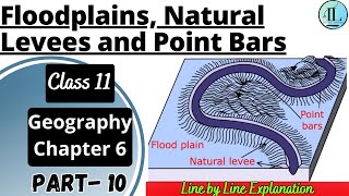
Natural levees and point bars are some of the important landforms found associated with floodplains. Natural levees are found along the banks of large rivers. They are low, linear and parallel ridges of coarse deposits along the banks of rivers, quite often cut into individual mounds.
Detailed Explanation
Natural levees are elevated banks that form alongside rivers when sediment is deposited during flooding. When a river overflows, the fastest-moving water carries larger particles which settle near the riverbank, forming levees to create elevated ridges. This process occurs repeatedly whenever floods happen.
Examples & Analogies
Consider how you might build a small barricade of sandbags to hold back water from flooding a garden. The sandbags resemble natural levees, as they catch and hold back the sediment and water, forming a raised area along the edge.
Understanding Point Bars
Chapter 4 of 5
🔒 Unlock Audio Chapter
Sign up and enroll to access the full audio experience
Chapter Content
Point bars are also known as meander bars. They are found on the concave side of meanders of large rivers and are sediments deposited in a linear fashion by flowing waters along the bank. They are almost uniform in profile and in width and contain mixed sizes of sediments.
Detailed Explanation
Point bars form on the inside curve of meanders where the flow slows down, allowing sediments to accumulate. These bars represent where the river loses energy, causing it to deposit sand and silt, thus forming new land. They often have a gentle slope leading from the river to the bar.
Examples & Analogies
Imagine a lazy river where a raft floats downstream. As it curves, the water slows on the inside bend and drops bits of sand and pebbles, forming a small sandy beach. This sandy area is like a point bar in a river.
Meander Formation
Chapter 5 of 5
🔒 Unlock Audio Chapter
Sign up and enroll to access the full audio experience
Chapter Content
In large flood and delta plains, rivers rarely flow in straight courses. Loop-like channel patterns called meanders develop over flood and delta plains.
Detailed Explanation
Meanders are sinuous curves that rivers form when they flow across flat plains. As the water flows, it erodes the outer banks where the speed is higher and deposits sediment on the inner banks, causing the river's course to bend and loop.
Examples & Analogies
Think about how a water hose might create bends on the ground when you move it around. Each curve represents how the water moves faster on the outside and slower on the inside, gradually shaping the path into meanders.
Key Concepts
-
Floodplains support rich ecosystems and agriculture.
-
Natural levees help protect against flooding but can be breached.
-
Point bars form from sediments deposited in slower moving water on river bends.
Examples & Applications
Examples of floodplains can be observed in the Mississippi River basin, where flooding creates fertile agricultural land.
Natural levees can be observed along the banks of rivers, like the Rio Grande, where they form protective barriers.
Point bars can be seen in many meandering rivers, such as the Wisconsin River, where sediment accumulates on the inside of bends.
Memory Aids
Interactive tools to help you remember key concepts
Rhymes
When rivers swell and waters rise, floodplains form, a nature surprise!
Stories
Imagine a river named Sandy that loved to meander. Every spring, when it overflowed, it left behind nutrient-rich lands called floodplains for farmers to grow crops.
Memory Tools
LEAP: Levee, Ecosystem, Agriculture, Point Bars.
Acronyms
F.A.P.
Floodplain
Agriculture
Protection by levees.
Flash Cards
Glossary
- Floodplain
A flat area adjacent to a river that is prone to flooding and deposition of sediments.
- Natural Levee
A raised bank made from sediments deposited by a river during floods.
- Point Bar
A crescent-shaped deposit of sediment on the inner side of a river meander.
Reference links
Supplementary resources to enhance your learning experience.