
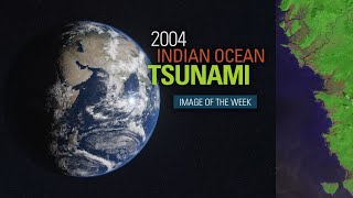
The 2004 Indian Ocean Earthquake and Tsunami
Enroll to start learning
You’ve not yet enrolled in this course. Please enroll for free to listen to audio lessons, classroom podcasts and take practice test.
Interactive Audio Lesson
Listen to a student-teacher conversation explaining the topic in a relatable way.
Location and Magnitude of the Earthquake
🔒 Unlock Audio Lesson
Sign up and enroll to listen to this audio lesson

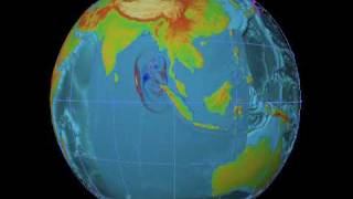
Let's start with the basics. The 2004 Indian Ocean earthquake occurred on December 26, with a magnitude between 9.1 and 9.3. Can anyone tell me where the epicenter was located?

It was off the west coast of Northern Sumatra, Indonesia.
Exactly! And do you know how deep it was?

It was about 30 kilometers deep.
Right! Remember, the shallower the earthquake, the more intense the impact can be. This earthquake caused immense vertical displacement. Why do you think that is significant?

Because it can lead to tsunamis, right?
Exactly! Tsunamis result from such movements. It is crucial to understand these factors to mitigate similar disasters in the future.
In summary, the earthquake occurred off Northern Sumatra at a depth of 30 km, which was a key factor in the subsequent tsunami.
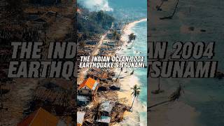
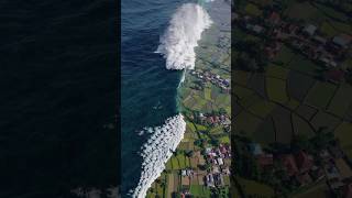
Tsunami and Its Impact
🔒 Unlock Audio Lesson
Sign up and enroll to listen to this audio lesson

After the earthquake, a massive tsunami was triggered. How many countries were affected by this disaster?

Fourteen countries were impacted.
Correct! The tsunami led to over 230,000 deaths globally, which was catastrophic. What regions were hit hardest?
Coastal areas in India, Sri Lanka, Indonesia, and Thailand.
Right! Tamil Nadu in India was particularly badly hit. What infrastructure challenges did they face due to this tsunami?
Many coastal structures, like sea walls, failed, and traditional houses were swept away.
Exactly! The failure of these structures highlights the need for resilient infrastructure. In summary, the tsunami caused immense devastation and loss of life, especially in coastal areas.
Engineering Observations and Lessons Learned
🔒 Unlock Audio Lesson
Sign up and enroll to listen to this audio lesson
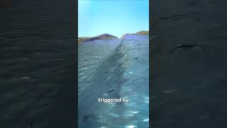
Now, let’s delve into some engineering and geological observations. What caused the earthquake?
It was due to the subduction of the Indian Plate beneath the Burma Plate.
Correct! This geophysical process led to significant displacement and triggered the tsunami. What could have minimized the casualties?
If there had been effective early warning systems, many lives could have been saved.
Absolutely! The lessons learned from this disaster emphasize the importance of implementing tsunami warning systems and creating resilient coastal planning. In closure, the tragedy of 2004 taught us critical lessons for future disaster preparedness.
Introduction & Overview
Read summaries of the section's main ideas at different levels of detail.
Quick Overview
Standard
On December 26, 2004, a powerful earthquake measuring 9.1–9.3 struck off the coast of Northern Sumatra, Indonesia, triggering a massive tsunami that resulted in over 230,000 deaths across 14 countries, particularly affecting coastal regions in India, Indonesia, Sri Lanka, and Thailand. The disaster highlighted the need for better tsunami warning systems and resilient coastal infrastructure.
Detailed
The 2004 Indian Ocean Earthquake and Tsunami
The Indian Ocean earthquake on December 26, 2004, was one of the largest earthquakes ever recorded, with a magnitude between 9.1 and 9.3. Its epicenter was located off the west coast of Northern Sumatra, Indonesia, at a depth of 30 km. The earthquake led to a devastating tsunami that affected 14 countries, claiming over 230,000 lives and causing severe destruction in coastal areas, particularly in India, Indonesia, Sri Lanka, and Thailand. Tamil Nadu in India experienced some of the worst impacts, with coastal structures failing and a complete lack of early warning systems contributing to the high casualty rates.
Engineering and Geological Observations
The earthquake was caused by the subduction of the Indian Plate beneath the Burma Plate, resulting in significant vertical displacement of the ocean floor. The failure of coastal structures, such as sea walls, and the disaster’s highlight on traditional wooden houses were significant in the aftermath. The catastrophe revealed the critical importance of implementing warning systems and the necessity for resilient infrastructure in coastal zones.
Lessons Learned
The 2004 tsunami disaster underscored the necessity for tsunami warning systems globally and highlighted the need for effective coastal planning. These lessons have shaped new strategies in building coastal resilience to mitigate future disasters.
Youtube Videos


Audio Book
Dive deep into the subject with an immersive audiobook experience.
Location and Magnitude
Chapter 1 of 4
🔒 Unlock Audio Chapter
Sign up and enroll to access the full audio experience
Chapter Content
• Date: December 26, 2004
• Magnitude: 9.1–9.3 on the Richter Scale
• Epicenter: Off the west coast of northern Sumatra, Indonesia
• Depth: 30 km
Detailed Explanation
This chunk provides critical information about the 2004 Indian Ocean earthquake which occurred on December 26, 2004. It was measured at a magnitude of 9.1 to 9.3 on the Richter Scale, making it one of the most powerful earthquakes ever recorded. The epicenter, or the point on the Earth's surface directly above where the earthquake originated, was located off the west coast of northern Sumatra, Indonesia. The earthquake occurred at a depth of 30 kilometers, which is relatively shallow, leading to severe surface shaking.
Examples & Analogies
Think of how a pebble thrown into a pond creates ripples. A shallow throw can create larger ripples closer to the edge, while a deeper throw makes smaller ripples. In earthquakes, a shallow depth often results in stronger shaking felt on the surface, similar to how a shallow pebble toss affects the pond's edge more dramatically.
Damage and Impact
Chapter 2 of 4
🔒 Unlock Audio Chapter
Sign up and enroll to access the full audio experience
Chapter Content
• Triggered a massive tsunami affecting 14 countries
• Over 230,000 deaths globally
• Severe damage in coastal areas of India, Indonesia, Sri Lanka, and Thailand
• Indian state of Tamil Nadu was one of the worst hit
Detailed Explanation
The earthquake triggered a gigantic tsunami that had disastrous effects across 14 countries, highlighting the earthquake's far-reaching impact. Tragically, the tsunami resulted in the deaths of over 230,000 people worldwide, making it one of the deadliest natural disasters in history. Coastal areas in countries such as India, Indonesia, Sri Lanka, and Thailand faced severe destruction, with Tamil Nadu in India experiencing particularly devastating effects.
Examples & Analogies
Imagine dropping a rock into multiple ponds at once, with each pond representing a country. The ripples from the rock affect not just the closest pond but also reach others, stretching far beyond the initial impact area. Similarly, the tsunami spread across several countries, reflecting the interconnectedness and vulnerability of coastal regions.
Engineering and Geological Observations
Chapter 3 of 4
🔒 Unlock Audio Chapter
Sign up and enroll to access the full audio experience
Chapter Content
• Subduction of the Indian Plate beneath the Burma Plate caused vertical displacement.
• Coastal structures like sea walls failed; traditional wooden houses were swept away.
• Lack of early warning systems was a major factor in high casualties.
Detailed Explanation
The earthquake occurred due to the subduction—where one tectonic plate moves under another—of the Indian Plate beneath the Burma Plate. This caused significant vertical displacement, resulting in immense force that not only shook the ground but also generated tsunami waves. Many coastal structures, such as sea walls, were insufficient to protect against the tsunami, leading to their failure. Furthermore, the absence of early warning systems meant that many people were caught off guard, contributing to the high casualty rate.
Examples & Analogies
Think of a game of tug-of-war where one side pulls suddenly. The ground shakes, but if one side loses their balance and falls into a puddle, they get wet. In a similar way, when tectonic plates shift abruptly, they disturb the ocean floor, leading to massive waves and flooding that could overwhelm any structures meant to resist them.
Lessons Learned
Chapter 4 of 4
🔒 Unlock Audio Chapter
Sign up and enroll to access the full audio experience
Chapter Content
• Implementation of tsunami warning systems.
• Importance of coastal planning and resilient infrastructure near coastal zones.
Detailed Explanation
The tragedy of the 2004 tsunami underscored the critical need for comprehensive tsunami warning systems that can alert populations before disaster strikes. Such systems involve monitoring seismic activities and potential tsunami waves to ensure safety. Additionally, this disaster highlighted the importance of implementing robust coastal planning and building resilient infrastructure, which would minimize damage and loss of life in future events.
Examples & Analogies
Consider how smoke detectors are installed in homes to alert families of fire dangers before it's too late. In a similar fashion, tsunami warning systems serve as an early alert, providing crucial time for coastal communities to evacuate. Furthermore, just like building stronger and safer homes to withstand a fire, we must design coastal buildings to endure natural disasters.
Key Concepts
-
Subduction of tectonic plates: The process where one tectonic plate moves under another, significant in causing earthquakes.
-
Impact of tsunamis: Understanding the catastrophic effects tsunamis can have on coastal areas.
-
Need for early warning systems: Highlighting the necessity for systems that warn coastal populations about impending tsunamis.
Examples & Applications
The 2004 tsunami affected multiple countries, showcasing the interconnectedness of global coastal regions.
The traditional wooden houses in Indonesia were particularly vulnerable, illustrating the importance of resilient building materials.
Memory Aids
Interactive tools to help you remember key concepts
Rhymes
Tsunami waves high, from the depths they cry, when plates collide, coastal lives fly.
Stories
Once upon a time, the Indian Plate was sinking under the Burma Plate. Their clash was so powerful, it shook the ocean floor and sent waves crashing onto distant shores, turning calm waters into a chaotic flood!
Memory Tools
Remember 'PLATE' for the causes of the tsunami: P for Plates (subduction), L for Lives lost (230,000), A for Areas affected (14), T for Tsunami height, and E for Early warning systems needed.
Acronyms
TWS
'Tsunami Warning Systems' for a reminder on the measures that can save lives.
Flash Cards
Glossary
- Tsunami
A series of ocean waves caused by the displacement of a large volume of water, usually due to an underwater earthquake.
- Subduction Zone
A region of the Earth's crust where one tectonic plate moves under another and sinks into the mantle.
- Epicenter
The point on the Earth's surface directly above the location where an earthquake starts.
- Magnitude
A measure of the energy released during an earthquake, often measured on the Richter scale.
Reference links
Supplementary resources to enhance your learning experience.