
METHODS FOR IMPACT IDENTIFICATION
Enroll to start learning
You’ve not yet enrolled in this course. Please enroll for free to listen to audio lessons, classroom podcasts and take practice test.
Interactive Audio Lesson
Listen to a student-teacher conversation explaining the topic in a relatable way.
Introduction to Impact Identification
🔒 Unlock Audio Lesson
Sign up and enroll to listen to this audio lesson

Let's start with understanding the purpose of impact identification in environmental assessments. Why do you think recognizing all impacts—direct and indirect—is critical?

So we can make sure we don’t miss anything important that might affect the environment?
Exactly! Missing indirect and cumulative effects could lead to significant environmental harm. This is why a logical and systematic approach is required.

What are some common methods for impact identification?
Great question! Methods such as checklists and matrices are commonly used to ensure a thorough evaluation. Let's delve into these methods in our next session.
Checklists for Impact Identification
🔒 Unlock Audio Lesson
Sign up and enroll to listen to this audio lesson

Now, let’s explore checklists. Can anyone tell me how checklists might help in identifying impacts?

They provide a systematic list of factors to consider?
Exactly! Checklists can range from simple to complex, and can include specific categories related to certain project types. Can anyone think of a project type that might require a specialized checklist?

Maybe a dam construction project? There are many environmental factors to consider there.
Good example! These sector-specific checklists ensure all relevant impacts are considered. Remember, the effectiveness of checklists can improve as we adapt them based on past experiences.
Matrices for Impact Analysis
🔒 Unlock Audio Lesson
Sign up and enroll to listen to this audio lesson
Let’s discuss matrices now! How do you think they help in impact identification?
They probably show interactions between activities and their environmental effects?
Yes! Matrices allow us to visualize these interactions in a grid format. What might be an advantage of using a visual format for analysis?
It makes it easier to understand and compare different impacts right away.
Exactly! This clarity is crucial for making informed decisions. We can use symbols or notes in the matrix cells to highlight the severity of impacts.
Networks and Cause-Effect Relationships
🔒 Unlock Audio Lesson
Sign up and enroll to listen to this audio lesson
Now let’s look at networks. How do these help in understanding impacts?
They can show the cause-and-effect relationships between project activities and environmental impacts?
Exactly! Networks are particularly good at highlighting secondary impacts that might be overlooked. Why is it important to identify these secondary impacts?
Because they can ultimately lead to significant environmental consequences that were not initially considered.
Precisely! It's crucial to consider how one action can lead to a series of impacts.
GIS and Overlays for Impact Mapping
🔒 Unlock Audio Lesson
Sign up and enroll to listen to this audio lesson
Finally, let’s talk about overlays and GIS. How can they benefit our impact identification process?
They help map impacts visually which can make decision-making easier?
Correct! They present spatial data effectively, allowing us to see how impacts may vary across different locations. What might be a downside of using GIS?
The data might not always be accurate, and it can be expensive to set up?
Yes! While GIS can be a powerful tool, challenges related to data quality and costs can limit its use. Overall, it's essential to use a combination of these methods for comprehensive impact assessment.
Introduction & Overview
Read summaries of the section's main ideas at different levels of detail.
Quick Overview
Standard
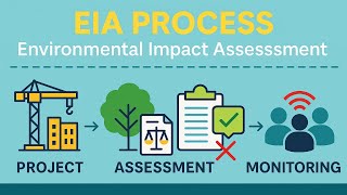
The section discusses various methodologies for impact identification in Environmental Impact Assessments (EIA), highlighting the need to understand direct, indirect, and cumulative effects. Key methods include checklists, matrices, networks, and Geographic Information Systems (GIS), each serving to systematically address environmental factors.
Detailed
Detailed Summary
Introduction
This section emphasizes the necessity of employing a logical and systematic approach for identifying environmental and project impacts. The goal is to acknowledge all important impacts and interactions, particularly those that are indirect or cumulative, ensuring no potentially significant effects are omitted.
Process
Impact identification begins during the initial screening and continues through the scoping phase, where key issues are categorized for further analysis. Various methodologies and tools have been developed over time to assist in this process.
Main Methods for Impact Identification
- Checklists: These are tools that help identify environmental features or factors that need attention during impact assessment. Their complexity can vary, and they can be tailored for specific types of projects.
- Matrices: These grids display the interactions between project activities and environmental characteristics, allowing for a structured analysis of impact severity.
- Networks: Useful for illustrating cause-effect relationships of activities and environmental factors, they help in identifying secondary impacts like indirect effects.
- Overlays and Geographic Information Systems (GIS): These methods map impacts spatially, aiding in visual analysis and decision-making regarding environmental sensitivity.
Overall, employing these methods effectively is critical for comprehensive Environmental Impact Assessments (EIA).
Youtube Videos


Audio Book
Dive deep into the subject with an immersive audiobook experience.
Introduction to Impact Identification
Chapter 1 of 7
🔒 Unlock Audio Chapter
Sign up and enroll to access the full audio experience
Chapter Content
A logical and systematic approach needs to be taken to impact identification. The aim is to take account of all of the important environmental/project impacts and interactions, making sure that indirect and cumulative effects, which may be potentially significant, are not inadvertently omitted.
Detailed Explanation
Impact identification is crucial for understanding how a project affects the environment. This means looking not just at the obvious impacts but also at those that might not be immediately evident, such as indirect contributions and the cumulative effects over time. For instance, building a road may directly affect land use, but it may also indirectly lead to increased pollution through traffic or habitat destruction nearby. Therefore, a thorough approach ensures that all possible impacts are considered and addressed.
Examples & Analogies
Imagine you're planning to build a new shopping center in a town. You might think about how it impacts the land it's on (a direct impact) and forget to consider things like increased traffic leading to noise and air pollution or how it might change the character of local neighborhoods (indirect impacts). A systematic approach helps you catch these aspects before the project begins.
Impact Identification Process
Chapter 2 of 7
🔒 Unlock Audio Chapter
Sign up and enroll to access the full audio experience
Chapter Content
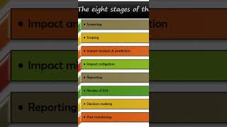
This process begins during screening and continues through scoping, which identifies the key issues and classifies them into impact categories for further study. In the next phase, the likely impacts are analyzed in greater detail in accordance with terms of reference specifically established for this purpose.
Detailed Explanation
The impact identification process consists of several phases. It starts with 'screening,' where broad potential impacts are considered. After screening, 'scoping' helps to focus on the most critical issues by categorizing them, which means organizing them based on their type or area of effect. Subsequently, in-depth analysis examines these identified impacts in detail to determine their significance and how they can be managed or mitigated.
Examples & Analogies
Think of it like planning a school science fair. First, you might brainstorm all the possible projects (screening). Then, you would select the most exciting and feasible ones (scoping) that fit within time and resource limits. After that, you'd flesh out each project, listing all materials needed and steps to succeed (detailed analysis).
Common Methods for Impact Identification
Chapter 3 of 7
🔒 Unlock Audio Chapter
Sign up and enroll to access the full audio experience
Chapter Content
The most common formal methods used for impact identification are: • Checklists; • Matrices; • Networks; • Overlays and geographic information systems (GIS).
Detailed Explanation
Various methods exist for identifying impacts, each offering distinct advantages. Checklists standardize the identification process by listing critical environmental factors to consider. Matrices visually map out interactions between project activities and environmental aspects, helping to highlight potential issues. Networks provide a more in-depth view of cause-effect relationships, particularly for secondary impacts. Lastly, overlays and GIS allow for a spatial representation of data, enabling easy visualization of geographic impacts.
Examples & Analogies
Imagine trying to figure out how a new park will impact a local area. A checklist might remind you to consider wildlife, water sources, and community needs. A matrix could help you track how different activities like playground installation or picnic areas affect noise levels and traffic. A network could show how building a park might also influence nearby businesses by increasing customer foot traffic. GIS could provide maps that show what part of the neighborhood gains the most benefit from the park.
Using Checklists for Impact Identification
Chapter 4 of 7
🔒 Unlock Audio Chapter
Sign up and enroll to access the full audio experience
Chapter Content
Checklists annotate the environmental features or factors that need to be addressed when identifying the impacts of projects and activities. They can vary in complexity and purpose, from a simple checklist to a structured methodology or system that also assigns significance by scaling and weighting the impacts.
Detailed Explanation
Checklists serve as a comprehensive tool to ensure that all necessary environmental factors are considered in project planning. They can help streamline the identification process and can be very flexible, adapting to local conditions and specific project types. For instance, different types of construction projects may have distinct checklists tailored to their specific risks and impacts.
Examples & Analogies
Consider a doctor using a checklist before performing surgery. The list ensures that no important step is overlooked, such as confirming the patient's identity or checking that the surgical tools are sterile. Similarly, an environmental checklist ensures that every potential impact is thought through before a project goes ahead.
Impact Identification with Matrices
Chapter 5 of 7
🔒 Unlock Audio Chapter
Sign up and enroll to access the full audio experience
Chapter Content
A matrix is a grid-like table used to identify the interaction between project activities, which are displayed along one axis, and environmental characteristics, which are displayed along the other axis.
Detailed Explanation
Matrices visually represent the interactions between project activities and environmental characteristics. By filling in cells where these factors intersect, stakeholders can quickly see where impacts might occur. This method can illustrate the severity of impacts using different symbols or comments to enhance understanding.
Examples & Analogies
Think of a restaurant menu as a matrix. The dishes are listed on one axis and the types of ingredients on the other. This way, you can easily see which dishes contain specific ingredients, helping customers with allergies choose their meals safely.
Networks in Impact Identification
Chapter 6 of 7
🔒 Unlock Audio Chapter
Sign up and enroll to access the full audio experience
Chapter Content
Networks illustrate the cause-effect relationship of project activities and environmental characteristics. They are particularly useful in identifying and depicting secondary impacts.
Detailed Explanation
Networks help visualize complex relationships between project activities and their impacts on the environment, particularly highlighting secondary or indirect effects. These illustrations can help teams understand how one element of a project impacts another, making it easier to identify potential risks.
Examples & Analogies
Consider a spider web, where each thread connects different areas. If one thread (like a new highway) is tugged on (meaning the highway is built), it can affect the entire web (the local ecosystem), possibly leading to changes elsewhere, similar to how a project's activities might lead to unforeseen consequences elsewhere.
Overlays and Geographic Information Systems (GIS)
Chapter 7 of 7
🔒 Unlock Audio Chapter
Sign up and enroll to access the full audio experience
Chapter Content
Overlays can be used to map impacts spatially and display them pictorially. The original overlay technique is an environmental suitability analysis in which data on topographic features, ecological values and resource constraints are mapped onto individual transparencies.
Detailed Explanation
Overlays and GIS technologies allow for the spatial visualization of environmental impacts. This helps in comparing different project sites and planning alternatives by providing a layered view of various ecological factors. While traditionally useful, modern GIS capabilities enhance these analyses, enabling detailed assessments of areas potentially affected by projects.
Examples & Analogies
Imagine a treasure map. Each layer of the map—like mountains, rivers, and roads—can be overlaid to see not just where the treasure is but also what obstacles might be in the way. Similarly, GIS helps planners see how different environmental features might interact with a new project site.
Key Concepts
-
Systematic Approach: Refers to a logical and organized method for identifying environmental impacts.
-
Direct and Indirect Impacts: Direct impacts are immediate effects, while indirect impacts are secondary consequences of a project.
-
Checklists: Tools used for identifying environmental factors during impact assessments.
-
Matrices: Grids used for visualizing interactions between project activities and environmental characteristics.
-
Networks: Visual tools illustrating cause-effect relationships among project activities and impacts.
-
GIS: Technology used for mapping and analyzing spatial data in environmental assessments.
Examples & Applications
A checklist used for assessing impacts on water quality when constructing a new road.
A matrix displaying the interactions between different construction activities and their potential effects on local wildlife.
A network diagram that maps out how land clearing can lead to soil erosion, which then contributes to water pollution.
Memory Aids
Interactive tools to help you remember key concepts
Rhymes
For any project, big or small, checklists help us catch them all!
Stories
Imagine a project manager embarking on a construction site. With her trusty checklist in hand, she ensures every potential environmental impact is noted, preventing potential harm.
Memory Tools
To remember the four methods of impact identification, think 'C-MENG': Checklists, Matrices, Networks, and GIS.
Acronyms
Use 'C-GNIM'
Checklists-GIS-Networks-Impact-Matrices for quick recall.
Flash Cards
Glossary
- Impact Identification
The process of recognizing and assessing potential environmental effects resulting from a project or proposal.
- EIA (Environmental Impact Assessment)
A systematic process to evaluate the environmental consequences of a proposed project before it is carried out.
- Checklists
Tools that help identify important environmental factors to consider during the assessment process.
- Matrices
Grid-like tables used to display interactions between project activities and environmental characteristics.
- Networks
Visual representations of cause and effect relationships among various factors involved in an impact assessment.
- GIS (Geographic Information Systems)
Computer systems for capturing, storing, managing, and analyzing spatial or geographic data to visualize environmental impacts.
Reference links
Supplementary resources to enhance your learning experience.