
Data Processing and Coordinate Systems
Enroll to start learning
You’ve not yet enrolled in this course. Please enroll for free to listen to audio lessons, classroom podcasts and take practice test.
Interactive Audio Lesson
Listen to a student-teacher conversation explaining the topic in a relatable way.
Raw Data Processing
🔒 Unlock Audio Lesson
Sign up and enroll to listen to this audio lesson

Today, we are going to learn about raw data processing in surveying. Can anyone tell me what types of raw data are generated from Total Stations and GPS?

It includes angles, distances, time stamps, and satellite positions.
Exactly! This raw data must be processed to convert it into geographic coordinates. We use specialized software tools like Leica Geo Office or ArcGIS for this purpose. Can anyone think of why this step is necessary?

To make sure the data is usable for mapping and analysis.
Right! Without processing, the data would just be numbers without meaningful interpretations. This step ensures our work is reliable. Remember, 'Processing leads to Precision'—a great way to remember this concept!
Coordinate Systems
🔒 Unlock Audio Lesson
Sign up and enroll to listen to this audio lesson

Next, let's talk about coordinate systems. Why do you think they are important in surveying?

They help in accurately placing data on a map, right?
Absolutely! Commonly used systems include UTM and WGS 84. Each system has a specific way of referencing Earth's surface. Can anyone explain what might happen if we use the wrong coordinate system?

Our data could end up in the wrong location on the map, causing errors in analysis and planning.
Exactly! That’s a critical point. Always ensure you know which system your data is being processed in. A quick acronym to remember is 'UGL'—Understand, Georeference, Locate.
Datum and Projection Considerations
🔒 Unlock Audio Lesson
Sign up and enroll to listen to this audio lesson
Lastly, let’s discuss datum and projection considerations. Who can tell me what a datum is?
It's the reference point or surface from which measurements are made.
Correct! Examples of datums include WGS84 and NAD83. Now, what about map projections?
Map projections transform the Earth's curved surface into a flat map.
Great information! Remember, when transitioning between various data inputs, understanding both the datum and the projection is crucial, especially when integrating datasets from different sources. Think of it this way: 'Perfect Transitions Require Datum Attention!'
Introduction & Overview
Read summaries of the section's main ideas at different levels of detail.
Quick Overview
Standard
In this section, we explore the significance of processing raw data from Total Stations and GPS to create usable geographic coordinates. We also examine various coordinate systems and their transformations, along with the considerations for datums and map projections essential in surveying.
Detailed
Data Processing and Coordinate Systems
Data processing is a fundamental step in surveying that involves converting raw data collected from Total Stations and GPS into meaningful geographic coordinates. The raw data includes angles, distances, time stamps, and satellite positions that must be processed using sophisticated surveying software such as Leica Geo Office, Trimble Business Center, AutoCAD Civil 3D, and ArcGIS/ArcMap.
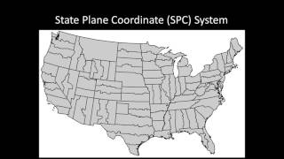
In order to maintain geospatial consistency, survey data needs to be referenced to a coordinate system. Commonly used systems include UTM (Universal Transverse Mercator), WGS 84 (World Geodetic System 1984), and local state plane or arbitrary coordinate systems. Transformations between these coordinate systems are often necessary when integrating data from various sources like GPS and Total Station.
Furthermore, understanding datum and projection considerations—such as the reference points or surfaces for measurements and the methods for transforming the Earth's curved surface to a flat map—is crucial for the accuracy and reliability of the data. Examples of commonly used datums include WGS84 and NAD83, while popular map projections include UTM and Lambert Conformal Conic.
Youtube Videos


Audio Book
Dive deep into the subject with an immersive audiobook experience.
Raw Data Processing
Chapter 1 of 3
🔒 Unlock Audio Chapter
Sign up and enroll to access the full audio experience
Chapter Content
Both Total Station and GPS generate raw data (angles, distances, time stamps, satellite positions, etc.) which must be processed into meaningful geographic coordinates. This is done using surveying software like:
• Leica Geo Office
• Trimble Business Center
• AutoCAD Civil 3D
• ArcGIS/ArcMap
Detailed Explanation
When survey instruments like Total Stations and GPS collect data, they produce raw numbers that describe various measurements, such as angles and distances. To make sense of this data and convert it into usable geographic coordinates, specialized software is employed. Examples of such software include Leica Geo Office, Trimble Business Center, AutoCAD Civil 3D, and ArcGIS. These tools help in manipulating the raw data to derive meaningful geographic information that can be used for mapping, analysis, and project planning.
Examples & Analogies
Imagine taking a photograph with a digital camera. The camera captures lots of raw data, like color, light intensity, and dimensions of the scene. However, just as you would edit that photo with software to enhance colors and crop it for presentation, surveyors use software to process their raw data into clear and useful maps or models.
Coordinate Systems and Transformations
Chapter 2 of 3
🔒 Unlock Audio Chapter
Sign up and enroll to access the full audio experience
Chapter Content
Survey data needs to be referenced to a coordinate system for geospatial consistency. Common systems used include:
• UTM (Universal Transverse Mercator)
• WGS 84 (World Geodetic System 1984)
• Local State Plane or Arbitrary Coordinate Systems
Transformation between coordinate systems is necessary when integrating data from GPS and Total Station.
Detailed Explanation
When surveyors collect data, it is crucial to place that data within a specific coordinate system to ensure that it makes sense in relation to the Earth's surface. Coordinate systems like UTM and WGS 84 are internationally recognized standards that help in accurately locating points on the globe. Additionally, surveyors may need to convert or transform data between different coordinate systems, especially when integrating data from various sources like Total Stations and GPS. This step ensures that all data is compatible and can be accurately compared and analyzed.
Examples & Analogies
Think of coordinate systems like languages. If you want to communicate with someone, both parties need to speak the same language to understand each other. Likewise, if survey data is collected in different coordinate systems, it is like speaking different languages—transforming the data into a common coordinate system is necessary for clear communication and accurate interpretation.
Datum and Projection Considerations
Chapter 3 of 3
🔒 Unlock Audio Chapter
Sign up and enroll to access the full audio experience
Chapter Content
• Datum: A reference point or surface from which measurements are made (e.g., WGS84, NAD83).
• Map Projections: Transforming the curved Earth surface to a flat map (e.g., UTM, Lambert Conformal Conic).
Proper understanding of datum shifts and projection parameters is essential when integrating datasets from multiple sources.
Detailed Explanation
A datum is essentially a reference point or a model of the Earth we use for measuring locations. Examples include WGS84 and NAD83, which help define how we calculate coordinates. Map projections, on the other hand, are methods used to translate the three-dimensional shape of the Earth onto a two-dimensional plane, like a map. Different projection methods may distort some aspects of the Earth (like area or shape) to preserve others. A thorough understanding of how these datums and projections work is important when combining data from various surveying methods as it ensures accuracy and consistency.
Examples & Analogies
Imagine trying to peel an orange and lay it flat—different ways of peeling (like slicing or dicing) will present the orange in various flattened forms, but none will capture the original shape perfectly. Similarly, map projections allow us to represent the Earth's curved surface on flat maps, but each projection comes with its own type of distortion, akin to those different peeling methods.
Key Concepts
-
Data Processing: Converting raw survey data into geographic coordinates using software tools.
-
Coordinate Systems: Systems required for referencing data accurately on Earth's surface.
-
Datum: Reference points essential for accurate measurement in surveying.
-
Map Projections: Techniques to represent the Earth's curved surface in a flat format.
Examples & Applications
Using UTM coordinates to locate survey data on a regional map.
Converting GPS data from WGS 84 to a local state plane coordinate system for construction layout.
Memory Aids
Interactive tools to help you remember key concepts
Rhymes
To keep your data neat, always process with a treat; coordinates you'll meet, in a system that's sweet!
Stories
Imagine a land surveyor lost in the woods, trying to find a path without a map. They remember their training: ‘Without proper datum and projection, my data can't find direction.’ So they pull out their tools, process their data, and chart their way out using coordinate systems.
Memory Tools
Remember the mnemonic 'PDC': Processing Data with Coordinates requires Datums.
Acronyms
Use the acronym 'GPC' - Geographic Coordinates Processing.
Flash Cards
Glossary
- Raw Data Processing
The process of converting raw survey data into meaningful geographic coordinates using surveying software.
- Coordinate System
A system used to reference points on the Earth's surface to ensure accurate placement of data.
- Datum
A reference point or surface from which measurements are made in surveying.
- Map Projection
A method for transforming the curved surface of the Earth into a flat map.
Reference links
Supplementary resources to enhance your learning experience.