
GPS Surveying
Enroll to start learning
You’ve not yet enrolled in this course. Please enroll for free to listen to audio lessons, classroom podcasts and take practice test.
Interactive Audio Lesson
Listen to a student-teacher conversation explaining the topic in a relatable way.
Overview of GPS
🔒 Unlock Audio Lesson
Sign up and enroll to listen to this audio lesson

Today, we will discuss the Global Positioning System, commonly known as GPS. Can anyone tell me what GPS stands for?

Global Positioning System!
Correct! GPS is a satellite-based navigation system that provides location and time information. It's essential in modern surveying. What do you think its advantages might be?

It can be used almost anywhere on Earth!

And it probably works in many weather conditions!
Absolutely, GPS offers global coverage and high accuracy. It's capable of functioning in various weather conditions, which is a huge advantage in surveying. Does anyone know how GPS determines your location?

I think it uses satellites?
Spot on! GPS receivers calculate their position based on signals from at least four satellites using a method called trilateration. This is a critical concept in understanding how GPS works! Remember the term 'trilateration' as it’s fundamental!
In summary, GPS is a revolutionary tool in surveying due to its global applicability and accuracy, significantly enhancing the efficiency and precision of geospatial data collection.
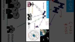
Components of GPS
🔒 Unlock Audio Lesson
Sign up and enroll to listen to this audio lesson

Next, let's break down the components of GPS. Do you all remember the three segments of GPS?
There's the space segment with the satellites!
And then the control segment with ground stations!
And the user segment with our GPS receivers!
"Exactly! The GPS system consists of:
Types of GPS Surveying
🔒 Unlock Audio Lesson
Sign up and enroll to listen to this audio lesson
Now, let's discuss the different types of GPS surveying methods. Can anyone recall a few types?
I've heard of Static GPS Surveying!
And Kinematic GPS Surveying!
"Great! We have:
Sources of GPS Errors
🔒 Unlock Audio Lesson
Sign up and enroll to listen to this audio lesson
Finally, let's address the sources of GPS error. What do you think could affect GPS accuracy?
Maybe atmospheric effects like the ionosphere?
Or if there are obstacles blocking the satellite signals, like buildings?
"Absolutely right! Key sources of GPS error include the ionospheric and tropospheric delays, satellite clock errors, multipath effects, receiver noise, and orbital errors.
Applications of GPS Surveying
🔒 Unlock Audio Lesson
Sign up and enroll to listen to this audio lesson
As we conclude, let's explore the practical applications of GPS surveying. Who can share some fields where GPS is utilized?
It’s used in construction to survey land!
And for mapping in geospatial sciences!
"Correct! GPS plays a vital role in:
Introduction & Overview
Read summaries of the section's main ideas at different levels of detail.
Quick Overview
Standard
Global Positioning System (GPS) surveying leverages a constellation of satellites, ground control stations, and user receivers to determine precise geographical locations. This section outlines the components, principles, methodologies, and limitations associated with GPS surveying, demonstrating its importance in civil engineering and geospatial tasks.
Detailed
Detailed Summary
GPS Surveying is a vital aspect of modern surveying that leverages satellite technology to provide precise location data anywhere on Earth. The system comprises three main components:
- Space Segment: A network of at least 24 satellites that orbit the Earth.
- Control Segment: Ground-based stations tasked with monitoring and managing the satellites.
- User Segment: GPS receivers that collect satellite signals to compute position, velocity, and time.
The operation of GPS is based on trilateration, which requires signals from at least four satellites. By measuring the time taken for signals to reach the receiver, distances can be calculated, thus determining the receiver's location.
Different types of GPS surveying techniques exist, including Static, Kinematic, Real-Time Kinematic (RTK), and Differential GPS (DGPS), each suitable for various applications ranging from high accuracy projects to mobile surveying.
However, GPS surveying also comes with challenges such as susceptibility to environmental factors causing errors, the necessity for a clear line of sight to satellites, and varying levels of accuracy based on the equipment used. The advantages of GPS include global coverage, ease of use, and the ability to operate under diverse weather conditions, making it a key tool in civil engineering and geospatial endeavors.
Youtube Videos


Audio Book
Dive deep into the subject with an immersive audiobook experience.
Overview of GPS
Chapter 1 of 8
🔒 Unlock Audio Chapter
Sign up and enroll to access the full audio experience
Chapter Content
The Global Positioning System (GPS) is a satellite-based navigation system that provides geolocation and time information anywhere on Earth. It is a vital tool for high-precision geospatial positioning in surveying.
Detailed Explanation
GPS is essentially a technology that uses satellites orbiting the Earth to provide precise location information. By receiving signals from these satellites, GPS devices can determine their location anywhere on the planet. This capability is crucial in surveying because it allows surveyors to accurately pinpoint locations without the need for traditional ground markers.
Examples & Analogies
Think of GPS as a global treasure map. Just like a treasure hunter uses a map to find exact locations, a surveyor uses GPS to locate specific points on the Earth, but instead of X marks the spot, they rely on signals from satellites above to find the exact coordinates.
Components of GPS
Chapter 2 of 8
🔒 Unlock Audio Chapter
Sign up and enroll to access the full audio experience
Chapter Content
• Space Segment: Consists of at least 24 satellites orbiting the Earth.
• Control Segment: Ground-based stations that monitor, manage, and control satellite operations.
• User Segment: GPS receivers used to collect signals and compute position, velocity, and time.
Detailed Explanation
GPS is made up of three main components. The space segment consists of satellites that continuously orbit the Earth, broadcasting signals. The control segment consists of ground stations that track these satellites and ensure they are functioning correctly. Finally, the user segment includes devices such as smartphones and dedicated GPS receivers that interpret these signals to provide location information.
Examples & Analogies
Imagine GPS as a three-part teamwork project. The satellites are like team members who gather all the information from up high, the ground stations are like the project managers keeping everything on track, and the GPS receiver is a team member who interprets and uses the gathered data to make decisions about directions or locations.
Principles of GPS Operation
Chapter 3 of 8
🔒 Unlock Audio Chapter
Sign up and enroll to access the full audio experience
Chapter Content
GPS works by calculating the distance between the receiver and multiple satellites. Using trilateration, the position is determined by knowing:
• The location of at least 4 satellites.
• The time it takes for the satellite signals to reach the receiver.
Detailed Explanation
The process of determining a position using GPS involves a method called trilateration. By measuring how far a GPS receiver is from at least four satellites, it can pinpoint its exact location. Each distance measurement creates a sphere around each satellite, and where these spheres intersect defines the receiver's position in three dimensions.
Examples & Analogies
Think of trilateration like determining your location in a park using landmarks. If you know you are a certain distance from the fountain, the entrance, and the statue, you can figure out exactly where you are by understanding how those landmarks relate to one another.
Types of GPS Surveying
Chapter 4 of 8
🔒 Unlock Audio Chapter
Sign up and enroll to access the full audio experience
Chapter Content
- Static GPS Surveying
• Requires long observation times.
• Used for control surveys and high-accuracy applications.
• Involves two or more receivers at known and unknown points. - Kinematic GPS Surveying
• Suitable for moving platforms.
• Faster data collection but slightly less accurate than static. - Real-Time Kinematic (RTK) Surveying
• Provides real-time correction via a base station.
• Accuracy up to centimeter level.
• Requires continuous communication (radio or cellular). - Differential GPS (DGPS)
• Utilizes a fixed base station with known coordinates.
• Base station transmits correction signals to the rover GPS unit.
• Used in hydrographic and GIS applications.
Detailed Explanation
There are several methods for conducting GPS surveying, each suited for particular scenarios. Static GPS surveying is the most accurate but time-consuming. Kinematic GPS is faster and works well when surveying moving areas. Real-Time Kinematic (RTK) surveying offers high precision and immediate corrections but needs constant connectivity. Finally, Differential GPS (DGPS) enhances accuracy by using a base station to send correction signals to the mobile receiver.
Examples & Analogies
Selecting a type of GPS surveying method is like choosing a mode of transportation for a journey. If you want to reach a destination quickly and don't need to be super precise, you might take a bus (kinematic GPS). But if you need to arrive at an exact spot, like a school’s front door, you may choose to walk straight to it (static GPS).
Sources of GPS Error
Chapter 5 of 8
🔒 Unlock Audio Chapter
Sign up and enroll to access the full audio experience
Chapter Content
• Ionospheric and tropospheric delay
• Satellite clock errors
• Multipath effects
• Receiver noise
• Orbital errors (ephemeris)
Detailed Explanation
While GPS is generally accurate, it can be affected by several error sources. Ionospheric and tropospheric delays occur when signals travel through different atmospheric layers. Satellite clock errors impact the time it takes a signal to reach the receiver. Multipath effects result when signals bounce off structures before reaching the GPS device, while receiver noise can interfere with signal clarity. Lastly, orbital errors can arise from inaccuracies in satellite position data.
Examples & Analogies
Consider using GPS like a conversation in a crowded room. Sometimes, noises from other conversations (receiver noise) or someone speaking loudly nearby (multipath effects) can distort the message you’re trying to hear, making it harder to understand exactly where to go.
GPS Accuracy and Precision
Chapter 6 of 8
🔒 Unlock Audio Chapter
Sign up and enroll to access the full audio experience
Chapter Content
GPS accuracy varies based on:
• Type of equipment (survey-grade vs. navigation-grade)
• Observation time
• Number and geometry of satellites (PDOP)
• Use of correction techniques (RTK/DGPS)
Detailed Explanation
The accuracy of GPS measurements can differ significantly depending on the equipment used and external conditions. Survey-grade tools offer more precision than regular navigation-grade devices. How long you observe the satellites also affects accuracy, as does the number and arrangement of satellites in view. Implementing correction techniques like RTK or DGPS can further enhance accuracy by adjusting for known errors.
Examples & Analogies
Imagine trying to hear a conversation from a distance. If you have high-quality hearing aids (survey-grade equipment) and someone repeats things clearly (correction techniques), you’ll have a much better understanding than if you were trying to hear without any help (navigation-grade equipment).
Advantages of GPS in Surveying
Chapter 7 of 8
🔒 Unlock Audio Chapter
Sign up and enroll to access the full audio experience
Chapter Content
• Global coverage and availability.
• Operable in any weather condition.
• High accuracy with proper techniques.
• Faster data collection and processing.
• Reduces manpower and logistics.
Detailed Explanation
GPS offers several significant advantages in surveying. It works almost anywhere on Earth, regardless of weather conditions. With the right methods, it can provide highly accurate positions quickly, which saves time and reduces the need for numerous personnel in the field.
Examples & Analogies
Using GPS in surveying is like using a smartphone for navigation. It allows you to find the fastest route to your destination without needing a printed map or asking for directions. Just as a smartphone makes traveling easier and quicker, GPS streamlines surveying processes by providing immediate and accurate location data.
Limitations of GPS Surveying
Chapter 8 of 8
🔒 Unlock Audio Chapter
Sign up and enroll to access the full audio experience
Chapter Content
• Signal obstructions in urban canyons or forests.
• Vulnerable to multipath errors.
• Requires visibility of a minimum number of satellites.
• Dependence on battery and communication for RTK.
Detailed Explanation
Despite its advantages, GPS surveying has limitations. It can struggle in areas with tall buildings or dense trees that obstruct signals. Multipath errors can also confuse measurements. Accurate readings depend on being able to 'see' a minimum number of satellites. Additionally, techniques that enhance accuracy, like RTK, require reliable battery power and communication methods.
Examples & Analogies
Think of GPS signal limitations as trying to find a friend in a crowded concert. If you’re surrounded by tall people (signal obstructions), it can be hard to see where your friend is. Also, if the phone's battery dies (dependence on battery), you can’t use the GPS anymore to guide you.
Key Concepts
-
GPS: A satellite-based navigation system.
-
Trilateration: The method used for determining positions based on satellite signals.
-
Static Surveying: A methodology requiring long observation periods for high precision.
-
Kinematic Surveying: A technique for obtaining positional data while in motion.
-
RTK: Provides real-time corrections for enhanced accuracy in surveying.
-
Differential GPS: Utilizes a base station to improve accuracy of positioning.
-
Sources of GPS Errors: Environmental or technological factors that affect GPS accuracy.
Examples & Applications
Using GPS in construction to survey and mark precise locations for new buildings.
Implementing RTK surveying to achieve centimeter-level accuracy in agricultural field mapping.
Memory Aids
Interactive tools to help you remember key concepts
Rhymes
GPS in the sky, where satellites fly, telling us where, with signals so spry!
Stories
Imagine a group of travelers across a vast desert, using GPS to find their way. They rely on satellites above, like guiding stars, ensuring they don’t lose direction and reach their destination safely.
Memory Tools
Remember the types of GPS surveying with the acronym 'SKIRD' (Static, Kinematic, RTK, Differential).
Acronyms
GPS
General Positioning System (to think of as a universal navigation tool).
Flash Cards
Glossary
- GPS
Global Positioning System, a satellite-based navigation system providing location and time information.
- Satellites
Space objects in orbit that transmit signals to GPS receivers for location determination.
- Trilateration
A method used to determine the position of a point by measuring distances from multiple known locations.
- Static Surveying
A GPS surveying method requiring long observation periods, typically used for high-accuracy applications.
- Kinematic Surveying
A method of GPS surveying suitable for moving platforms, allowing for faster data collection.
- RTK
Real-Time Kinematic surveying, providing real-time corrections for high accuracy.
- DGPS
Differential GPS, using fixed base stations to transmit correction signals to enhance accuracy.
- Multipath Effects
Errors that occur when GPS signals bounce off surfaces before reaching the receiver, leading to inaccurate measurements.
Reference links
Supplementary resources to enhance your learning experience.