
Mechanisms of Precipitation Formation
Enroll to start learning
You’ve not yet enrolled in this course. Please enroll for free to listen to audio lessons, classroom podcasts and take practice test.
Interactive Audio Lesson
Listen to a student-teacher conversation explaining the topic in a relatable way.
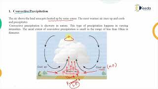
Convectional Precipitation
🔒 Unlock Audio Lesson
Sign up and enroll to listen to this audio lesson

Today, we're going to learn about convectional precipitation. Can anyone tell me how this process works?

Is it when the ground heats the air above it?
Exactly! The ground heats up, causing the warm air to rise and cool, leading to condensation. We can remember this as 'Heat Rises, Rain Falls.'

So, this leads to thunderstorms too?
That's correct! Convectional precipitation is often intense and associated with storms. Can anyone think of where we might see this?

In tropical areas, right?
Exactly! Warm climates are highly prone to this phenomenon. Great discussion!
Orographic Precipitation
🔒 Unlock Audio Lesson
Sign up and enroll to listen to this audio lesson

Next, let's talk about orographic precipitation. What happens when moist air encounters a mountain?

It gets pushed up.
Right! And as it rises, it cools and condenses. What do we call the dry area on the leeward side?
The rain shadow effect!
Yes! This is really important in hilly areas. Why do you think this matters for engineers and hydrologists?
It affects where we can build and how much water is available!
Exactly! Well done!
Cyclonic Precipitation
🔒 Unlock Audio Lesson
Sign up and enroll to listen to this audio lesson
Finally, let’s explore cyclonic precipitation. What initiates this type of rainfall?
It happens when warm air rises over cold air, right?
That's correct! This often occurs in temperate regions. Can anyone give me an example of when this might occur?
During monsoons?
Yes! Great connection. Remember, the interaction of air masses can lead to heavy rainfall. So, when we model rainfall predictions, understanding these mechanisms is essential!
Introduction & Overview
Read summaries of the section's main ideas at different levels of detail.
Quick Overview
Standard
Precipitation formation is influenced by three main mechanisms: convectional precipitation, which arises from solar heating; orographic precipitation, caused by moist air rising over mountains; and cyclonic precipitation, which occurs from colliding air masses. Understanding these mechanisms is crucial for hydrological studies and weather predictions.
Detailed
Mechanisms of Precipitation Formation
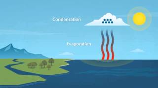
Precipitation is a vital element of the Earth's hydrological cycle, forming through three primary mechanisms:
1. Convectional Precipitation
- Definition: This type of precipitation is generated when the ground heats the air above it, causing that air to rise and cool. As the air rises, it undergoes adiabatic cooling, which results in condensation and eventually precipitation.
- Characteristics: Convectional precipitation is typically intense but of short duration and is often associated with thunderstorms.
- Occurrence: Predominantly observed in tropical regions where solar heating is more pronounced.
2. Orographic Precipitation
- Definition: Orographic precipitation occurs when moist air ascends over a mountain range. As the air rises, it cools, leading to condensation and precipitation on the windward side of the mountain.
- Rain Shadow Effect: The area on the leeward side often experiences drier conditions, creating a rain shadow.
- Importance: This mechanism is crucial in hilly and mountainous terrains, significantly influencing local climates.
3. Cyclonic (Frontal) Precipitation
- Definition: Cyclonic precipitation results from the interaction between air masses of different temperatures and densities. Warm air is pushed upward over cold air, leading to condensation and precipitation.
- Common Occurrences: This type of precipitation is typical in temperate regions and is prevalent during monsoon seasons.
Understanding these mechanisms is important for professionals in hydrology, meteorology, and environmental engineering, as they directly tie into flood forecasting, water resource management, and infrastructure design.
Youtube Videos


Audio Book
Dive deep into the subject with an immersive audiobook experience.
Convectional Precipitation
Chapter 1 of 3
🔒 Unlock Audio Chapter
Sign up and enroll to access the full audio experience
Chapter Content
4.5.1 Convectional Precipitation
• Process: Due to solar heating, the ground heats the air above, which rises, cools adiabatically, and condenses.
• Common in: Tropical regions.
• Characteristics:
– Intense, short duration.
– Associated with thunderstorms.
Detailed Explanation
Convectional precipitation occurs when the ground is heated by the sun, which in turn warms the air above it. This warm air rises due to its lower density, and as it ascends, it begins to cool. As the temperature drops, the air cannot hold as much moisture, so the water vapor condenses into droplets, forming clouds and precipitation. This type is characteristic of tropical areas and typically leads to heavy, short bursts of rain often seen in thunderstorms.
Examples & Analogies
Imagine standing outside on a hot day: as the ground gets warmer, the air above it starts to rise. Just like how a hot air balloon rises, this warm air creates updrafts. As it rises high enough, the cool air starts to squeeze the moisture out of the air, leading to sudden rain showers, similar to how a sponge releases water when you squeeze it.
Orographic Precipitation
Chapter 2 of 3
🔒 Unlock Audio Chapter
Sign up and enroll to access the full audio experience
Chapter Content
4.5.2 Orographic Precipitation
• Process: Moist air is lifted as it passes over a mountain range.
• Lifting: Causes cooling and condensation on windward side.
• Leeward Side: Often dry (Rain shadow effect).
• Important in: Hilly and mountainous terrains.
Detailed Explanation
Orographic precipitation occurs when moist air flows towards a mountain range. As the air encounters the mountain, it is forced to rise. This upward movement cools the air, which causes the water vapor to condense into clouds and eventually fall as precipitation on the windward side of the mountains. However, the air loses much of its moisture while rising, resulting in a drier climate on the leeward side, known as a rain shadow.
Examples & Analogies
Think of a sponge (moist air) being pushed over a mountain (the mountain range). As the sponge is squeezed, it releases water (rain) on one side (the windward side), but after it passes over the mountain, the sponge is now dry (little to no rain on the leeward side). Places like the Sierra Nevada mountains in California experience this effect.
Cyclonic (Frontal) Precipitation
Chapter 3 of 3
🔒 Unlock Audio Chapter
Sign up and enroll to access the full audio experience
Chapter Content
4.5.3 Cyclonic (Frontal) Precipitation
• Process: Occurs due to the movement of air masses of different temperatures and densities.
• Warm air rises over cold air, leading to condensation and precipitation.
• Common in: Temperate regions and during monsoons.
Detailed Explanation
Cyclonic or frontal precipitation happens when two different air masses come together—one warmer and one cooler. The warm, less dense air rises over the cold, denser air. As it rises, it cools and can no longer hold all its moisture, resulting in condensation and precipitation. This process is often associated with mid-latitude storms and is common in temperate areas, as well as during monsoon seasons.
Examples & Analogies
Imagine a traffic jam where two lanes of cars (air masses) meet at a bottleneck (surface). The cars in the warm lane (warm air) have to go over the cars in the cold lane (cold air) to continue moving. As they push higher (rise), they eventually pile up and have to let out some of their ‘excess’ (moisture) as they move along, resulting in rain.
Key Concepts
-
Convectional Precipitation: Generated by ground-heated air rising, cooling, and condensing.
-
Orographic Precipitation: Occurs when moist air rises over mountains, causing condensation.
-
Cyclonic Precipitation: Caused by the interaction of warm and cold air masses leading to rainfall.
Examples & Applications
A thunderstorm results from convectional precipitation due to intense solar heating.
Areas such as the western slopes of the Sierra Nevada experience orographic precipitation, resulting in heavy rainfall, while the eastern slope remains dry.
The monsoon season in India illustrates cyclonic precipitation as warm, moist air meets cooler air, leading to heavy rainfall.
Memory Aids
Interactive tools to help you remember key concepts
Rhymes
High in the sky, the warm air flies, / Cools down slow, and gives us a show!
Stories
Once, in a land where mountains rose high, the warm air climbed, and clouds filled the sky. The rain fell on the peaks, but on the other side dry, that’s how orographic precipitation can make you cry!
Memory Tools
Remember 'C-O-C': Convectional (heat), Orographic (mountains), Cyclonic (air masses).
Acronyms
For precipitation types, use 'C-O-C' - Convectional, Orographic, and Cyclonic!
Flash Cards
Glossary
- Convectional Precipitation
Precipitation caused by the rising of ground-heated air that cools adiabatically, leading to condensation.
- Orographic Precipitation
Precipitation resulting from moist air lifting over a mountain, causing cooling and condensation on the windward side.
- Cyclonic (Frontal) Precipitation
Precipitation that occurs due to the lifting of warm air over cold air mass, resulting in condensation.
- Rain Shadow Effect
The dry area on the leeward side of a mountain range caused by orographic lifting.
Reference links
Supplementary resources to enhance your learning experience.