
Applications in Engineering
Enroll to start learning
You’ve not yet enrolled in this course. Please enroll for free to listen to audio lessons, classroom podcasts and take practice test.
Interactive Audio Lesson
Listen to a student-teacher conversation explaining the topic in a relatable way.
Urban Drainage Design
🔒 Unlock Audio Lesson
Sign up and enroll to listen to this audio lesson

Today, we’re focusing on how infiltration indices are vital in urban drainage design. Can anyone explain what infiltration indices might help engineers understand?

They help in estimating how much water will runoff rather than soak into the soil?
Precisely! They help predict the volume of direct runoff from rainfall excess. This ensures drainage systems are adequately designed to handle stormwater. Remember the acronym 'DR' for Drainage and Runoff!

Are there specific methods used in this design?
Great question! Engineers often use the rational method or unit hydrograph method. Can anyone tell me their importance?

I think the rational method uses the runoff coefficient and rainfall intensity to estimate runoff.
Exactly! This approach simplifies calculations. Now, to summarize, infiltration indices ensure better urban drainage designs by accurately predicting runoff. Everyone got that?
Flood Forecasting
🔒 Unlock Audio Lesson
Sign up and enroll to listen to this audio lesson

Next, let's discuss flood forecasting. How do you think infiltration indices assist in this area?

They help estimate how much rain will actually contribute to flooding, right?
Absolutely! By estimating rainfall excess, we can forecast potential flooding scenarios. What is the significance of accurate flood forecasting?
It helps in emergency planning and risk management for communities!
Exactly. It can save lives and property. Remember, infiltration indices are essential tools for flood modeling and preparedness!
Catchment Modeling
🔒 Unlock Audio Lesson
Sign up and enroll to listen to this audio lesson
Now let’s look at catchment modeling. Can someone explain how infiltration indices are utilized in models like HEC-HMS?
They provide simplified inputs, right? So we can analyze scenarios?
Correct! These indices streamline complex calculations, especially for analyzing runoff scenarios in different watersheds. Why do you think this modeling is important?
It helps manage watershed risks and improves resource planning.
Exactly! Well done! Summarizing today, infiltration indices play a crucial role in providing a clearer understanding of stormwater management.
Irrigation Planning
🔒 Unlock Audio Lesson
Sign up and enroll to listen to this audio lesson
Our final topic today is irrigation planning. How do you think infiltration indices are used in agriculture?
They help determine how much water is absorbed versus how much runs off?
Exactly! By understanding percolation losses, farmers can optimize their water usage. What benefits do you think this has?
It saves water and ensures crops get the moisture they need!
Great insights! Remember, effective irrigation planning is crucial for sustainable agriculture. So today we learned infiltration indices help in urban drainage design, flood forecasting, catchment modeling, and irrigation planning!
Introduction & Overview
Read summaries of the section's main ideas at different levels of detail.
Quick Overview
Standard
This section discusses the applications of infiltration indices in engineering, emphasizing their role in urban drainage design, flood forecasting, catchment modeling, and irrigation planning. These indices simplify complex hydrological behaviors, enhancing practical applications in managing water resources effectively.
Detailed
Applications in Engineering
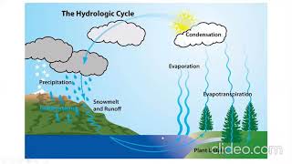
Infiltration indices, derived from empirical observations, play a pivotal role in various engineering applications relating to hydrology. Understanding how to apply these indices can greatly improve urban infrastructure and water resource management. This section outlines four main applications:
- Urban Drainage Design: Infiltration indices assist engineers in designing effective stormwater drainage systems using methodologies like the rational method or unit hydrograph method. They allow for better forecasting of runoff and drainage capacities, leading to more resilient urban environments.
- Flood Forecasting: By estimating rainfall excess, infiltration indices enable more accurate flood modeling. This is critical for emergency preparedness and reducing the risk of flood damage.
- Catchment Modeling: Infiltration indices serve as simplified inputs for hydraulic and hydrologic models, such as HECHMS (Hydrologic Engineering Center's Hydrologic Modeling System). These models analyze potential runoff scenarios, which is essential for watershed management.
- Irrigation Planning: They also help in determining percolation losses in agricultural fields, ensuring that irrigation practices are both efficient and sustainable.
Ultimately, the application of infiltration indices streamlines the analysis of rainfall-runoff processes, enhancing planning and decision-making in engineering contexts.
Youtube Videos
![Introduction to Engineering Hydrology and its Applications [Year - 3]](https://img.youtube.com/vi/Sds3dB-hA8E/mqdefault.jpg)


Audio Book
Dive deep into the subject with an immersive audiobook experience.
Urban Drainage Design
Chapter 1 of 4
🔒 Unlock Audio Chapter
Sign up and enroll to access the full audio experience
Chapter Content
For designing stormwater drainage systems using rational method or unit hydrograph method.
Detailed Explanation
In urban areas, proper drainage systems are essential to manage stormwater effectively and prevent flooding. Engineers apply infiltration indices to predict how much rainwater will infiltrate into the ground versus how much will flow over land. This helps in designing drainage systems that can handle expected runoff during heavy rainfall. The rational method involves calculating peak discharge based on rainfall intensity and area, while the unit hydrograph method uses historical data to model runoff over time.
Examples & Analogies
Think of a city like a large sponge; when it rains, the sponge absorbs some water (infiltration), but if the rain is too heavy or fast, the sponge overflows. For engineers, the challenge is ensuring that the sponge doesn't overflow onto the streets, so they design drainage systems that channel excess water safely away.
Flood Forecasting
Chapter 2 of 4
🔒 Unlock Audio Chapter
Sign up and enroll to access the full audio experience
Chapter Content
Estimating rainfall excess for flood modeling.
Detailed Explanation
Flood forecasting is crucial for public safety and disaster management. By using infiltration indices, engineers can estimate how much rainfall will turn into surface runoff—the water that doesn't soak into the ground. This is particularly important in flood-prone areas, where knowing the potential runoff can inform early warning systems and emergency response plans.
Examples & Analogies
Imagine a big bowl under a shower. If the shower runs too long, the bowl will overflow. In flood forecasting, engineers use rainfall data to see if the shower (rain) will fill the bowl (land) past the point of safety, helping communities prepare and respond effectively.
Catchment Modeling
Chapter 3 of 4
🔒 Unlock Audio Chapter
Sign up and enroll to access the full audio experience
Chapter Content
Simplified inputs for hydrologic models like HEC-HMS.
Detailed Explanation
Catchment modeling involves simulating how water moves through a watershed. Hydrologists use simplified representations, including infiltration indices, to estimate how rainfall will behave in various conditions. Tools like HEC-HMS (Hydrologic Engineering Center's Hydrologic Modeling System) rely on these indices as inputs to predict runoff and water flow, which supports water resource management and planning.
Examples & Analogies
Think of catchment modeling like modeling traffic patterns on a busy highway. Just as traffic engineers use simplified models to predict where cars will go during rush hour, hydrologists use infiltration indices to forecast how water will travel through a landscape after it rains.
Irrigation Planning
Chapter 4 of 4
🔒 Unlock Audio Chapter
Sign up and enroll to access the full audio experience
Chapter Content
Determining percolation losses in agricultural fields.
Detailed Explanation
In agriculture, knowing how much water infiltrates the soil and how much is lost to percolation is essential for efficient irrigation management. By applying infiltration indices, farmers can optimize their irrigation practices, ensuring that crops receive enough water without wasting resources. This helps in planning when and how much to irrigate, which is vital in dry regions.
Examples & Analogies
Consider a farmer watering their garden. If they know the soil absorbs water quickly, they can water less frequently. But if the ground is hard and water runs off, they need to adjust their plans. Using infiltration indices helps farmers make these decisions to grow healthy crops while conserving water.
Key Concepts
-
Infiltration Indices: Tools used to simplify the analysis of infiltration processes.
-
Urban Drainage Design: A crucial application ensuring effective stormwater management.
-
Flood Forecasting: Predicts flooding impacts to assist in emergency management.
-
Catchment Modeling: Helps simulate runoff processes for watershed management.
-
Irrigation Planning: Aids in optimizing water resources for agriculture.
Examples & Applications
Using the φ-index to estimate runoff during a storm in a urban area.
Using the W-index in irrigation planning to account for initial water losses due to soil saturation.
Memory Aids
Interactive tools to help you remember key concepts
Rhymes
Infiltration helps water flow, through soil it goes like a show.
Stories
A farmer uses infiltration indices to ensure his crops receive the right amount of water while preventing floods, balancing his resources efficiently.
Memory Tools
Use 'F-I-C-I' to remember: Floods, Infiltration, Catchments, Irrigation.
Acronyms
Remember 'D-F-C-I' for Drainage, Flood, Catchment, Irrigation using indices.
Flash Cards
Glossary
- Infiltration Indices
Empirical tools representing average infiltration characteristics of storm events used for hydrological analysis.
- Urban Drainage Design
Engineering principles focused on developing stormwater management systems for urban environments.
- Flood Forecasting
The process of predicting the occurrence and impact of flooding based on rainfall and runoff data.
- Catchment Modeling
Creating models to simulate hydrological processes in watersheds to understand runoff behavior.
- Irrigation Planning
The process of managing water supply for agricultural fields to optimize plant growth.
Reference links
Supplementary resources to enhance your learning experience.