
Distribution of Groundwater
Enroll to start learning
You’ve not yet enrolled in this course. Please enroll for free to listen to audio lessons, classroom podcasts and take practice test.
Interactive Audio Lesson
Listen to a student-teacher conversation explaining the topic in a relatable way.
Regional Distribution in India
🔒 Unlock Audio Lesson
Sign up and enroll to listen to this audio lesson

Today we're going to discuss the distribution of groundwater, particularly focusing on India. Can anyone tell me where we might find high-yield aquifers?

I think the Indo-Gangetic plains have high-yield aquifers because of their sediment.
Exactly! The Indo-Gangetic plains contain unconfined aquifers with high yields. Can anyone explain why that is?

Because they are made up of alluvial deposits that hold water well?
Correct! The permeability of alluvial deposits allows for significant water storage. How does this compare to the peninsular region?

The peninsular region has hard rock, so they have weathered and fractured aquifers with lower yields.
Great observation! Remember, 'hard rock' leads to lower water availability. Let's summarize: Alluvial plains are high-yield areas, while the peninsular regions have less productive aquifers.
Factors Influencing Distribution
🔒 Unlock Audio Lesson
Sign up and enroll to listen to this audio lesson

Next, let’s explore what influences groundwater distribution. Who can name one factor?

I think geology is important because it affects what kind of aquifers we have.
Absolutely! The geology and structure of an area determine the nature of the aquifers present. What else might play a role?
Rainfall! Areas with more rain likely have better groundwater recharge.
Exactly! Rainfall and climate are crucial for replenishing groundwater. What about human factors?
Human activities like pumping can deplete groundwater resources, right?
Yes! Human intervention can drastically alter groundwater distribution. Great job, everyone! To recap, the main factors influencing groundwater distribution are geology, rainfall, topography, land use, and human actions.
Introduction & Overview
Read summaries of the section's main ideas at different levels of detail.
Quick Overview
Standard
Groundwater distribution varies significantly by region, with high-yield alluvial aquifers found in the Indo-Gangetic plains, while the hard rock terrain of peninsular India mostly contains weathered-fractured aquifers. Various factors including geology, rainfall, topography, and human activities influence the distribution patterns of groundwater.
Detailed
Distribution of Groundwater
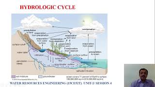
Groundwater is a critical part of the hydrological cycle and serves as a vital resource for various uses. This section provides an understanding of its distribution, particularly focusing on the regional variations found in India:
33.8.1 Regional Distribution in India
- Alluvial Plains (e.g., Indo-Gangetic): These areas feature high yield, unconfined aquifers due to their sedimentary deposits that allow for significant water storage and movement.
- Peninsular India: Characterized by hard rock terrain, primarily consisting of weathered and fractured aquifers that have lower yields compared to alluvial plains.
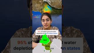
- Coastal Regions: These areas face challenges such as saltwater intrusion due to excessive groundwater pumping, impacting freshwater resources.
33.8.2 Factors Influencing Distribution
Several factors determine the distribution of groundwater:
- Geology and Structure: The type of rocks and their formations directly influence aquifer characteristics.
- Rainfall and Climate: Variations in precipitation impact water recharge rates in different regions.
- Topography: The landscape affects drainage patterns and water infiltration.
- Land Use and Vegetation: Agricultural practices and vegetation cover can enhance or hinder groundwater recharge.
- Human Intervention: Activities such as pumping and land development significantly alter groundwater distribution and availability, often leading to depletion or pollution.
Youtube Videos


Audio Book
Dive deep into the subject with an immersive audiobook experience.
Regional Distribution in India
Chapter 1 of 2
🔒 Unlock Audio Chapter
Sign up and enroll to access the full audio experience
Chapter Content
• Alluvial Plains (e.g., Indo-Gangetic): High yield, unconfined aquifers.
• Peninsular India: Hardrock terrain, mostly weathered-fractured aquifers.
• Coastal Regions: Risk of saltwater intrusion.
Detailed Explanation
This chunk describes how groundwater is distributed across different regions in India. The alluvial plains, particularly in the Indo-Gangetic area, have a high yield of groundwater and consist of unconfined aquifers, which means they are directly recharged by precipitation. In contrast, the peninsular region is characterized by hard rock formations that often lead to weathered and fractured aquifers, which can hold water but typically do not yield as much as alluvial aquifers. Additionally, coastal regions face the challenge of saltwater intrusion, where seawater can enter freshwater aquifers due to excessive pumping or a drop in freshwater levels.
Examples & Analogies
Think of the alluvial plains like a sponge that easily absorbs water when you pour it over. This represents how well they can recharge from rainwater, similar to how a sponge has large spaces to hold water. On the other hand, the peninsular region is more like a rock that has small cracks; it can hold some water, but it's harder for water to flow through, making it less efficient in supplying groundwater. Coastal regions can be visualized as a beach ball; when you press down on the ball (pumping water), the saltwater (from the ocean) can seep in, representing the intrusion of saltwater into the freshwater aquifers.
Factors Influencing Distribution
Chapter 2 of 2
🔒 Unlock Audio Chapter
Sign up and enroll to access the full audio experience
Chapter Content
• Geology and structure
• Rainfall and climate
• Topography
• Land use and vegetation
• Human intervention (e.g., pumping, land development)
Detailed Explanation
This chunk lists various factors that influence the distribution of groundwater. Geology and structure refer to the type of rocks and formations that can either facilitate or hinder groundwater flow. Rainfall and climate affect how much water is available for recharge; areas with higher rainfall will typically have more groundwater. Topography, or the physical features of the land, can influence how water moves across the landscape. Land use and vegetation play a role by impacting the amount of water that can infiltrate into the ground. Lastly, human intervention, such as groundwater pumping and land development, can significantly alter natural groundwater distribution patterns.
Examples & Analogies
Consider the distribution of groundwater like a garden. The type of soil (geology) and the rain it receives (rainfall and climate) will determine how well plants (groundwater) can grow. If there are hills and valleys (topography), it will affect how the water flows and collects. Likewise, if a gardener chooses to pave over the garden (land use), it will prevent water from soaking in, thereby impacting the growth of plants. The more care the gardener takes (less human interference), the healthier the garden will be, just as a balanced approach to land use ensures sustainable groundwater distribution.
Key Concepts
-
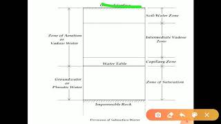
Aquifers: geological formations that store and transmit water.
-
Unconfined Aquifers: directly recharged by precipitation with a fluctuating water table.
-
Confined Aquifers: under pressure between impermeable layers, can rise above the aquifer when tapped.
-
Saltwater Intrusion: the movement of seawater into freshwater aquifers, often due to over-extraction.
Examples & Applications
The Indo-Gangetic plains have numerous unconfined aquifers that yield large quantities of groundwater for irrigation.
Coastal areas may suffer from saltwater intrusion due to excessive water extraction exacerbated by low aquifer recharge.
Memory Aids
Interactive tools to help you remember key concepts
Rhymes
In plains where the soil is deep, unconfined aquifers hold water to keep.
Stories
Imagine a farmer in the Indo-Gangetic plains who sees his crops thriving because of abundant groundwater from unconfined aquifers, while his cousin in a hard rock area struggles to find enough water due to low yields from fractured aquifers.
Memory Tools
Remember 'FACTS' for factors influencing groundwater: F for geology, A for agriculture, C for climate, T for topography, S for human actions.
Acronyms
GREAT for remembering the main factors of groundwater distribution
for Geology
for Rainfall
for Environment
for Activities
for Topography.
Flash Cards
Glossary
- Aquifer
A geological formation that stores and transmits water in usable quantities.
- Confined Aquifer
An aquifer that is sandwiched between two impermeable layers, containing water under pressure.
- Unconfined Aquifer
An aquifer where the upper surface is the water table, allowing direct recharge from precipitation.
- Weathered Fractured Aquifer
Aquifers in hard rock regions that are composed of fractured rocks allowing limited water storage and movement.
- Saltwater Intrusion
The movement of seawater into freshwater aquifers due to excessive groundwater extraction.
Reference links
Supplementary resources to enhance your learning experience.