
Methods of Groundwater Exploration
Enroll to start learning
You’ve not yet enrolled in this course. Please enroll for free to listen to audio lessons, classroom podcasts and take practice test.
Interactive Audio Lesson
Listen to a student-teacher conversation explaining the topic in a relatable way.
Remote Sensing and GIS
🔒 Unlock Audio Lesson
Sign up and enroll to listen to this audio lesson

Today, we're going to explore the ways we can discover groundwater sources. One powerful method is remote sensing and Geographic Information Systems or GIS. Can anyone tell me how these technologies help us?

They help analyze the Earth's surface to find where water might be!
Exactly! They allow us to observe features that indicate groundwater presence, like vegetation changes. Remember the acronym 'SAG': Soil, Atmosphere, and Groundwater interactions, which help us visualize these relationships.

What kind of data can we get from GIS?
Great question! We can analyze land use patterns, rainfall data, and surface water sources. These insights guide groundwater recharge strategies. Let's move on to geophysical methods.
Geophysical Methods
🔒 Unlock Audio Lesson
Sign up and enroll to listen to this audio lesson

Geophysical methods allow us to investigate the subsurface without direct drilling. Can anyone name a few geophysical techniques?

One technique is electrical resistivity!
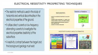
Correct! Electrical resistivity measures how much resistance subsurface materials have to electrical currents, indicating if they are saturated with water. Remember to think of 'R-E-S'—Resistivity Equals Saturation!

What about seismic refraction?
Yes! Seismic refraction uses waves to illuminate subsurface structures. The speed of these waves changes based on material density and can reveal aquifer locations.
Test Drilling and Borehole Logging
🔒 Unlock Audio Lesson
Sign up and enroll to listen to this audio lesson
Let's talk about test drilling and borehole logging. Why do you think these methods are important?
They give us direct access to underground materials, right?
Exactly! Drilling allows us to collect soil and rock samples and learn about the aquifer's composition. Think of 'DRS' – Drilling Reveals Subsurface.
What do we log during this process?
Great follow-up! We log depth, lithology, water levels, and more, helping to create a detailed profile of the aquifer.
Pumping Tests
🔒 Unlock Audio Lesson
Sign up and enroll to listen to this audio lesson
Lastly, let’s discuss pumping tests. Who can explain what we achieve with these tests?
They help us find out how much water an aquifer can supply, right?
That's right! Pumping tests measure the rate at which water levels decline when water is pumped out, indicating transmissivity and storativity of the aquifer. Remember 'P-E-T' – Pumping Essential for Testing!
Why is it important to know those properties?
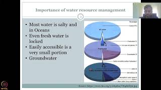
Knowing these properties helps us understand how sustainable a water supply from that aquifer is, which is crucial for water resource management.
Introduction & Overview
Read summaries of the section's main ideas at different levels of detail.
Quick Overview
Standard
Groundwater exploration employs a variety of methods essential for identifying and assessing aquifer properties. Techniques such as remote sensing and GIS, geophysical methods (including electrical resistivity and seismic refraction), test drilling, and pumping tests are critical for determining the quality, quantity, and movement of groundwater resources.
Detailed
Methods of Groundwater Exploration
Groundwater exploration is vital for assessing aquifer properties and managing water resources effectively. This section outlines several key methods:
- Remote Sensing and GIS: These technologies provide critical data for mapping aquifer locations and characteristics by analyzing surface features that influence groundwater.
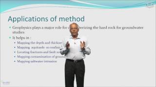
- Geophysical Methods: Various geophysical techniques are employed to investigate subsurface conditions:
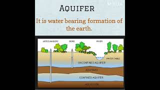
- Electrical Resistivity: Measures the resistance of the subsurface materials to electric current, helping to identify water-saturated zones.
- Seismic Refraction: Utilizes seismic waves to analyze subsurface structures and identify aquifers based on their wave characteristics.
- Gravity and Magnetic Methods: Used to detect variations in subsurface density and magnetic properties, respectively, which can indicate the presence of groundwater.
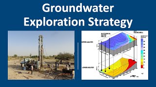
- Test Drilling and Borehole Logging: Involves drilling to sample subsurface materials directly. Borehole logging provides detailed information about the lithology, water levels, and other key parameters.
- Pumping Tests: Essential for determining aquifer properties like transmissivity and storativity. By pumping water from a well, data can be collected on how quickly water levels drop and recover, offering insights into aquifer behavior.
Through these methods, hydrogeologists gather critical information necessary for sustainable groundwater management.
Youtube Videos
Audio Book
Dive deep into the subject with an immersive audiobook experience.
Remote Sensing and GIS
Chapter 1 of 4
🔒 Unlock Audio Chapter
Sign up and enroll to access the full audio experience
Chapter Content
• Remote Sensing and GIS
Detailed Explanation
Remote sensing involves the use of satellite or aerial imagery to gather information about the Earth's surface without being in direct contact with it. Geographic Information Systems (GIS) are used to analyze and visualize this data. Together, they allow hydrologists to identify features and patterns related to groundwater resources, such as land cover, vegetation, and surface water bodies, which can indicate where aquifers might be located.
Examples & Analogies
Imagine a bird flying overhead, taking photos of the landscape below. By analyzing these images, the bird can help identify areas that are more likely to collect rainwater and recharge aquifers. Similarly, scientists use satellites to observe large areas and gather data that helps in understanding groundwater resources.
Geophysical Methods
Chapter 2 of 4
🔒 Unlock Audio Chapter
Sign up and enroll to access the full audio experience
Chapter Content
• Geophysical Methods:
– Electrical resistivity
– Seismic refraction
– Gravity and magnetic methods
Detailed Explanation
Geophysical methods involve measuring physical properties of the Earth's subsurface to explore groundwater. Electrical resistivity measures how easily electricity passes through ground materials; this helps identify water-saturated zones. Seismic refraction uses sound waves to detect changes in subsurface materials, revealing structural information about aquifers. Gravity and magnetic methods measure variations in gravity and magnetic fields to infer the presence and characteristics of groundwater-bearing rocks.
Examples & Analogies
Think of geophysical methods as using different tools to 'listen' to the Earth, similar to a doctor using a stethoscope to listen to a patient's heart. Just like the stethoscope helps the doctor understand the health of the heart, geophysical methods help scientists understand where groundwater might be found and how it moves.
Test Drilling and Borehole Logging
Chapter 3 of 4
🔒 Unlock Audio Chapter
Sign up and enroll to access the full audio experience
Chapter Content
• Test Drilling and Borehole Logging
Detailed Explanation
Test drilling involves boring into the ground to collect soil and rock samples. This helps determine the depth and quality of groundwater resources. Borehole logging is the process of recording the geological characteristics of the borehole as it is drilled. This information is critical for understanding the location and capacity of aquifers. It can include data like rock type, moisture content, and the presence of fractures that can influence water movement.
Examples & Analogies
Imagine a treasure hunter digging a hole to find buried treasure. As they dig deeper, they can see what types of materials they are encountering, which helps them understand where to go next. Similarly, test drilling allows scientists to discover valuable groundwater sources hidden beneath the surface.
Pumping Tests
Chapter 4 of 4
🔒 Unlock Audio Chapter
Sign up and enroll to access the full audio experience
Chapter Content
• Pumping Tests: To determine aquifer properties (transmissivity, storativity)
Detailed Explanation
Pumping tests involve extracting water from a well at a known rate and observing how the water level in the well changes over time. This data helps in calculating aquifer properties such as transmissivity, the ability of the aquifer to transmit water, and storativity, the amount of water that aquifer can store. Understanding these properties is crucial for managing groundwater resources sustainably.
Examples & Analogies
Think of a sponge soaking up water. If you squeeze the sponge, it releases water. By measuring how much water the sponge can absorb and how quickly it releases it, we understand its capacity. Similarly, pumping tests provide insights into how much water aquifers can hold and deliver, helping in effective groundwater management.
Key Concepts
-
Remote Sensing: A method to collect data about the Earth's surface to identify groundwater locations.
-
Geophysical Methods: Techniques used to study subsurface properties, including electrical resistivity and seismic refraction.
-
Test Drilling: Drilling to collect soil and groundwater samples directly from the ground.
-
Pumping Tests: Assessments that determine the hydraulic properties and sustainability of aquifers.
Examples & Applications
Remote sensing can identify wetlands and vegetation patterns that hint at groundwater presence.
Pumping tests conducted in a local area revealed that the aquifer had a high storativity, supporting sustainable agricultural practices.
Memory Aids
Interactive tools to help you remember key concepts
Rhymes
When searching for groundwater, look for the ground's surface, / Remote sensing shows the signs, that’s the best purpose.
Stories
Imagine a detective using tools like electrical resistivity to reveal where groundwater hides, just as detectives find clues leading to a mystery's truth.
Memory Tools
To remember the methods: 'R-G-T-P'; Think of 'Remote, Geophysical, Test drill, and Pump'.
Acronyms
Use 'D-R-S' to remember 'Drilling Reveals Subsurface'.
Flash Cards
Glossary
- Remote Sensing
The acquisition of information about an object or phenomenon from a distance, usually via satellite or aerial imagery.
- Geographic Information System (GIS)
A framework for gathering, managing, and analyzing geographical data.
- Electrical Resistivity
A geophysical method that measures the resistance of subsurface materials to electric current, indicating fluid saturation.
- Seismic Refraction
A geophysical technique that uses seismic waves to analyze subsurface geological structures.
- Borehole Logging
The process of recording physical, chemical, or geological characteristics of rock or soil from a drilled hole.
- Transmissivity
The capacity of an aquifer to transmit water through its material.
- Storativity
The amount of groundwater that an aquifer can store per unit change in hydraulic head.
Reference links
Supplementary resources to enhance your learning experience.