
Location, Extent, and Physical Features
Enroll to start learning
You’ve not yet enrolled in this course. Please enroll for free to listen to audio lessons, classroom podcasts and take practice test.
Interactive Audio Lesson
Listen to a student-teacher conversation explaining the topic in a relatable way.
Location of India
🔒 Unlock Audio Lesson
Sign up and enroll to listen to this audio lesson

Today, we are going to talk about the location of India. Can anyone tell me where India is located?

Isn't it located in the Northern and Eastern Hemispheres?
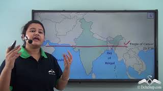
That's right! India is located in both the Northern and Eastern Hemispheres. It spans from latitudes 8°4′ N to 37°6′ N and longitudes 68°7′ E to 97°25′ E. We also have the Tropic of Cancer passing through it!

What does the Tropic of Cancer do?
The Tropic of Cancer divides India into tropical and subtropical zones, playing a key role in climate variations across the country.

What is the significance of the Standard Meridian?
Great question! The Standard Meridian of India, located at 82½° E, is vital for determining the Indian Standard Time. Think of it as the country's time reference point.

Can we remember that with a mnemonic?
Sure! You can remember the meridian with the acronym 'SIM' for 'Standard India Meridian'.
So to summarize, India is positioned in both hemispheres, is divided by the Tropic of Cancer, and operates on the Standard Meridian for time. Let's move on to the extent and size!
Extent and Size of India
🔒 Unlock Audio Lesson
Sign up and enroll to listen to this audio lesson

Now, let's discuss India's extent and size. Does anyone know how large India is?
Is it the 7th largest country in the world?
Correct! India is the seventh largest country, covering approximately 3.28 million square kilometers. It has a north-south extent of about 3,214 km and an east-west extent of 2,933 km.
What about its borders and coasts?
India has a land frontier of about 15,200 km and a coastline of 7,516.6 km, which includes its islands. This vast coast is crucial for trade and fishing.
That's interesting! How does the size affect population?
India's extensive area accommodates a high density of population, especially in fertile regions. To help remember the area facts, use '7 for Seventh Country, 3.28 Million for size, and 15,200 km for land borders.'
In conclusion, India's size and extent play a pivotal role in its geographical, cultural, and economic characteristics.
India’s Neighbours
🔒 Unlock Audio Lesson
Sign up and enroll to listen to this audio lesson
Next, let's talk about India's neighbors. Can anyone name some countries that border India?
Pakistan and Afghanistan are to the northwest!
That's correct! India shares its borders with Pakistan and Afghanistan to the northwest. What about the north and northeast?
China, Nepal, and Bhutan, right?
Yes! These three countries share borders in the north and northeast. To the east, we have Bangladesh and Myanmar. Great job!
What about maritime neighbors?
Good point! Sri Lanka and the Maldives are India’s maritime neighbors. You can remember the borders with the acronym 'PPBB' for 'Pakistan, Afghanistan, Bhutan, Bangladesh' and 'C' for China.
In summary, India shares borders with seven countries and has two maritime neighbors, which is important for geopolitics and trade.
Significance of India’s Location and Physical Features
🔒 Unlock Audio Lesson
Sign up and enroll to listen to this audio lesson
Now let's explore the significance of India's location and its physical features. Why do you think India's central position in the Indian Ocean matters?
It might be important for trade and cultural exchange, right?
Exactly! India's location has historically made it a hub for cultural and economic interactions between East and West Asia. Its long coastline facilitates maritime links and trade.
How do physical features affect agriculture?
Great question! India's physical features like mountains, plains, and plateaus create varied climates and fertile regions for agriculture. For instance, the northern plains are agriculturally rich due to alluvial deposits.
Can we remember the importance of physical features with a rhyme?
Sure! 'Mountains soar, plains nourish, plateaus store, coastal shores trade evermore!' This captures the essence of each feature's importance.
To sum up, India's location is significant for trade and culture, and its diverse physical features support agriculture, trade, and biodiversity.
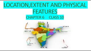
Major Physical Divisions of India
🔒 Unlock Audio Lesson
Sign up and enroll to listen to this audio lesson
Finally, let's examine the major physical divisions of India. Who can list them?
Northern Mountains, Northern Plains, Peninsular Plateau, Indian Desert, Coastal Plains, and Islands.
Perfect! Each division has unique characteristics and importance. For instance, the Northern Mountains include the Himalayas, which impact climate and tourism.
What are the Northern Plains known for?
The Northern Plains are known for their agricultural richness, formed by the alluvium of major rivers. You can remember their importance with 'Fertilizer and Farmers in the Forefront.'
What about the importance of coastal areas?
Coastal areas are crucial for fishing and trade. Their narrow expanse houses vital deltas like the Mahanadi and Godavari.
In summary, India has six key physical divisions, each playing a significant role in its geography, economy, and culture.
Introduction & Overview
Read summaries of the section's main ideas at different levels of detail.
Quick Overview
Standard
India's geographic position and its extensive physical features influence its climate, culture, and economic significance. This section details its latitudinal and longitudinal extent, neighboring countries, and major physical divisions, including mountains, plains, plateaus, deserts, and coastal regions.
Detailed
Location, Extent, and Physical Features
Location of India
India is situated in the Northern and Eastern Hemispheres, extending from latitudinal coordinates 8°4′ N to 37°6′ N and longitudinal coordinates 68°7′ E to 97°25′ E. The Tropic of Cancer (23½° N) traverses almost the center of India, demarcating tropical from subtropical areas. The country's Standard Meridian (82½° E), located near Mirzapur, is essential for determining Indian Standard Time (IST).
Extent and Size of India
India holds the title of the seventh-largest country globally, covering 3.28 million square kilometers. Its dimensions span approximately 3,214 km in a north-south direction and 2,933 km in an east-west direction, possessing a land frontier of about 15,200 km and a coastline of 7,516.6 km, which includes the coastal territories of its islands.
India’s Neighbours
India shares its borders with seven countries: Pakistan and Afghanistan to the northwest; China, Nepal, and Bhutan to the north and northeast; and Bangladesh and Myanmar to the east. Additionally, Sri Lanka and the Maldives are its maritime neighbors.
Significance of India’s Location
India's strategic position in the Indian Ocean enhances its sea trade and has historically established it as a crossroads for cultural and economic interactions between East and West Asia. The extensive coastline has facilitated maritime links and international traders for centuries.
Major Physical Divisions of India
India’s landscape can be categorized into six main physiographic divisions:
1. The Northern Mountains: Comprises the Himalayas, including the Himadri (highest peaks), Himachal (hill stations), and Shiwaliks (foothill ranges).
2. The Northern Plains: Fertile alluvial plains formed by the Indus, Ganga, and Brahmaputra river systems.
3. The Peninsular Plateau: The oldest landmass formed by tectonic activity with rich mineral deposits and significant river systems like the Narmada and Godavari.
4. The Indian Desert: Located in western Rajasthan, known as the Thar Desert, characterized by sandy soil and sparse rainfall.
5. The Coastal Plains: Coastal strips alongside the Arabian Sea and Bay of Bengal, featuring major deltas.
6. The Islands: Including the Andaman and Nicobar Islands (volcanic origin) and Lakshadweep Islands (coral origin).
Importance of India’s Physical Features
The mountains influence climate patterns and biodiversity. The plains support intensive agriculture and are densely populated. Plateaus contribute to mineral wealth and distinct farming practices. Coastal regions offer avenues for trade and tourism, whereas islands enhance biodiversity and security concerns.
Youtube Videos


Audio Book
Dive deep into the subject with an immersive audiobook experience.
Location of India
Chapter 1 of 6
🔒 Unlock Audio Chapter
Sign up and enroll to access the full audio experience
Chapter Content
● India is located in the Northern Hemisphere and Eastern Hemisphere.
● Latitudinal extent: 8°4′ N to 37°6′ N
● Longitudinal extent: 68°7′ E to 97°25′ E
● Tropic of Cancer (23½° N) passes almost through the middle of India, dividing it into tropical and subtropical zones.
● The Standard Meridian of India (82½° E) passes near Mirzapur (Uttar Pradesh) and is used as the reference for Indian Standard Time (IST).
Detailed Explanation
India is uniquely positioned in the Northern and Eastern Hemispheres, which means it is situated north of the equator and east of the prime meridian. The latitudinal extent (8°4′ N to 37°6′ N) refers to how far north India stretches from the equator. The longitudinal extent (68°7′ E to 97°25′ E) indicates the east-west span of the country. The Tropic of Cancer runs through India, creating a divide between its tropical and subtropical regions. This factor significantly influences India's climate, leading to the diversity of weather patterns across the country. Additionally, the Standard Meridian of India, which is set at 82½° E, is crucial for determining Indian Standard Time, which helps synchronize time across the nation.
Examples & Analogies
Think of India as a large clock that uses the Tropic of Cancer as the dividing line between 'morning' and 'afternoon' parts of the country, changing how the sun rises and sets in different regions. The place where the clock's hand is set (Standard Meridian) ensures that all parts of India run on the same time schedule, just like we use time zones to schedule events around the world.
Extent and Size of India
Chapter 2 of 6
🔒 Unlock Audio Chapter
Sign up and enroll to access the full audio experience
Chapter Content
● India is the 7th largest country in the world in terms of area.
● Total area: 3.28 million sq. km
● North-South extent: ~3,214 km
● East-West extent: ~2,933 km
● It has a land frontier of about 15,200 km and a coastline of 7,516.6 km (including islands).
Detailed Explanation
India covers a massive area of 3.28 million square kilometers, ranking as the seventh-largest country globally. The north-south extent of India is around 3,214 kilometers, demonstrating its long vertical stretch. In comparison, the east-west extent is approximately 2,933 kilometers. This vast area is bordered by other countries for about 15,200 kilometers and has a coastline, which is the length of the land along the ocean, of about 7,516.6 kilometers, making it significant for trade and tourism.
Examples & Analogies
Imagine India as a giant rectangular park. If you measure from the north end to the south end, it's like walking a long, scenic bet between different landscapes. Then, if you measure from one side to the other, it could take an afternoon! This park is not just about size, though—like any park, the borders help define where it meets the rest of the world, and the coast is like a beautiful line of beachfront property that everyone wants to enjoy.
India’s Neighbours
Chapter 3 of 6
🔒 Unlock Audio Chapter
Sign up and enroll to access the full audio experience
Chapter Content
● India shares borders with 7 countries:
○ Pakistan and Afghanistan (northwest)
○ China, Nepal, and Bhutan (north and northeast)
○ Bangladesh and Myanmar (east)
● Sri Lanka and Maldives are India's maritime neighbours.
Detailed Explanation
India is connected to seven neighboring countries. To the northwest, it shares borders with Pakistan and Afghanistan. To the north and northeast, the borders extend to China, Nepal, and Bhutan, while Bangladesh and Myanmar are on the eastern border. Additionally, India has maritime neighbors—countries across the sea—specifically Sri Lanka and the Maldives. These neighboring countries influence India's cultural exchange, trade, and geopolitical strategies.
Examples & Analogies
Think of India like a house in a neighborhood where it's surrounded by different friends (countries). Each friend has their style, and together they share activities whether it's cultural festivals or sports. Just like having close neighbors can enhance your experiences, these countries add to India's rich tapestry of culture and trade.
Significance of India’s Location
Chapter 4 of 6
🔒 Unlock Audio Chapter
Sign up and enroll to access the full audio experience
Chapter Content
● Central position in the Indian Ocean gives it a strategic advantage in sea trade.
● Located between East and West Asia, it has historically been a hub for cultural and economic exchanges.
● India’s long coastline has facilitated international trade and maritime links.
Detailed Explanation
India's geographical position in the Indian Ocean is crucial for international trade, acting as a significant maritime link between the East and West. This central location has historically made it a crossroads for cultural and economic exchanges, enabling the sharing of ideas and goods over centuries. The lengthy coastline enhances trade opportunities and maritime connections with numerous countries.
Examples & Analogies
Imagine India as a popular marketplace where vendors from different towns come together to trade goods. Its central spot makes it easy for merchants from far and wide to meet, trade, and share stories. Just like a bustling market encourages exchanges and collaboration, India's strategic position allows for a continuous flow of culture and commerce.
Major Physical Divisions of India
Chapter 5 of 6
🔒 Unlock Audio Chapter
Sign up and enroll to access the full audio experience
Chapter Content
India is divided into six major physiographic divisions:
3.5.1 The Northern Mountains
● Comprise the Himalayan ranges.
● Three parallel ranges:
○ Himadri (Greater Himalayas) – highest peaks like Mt. Everest, Kanchenjunga.
○ Himachal (Lesser Himalayas) – hill stations like Shimla, Mussoorie.
○ Shiwaliks (Outer Himalayas) – foothill ranges with forested valleys.
● Importance:
○ Climatic barrier
○ Source of rivers
○ Tourism, pilgrimage, and biodiversity
3.5.2 The Northern Plains
● Formed by deposition of alluvium by the Indus, Ganga, and Brahmaputra river systems.
● Flat and fertile – agriculturally rich.
● Divided into:
○ Punjab Plains (Indus basin)
○ Ganga Plains
○ Brahmaputra Valley
● High population density and extensive agriculture.
3.5.3 The Peninsular Plateau
● The oldest landmass – formed by volcanic and tectonic activity.
● Comprises:
○ Deccan Plateau (South of Narmada)
○ Central Highlands (North of Narmada)
○ Chotanagpur Plateau
● Rich in minerals and black soil.
● Rivers: Narmada, Tapi, Godavari, Krishna
3.5.4 The Indian Desert
● Lies to the northwest, in Rajasthan.
● Known as the Thar Desert.
● Features:
○ Sandy soil, dunes, scarce rainfall.
○ Rivers are mostly seasonal, e.g., Luni
3.5.5 The Coastal Plains
● Narrow coastal strips along the Arabian Sea (West) and Bay of Bengal (East).
● Western Coastal Plain: Divided into Konkan, Kannad, and Malabar Coast.
● Eastern Coastal Plain: Divided into Northern Circar and Coromandel Coast.
● Important deltas: Mahanadi, Godavari, Krishna, and Cauvery.
3.5.6 The Islands
● Andaman and Nicobar Islands (Bay of Bengal):
○ Volcanic origin
○ Strategic naval base.
● Lakshadweep Islands (Arabian Sea):
○ Coral origin (Atolls and reefs).
○ Flat and small.
Detailed Explanation
India's landscape can be divided into six major divisions. Firstly, the Northern Mountains, which are home to the Himalayas, feature three distinct ranges: the highest Himadri, the lesser Himachal, and the outer Shiwaliks, which serve critical functions such as forming climatic barriers and being a source of rivers. Secondly, the Northern Plains are notably fertile, formed by river alluvium and characterized by agricultural richness and high population density. Thirdly, the Peninsular Plateau is India's oldest landmass, rich in minerals and divided into various plateaus. Fourthly, the Indian Desert, the Thar Desert, is known for its arid conditions. Fifthly, the Coastal Plains show a clear division along both the Arabian Sea and Bay of Bengal, playing a significant role in trade. Finally, the Islands, including the Andaman and Nicobar Islands and Lakshadweep, have unique origins and strategic positions.
Examples & Analogies
Think of India's physical divisions as a big puzzle. Each piece—mountains, plains, plateaus, deserts, coastal regions, and islands—contributes to the overall picture. Just like how different types of terrains present diverse challenges and opportunities in a game of strategy, each physical division offers unique resources and habitats that affect the people and wildlife living there.
Importance of India’s Physical Features
Chapter 6 of 6
🔒 Unlock Audio Chapter
Sign up and enroll to access the full audio experience
Chapter Content
● Mountains: Influence climate, support biodiversity.
● Plains: Agriculture and dense settlements.
● Plateaus: Mineral wealth and plateau farming.
● Coastal regions: Trade, fishing, and tourism.
● Islands: Biodiversity, security, and tourism.
Detailed Explanation
The physical features of India significantly affect its environment and human activities. Mountains not only shape the climate by blocking winds but also provide diverse habitats for wildlife. The plains are vital for agriculture, supporting high populations. The plateaus possess rich mineral resources and offer spaces for specific forms of agriculture. Coastal regions are crucial for economic activities like trade and fishing while providing opportunities for tourism. Lastly, islands contribute to India's biodiversity and strategic positioning in maritime security and tourism.
Examples & Analogies
Imagine you are in a school where each class represents a part of India's physical features: the mountains are like the science class, always exploring new ideas (climate and biodiversity), the plains are the maths class (calculating and producing food), the plateaus are the history class (rich in resources), the coastal regions are like art class (creating beautiful trade opportunities), and the islands are the music class (adding unique cultural sounds to the school). All these classes work together to make the school vibrant and functional, just as India's geography supports various facets of life.
Key Concepts
-
Location: Refers to India's position in the Northern and Eastern hemispheres.
-
Extent: India's geographical size is the seventh largest in the world.
-
Physiographic Divisions: The categorization of India into six physical features that influence climate and economy.
-
Geopolitical Position: India’s interactions with neighboring countries and its strategic location.
-
Significance of Features: Each physical feature influences agriculture, trade, climate, and biodiversity.
Examples & Applications
The Himalayas are crucial for tourism and as a climatic barrier.
The Northern Plains support extensive agriculture due to fertile alluvial soil.
The Thar Desert influences the ecosystem and local adaptations for survival.
Memory Aids
Interactive tools to help you remember key concepts
Rhymes
From North to South, India spreads wide, with coastline traded, and mountains as pride.
Stories
Imagine a traveler in India who starts from the snow-capped Himalayas, walks through the lush Northern Plains, travels across the ancient Peninsular Plateau, visits the arid Thar Desert, enjoys the serene Coastal Plains, and finally relaxes on the beautiful islands of Andaman and Nicobar.
Memory Tools
To remember the six physiographic divisions of India, think of 'NPPICS': Northern Plains, Peninsular Plateau, Indian Desert, Coastal Plains, and Islands, with the 'S' reflecting the sixth feature, the Northern Mountains.
Acronyms
Use 'SPEEDY' to recall India's geographical layout
Size
Physiographic
Extent
Eastern Hemisphere
Diversity of neighbors
and yes
Youthful culture!
Flash Cards
Glossary
- Latitude
The measurement of distance north or south of the equator.
- Longitude
The measurement of distance east or west of the prime meridian.
- Tropic of Cancer
A latitude line located at 23.5° N, marking the boundary between the tropical and subtropical zones.
- Standard Meridian
A longitude used as a reference for standard time in a country.
- Physiographic Divisions
The classification of geographical areas based on physical characteristics.
- Alluvium
A type of fertile soil composed of clay, silt, sand, and gravel, deposited by running water.
- Maritime
Connection to the sea; often refers to coastal regions.
Reference links
Supplementary resources to enhance your learning experience.