
Location of India
Enroll to start learning
You’ve not yet enrolled in this course. Please enroll for free to listen to audio lessons, classroom podcasts and take practice test.
Interactive Audio Lesson
Listen to a student-teacher conversation explaining the topic in a relatable way.
Geographic Location of India
🔒 Unlock Audio Lesson
Sign up and enroll to listen to this audio lesson

Alright class, let’s start our discussion by pinpointing where India is located. Who can tell me what hemisphere India is in?

India is in the Northern Hemisphere!
Correct! And what about the Eastern Hemisphere?

Yes, it’s also in the Eastern Hemisphere.
Exactly! Now, could someone tell me its latitude and longitude?

Isn't the latitude from 8°4′ N to 37°6′ N?
Great! And what about the longitude?

It's from 68°7′ E to 97°25′ E.
Fantastic! Remember, to recall these coordinates, you could use the acronym 'LAL' for Latitude and Longitude.
That’s a good memory aid!
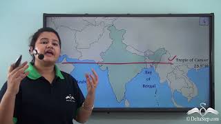
Now, who can tell me the significance of the Tropic of Cancer in India?
It divides India into tropical and subtropical areas!
Yes! And it runs very close to the middle of India!
What does that mean for the climate?
Excellent question! It leads to varied climates across India. Let's summarize: India is positioned in the Northern and Eastern Hemispheres, with latitudinal and longitudinal coordinates which help us understand its climate and geography.
Standard Meridian
🔒 Unlock Audio Lesson
Sign up and enroll to listen to this audio lesson

Next, let's delve into the concept of the Standard Meridian. Can anyone tell me what this is?
Isn't it a specific longitude that India uses for its time zone?
Yes, that's right! The Standard Meridian of India is at 82½° E. Can someone mention where it passes through?
It passes near Mirzapur in Uttar Pradesh.
Exactly! And why do you think this is important?
It helps maintain uniform time across the country, right?
Correct! It's essential for communication and transportation across vast areas. To remember this, think of the phrase 'Meridian Means Time.'
That really helps to remember it!
Good! To sum up, the Standard Meridian is crucial for defining India’s time zone and ensuring consistency throughout the country.
Climate Zones
🔒 Unlock Audio Lesson
Sign up and enroll to listen to this audio lesson
Now, let's explore the significance of the Tropic of Cancer. How does it affect climate in India?
It divides the country into tropical and subtropical regions!
Exactly! The northern part experiences subtropical climatic conditions. Can anyone explain what tropical means?
It means warm or hot throughout the year, right?
Yes! And what are some typical features of these zones in India?
The tropical zone may include forests and a lot of rain, while the subtropical zone can have more varied climates, including winter.
Great observations! Remember, when thinking of climate zones, think of the time 'Tropic Equals Temperature.' Summarizing this session, the Tropic of Cancer plays a crucial role in defining the climate of India.
Introduction & Overview
Read summaries of the section's main ideas at different levels of detail.
Quick Overview
Standard
The location of India is characterized by its geographic coordinates, with the Tropic of Cancer running through its center, dividing it into different climate zones. The Standard Meridian of India defines its time zone.
Detailed
Location of India
India is located in both the Northern and Eastern Hemispheres of the globe. Its geographical coordinates include a latitudinal extent ranging from 8°4′ N to 37°6′ N and a longitudinal extent from 68°7′ E to 97°25′ E. A significant geographical landmark, the Tropic of Cancer (23½° N), traverses through the middle of India, effectively dividing the country into tropical and subtropical regions. Furthermore, the Standard Meridian of India, positioned at 82½° E, passes near Mirzapur in Uttar Pradesh, and it is utilized as the basis for Indian Standard Time (IST). This precise positioning not only defines India's climate but also plays a crucial role in its cultural and economic contexts.
Youtube Videos


Audio Book
Dive deep into the subject with an immersive audiobook experience.
Geographical Position
Chapter 1 of 4
🔒 Unlock Audio Chapter
Sign up and enroll to access the full audio experience
Chapter Content
● India is located in the Northern Hemisphere and Eastern Hemisphere.
Detailed Explanation
India is situated in two main hemispheres: the Northern Hemisphere and the Eastern Hemisphere. This geographical position affects various climatic and cultural factors in the country. Being in the Northern Hemisphere means that India experiences seasons that are in part opposite to those in the Southern Hemisphere. For instance, when it's winter in Australia (Southern Hemisphere), it's summer in India.
Examples & Analogies
Think of it like the world being divided into two halves. In one half, when one area is baking under the sun, its counterpart in the other half might be covered in snow! Just like how it's hot and sunny in India during the summer while it can be cold and stormy in countries like Argentina located in the Southern Hemisphere.
Latitudinal and Longitudinal Extent
Chapter 2 of 4
🔒 Unlock Audio Chapter
Sign up and enroll to access the full audio experience
Chapter Content
● Latitudinal extent: 8°4′ N to 37°6′ N
● Longitudinal extent: 68°7′ E to 97°25′ E
Detailed Explanation
The latitudinal extent of India ranges from 8°4′ N in the south to 37°6′ N in the north, while its longitudinal extent stretches from 68°7′ E in the west to 97°25′ E in the east. These coordinates help to precisely locate India on the world map. The latitude affects the climate; for example, southern India is closer to the equator, making it warmer than the northern regions.
Examples & Analogies
Imagine you are playing a game of pin the tail on a map. The latitude tells you how far up or down to go (like moving in a vertical direction), and the longitude tells you how far left or right to go (like moving horizontally). Knowing these coordinates, you can find India easily on a world map just like you would find a specific location in your neighborhood when given an address.
The Tropic of Cancer
Chapter 3 of 4
🔒 Unlock Audio Chapter
Sign up and enroll to access the full audio experience
Chapter Content
● Tropic of Cancer (23½° N) passes almost through the middle of India, dividing it into tropical and subtropical zones.
Detailed Explanation
The Tropic of Cancer, located at 23½° N latitude, runs through the center of India. This imaginary line is significant because it marks the boundary between the tropical zone, where the climate is warm and wet, and the subtropical zone, which can have more extreme weather patterns. Regions south of this line tend to have a tropical climate with heavier rainfall, while regions north can be more temperate.
Examples & Analogies
Think of the Tropic of Cancer as a dividing line like the equator. If you live south of it, your summers might be really hot and full of monsoon rains, like in Kerala, whereas if you live north of it, you might experience colder winters like in Delhi. It’s similar to how in the United States, states in the south are generally warmer than those in the north.
Standard Meridian of India
Chapter 4 of 4
🔒 Unlock Audio Chapter
Sign up and enroll to access the full audio experience
Chapter Content
● The Standard Meridian of India (82½° E) passes near Mirzapur (Uttar Pradesh) and is used as the reference for Indian Standard Time (IST).
Detailed Explanation
The Standard Meridian of India is located at 82½° E longitude. This specific line helps to determine the time zone for the entire country, which is known as Indian Standard Time (IST). All clocks in India are set to the time based on this meridian. The choice of this meridian ensures that the time is uniform across a vast and diverse country like India.
Examples & Analogies
Imagine setting a common time for a big family reunion where members are coming from different places; you would need one central time that everyone follows. Likewise, India uses the Standard Meridian to avoid confusion in timekeeping, just as a family might agree to meet at 3 PM so that everyone arrives at the same time.
Key Concepts
-
Geographic Location: India is located in the Northern and Eastern Hemispheres.
-
Latitudinal Extent: Ranges from 8°4′ N to 37°6′ N.
-
Longitudinal Extent: Ranges from 68°7′ E to 97°25′ E.
-
Tropic of Cancer: Divides India into tropical and subtropical zones.
-
Standard Meridian: The Standard Meridian of India is at 82½° E and is used for IST.
Examples & Applications
The Tropic of Cancer passes through India and significantly impacts its climate.
The Standard Meridian (82½° E) influences the uniformity of time across India.
Memory Aids
Interactive tools to help you remember key concepts
Rhymes
Latitude and Longitude, measure north and east, for India's position, they're the utmost feast!
Stories
Imagine India as a big clock, with the Tropic of Cancer as the hand separating the warm areas and the cold, showing how geography shapes life.
Memory Tools
Use 'Tropical Locations Exist Beyond Standard Time' to remember: Tropic of Cancer's impact on climate, latitude and longitude, and time standard.
Acronyms
Remember 'LATS' for Latitude, Areas, Time, and Significance to recall key geographical features of India.
Flash Cards
Glossary
- Northern Hemisphere
The half of the earth that is north of the equator.
- Eastern Hemisphere
The half of the earth that is east of the Prime Meridian.
- Tropic of Cancer
A circle of latitude that runs approximately 23½° north of the equator, marking the northern limit of the tropics.
- Longitude
The angular distance of a place east or west of the Prime Meridian.
- Latitude
The angular distance of a place north or south of the equator.
- Standard Meridian
The meridian used as a reference for standard time in a specific region.
Reference links
Supplementary resources to enhance your learning experience.