
Drone Surveying for Road Development
Enroll to start learning
You’ve not yet enrolled in this course. Please enroll for free to listen to audio lessons, classroom podcasts and take practice test.
Interactive Audio Lesson
Listen to a student-teacher conversation explaining the topic in a relatable way.
Introduction to Drone Surveying
🔒 Unlock Audio Lesson
Sign up and enroll to listen to this audio lesson

Welcome everyone! Today, we'll be discussing the fascinating world of drone surveying in road development. Can anyone tell me what drones are and their general use in engineering?

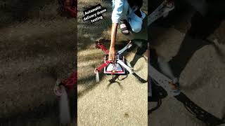
Drones are unmanned flying devices that can take pictures and gather data from above.
Exactly! They’re also known as Unmanned Aerial Vehicles or UAVs. Now, let's connect this to civil engineering. How do you think drones can help in road development?

They can probably be used for surveying land to see where the road will go?
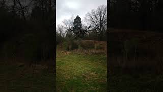
That's spot on! Drones can quickly gather high-resolution images and create topographic maps. This data helps in planning the road alignment. Let's remember it as 'Fast and Accurate Data' or FAD!

So, they make things quicker, right?
Absolutely, they also reduce manual errors. In traditional methods, human error could be a significant hurdle. Let's summarize—drones help in providing fast and accurate data, and they reduce manual errors. Great start!
Implementation by NHAI
🔒 Unlock Audio Lesson
Sign up and enroll to listen to this audio lesson

Continuing from our last session, let's talk about the National Highways Authority of India, or NHAI, and how they utilize drone technology.
How does NHAI benefit from using drones?
Great question. NHAI adopted drones for land surveying and progress monitoring. This approach minimizes manual errors significantly. Can someone think why reducing errors is crucial?
If there are fewer errors, projects can be approved faster!
Exactly! Faster approvals are essential for timely project execution. It helps in effectively managing project timelines and resources. We can use 'MERCY'—Minimize Errors, Rapid Cycle Yield for this!

So, drones help save time and costs too!
Yes! Let’s wrap up by summarizing: NHAI's use of drones not only minimizes errors but also speeds up approvals, directly impacting project efficiency.
Advantages of Drone Surveying
🔒 Unlock Audio Lesson
Sign up and enroll to listen to this audio lesson
Now that we know how NHAI benefits, let’s zoom into the broader advantages of using drones in surveying. What do you think are the primary benefits?
I think they provide a different view of the project site!
Correct! An aerial view allows for comprehensive monitoring of the entire site. This is essential for large projects like highways. Can anyone think of other advantages?
They’re probably faster in collecting data than people on the ground.
Absolutely! That speed translates into efficient project management. Remember 'PAVE'—Precision, Aerial View, Velocity, and Efficiency—these are critical terms to keep in mind!
What about safety? Do drones make surveying safer?
Yes, they enhance safety by reducing the need for personnel to work in potentially hazardous areas. In summary, drones provide precision, aerial views, speed, and increased safety—PAVE is essential.
Introduction & Overview
Read summaries of the section's main ideas at different levels of detail.
Quick Overview
Standard
In this section, we discuss how the National Highways Authority of India (NHAI) utilizes drones for land surveying and progress monitoring in road development projects. The implementation of drones significantly minimizes manual errors and speeds up the approval processes, showcasing their essential role in modern civil engineering.
Detailed
Drone Surveying for Road Development
The use of drones, or Unmanned Aerial Vehicles (UAVs), has revolutionized the field of surveying and monitoring in civil engineering, specifically in road development. The National Highways Authority of India (NHAI) has implemented drone technology not only for land surveying but also for ongoing project assessment. This integration has resulted in a substantial reduction of manual errors during survey processes and accelerates the necessary approvals for road construction projects.
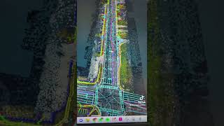
In traditional surveying methods, a lot of time was spent manually gathering data, which was not only tedious but also prone to human error. Drones provide a solution by capturing high-resolution imagery and creating accurate topographic maps and models. The topographical data generated through drone surveying helps in planning the road alignment and monitoring the progress of the construction.
Drones enhance project efficiency by delivering timely insights into site conditions and progress. This leads to faster decision-making and improved management of resources. Furthermore, the aerial perspective provided by drones allows for comprehensive monitoring of the entire site, which is invaluable in managing large projects like highway construction.
The adoption of drones in civil engineering underlines a significant shift toward automation and precision in surveying techniques, reinforcing the drive towards more innovative and reliable construction methodologies.
Youtube Videos


Audio Book
Dive deep into the subject with an immersive audiobook experience.
Overview of Drone Implementation
Chapter 1 of 3
🔒 Unlock Audio Chapter
Sign up and enroll to access the full audio experience
Chapter Content
NHAI (National Highways Authority of India) implemented drones for land surveying and progress monitoring in highway projects, reducing manual errors and expediting approvals.
Detailed Explanation
The National Highways Authority of India (NHAI) has started using drones in their highway projects. Drones help in land surveying, which is crucial for planning and executing these projects. By using drones, NHAI can obtain accurate data about the land, which reduces mistakes that can occur with traditional manual surveying methods. Additionally, using drones speeds up the approval processes because they can quickly gather the necessary information required by authorities to move forward with the projects.
Examples & Analogies
Think of using drones as like using a smartphone to take a photo instead of drawing a picture by hand. The smartphone can give you a quick, accurate representation of what's in front of you, just as drones provide clear images and data about the land needed for road development.
Reduction of Manual Errors
Chapter 2 of 3
🔒 Unlock Audio Chapter
Sign up and enroll to access the full audio experience
Chapter Content
Using drones for land surveying reduces manual errors.
Detailed Explanation
Manual surveying can be prone to errors due to several factors, such as human miscalculation, fatigue, or even environmental conditions. Drones, on the other hand, operate with advanced technology that ensures high precision in data collection. They can capture images and data from various angles and heights, allowing for more comprehensive analysis. This advantage significantly lowers the chances of mistakes, ensuring that the information used for road development is accurate.
Examples & Analogies
Imagine trying to measure your backyard with a tape measure versus using a drone to map it out. The tape measure might slip or you might misread the numbers, but a drone will give a precise layout without room for human error.
Expedited Approval Processes
Chapter 3 of 3
🔒 Unlock Audio Chapter
Sign up and enroll to access the full audio experience
Chapter Content
Drone surveying allows quicker approvals for highway projects.
Detailed Explanation
The data collected by drones can be processed and shared much quicker than traditional methods, where documentation and analysis can take days or weeks. This speed is crucial in infrastructure projects because it allows quicker decision-making and progress. Authorities can analyze the survey data in real-time, making it easier for them to give the green light for the next steps of construction, which ultimately helps in completing the projects more rapidly.
Examples & Analogies
It’s similar to using an instant messaging app versus sending a letter. A message can be delivered and read immediately, while a letter takes days to arrive. With drones, the information reaches the decision-makers almost instantly, speeding up the whole process.
Key Concepts
-
Drones significantly reduce manual errors in surveying.
-
NHAI's implementation of drone technology speeds up approval processes.
-
Aerial views provided by drones enhance project monitoring and management.
Examples & Applications
NHAI's use of drones for surveying land, which expedited highway construction.
The creation of topographic maps through drone data to inform road alignment.
Memory Aids
Interactive tools to help you remember key concepts
Rhymes
Up, up in the sky, drones fly high, helping land survey without a sigh!
Stories
Imagine a bustling construction site where workers use traditional tools to take measurements. Frustration mounts as errors delay progress. Then, a drone swoops in, capturing the land from above, creating maps and speeding up the entire project. It's a tale of transformation!
Memory Tools
Remember 'DRAWS' for Drones Reduce Approval Waits and Surveying errors.
Acronyms
FAD - Fast and Accurate Data to remember the efficiency of drones.
Flash Cards
Glossary
- Drones (UAVs)
Unmanned Aerial Vehicles used for aerial surveying and data collection.
- National Highways Authority of India (NHAI)
An organization responsible for the management of highway infrastructure in India, implementing drone technology for construction projects.
- Topographic Mapping
The process of creating detailed maps that illustrate the physical features of a land surface.
Reference links
Supplementary resources to enhance your learning experience.