
Urban and Regional Planning
Enroll to start learning
You’ve not yet enrolled in this course. Please enroll for free to listen to audio lessons, classroom podcasts and take practice test.
Interactive Audio Lesson
Listen to a student-teacher conversation explaining the topic in a relatable way.
Land Use Planning
🔒 Unlock Audio Lesson
Sign up and enroll to listen to this audio lesson

Today, we'll be discussing Land Use Planning, which focuses on how we designate different areas for specific functions, like residential, commercial, or green spaces. Does anyone know what zoning is?

Isn't zoning a way to separate different types of land uses, like making sure factories aren't built next to homes?
Exactly, Student_1! Zoning helps reduce conflicts between land uses. It's a crucial aspect of maintaining community harmony. Can anyone think of examples of zoning classifications?

I think we have residential, commercial, and industrial zones.
Great! And don’t forget about green belts. These areas help manage development and provide recreational spaces. Let's remember this with the acronym ZIG—Zoning, Infrastructure, Green belts.
Infrastructure Planning
🔒 Unlock Audio Lesson
Sign up and enroll to listen to this audio lesson

Now, let's discuss Infrastructure Planning—what do you think it encompasses?

I guess it includes roads and public transportation?
Correct! It also covers utilities and open spaces in urban design. In fact, the concept of 'smart cities' integrates these elements using technology. Has anyone heard of smart city platforms?

I think they use IoT to monitor city functions, right?
That’s right! We can remember this with the mnemonic SITS: Smart city, Infrastructure, Transportation, Services.
Urban Design
🔒 Unlock Audio Lesson
Sign up and enroll to listen to this audio lesson
Let’s move on to Urban Design. Why do you think it matters?
It makes cities more functional and friendly for people, right?
Exactly! Urban design focuses on how streets and public spaces are laid out. Can anyone give examples of well-designed urban spaces?
Parks and pedestrian areas are good examples!
Great! To help remember, think of the acronym SPACE: Streets, Parks, Access, Connectivity, Environment.
Environmental Planning
🔒 Unlock Audio Lesson
Sign up and enroll to listen to this audio lesson
Next is Environmental Planning. Why is it crucial in urban settings?
It deals with minimizing negative impacts on nature, like heat from buildings.
Absolutely! How do we manage urban heat islands, for example?
Using green roofs and parks can help cool the area.
Exactly! A helpful mnemonic for environmental strategies is GREEN: Gardens, Resilience, Energy efficiency, Ecosystems, Nature.
GIS Applications
🔒 Unlock Audio Lesson
Sign up and enroll to listen to this audio lesson
Now, let's discuss GIS Applications. What role does GIS play in urban planning?
It's used for mapping and analyzing data about the city!
Exactly! GIS helps visualize demographic and land use data. Why do you think this information is essential for planners?
It helps them make data-driven decisions for better city layouts.
Well said! Remember the acronym MAP: Mapping, Analysis, Planning.
Introduction & Overview
Read summaries of the section's main ideas at different levels of detail.
Quick Overview
Standard
This section delves into the importance of urban and regional planning, covering key aspects like land use, infrastructure, urban design, environmental considerations, and the integration of GIS applications. The role of automation and smart technologies in enhancing urban planning practices is also highlighted.
Detailed
Urban and Regional Planning is a vital component in civil engineering, focused on organizing land use to create functional, sustainable, and accessible environments. This encompasses various elements:
- Land Use Planning: This involves zoning regulations, urban classifications, and the establishment of green belts to balance development with nature.
- Infrastructure Planning: Critical elements such as transportation networks, utilities, and public spaces are outlined, especially in the context of smart cities.
- Urban Design: It addresses the layout of street networks and the accessibility of public spaces, ensuring that urban areas are designed for all residents.
- Environmental Planning: Key considerations include managing urban heat islands, incorporating green infrastructure, and formulating strategies for disaster resilience.
- GIS Applications: Geographic Information Systems play a crucial role in urban mapping, demographic analysis, and scenario simulations, greatly aiding planners in decision-making.
The integration of automation in urban planning, through smart city platforms, AI simulations, and remote sensing, demonstrates a transformative shift towards data-driven decision-making in urban and regional environments.
Youtube Videos


Audio Book
Dive deep into the subject with an immersive audiobook experience.
Definition and Scope of Urban and Regional Planning
Chapter 1 of 3
🔒 Unlock Audio Chapter
Sign up and enroll to access the full audio experience
Chapter Content
Urban and Regional Planning focuses on the development and design of land use and the built environment, including infrastructure, transportation systems, and public spaces.
Detailed Explanation
Urban and Regional Planning is a discipline that involves creating strategies for managing land and resources in urban and rural areas. This includes how land is used (such as for residential, commercial, or recreational purposes) and how cities are designed. The overarching aim is to shape environments that improve the quality of life for residents while ensuring sustainable development.
Examples & Analogies
Consider a small city planning to expand. Urban planners will assess the land available for housing, parks, and roads, making sure these areas are well-connected and provide residents with essential services like schools and transportation options. This is like a puzzle — each piece must fit together so that the entire picture is balanced and functional.
Core Concepts of Urban Planning
Chapter 2 of 3
🔒 Unlock Audio Chapter
Sign up and enroll to access the full audio experience
Chapter Content
Core Concepts:
• Land Use Planning: Zoning, urban land classification, green belts.
• Infrastructure Planning: Roads, utilities, open spaces, smart cities.
• Urban Design: Street networks, public spaces, accessibility.
• Environmental Planning: Urban heat islands, green infrastructure, disaster resilience.
• GIS Applications: Urban mapping, demographic analysis, scenario simulations.
Detailed Explanation
The core concepts of Urban Planning include:
1. Land Use Planning: This process involves designating specific areas for different uses such as residential, commercial, and recreational. Zoning laws help in managing how land is developed.
2. Infrastructure Planning: Urban planners must ensure that essential services like roads, water supply, and electricity can support the growing population. This might lead to the development of smart cities that utilize technology for better efficiency.
3. Urban Design: This focuses on the physical layout of a city, ensuring that streets are navigable, public spaces are inviting, and amenities are easily accessible.
4. Environmental Planning: Urban planners aim to mitigate issues such as heat from increased concrete surfaces (urban heat islands) and promote sustainable practices like green roofs.
5. GIS Applications: Geographic Information Systems (GIS) allow urban planners to visualize data related to demographics, land use, and environmental features, helping them simulate and analyze potential urban scenarios effectively.
Examples & Analogies
Think of a gardener planning a community garden. They need to decide where to plant flowers, vegetables, and walking paths, considering how much sunlight each area gets, how people will access it, and ensuring there's room for compost and water points. Just like this gardener, urban planners need to carefully consider how to use land effectively for everyone's benefit.
Role of Automation in Urban Planning
Chapter 3 of 3
🔒 Unlock Audio Chapter
Sign up and enroll to access the full audio experience
Chapter Content
Role of Automation:
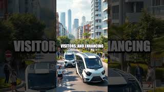
• Smart city platforms integrating IoT and GIS for real-time monitoring.
• Automated traffic and pedestrian flow simulations using AI.
• Drones and remote sensing for land-use monitoring.
• Urban planning supported by 3D city modeling and digital twins.
Detailed Explanation
Automation plays a significant role in enhancing Urban Planning through various technologies:
1. Smart City Platforms: These integrate Internet of Things (IoT) devices and Geographic Information Systems (GIS), allowing for real-time data collection and monitoring of urban environments, such as traffic conditions and pollution levels.
2. Traffic and Pedestrian Simulations: Artificial intelligence can simulate how traffic patterns change throughout the day, helping planners optimize street layouts and manage congestion effectively.
3. Drones and Remote Sensing: Drones equipped with cameras and sensors help monitor land use and track changes over time, providing invaluable data to city planners.
4. 3D Modeling and Digital Twins: By creating detailed digital representations of cities, planners can visualize scenarios and make better decisions regarding urban design and infrastructure development.
Examples & Analogies
Imagine a city as a video game. Just like game designers use powerful software to design maps and simulate player movements, urban planners are using smart technologies to understand how cities function in real-time and make improvements accordingly. It's as if they have a cheat sheet, guiding them to create more efficient, livable spaces for everyone.
Key Concepts
-
Land Use Planning: The strategic process of evaluating and assigning different land categories.
-
Zoning: A critical tool for land use regulation to prevent conflicts between incompatible land uses.
-
Infrastructure Planning: Essential for effective public service delivery and urban functionality.
-
Smart Cities: The integration of technology and data for sustainable urban management.
-
Environmental Planning: Ensures that development considers ecological impacts.
Examples & Applications
A city implementing green roofs and parks to combat urban heat islands.
The use of GIS to analyze demographic trends and plan new housing developments.
Memory Aids
Interactive tools to help you remember key concepts
Rhymes
In a city where dreams unfold, land is planned in ways to behold.
Stories
Once in a bustling city, each area had its purpose: homes, shops, parks. City planners made sure to keep harmony, creating a vibrant and effective community. That's urban planning!
Memory Tools
Remember SPACE for Urban Design: Streets, Parks, Access, Connectivity, Environment.
Acronyms
Use SITS for Smart City strategies
Smart city
Infrastructure
Transportation
Services.
Flash Cards
Glossary
- Land Use Planning
The process of evaluating and designating the uses of land within a region.
- Zoning
Regulatory framework that defines how land in specific geographic zones can be used.
- Smart City
An urban area that uses smart and sustainable technologies to manage resources and services efficiently.
- Infrastructure
The basic physical and organizational structures needed for the operation of a society or enterprise.
- Environmental Planning
Planning processes that consider environmental factors to minimize harmful impacts.
- GIS
Geographic Information Systems that analyze spatial and geographic data.
Reference links
Supplementary resources to enhance your learning experience.