
Surveying and Remote Sensing
Enroll to start learning
You’ve not yet enrolled in this course. Please enroll for free to listen to audio lessons, classroom podcasts and take practice test.
Interactive Audio Lesson
Listen to a student-teacher conversation explaining the topic in a relatable way.
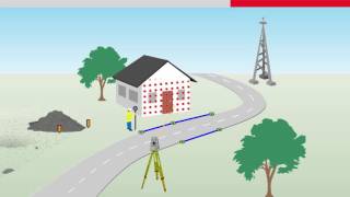
Traditional Surveying Techniques
🔒 Unlock Audio Lesson
Sign up and enroll to listen to this audio lesson

Today, we're starting with traditional surveying techniques. Can anyone tell me what methods we might use?

I think chain surveying is one technique.
That's right! Chain surveying is primarily used for measuring distances using a chain. Can anyone explain why traditional methods are still important?

Maybe because they’re simple and don’t require advanced technology?
Exactly! It's accessible in areas where technology might fail. Does anyone know other traditional methods?

There's the theodolite!
Yes, the theodolite measures angles and is crucial for triangulation. Remember the acronym 'CTT' for Chain, Theodolite, Total Station techniques. Let’s summarize: chain surveying is basic, theodolites measure angles. What about total stations?

They combine optical and electronic measuring!
Correct! Total stations are versatile. In summary, we discussed the importance of traditional techniques in surveying: Chain measuring, Theodolite for angles, and Total Stations for electronic measuring.
Modern Techniques: GPS and LiDAR
🔒 Unlock Audio Lesson
Sign up and enroll to listen to this audio lesson

Now, let's shift to modern surveying techniques like GPS and LiDAR. Who can explain GPS?
GPS uses satellites to provide precise location data!
Fantastic! It allows for real-time positioning. How about LiDAR?
LiDAR uses laser light to measure distances and create detailed maps!
Exactly! It's very precise and effective for terrain modeling. Can anyone see how these technologies benefit construction?
They can create 3D models quickly for planning?
Right! They significantly speed up the planning phase. Utilizing the acronym 'GLPD' can help remember: GPS, LiDAR, Precision, Data. Let's recap: GPS provides location, LiDAR creates maps, and both enhance construction planning speed.
Role of Automation in Surveying
🔒 Unlock Audio Lesson
Sign up and enroll to listen to this audio lesson
Lastly, let’s explore the role of automation in surveying. How has automation changed this field?
Drones can conduct surveys faster than people!
Absolutely. UAVs (unmanned aerial vehicles) can cover vast areas quickly. What else?
Real-time monitoring?
Yes! Real-time geospatial monitoring systems are essential for infrastructure planning. Remember ‘FAST’: UAVs for Fast surveys, Automation, Sensors, Technology. Can someone summarize our conversation?
We talked about the speed drones provide, real-time data processing, and the use of land surveying in modern applications.
Perfect summary! To conclude, automation in surveying via UAVs enhances speed and accuracy, leading to better infrastructure management.
Introduction & Overview
Read summaries of the section's main ideas at different levels of detail.
Quick Overview
Standard
This section discusses various surveying methods, both traditional and modern, as well as the role of remote sensing in data collection. It highlights how these techniques are intertwined with automation, contributing to advancements in infrastructure planning and management.
Detailed
Surveying and Remote Sensing
Surveying is essential for measuring and mapping the Earth's surface, encompassing various traditional and modern techniques. Traditional methods include chain surveying, compass, theodolite, and total station systems, which rely on manual measurements. In contrast, modern techniques leverage technologies such as GPS, DGPS, LiDAR, and photogrammetry to enhance accuracy and efficiency. The intersection of Geographic Information Systems (GIS) with surveying allows for the creation of thematic maps and sophisticated spatial data analysis, facilitating better decision-making in civil engineering projects.
Role of Automation
Automation plays a significant role in enhancing surveying and remote sensing methods. Autonomous UAVs (drones) are used for topographic and aerial surveys, providing rapid data collection for large areas. Furthermore, the integration of LiDAR with artificial intelligence enables efficient terrain classification and automated data processing for 3D modeling. Real-time geospatial monitoring systems can assist in infrastructure planning, promoting sustainability and accuracy in civil engineering applications.
Youtube Videos

Audio Book
Dive deep into the subject with an immersive audiobook experience.
Definition and Scope
Chapter 1 of 8
🔒 Unlock Audio Chapter
Sign up and enroll to access the full audio experience
Chapter Content
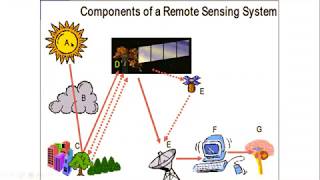
Surveying involves measurement and mapping of Earth's surface. Remote sensing enables data collection through satellites and UAVs.
Detailed Explanation
Surveying is the process of measuring land to establish positions of points and the distances and angles between them. It is crucial for creating accurate maps and works as a foundational tool for various engineering projects. Remote sensing complements this by using technology such as satellites and Unmanned Aerial Vehicles (UAVs) to gather data about the Earth's surface without direct contact. This technology allows for the collection of large amounts of data over vast areas quickly and efficiently.
Examples & Analogies
Think of surveying like measuring the length of a field with a tape measure, but instead of doing it manually, we can use advanced tools to measure large areas or entire cities quickly. Remote sensing can be compared to taking photos of the field from an airplane to see the whole layout at once rather than just measuring small sections one at a time.
Traditional Surveying Techniques
Chapter 2 of 8
🔒 Unlock Audio Chapter
Sign up and enroll to access the full audio experience
Chapter Content
• Traditional Surveying Techniques: Chain surveying, compass, theodolite, total station.
Detailed Explanation
Traditional surveying techniques involve methods that have been used for centuries. Chain surveying uses a simple measuring chain to determine distances between points. A compass helps in measuring angles relative to the magnetic north. Theodolites are more advanced tools that measure both horizontal and vertical angles. The total station combines a theodolite with an electronic distance measurement tool, allowing surveyors to capture data more accurately and efficiently.
Examples & Analogies
Imagine you're building a treehouse. You might use a tape measure (like chain surveying) to measure how far apart the trees are, a compass to figure out which direction to build it, and a level (similar to a theodolite) to ensure the floor is flat. The total station would be like having a smart tool that helps you keep everything precise as you are building.
Modern Surveying Techniques
Chapter 3 of 8
🔒 Unlock Audio Chapter
Sign up and enroll to access the full audio experience
Chapter Content
• Modern Techniques: GPS, DGPS, LiDAR, photogrammetry.
Detailed Explanation
Modern surveying techniques have revolutionized the field. GPS (Global Positioning System) utilizes satellites to provide precise location data anywhere on Earth. DGPS (Differential GPS) enhances this accuracy even further by correcting signals. LiDAR (Light Detection and Ranging) uses laser light to measure distances, creating detailed 3D maps of the terrain. Photogrammetry involves taking photographs from different angles to create accurate maps or models of an area.
Examples & Analogies
Think of GPS like using your smartphone’s map app to navigate. It gives you directions based on your current location. LiDAR is like having a super high-tech camera that not only captures images but also measures how high things are, allowing you to create 3D models of landscapes, just like how a video game developer creates terrains for an immersive experience.
Mapping and GIS
Chapter 4 of 8
🔒 Unlock Audio Chapter
Sign up and enroll to access the full audio experience
Chapter Content
• Mapping and GIS: Thematic maps, spatial data analysis.
Detailed Explanation
Mapping is the visual representation of geographic data. Geographic Information Systems (GIS) allow surveyors to analyze spatial relationships by layering different types of data on a map. Thematic maps focus on specific topics (like population density or vegetation). Spatial data analysis involves examining this data to find patterns or relationships, which can support decision-making in urban planning or environmental management.
Examples & Analogies
Imagine creating a scrapbook where each page shows different aspects of your summer vacation—like one page for photos, another for ticket stubs, and so on. GIS is like that scrapbook, allowing city planners to visualize different data types, such as where schools are located, how many people live in certain areas, and where roads are. This helps them make informed decisions about where to build new facilities or improve transportation.
Role of Automation
Chapter 5 of 8
🔒 Unlock Audio Chapter
Sign up and enroll to access the full audio experience
Chapter Content
• Role of Automation: Autonomous UAVs for topographic and aerial surveys.
Detailed Explanation
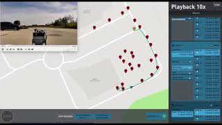
Automation in surveying mainly utilizes autonomous UAVs, or drones, which can conduct topographic and aerial surveys without human intervention. These drones can quickly cover large areas, gathering detailed data from above and providing rich imagery and measurements that can be analyzed more efficiently than traditional methods. This not only saves time but also increases accuracy and safety in data collection.
Examples & Analogies
Think of a drone as a robotic eye in the sky. Just like a bird can easily fly over a field to understand its layout, drones can gather information from above. If you're trying to understand the best place to plant a garden in a large yard, a drone can give you a quick survey from above, showing you where sunlight falls and where it's shady, helping you make the best choice without walking around with a measuring tape.
Integration of Technologies
Chapter 6 of 8
🔒 Unlock Audio Chapter
Sign up and enroll to access the full audio experience
Chapter Content
• Integration of LiDAR and AI for terrain classification.
Detailed Explanation
Integrating LiDAR with Artificial Intelligence (AI) allows for advanced analysis of terrain data. AI algorithms can classify different types of terrain, such as forests, water bodies, and urban areas, by analyzing the data collected by LiDAR. This combination improves the efficiency of data processing and enables more accurate environmental assessments and planning.
Examples & Analogies
Imagine if you had a friend who is excellent at recognizing different types of plants and animals. If you showed them photographs taken from a drone, they could quickly help you identify which are bushes, trees, or water features more accurately than if you just studied the photos alone. The combination of LiDAR's precise measurements and AI's pattern recognition is similar, allowing for better understanding and management of land.
Automated Data Processing and 3D Modeling
Chapter 7 of 8
🔒 Unlock Audio Chapter
Sign up and enroll to access the full audio experience
Chapter Content
• Automated data processing and 3D modeling.
Detailed Explanation
Automated data processing streamlines how survey data is analyzed and visualized. With advances in software, large sets of survey data can be processed quickly to create detailed 3D models of landscapes, buildings, and infrastructure. This not only improves accuracy but also allows for rapid updates to models as new data becomes available.
Examples & Analogies
Consider how you might build with LEGO blocks. If you have a computer program that instantly shows you how your project looks as you add blocks, you can quickly see where to change things without building everything physically first. Automated data processing works in a similar way, letting engineers and planners visualize designs and make adjustments quickly, saving time and resources.
Real-Time Geospatial Monitoring Systems
Chapter 8 of 8
🔒 Unlock Audio Chapter
Sign up and enroll to access the full audio experience
Chapter Content
• Real-time geospatial monitoring systems for infrastructure planning.
Detailed Explanation
Real-time geospatial monitoring systems use integrated technology to continuously collect and analyze geographic data related to infrastructure. This allows engineers to monitor conditions like land subsidence or changes in water levels in real-time, facilitating proactive maintenance and planning.
Examples & Analogies
Think of it as having a fitness tracker that monitors your steps and heart rate throughout the day. Just like the tracker gives you constant feedback on your health, real-time geospatial systems provide constant data about the conditions affecting roads, bridges, and other infrastructures, helping to keep them safe and functional.
Key Concepts
-
Traditional Surveying Techniques: Fundamental methods important for foundational surveying.
-
Modern Surveying Techniques: Advancements like GPS and LiDAR enhance surveying capabilities.
-
Role of Automation: Automation improves efficiency and accuracy in surveying practices.
Examples & Applications
An example of traditional surveying is using a theodolite to determine angles in land surveys.
Using drones equipped with LiDAR for topographic surveys can create high-resolution 3D maps.
Memory Aids
Interactive tools to help you remember key concepts
Rhymes
To survey and sense with data so bright, GPS leads the way, inching the site right.
Stories
Once upon a time, in a land of vast terrains, a group of engineers used a magical GPS and a flying drone named UAV to map out their entire kingdom with incredible accuracy! They discovered wonders and built their cities swiftly, enhancing their infrastructure with the help of LiDAR.
Memory Tools
Remember 'GLPD' for surveying techniques: GPS, LiDAR, Precision, Data.
Acronyms
The acronym ‘BEST’ helps remember the benefits of modern surveying
'Better accuracy
Easier data collection
Speed
Technology.'
Flash Cards
Glossary
- Surveying
The process of measuring and mapping the Earth's surface.
- Remote Sensing
Data collection through satellites and UAVs for analyzing the Earth's surface.
- GPS
Global Positioning System; a satellite-based navigation system that provides location information.
- LiDAR
Light Detection and Ranging; a technology that uses laser light to measure distances and create detailed maps.
- UAV
Unmanned Aerial Vehicle; commonly referred to as a drone, it is used for various surveying applications.
- GIS
Geographic Information System; software for analyzing spatial and geographic data.
Reference links
Supplementary resources to enhance your learning experience.