
Use of Unmanned Aerial Vehicles (UAVs) in Construction
Enroll to start learning
You’ve not yet enrolled in this course. Please enroll for free to listen to audio lessons, classroom podcasts and take practice test.
Interactive Audio Lesson
Listen to a student-teacher conversation explaining the topic in a relatable way.
Introduction to UAVs in Construction
🔒 Unlock Audio Lesson
Sign up and enroll to listen to this audio lesson

Today, we'll talk about Unmanned Aerial Vehicles or UAVs, commonly known as drones. They play a crucial role in modern construction practices. Can anyone tell me what you think the primary uses of drones might be on a construction site?

I think they might be used for surveying the land?

Yeah, and maybe to check on the project progress.
Great! Those are correct. UAVs are primarily used for aerial surveying, mapping, and even progress monitoring. Here's a mnemonic to remember their functions: 'SAM' - Surveying, Aerial Mapping. Let's explore these in more detail.
Detailed Functions of UAVs
🔒 Unlock Audio Lesson
Sign up and enroll to listen to this audio lesson

Let's dive into the specific functions of UAVs in construction. The first is aerial surveying and mapping. UAVs provide high-resolution images that allow for precise mapping of construction sites. Can anyone highlight the advantages of using drones for these tasks?

They can cover large areas quickly and provide more accurate data!

And it's probably safer because you don’t have people climbing to take measurements.
Exactly! Safety and efficiency are key advantages. Now moving on to progress monitoring, UAVs capture real-time footage for timely project tracking. This helps in keeping the stakeholders informed. Who can give an example of how this is useful?
It makes it easier to spot delays and adjust schedules accordingly.
Thermal Imaging and Data Integration
🔒 Unlock Audio Lesson
Sign up and enroll to listen to this audio lesson
We’ve covered the primary roles of UAVs. Another vital feature is thermal imaging. Who can tell me how thermal imaging helps in construction?
It can find heat leaks in buildings, which helps in energy efficiency!
Exactly! Identifying heat leaks can save costs and improve insulation. UAVs also integrate with GIS and BIM. Why do you think this integration is important?
It allows for comprehensive analysis and better planning throughout the project!
Correct! This integration leads to more informed decision-making. Let’s recap today’s session; we discussed how UAVs perform aerial surveying, monitor progress, and conduct thermal imaging. Great work, everyone!
Introduction & Overview
Read summaries of the section's main ideas at different levels of detail.
Quick Overview
Standard
This section details how Unmanned Aerial Vehicles (UAVs) enhance construction efficiency by providing high-resolution aerial surveys, enabling progress monitoring, and utilizing thermal imaging to identify heat leaks. Their integration into construction processes improves safety and data-driven decision-making.
Detailed
Use of Unmanned Aerial Vehicles (UAVs) in Construction
Unmanned Aerial Vehicles, commonly known as drones, have revolutionized construction management by offering a bird’s-eye view of project sites. UAVs significantly enhance site management capabilities through three core functions: aerial surveying & mapping, progress monitoring, and thermal imaging. By utilizing high-resolution orthomosaic images and elevation models, construction firms can achieve precise topographical assessments and monitor project advancements efficiently.
Key Functions:
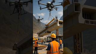
- Aerial Surveying & Mapping: UAVs capture detailed and accurate aerial surveys that facilitate the creation of 3D models and GIS integration, allowing for enhanced planning and design.
- Progress Monitoring: Drones enable time-lapse photography, making it easier to track construction progress over time, ensuring that projects meet their schedules.
- Thermal Imaging: This technology allows for identifying heat leaks in roofing systems and facade materials, thereby improving energy efficiency and safety.
Advantages of UAV Integration:
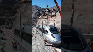
- Enhanced Safety: Drones reduce the need for workers to access hazardous areas, significantly lowering accident risks on construction sites.
- High-Frequency Data Capture: The ability to gather data rapidly allows construction managers to make swift, informed decisions, improving project efficiency.
- GIS and BIM Compatibility: UAV data seamlessly integrates with Geographic Information Systems (GIS) and Building Information Modeling (BIM) platforms, supporting comprehensive geo-referenced analysis.
In summary, the deployment of UAVs in construction not only streamlines operations but also elevates safety standards, ultimately contributing to overall project success.
Youtube Videos


Audio Book
Dive deep into the subject with an immersive audiobook experience.
Overview of UAVs in Construction
Chapter 1 of 3
🔒 Unlock Audio Chapter
Sign up and enroll to access the full audio experience
Chapter Content
Drones have revolutionized construction site management, offering bird’s-eye perspectives and real-time analytics.
Detailed Explanation
Drones, also known as unmanned aerial vehicles (UAVs), have changed how we manage construction sites. By providing aerial views, they allow for better monitoring and understanding of the construction site. This ability to capture site data from above enhances planning and decision-making.
Examples & Analogies
Imagine trying to monitor a large theme park construction from the ground—it's nearly impossible to see everything at once. However, using a drone is like having a bird flying above, giving you a full view of how everything fits together and making it easier to spot issues that need attention.
Core Functions of Drones
Chapter 2 of 3
🔒 Unlock Audio Chapter
Sign up and enroll to access the full audio experience
Chapter Content
- Aerial Surveying & Mapping: High-resolution orthomosaic and elevation models.
- Progress Monitoring: Time-lapse comparisons for project tracking.
- Thermal Imaging: Detecting heat leaks in roofing and facade materials.
Detailed Explanation
Drones perform several vital functions on construction sites:1. Aerial Surveying & Mapping: They can create detailed maps with high-resolution images that help survey land efficiently.2. Progress Monitoring: Drones can take time-lapse photos or videos, enabling teams to track progress over time and compare phases of construction.3. Thermal Imaging: Some drones are equipped with thermal cameras to help detect issues like heat leaks in buildings, which may signal insulation problems.
Examples & Analogies
Think of UAVs like a camera crew covering a sports event from the sky. They can get wide-angle shots (aerial surveys) to show the game's flow, capture milestones (progress monitoring), and zoom in on players' gear for any malfunctions (thermal imaging). This multifaceted approach keeps everything on track.
Advantages of UAVs in Construction
Chapter 3 of 3
🔒 Unlock Audio Chapter
Sign up and enroll to access the full audio experience
Chapter Content
- Enhanced safety—no need for workers to access hazardous zones.
- High-frequency data capture improves decision-making speed.
- Integration with GIS and BIM platforms for geo-referenced analysis.
Detailed Explanation
Using UAVs brings numerous advantages to construction projects:1. Enhanced Safety: Drones can access dangerous or hard-to-reach areas, reducing the risk of accidents for workers who would otherwise need to go in.2. Improved Decision-Making: Drones can capture large amounts of data quickly, allowing project managers to make informed choices faster.3. Data Integration: UAVs can work with other technologies, such as Geographic Information Systems (GIS) and Building Information Modeling (BIM), providing precise data that helps in planning and monitoring construction work.
Examples & Analogies
Imagine navigating a flooded area in an emergency. Sending drones to survey the scene provides quick assessments of damage without putting rescue workers at risk. Similarly, in construction, UAVs swiftly analyze challenges before they escalate, ensuring safety and efficiency.
Key Concepts
-
UAVs enhance construction through aerial surveying.
-
They improve safety and decision-making during construction.
-
Thermal imaging is crucial for energy efficiency.
Examples & Applications
Using UAVs for mapping the terrain before construction to plan for the building location accurately.
Employing drones to track the progress of a multi-storey building project through time-lapse video.
Memory Aids
Interactive tools to help you remember key concepts
Rhymes
Drones fly high, they survey the land, making construction work go hand in hand.
Stories
Once upon a time, a drone named Dronie helped builders see their site from the sky, ensuring no detail went awry.
Memory Tools
Remember 'SAM' - Surveying, Aerial Mapping for the key functions of UAVs.
Acronyms
Think 'D.A.T.A.' - Drones Aerially Track and Assess for understanding UAV functions.
Flash Cards
Glossary
- Unmanned Aerial Vehicle (UAV)
An aircraft that is operated without a human pilot onboard, commonly used for aerial surveys and data collection.
- Aerial Surveying
The process of collecting geographic information from an airborne platform, such as a drone, for mapping and analysis.
- Thermal Imaging
A technology that captures images using infrared radiation to reveal differences in temperature, useful for detecting heat leaks.
Reference links
Supplementary resources to enhance your learning experience.