
Autonomous Surveying: Spot by Boston Dynamics + Trimble (Worldwide)
Enroll to start learning
You’ve not yet enrolled in this course. Please enroll for free to listen to audio lessons, classroom podcasts and take practice test.
Interactive Audio Lesson
Listen to a student-teacher conversation explaining the topic in a relatable way.
Introduction to Spot
🔒 Unlock Audio Lesson
Sign up and enroll to listen to this audio lesson

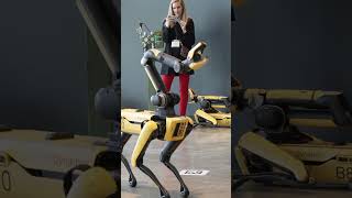
Today, we're discussing Spot, the quadruped robot from Boston Dynamics. What can you tell me about the significance of robots in construction?

Robots can help with repetitive tasks and improve accuracy.
Exactly! Spot aids in surveying and inspection by using advanced laser scanners and GPS systems. Why do you think this is beneficial for construction sites?

It can provide precise measurements and reduce errors.
Great point! By reducing errors, Spot also reduces the need for rework, saving time and costs.

What about its daily usage? How does it fit into the workflow?
Spot is utilized for daily progress monitoring, ensuring the project stays on track. Remember, accurate data helps improve communication among stakeholders!
Human-Robot Integration
🔒 Unlock Audio Lesson
Sign up and enroll to listen to this audio lesson

Let's talk about how surveyors work with Spot. What roles do surveyors play in this collaboration?

They design the paths Spot takes and decide what data needs to be collected.
Correct! This is a perfect example of human-robot integration. Why do you think human involvement is crucial?
Humans can make decisions based on the data Spot collects.
Absolutely! Humans provide the contextual understanding that robots lack. Now, let’s summarize: Spot collects valuable data, but humans decide how to utilize that data effectively.
Case Studies of Spot in Action
🔒 Unlock Audio Lesson
Sign up and enroll to listen to this audio lesson
Can anyone share where Spot has been used successfully?
I know Spot has been used in Singapore and Japan for monitoring progress.
Correct! These large-scale projects benefit greatly from Spot's ability to navigate challenging terrains. What type of results do you think this leads to?
More accurate reporting and faster project completions.
Exactly! Accurate data leads to better project communication and fewer mistakes. Remember: efficiency is key in construction!
Introduction & Overview
Read summaries of the section's main ideas at different levels of detail.
Quick Overview
Standard
Utilizing Boston Dynamics' Spot combined with Trimble's laser scanners and GPS systems, this section outlines how autonomous surveying is revolutionizing construction by reducing rework and improving communication among project stakeholders. Spot operates in large-scale construction sites in countries like Singapore and Japan, showcasing its effectiveness in daily progress monitoring.
Detailed
Autonomous Surveying: Spot by Boston Dynamics + Trimble (Worldwide)
In this section, we discuss the integration of Spot, a quadruped robot developed by Boston Dynamics, into surveying and inspection tasks in the construction industry. Spot is equipped with Trimble laser scanners and GPS systems to accurately navigate complex terrains and collect 3D scans.
Key Points:
- Human-Robot Integration: Surveyors are involved in planning the paths and defining data collection needs, highlighting the collaborative nature of the technology.
- Case Applications: Spot is used in large-scale construction sites located in regions such as Singapore and Japan, focusing on daily progress monitoring to ensure real-time updates on site conditions.
- Results Achieved: The application of Spot in these settings has led to a significant reduction in rework owing to the accuracy and consistency of data collected, which has enhanced the overall communication among various stakeholders involved in construction projects.
Overall, the deployment of Spot signifies a pivotal advancement in how construction projects are monitored and managed, showcasing the important role of technology in enhancing efficiency.
Youtube Videos


Audio Book
Dive deep into the subject with an immersive audiobook experience.
Robot Introduction
Chapter 1 of 4
🔒 Unlock Audio Chapter
Sign up and enroll to access the full audio experience
Chapter Content
Spot, a quadruped robot, is used in surveying and inspection tasks, equipped with Trimble laser scanners and GPS systems.
Detailed Explanation
In this part, we learn about Spot, a four-legged robot developed by Boston Dynamics. Spot is not just any robot; it is specifically built for tasks like surveying and inspection, which are important in construction. The robot is equipped with advanced tools such as Trimble laser scanners and GPS systems, making it capable of collecting precise geographical data about a construction site.
Examples & Analogies
Imagine Spot as a robotic dog that can roam construction sites, sniffing out and measuring everything accurately, much like how surveyors used to walk around with their tools to measure land. Now, instead of humans carrying heavy equipment, Spot can do the heavy lifting of data collection.
Human-Robot Integration
Chapter 2 of 4
🔒 Unlock Audio Chapter
Sign up and enroll to access the full audio experience
Chapter Content
• Surveyors plan paths and define data needs.
• Spot navigates terrain and collects accurate 3D scans.
Detailed Explanation
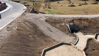
This chunk describes how human surveyors and Spot the robot work together. The surveyors are the ones who plan how Spot should move around the site and what specific data they need him to collect. Once the surveyors do this, Spot takes over and navigates through various types of terrain. As it moves, Spot uses its technology to create detailed three-dimensional scans of the environment, which are essential for monitoring and planning construction projects.
Examples & Analogies
Think of the surveyors as directors of a movie who tell the robotic dog, Spot, what scenes to capture and where to go to get the best angles. Once the plan is made, Spot operates on its own to capture the footage, ensuring every important part of the 'set' is documented perfectly.
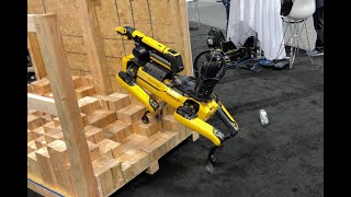
Case: Large-Scale Construction Sites
Chapter 3 of 4
🔒 Unlock Audio Chapter
Sign up and enroll to access the full audio experience
Chapter Content
• Sites in Singapore and Japan using Spot for daily progress monitoring.
Detailed Explanation
In this section, we see real-world applications of Spot's capabilities. Large-scale construction projects in countries like Singapore and Japan have implemented Spot for monitoring daily progress. This means Spot is not only just surveying the area but is actively involved in keeping track of how much work has been completed on these extensive projects.
Examples & Analogies
Imagine Spot as a diligent student who checks off tasks on a construction checklist every day in class. By monitoring progress each day, Spot helps ensure that everything is on track and identifies any parts of the project that might be falling behind, much like a student might notice if their classmates are struggling with an assignment.
Results
Chapter 4 of 4
🔒 Unlock Audio Chapter
Sign up and enroll to access the full audio experience
Chapter Content
• Reduced need for rework due to accurate and consistent progress data.
• Improved communication among stakeholders.
Detailed Explanation
The outcomes of using Spot are significant. First, because Spot gathers precise and consistent data about the construction site, there's a reduced need for rework. This means that mistakes are caught early, saving time and resources. Secondly, having accurate data helps improve communication among all the parties involved in the construction, from engineers to project managers to clients. Everyone is on the same page, which leads to a smoother overall project.
Examples & Analogies
You can think about the results as using a calculator for math homework. When you use it, you get the correct answers the first time, which helps you avoid going back and redoing problems. Similarly, Spot’s accurate data collection allows construction teams to keep their projects running smoothly without needing to fix mistakes later on.
Key Concepts
-
Spot: A quadruped robot used for accurate surveying and data collection.
-
Human-Robot Integration: Collaboration between surveyors and Spot for improved data collection.
-
Daily Progress Monitoring: Utilizing Spot to keep track of project advancements efficiently.
-
Trimble Systems: Advanced surveying tools that enhance Spot's functionality.
Examples & Applications
Spot is used in large-scale construction sites in Singapore and Japan.
Daily monitoring of construction progress helps prevent costly rework.
Memory Aids
Interactive tools to help you remember key concepts
Rhymes
Spot the bot, on site it’ll trot, surveying daily, error it will thwart.
Stories
Once upon a time, there was a robot named Spot who traveled across construction sites, helping surveyors gather data. Spot's precision allowed humans to make better decisions and avoid costly mistakes, showing that teamwork between robots and humans leads to great results.
Memory Tools
Remember 'SMART': Surveyors, Monitoring, Accurate, Reduce-Work, Teamwork.
Acronyms
Use 'SENTRY' to remember Spot
Surveying
Efficient
Navigation
Technology
Reduce rework
Yield results.
Flash Cards
Glossary
- Autonomous Surveying
Surveying conducted with minimal human intervention, using robots or automated systems.
- Quadroped Robot
A robot that walks on four legs, designed for mobility across various terrains.
- Trimble Laser Scanners
Devices used to capture accurate 3D data for surveying applications.
- GPS Systems
Global Positioning Systems used for determining precise locations on Earth.
- HumanRobot Integration
The collaboration between human operators and robotic systems to improve workflow efficiency.
Reference links
Supplementary resources to enhance your learning experience.