
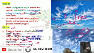
Cirrus
Enroll to start learning
You’ve not yet enrolled in this course. Please enroll for free to listen to audio lessons, classroom podcasts and take practice test.
Interactive Audio Lesson
Listen to a student-teacher conversation explaining the topic in a relatable way.
Introduction to Cirrus Clouds
🔒 Unlock Audio Lesson
Sign up and enroll to listen to this audio lesson

Today, we will learn about cirrus clouds. Have you all ever seen clouds that look thin and feathery in the sky?

Yes, I have! They look different compared to thicker clouds.
Exactly! Cirrus clouds usually form at high altitudes, specifically between 8,000 to 12,000 meters. They are always white because they are made of tiny ice crystals.

Why do they appear white?
Good question! Their white color comes from sunlight scattering off the ice crystals. This scattering makes them visible and gives them their feathery appearance.
Formation of Cirrus Clouds
🔒 Unlock Audio Lesson
Sign up and enroll to listen to this audio lesson

Now, let’s talk about how cirrus clouds actually form. Who can remind us what happens to water vapor at high altitudes?

It freezes when it's really high up because it's cold!
Correct! At high altitudes, the water vapor condenses into ice crystals, and that's how cirrus clouds are formed.

Does that mean they only form in cold weather?
Not necessarily. Water vapor can form clouds like cirrus even in warmer weather conditions, provided it's high enough in the atmosphere.
Significance of Cirrus Clouds
🔒 Unlock Audio Lesson
Sign up and enroll to listen to this audio lesson
Cirrus clouds are not just beautiful; they play an important role in weather forecasting. Can anyone guess how?
Do they tell us if it's going to rain?
That's right! Their appearance can be a sign that a change in weather is coming. They often indicate an approaching storm.
So, they can help meteorologists predict the weather?
Absolutely! By observing cirrus clouds, meteorologists can assess moisture in the upper atmosphere, which helps them predict precipitation and other weather changes.
Cirrus Clouds vs. Other Cloud Types
🔒 Unlock Audio Lesson
Sign up and enroll to listen to this audio lesson
Cirrus clouds are just one type of cloud. Can someone name another type and how it differs?
Cumulus clouds are puffy and look like cotton!
Great example! Unlike cirrus clouds, cumulus clouds form at lower altitudes and can indicate fair weather.
So, cirrus clouds are more about signaling changes in weather than cumulus clouds?
Exactly right! Cirrus clouds often indicate that conditions are changing in the atmosphere, while cumulus clouds often signify stability.
Review and Recap
🔒 Unlock Audio Lesson
Sign up and enroll to listen to this audio lesson
Now that we’ve discussed cirrus clouds in detail, can someone summarize their main characteristics?
They are high-altitude clouds, thin, feathery, and always white.
And they form when water vapor freezes into ice crystals!
Excellent. Remember, these clouds can indicate weather changes. Keep an eye on them!
Will do! I’ll look for them in the sky!
Introduction & Overview
Read summaries of the section's main ideas at different levels of detail.
Quick Overview
Standard
Cirrus clouds, formed between 8,000 to 12,000 meters, are thin, detached, and always white. They signify atmospheric conditions and are important for understanding weather changes, influencing precipitation patterns and temperature.
Detailed
Overview of Cirrus Clouds
Cirrus clouds are the highest type of clouds, typically forming at altitudes ranging from approximately 8,000 to 12,000 meters (or about 26,000 to 39,000 feet). Known for their thin, wispy appearance, these clouds are always white due to their composition of ice crystals that scatter sunlight.
Formation and Characteristics
Cirrus clouds form in high altitudes, where temperatures are low, causing water vapor to freeze into tiny ice crystals. These crystals are so small that they can be blown away by strong winds, contributing to the clouds' detached and fibrous look akin to feathers—hence the name 'cirrus', derived from Latin for 'curl'.
Significance in Weather
Cirrus clouds are often seen as an indicator of upcoming weather changes. Their presence can suggest moisture in the upper atmosphere, which may lead to precipitation or other cloud types forming below as warm air rises.
Conclusion
Understanding cirrus clouds is crucial for meteorologists in predicting short-term weather changes due to their high-altitude formation and role in influencing various atmospheric processes.
Youtube Videos


Audio Book
Dive deep into the subject with an immersive audiobook experience.
Introduction to Cirrus Clouds
Chapter 1 of 4
🔒 Unlock Audio Chapter
Sign up and enroll to access the full audio experience
Chapter Content
Cirrus clouds are formed at high altitudes (8,000 - 12,000m). They are thin and detached clouds having a feathery appearance. They are always white in colour.
Detailed Explanation
Cirrus clouds are types of clouds that form very high in the atmosphere, typically between 8,000 and 12,000 meters. They appear thin and wispy, resembling feathers. Their white color indicates that they are composed of ice crystals, as they form where temperatures are very low. The high altitude at which they exist means they are often seen during clear weather and do not generally indicate precipitation.
Examples & Analogies
Think of cirrus clouds as the gentle brushstrokes of a painter on a canvas, adding a delicate touch to a clear blue sky. Just as a painter uses light colors to create a feeling of brightness and openness, cirrus clouds brighten the atmosphere without blocking out too much sunlight.
Formation of Cirrus Clouds
Chapter 2 of 4
🔒 Unlock Audio Chapter
Sign up and enroll to access the full audio experience
Chapter Content
Cirrus clouds are formed when water vapor in the atmosphere rises to high altitudes where the air is cold. At these heights, the vapor transforms into ice crystals due to the lower temperatures.
Detailed Explanation
The formation of cirrus clouds begins with water vapor rising from the Earth's surface. As the air rises, it cools, and because the temperatures at high altitudes are much lower, this vapor cannot remain as gas. Instead, it condenses into tiny ice crystals. Once sufficient ice crystals accumulate, they create what we see as cirrus clouds. This process is a result of the water cycle, demonstrating how essential temperature is in cloud formation.
Examples & Analogies
Imagine boiling water on a stove. When steam rises and encounters the cooler air above, it transforms into tiny water droplets under specific conditions. Similarly, water vapor rises in the atmosphere and changes into ice crystals, creating the beautiful cirrus clouds we see high above us.
Characteristics of Cirrus Clouds
Chapter 3 of 4
🔒 Unlock Audio Chapter
Sign up and enroll to access the full audio experience
Chapter Content
Cirrus clouds are thin and wispy, often indicating fair weather. However, their presence can also signal that a change in weather is on the way, potentially leading to stormy conditions.
Detailed Explanation
Cirrus clouds are not dense; they allow sunlight to filter through, which makes the sky appear bright and clear. Their presence can suggest that the weather is good; however, meteorologists pay attention to these clouds because they can also form ahead of a storm. This is due to the fact that changes in pressure and temperature aloft can lead to storm systems, and cirrus clouds may form as a precursor to these weather changes.
Examples & Analogies
Picture a weather influencer on social media who posts vibrant, bright images of sunny days. However, if they also start posting pictures of ripening storm clouds in the distance, it may be a sign that a storm is approaching! Cirrus clouds are like the first hint of change—simple and beautiful, but often whispering about the potential for more severe weather ahead.
Significance of Cirrus Clouds
Chapter 4 of 4
🔒 Unlock Audio Chapter
Sign up and enroll to access the full audio experience
Chapter Content
While cirrus clouds generally indicate clear weather, they also play a role in the Earth's climate by reflecting sunlight back into space and helping to heat the atmosphere.
Detailed Explanation
Cirrus clouds have a significant impact on the Earth's climate system. They reflect some sunlight back into space, which can help cool the planet. At the same time, the ice crystals within these clouds can trap heat, preventing it from escaping back into space. This dual role makes cirrus clouds both a cooling and warming factor in the climate system, illustrating the complex balance of our atmosphere.
Examples & Analogies
Think of cirrus clouds as the thermostat of the Earth—sometimes cooling things down by reflecting sunlight, and at other times keeping warmth close to the surface. Just like a well-regulated thermostat maintains a comfortable environment in your home, cirrus clouds help regulate temperature and weather patterns on a global scale.
Key Concepts
-
Cirrus Clouds: High-altitude clouds that indicate changing weather.
-
Ice Crystals: Form the structure of cirrus clouds.
-
Cloud Formation: Process involving condensation of water vapor.
-
Weather Patterns: Cirrus clouds signify potential changes in weather.
Examples & Applications
On a clear day, cirrus clouds may signal that a storm is approaching.
The presence of cirrus clouds can precede the arrival of a warm front.
Memory Aids
Interactive tools to help you remember key concepts
Rhymes
Wispy, feathery, up in the sky, cirrus clouds tell us, changes are nigh.
Stories
Once upon a time, in a blue sky, the cirrus clouds danced high, whispering secrets of weather changes to the earth below.
Memory Tools
C for Cirrus, C for Change - when cirrus appears, be prepared for a rearrange.
Acronyms
C-R-I-S-P
Cirrus clouds
Reaching Ice in Sky Patterns.
Flash Cards
Glossary
- Cirrus Clouds
High altitude clouds that appear thin and wispy, composed of ice crystals.
- Altitude
The height of an object or point in relation to sea level or ground level.
- Moisture
Water vapor present in the air.
- Weather Forecasting
The process of predicting the atmosphere's state using various observations.
- Ice Crystals
Solid forms of water vapor commonly found in clouds at low temperatures.
Reference links
Supplementary resources to enhance your learning experience.