
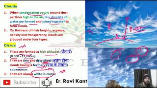
Cumulus
Enroll to start learning
You’ve not yet enrolled in this course. Please enroll for free to listen to audio lessons, classroom podcasts and take practice test.
Interactive Audio Lesson
Listen to a student-teacher conversation explaining the topic in a relatable way.
Introduction to Cumulus Clouds
🔒 Unlock Audio Lesson
Sign up and enroll to listen to this audio lesson

Today, we’re going to learn about cumulus clouds. Can anyone tell me what they look like?

They look like fluffy cotton balls!
Exactly, Student_1! Cumulus clouds often resemble cotton wool. Now, who can tell me how high these clouds typically form?

I think they are formed at around 4,000 to 7,000 meters.
Great job, Student_2! Cumulus clouds form between those heights. They indicate stable weather when they are present. Remember, 'Cumulus = Cotton, Calm Weather'.
Roles of Cumulus Clouds
🔒 Unlock Audio Lesson
Sign up and enroll to listen to this audio lesson

Now that we know what cumulus clouds are, let's talk about their role in weather. Can you think of a weather situation where you might see cumulus clouds?

On a sunny day, I often see them in the sky!
That's right, Student_3! They often indicate fair weather. However, they can develop into larger storm clouds if conditions are right. Can anyone tell me what might cause this transformation?

Maybe if it gets really hot and humid?
Exactly! Warm, moist air can lead to cumulus clouds growing into cumulonimbus clouds, which can bring thunderstorms.
Formation and Lifecycle of Cumulus Clouds
🔒 Unlock Audio Lesson
Sign up and enroll to listen to this audio lesson
Let's dive deeper into how cumulus clouds actually form. What process do you think is involved in their formation?
I think it has something to do with water vapor rising.
Correct, Student_1! It all starts with evaporation, where water turns into vapor. This vapor rises and cools, leading to condensation. We can remember this with the acronym 'CREAM': Cumulonimbus, Rising air, Evaporation, Air cooling, Moisture.
So, these clouds grow when air rises and the moisture condenses?
Exactly! As they grow, they may signal that a storm could be brewing.
Introduction & Overview
Read summaries of the section's main ideas at different levels of detail.
Quick Overview
Standard
This section discusses cumulus clouds, which resemble cotton wool and form at altitudes between 4,000 and 7,000 meters. They play a critical role in weather phenomena and are an indicator of fair weather, albeit they can develop into larger storm clouds under certain conditions.
Detailed
Cumulus Clouds Overview
Cumulus clouds are characterized by their fluffy, cotton-like appearance, typically forming at heights ranging from 4,000 to 7,000 meters above the Earth's surface. These clouds are often associated with fair weather, making them a staple of pleasant sunny days. The formation process begins with water vapor in the atmosphere, which condenses into liquid droplets as warm air rises and cools. Although cumulus clouds usually signal stable weather conditions, they can evolve into larger, more threatening storm clouds under specific atmospheric conditions, such as high humidity and an increase in temperature variations.
Understanding cumulus clouds not only helps us predict weather patterns but also highlights the role of different cloud types in the broader context of meteorology and atmospheric processes.
Youtube Videos


Audio Book
Dive deep into the subject with an immersive audiobook experience.
What Are Cumulus Clouds?
Chapter 1 of 3
🔒 Unlock Audio Chapter
Sign up and enroll to access the full audio experience
Chapter Content
Cumulus clouds look like cotton wool. They are generally formed at a height of 4,000 - 7,000 m. They exist in patches and can be seen scattered here and there. They have a flat base.
Detailed Explanation
Cumulus clouds are fluffy, white clouds that often resemble the shape and texture of cotton balls. They usually form at altitudes between 4,000 and 7,000 meters and are characterized by their flat bases and scattered appearance in the sky. This scattered formation occurs because cumulus clouds develop in areas where warm air rises, allowing them to grow vertically.
Examples & Analogies
Think of cumulus clouds like puffs of cotton candy scattered across a blue sky. Just like how cotton candy is fluffy and light, cumulus clouds are formed from water vapor that has condensed, giving them their soft appearance. When you look up at a sunny day and see those white, puffy clouds, that’s the cumulus cloud at work!
Formation of Cumulus Clouds
Chapter 2 of 3
🔒 Unlock Audio Chapter
Sign up and enroll to access the full audio experience
Chapter Content
Cumulus clouds form due to the rising of warm air, which expands and cools as it rises, leading to condensation of water vapor into droplets.
Detailed Explanation
Cumulus clouds are formed when warm, moist air rises due to convection. As this air rises, it expands and cools. When it cools to its dew point, the water vapor condenses to form tiny water droplets, creating the cloud. This process is a key aspect of weather formation, especially during sunny, warm days when the atmosphere has enough humidity.
Examples & Analogies
Imagine boiling water in a kettle. The steam rises because it’s lighter than air, just like warm air rises to create cumulus clouds. As the steam rises and cools outside the kettle, it condenses into droplets of water—similar to how the water vapor condenses in the atmosphere to form clouds!
Characteristics of Cumulus Clouds
Chapter 3 of 3
🔒 Unlock Audio Chapter
Sign up and enroll to access the full audio experience
Chapter Content
They have distinct characteristics such as being white in color, having a fluffy appearance, and often indicating fair weather, although they can develop into larger storm clouds.
Detailed Explanation
Cumulus clouds are generally characterized by their white color and fluffy, rounded appearance, which gives them a cotton-like look. They typically indicate good weather conditions; however, they have the potential to grow into larger storm clouds, called cumulonimbus, if atmospheric conditions change. These clouds can signal the development of thunderstorms and heavy rain.
Examples & Analogies
Picture a sunny picnic day where you see fluffy white clouds. This is usually a signal that the weather will remain pleasant. However, if you notice those clouds getting darker and taller, like they are puffing up, it's like them putting on a sweater—the clouds may be getting ready to release rain!
Key Concepts
-
Cumulus Clouds: These are cotton-like clouds that signify fair weather.
-
Cloud Formation: Cumulus clouds form from rising warm air and condensation of water vapor.
-
Weather Indicators: The presence of cumulus clouds often suggests stable weather, but can signal storms if they grow larger.
Examples & Applications
Cumulus clouds can often be seen on sunny days, creating a picturesque sky.
When cumulus clouds grow larger and darker, they can indicate an incoming thunderstorm.
Memory Aids
Interactive tools to help you remember key concepts
Rhymes
Cumulus clouds so fluffy and bright, signal good weather and a lovely sight.
Stories
Once upon a sunny day, cumulus clouds danced in the blue sky, foreshadowing a day of picnics and fun.
Memory Tools
Use the acronym COTTON: Cumulus, Often indicates, Tranquility, Temperature, Outstandingly Nice.
Acronyms
C.E.C. = Cumulus, Evaporation, Condensation.
Flash Cards
Glossary
- Cumulus
Fluffy, white clouds typically formed at altitudes of 4,000 to 7,000 meters, indicating fair weather.
- Condensation
The process by which water vapor changes into liquid water, often forming clouds.
- Evaporation
The process of liquid water turning into water vapor, enabling cloud formation.
- Cumulonimbus
A type of cloud that can form from cumulus clouds, associated with thunderstorms.
Reference links
Supplementary resources to enhance your learning experience.