
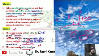
Clouds
Enroll to start learning
You’ve not yet enrolled in this course. Please enroll for free to listen to audio lessons, classroom podcasts and take practice test.
Interactive Audio Lesson
Listen to a student-teacher conversation explaining the topic in a relatable way.
Introduction to Clouds
🔒 Unlock Audio Lesson
Sign up and enroll to listen to this audio lesson

Today we will talk about clouds! Can anyone tell me what clouds are?

Clouds are those white fluffy things in the sky, right?
Exactly! Clouds are made of tiny water droplets or ice crystals. They form when water vapor in the air cools and condenses. Who can explain the process of evaporation?

Evaporation happens when water turns into vapor, usually when it heats up!
Great job! Remember, evaporation is the first step in forming clouds. Let's discuss how temperature affects this process.
Types of Clouds
🔒 Unlock Audio Lesson
Sign up and enroll to listen to this audio lesson

Now, let's talk about the different types of clouds. We have cirrus, cumulus, stratus, and nimbus. What is a cirrus cloud?

I think they are high-up, thin, and look like feathers.
That's correct! Cirrus clouds are high-altitude clouds. How about cumulus clouds?

They look puffy like cotton balls!
Exactly! Cumulus clouds are fluffy and usually indicate good weather. Let's also remember that nimbus clouds are thick and grey, often bringing rain.
The Process of Condensation
🔒 Unlock Audio Lesson
Sign up and enroll to listen to this audio lesson
We've covered what clouds are, now let's move on to how they form through condensation. What happens during this process?
Condensation is when water vapor cools and turns back into liquid!
That's exactly right! And condensation often happens around tiny particles in the air called nuclei. Can anyone name some examples of nuclei?
Dust or smoke particles!
Fantastic! These particles are essential for forming clouds. Remember, as air cools, if it reaches a point called the dew point, that's when condensation occurs.
Precipitation
🔒 Unlock Audio Lesson
Sign up and enroll to listen to this audio lesson
After clouds form, they can lead to precipitation. What are some forms of precipitation you all know?
Rain and snow!
Yes! Precipitation can be rain, snow, sleet, or hail, depending on the temperature during condensation. What do we call the process when water droplets in the cloud become heavy enough to fall?
That's called precipitation!
Correct! Remember, precipitation varies by conditions in the atmosphere. Let's summarize what we have learned today.
Introduction & Overview
Read summaries of the section's main ideas at different levels of detail.
Quick Overview
Standard
This section explores the formation of clouds, the processes of evaporation and condensation, the types of clouds (cirrus, cumulus, stratus, and nimbus), and the concept of precipitation resulting from these processes. Each cloud type has distinct characteristics influenced by temperature, altitude, and moisture content.
Detailed
Clouds
Clouds are essential components of the Earth's atmosphere, formed by the condensation of water vapor into tiny water droplets or ice crystals. This happens at considerable elevations, where various factors such as temperature, humidity, and air movement play pivotal roles.
Formation of Clouds
Clouds form through a process that begins with evaporation from water bodies and transpiration from plants. Water vapor enters the atmosphere, and when it cools, it condenses due to loss of heat, especially around microscopic particles, forming clouds. The air can become saturated with moisture, leading to different types of clouds based on their altitude, density, and transparency.
Types of Clouds
- Cirrus: High-altitude clouds (8,000 - 12,000 m) appearing thin and wispy.
- Cumulus: Fluffy, white clouds resembling cotton, generally formed at 4,000 - 7,000 m.
- Stratus: Layered clouds covering vast portions of the sky, often signaling overcast weather.
- Nimbus: Thick, dark gray clouds that indicate precipitation, often low and dense.
Precipitation
The continuous condensation of water vapor leads to precipitation, which can manifest as rain, snow, sleet, or hail, depending on temperature and other atmospheric conditions. Each type of precipitation is influenced by mechanisms such as convection, orographic lifting, and cyclonic activity.
Understanding clouds and their types is crucial in meteorology as they influence weather patterns and climate.
Youtube Videos


Audio Book
Dive deep into the subject with an immersive audiobook experience.
What are Clouds?
Chapter 1 of 6
🔒 Unlock Audio Chapter
Sign up and enroll to access the full audio experience
Chapter Content
Cloud is a mass of minute water droplets or tiny crystals of ice formed by the condensation of the water vapour in free air at considerable elevations.
Detailed Explanation
Clouds are made of tiny droplets of water or ice crystals that form when water vapor in the air cools and condenses. This occurs at various heights above the Earth's surface, resulting in different types of clouds with various forms and characteristics.
Examples & Analogies
Think of clouds like cotton candy that forms in the sky. Just like how sugar can clump together to form sugary clouds at a carnival, water vapor in the air condenses to create fluffy clouds in the atmosphere.
Classification of Clouds
Chapter 2 of 6
🔒 Unlock Audio Chapter
Sign up and enroll to access the full audio experience
Chapter Content
According to their height, expanse, density and transparency or opaqueness clouds are grouped under four types : (i) cirrus; (ii) cumulus; (iii) stratus; (iv) nimbus.
Detailed Explanation
Clouds are categorized based on their characteristics such as height and appearance. The four main types include:
1. Cirrus - high, thin, feathery clouds.
2. Cumulus - fluffy, cotton-like clouds typically seen in fair weather.
3. Stratus - flat, layered clouds that cover the sky.
4. Nimbus - dark, thick clouds associated with rain.
Examples & Analogies
Imagine clouds like different types of clothing. Cirrus clouds are like a light scarf high in the sky; cumulus clouds are like a warm sweater; stratus clouds resemble a cozy blanket, covering everything; and nimbus clouds are like a raincoat, ready to pour rain.
Cirrus Clouds
Chapter 3 of 6
🔒 Unlock Audio Chapter
Sign up and enroll to access the full audio experience
Chapter Content
Cirrus clouds are formed at high altitudes (8,000 - 12,000m). They are thin and detached clouds having a feathery appearance. They are always white in colour.
Detailed Explanation
Cirrus clouds are high-altitude clouds, forming above 8,000 meters. They appear wispy and thin, often looking like streaks or feathers across the sky. Their white color is due to the ice crystals that make them up, which reflect sunlight.
Examples & Analogies
If you ever see feathery clouds high in the sky, think of them as nature's artwork. They're like the delicate brush strokes of a painter who wants to create a soft and beautiful sky.
Cumulus Clouds
Chapter 4 of 6
🔒 Unlock Audio Chapter
Sign up and enroll to access the full audio experience
Chapter Content
Cumulus clouds look like cotton wool. They are generally formed at a height of 4,000 - 7,000 m. They exist in patches and can be seen scattered here and there. They have a flat base.
Detailed Explanation
Cumulus clouds are fluffy and white clouds that often look like big puffs of cotton candy. They typically form between 4,000 and 7,000 meters in the sky and have a characteristic flat base. They are often associated with fair weather.
Examples & Analogies
Imagine you’re at a park and you see soft, white fluff scattered in the sky. Those cumulus clouds look like pillows of cotton, perfect for daydreaming while lying on the grass.
Stratus Clouds
Chapter 5 of 6
🔒 Unlock Audio Chapter
Sign up and enroll to access the full audio experience
Chapter Content
As their name implies, these are layered clouds covering large portions of the sky. These clouds are generally formed either due to loss of heat or the mixing of air masses with different temperatures.
Detailed Explanation
Stratus clouds are uniform, gray clouds that cover the entire sky like a blanket. They form when air cools and loses heat, or when different air masses with varying temperatures mix together. This type of cloud can bring light rain or drizzle.
Examples & Analogies
Think of stratus clouds as a cozy, gray quilt that covers your bed. They wrap around the sky uniformly, creating a soft, muted atmosphere, often bringing gentle rain, much like a comforting drizzle from a warm shower.
Nimbus Clouds
Chapter 6 of 6
🔒 Unlock Audio Chapter
Sign up and enroll to access the full audio experience
Chapter Content
Nimbus clouds are black or dark gray. They form at middle levels or very near to the surface of the earth. These are extremely dense and opaque to the rays of the sun. Sometimes, the clouds are so low that they seem to touch the ground.
Detailed Explanation
Nimbus clouds are thick, dark clouds that are usually associated with rain and storms. They can form at mid-level heights or close to the ground and are so dense that they block sunlight. Their appearance often signals incoming precipitation.
Examples & Analogies
Imagine a big storm cloud hovering ominously above you, like a heavy blanket ready to burst. Nimbus clouds might remind you of colanders filled with batter, waiting to drizzle down rain like sweet syrup on a pancake.
Key Concepts
-
Cloud Formation: The process of condensation of water vapor into clouds.
-
Types of Clouds: Four primary types of clouds - cirrus, cumulus, stratus, and nimbus, each with distinct characteristics.
-
Precipitation: The release of condensed water from clouds in forms such as rain, snow, sleet, or hail.
Examples & Applications
Cirrus clouds are often seen on clear days and indicate fair weather.
Cumulus clouds develop in fair weather but can turn into storm clouds.
Rainfall is the most common form of precipitation experienced globally.
Memory Aids
Interactive tools to help you remember key concepts
Rhymes
Clouds in the sky, so fluffy and white, hold rain and snow, what a magical sight!
Stories
Imagine a drop of water floating up into the sky, where it meets cool air, transforms into a cloud, and eventually returns to Earth as rain.
Memory Tools
C-C-C-N: Cirrus, Cumulus, Stratus, Nimbus - the clouds we classify.
Acronyms
C.D.P (Cloud, Dew, Precipitation) helps us remember the water cycle.
Flash Cards
Reference links
Supplementary resources to enhance your learning experience.