
Plotting Palaces, Temples and Bazaars
Enroll to start learning
You’ve not yet enrolled in this course. Please enroll for free to listen to audio lessons, classroom podcasts and take practice test.
Interactive Audio Lesson
Listen to a student-teacher conversation explaining the topic in a relatable way.
Discovery and First Documentation
🔒 Unlock Audio Lesson
Sign up and enroll to listen to this audio lesson

Today we will begin discussing how the ruins of the Vijayanagara Empire were first documented. Can anyone tell me who was one of the first individuals to map the site?

Was it Colonel Colin Mackenzie?
Yes, exactly! Mackenzie was sent by the British East India Company and he began mapping the area in 1800. He relied heavily on the oral histories from local priests. This brings us to our memory aid: 'Mackenzie and the Map' – it helps us remember he's the first mapper of Vijayanagara.

What did he find out from the priests?
Great question! The priests provided key insights into the temples and community traditions, allowing him to understand the significance of various structures. Do you remember any specific temples they discussed?

Wasn't there the Virupaksha temple?
Yes! The Virupaksha temple is a central piece in understanding Vijayanagara's culture. Mackenzie’s maps were foundational for future scholars.
To summarize, Colonel Mackenzie was pivotal in the exploration of Vijayanagara by mapping out the sites based on oral traditions from temple priests.
Role of Photography and Epigraphy
🔒 Unlock Audio Lesson
Sign up and enroll to listen to this audio lesson

Moving on, can anyone tell me how photography contributed to our understanding of Vijayanagara?

I think photographers started recording images of the monuments very early on, around 1856?
Exactly right! This era marked a significant advancement in documenting architectural details. Now, who knows what role inscriptions played in this documentation?
Inscriptions helped historians understand the history and significance of the temples, right?
Absolutely! The inscriptions provided valuable context about the people who built and used these structures. Let's use the acronym 'PIE' – Photography, Inscriptions, Exploration – to remember these key sources of historical evidence.
To conclude today's session, we have seen how early photography and inscriptions formed a framework for developing a deeper understanding of the Vijayanagara Empire.
Comprehensive Mapping Efforts
🔒 Unlock Audio Lesson
Sign up and enroll to listen to this audio lesson
Now let's talk about the comprehensive mapping efforts that took place later. Who wants to start with how the surveys were organized?
They divided the area into squares for easier mapping, right?
Very good! They designated squares with letters and then divided them further. This systematic approach revealed thousands of structures and paths.
Did they find just temples?
No, they discovered all sorts of structures, including pathways and bazaars, which were essential for understanding the urban layout. To help remember this, think of 'CAP' – Comprehensive, Ancient, and Paths.
In summary, the meticulous mapping allowed researchers to rediscover not only temples but an entire urban civilization's network.
Importance of Bazaars
🔒 Unlock Audio Lesson
Sign up and enroll to listen to this audio lesson
Today we are focusing on the role of bazaars within Vijayanagara. Why do you think bazaars were crucial?
Because they are where trade happens, right? It’s how the economy thrived?
Exactly! Bazaars like those described by travelers were bustling with various goods, promoting commerce, which is vital for any civilization. Let's create a rhyme: 'In bazaars, the goods shine bright, bustling trade from morning till night!'
What kinds of items were specifically traded in Vijayanagara’s bazaars?
They traded precious stones, textiles, and spices, which were highly sought after. Remember, 'Gems, Goods, and Greens' helps encapsulate these main trading items!
In conclusion, the bazaars were a lifeline for the economy of Vijayanagara, providing a space for vibrant trade and cultural exchange.
Holistic Integration of Findings
🔒 Unlock Audio Lesson
Sign up and enroll to listen to this audio lesson
Let's wrap up our studies by discussing the holistic integration of findings from the research at Vijayanagara. Why is it important to combine different sources of information?
To get a full picture of what life was like back then?
Exactly! By integrating archaeological finds, travelers' accounts, and inscriptions, we can gain a multifaceted understanding of Vijayanagara’s society. To recall this, think of 'MATERIAL' – Mapping, Accounts, Traditions, Inscriptions, Archaeological, Research, Life.
Is that what researchers are still working on today?
Yes, indeed! Researchers are still uncovering stories and gaining insights from these combined sources. To summarize, the holistic approach allows us to understand complex histories like that of Vijayanagara.
Introduction & Overview
Read summaries of the section's main ideas at different levels of detail.
Quick Overview
Standard
This section explores the various methods used to document Vijayanagara's architectural heritage, highlighting the role of mapping in the preservation of historical sites. It elaborates on the collaborative efforts undertaken since the 19th century to understand the city's layout and its cultural significance, particularly in relation to the bazaars and temples.
Detailed
Detailed Summary
The Vijayanagara Empire, known for its opulence and architectural prowess, left behind significant ruins that have been the subject of extensive study and documentation. This section outlines the various stages of scholarly work beginning with the early surveys led by Colonel Colin Mackenzie in 1800, who first mapped the site, drawing on the oral history provided by temple priests. Over the years, the Archaeological Survey of India and other organizations conducted systematic surveys, resulting in detailed documentation of the material remains of the once-thriving city. In 1976, Hampi was recognized as a site of national importance.
The meticulous mapping process involved dividing the area into squares, facilitating a thorough examination of the layout, which included a wide array of structures such as tiny shrines, grand temples, and bustling bazaars. The accounts from travelers like Domingo Paes helped paint a vivid picture of the city's vibrancy through descriptions of daily life, trade, and the various goods available in its markets. Overall, the integration of archaeological evidence with historical narratives has provided scholars with an insightful understanding of Vijayanagara's role in South Asian history, particularly its urban and cultural dynamics.
Youtube Videos


Audio Book
Dive deep into the subject with an immersive audiobook experience.
Methods of Studying Vijayanagara
Chapter 1 of 5
🔒 Unlock Audio Chapter
Sign up and enroll to access the full audio experience
Chapter Content
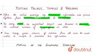
We have been examining a wealth of information on Vijayanagara – photographs, plans, elevations of structures and sculpture. How was all of this produced? After the initial surveys by Mackenzie, information was pieced together from travellers’ accounts and inscriptions. Through the twentieth century, the site was preserved by the Archaeological Survey of India and the Karnataka Department of Archaeology and Museums. In 1976, Hampi was recognised as a site of national importance. Then, in the early 1980s, an important project was launched to document the material remains at Vijayanagara in detail, through extensive and intensive surveys, using a variety of recording techniques. Over nearly twenty years, dozens of scholars from all over the world worked to compile and preserve this information.
Detailed Explanation
The study of Vijayanagara included various methods such as initial surveys by Colonel Colin Mackenzie, who documented much of the site in the early 1800s. His work was subsequently complemented by traveler accounts and inscriptions, which provided historical context. The ongoing efforts of the Archaeological Survey of India preserved the site and recognized its significance. In the 1980s, a detailed project began, where scholars used advanced techniques to document the remains of structures including temples, residential areas, and bazaars. This meticulous survey work has taken nearly two decades, illustrating the collaborative nature of historical research and the importance of different types of evidence.
Examples & Analogies
Imagine a treasure hunt where each clue leads to the discovery of a piece of a puzzle. Historical research functions similarly, piecing together various forms of evidence like inscriptions, photographs, and traveler descriptions to form a comprehensive understanding of a lost civilization. Just as each clue can lead to new insights, each piece of evidence about Vijayanagara reveals deeper layers of its history and culture.
Mapping the City
Chapter 2 of 5
🔒 Unlock Audio Chapter
Sign up and enroll to access the full audio experience
Chapter Content
Let us look at just one part of this enormous exercise – mapping – in more detail. The first step was to divide the entire area into a set of 25 squares, each designated by a letter of the alphabet. Then, each of the small squares was subdivided into a set of even smaller squares. But this was not all: each of these smaller squares was further subdivided into yet smaller units.
Detailed Explanation
Mapping Vijayanagara involved a systematic approach to understand the layout of the city. The scholars began by dividing the entire area into 25 large squares, marking them with letters for easy identification. This method of subdivision continued, with each larger square being further divided into smaller squares, which allowed for a detailed analysis of the site. This level of detailed mapping helps archaeologists and historians locate specific structures within the larger archaeological landscape, facilitating a clearer understanding of urban organization and spatial relationships.
Examples & Analogies
Think of it like organizing your clothes in a wardrobe. You start with different sections (like tops, bottoms, and accessories), then further divide each section into specific categories (like t-shirts, jeans, belts). This helps you find what you need quickly. Similarly, mapping a historical site like Vijayanagara helps researchers locate and study various structures and features efficiently.
Preservation and Excavation
Chapter 3 of 5
🔒 Unlock Audio Chapter
Sign up and enroll to access the full audio experience
Chapter Content
As you can see, these detailed surveys have been extremely painstaking, and have recovered and documented traces of thousands of structures – from tiny shrines and residences to elaborate temples. They have also led to the recovery of traces of roads, paths, bazaars, etc.
Detailed Explanation
The surveys conducted at Vijayanagara were not just about mapping but also about uncovering the history beneath the ground. Scholars meticulously excavated the area to find remnants of various structures, including small shrines, homes, and temples, which were crucial in understanding the life of the inhabitants. The documentation of roads and bazaars also provided insights into the city's trade and daily activities, showcasing the urban infrastructure that supported its vibrant economy.
Examples & Analogies
Imagine an archaeology team digging at a famous historical site, much like a team of detectives unearthing clues for a mystery. Each structure they find tells a different story about how people lived, traded, and interacted centuries ago. Just as detectives piece together evidence to solve a case, archaeologists piece together physical remnants to reconstruct the everyday life of the people who thrived in Vijayanagara.
Imagining the Past
Chapter 4 of 5
🔒 Unlock Audio Chapter
Sign up and enroll to access the full audio experience
Chapter Content
It is worth remembering something that John M. Fritz, George Michell and M.S. Nagaraja Rao, who worked for years at the site, wrote: “In our study of these monuments of Vijayanagara we have to imagine a whole series of vanished wooden elements – columns, brackets, beams, ceilings, overhanging eaves, and towers – decorated with plaster and painted, perhaps brightly.”
Detailed Explanation
The work of historians and archaeologists often requires them to imagine what has been lost over time. In Vijayanagara, many structures were made of wood, which has not survived the centuries. However, through their extensive studies, scholars hypothesize about missing features based on the architectural styles and remnants they find, envisioning grand buildings that were once richly adorned. This kind of imaginative reconstruction is essential for understanding how the city may have looked and felt during its peak.
Examples & Analogies
Think of reading a story where the author describes a beautiful garden. Even if the illustrations are not provided, the vivid descriptions enable you to visualize the scenes in your mind. Similarly, researchers create mental images of Vijayanagara based on the evidence remaining, helping us understand how remarkably grand and vibrant the city once was.
Descriptions of the Bazaar
Chapter 5 of 5
🔒 Unlock Audio Chapter
Sign up and enroll to access the full audio experience
Chapter Content
Paes gives a vivid description of the bazaar: "Going forward, you have a broad and beautiful street … In this street live many merchants, and there you will find all sorts of rubies, and diamonds, and emeralds, and pearls, and seed-pearls, and cloths, and every other sort of thing there is on earth and that you may wish to buy."
Detailed Explanation
The bazaars of Vijayanagara were bustling centers filled with a diverse array of goods. According to the accounts of the traveler Paes, the streets were not just wide and beautiful but also vibrant with merchants selling precious stones, textiles, and various commodities. This description highlights the economic significance of the bazaars, indicating that Vijayanagara was a hub of trade and commerce, attracting merchants and buyers from various regions.
Examples & Analogies
Think of a modern market or shopping mall where different stalls and shops showcase diverse products, from fresh fruits and vegetables to luxury items. The bazaar in Vijayanagara functioned on a similar principle, bustling with activity and bringing together a variety of products, reflecting not only trade but cultural exchanges as well.
Key Concepts
-
Mapping: The systematic approach to document and understand historical sites using organized squares.
-
Inscriptions: Important historical records inscribed on temple walls providing context about past societies.
-
Bazaars: Central to Vijayanagara’s economy, serving as vibrant marketplaces contributing to its prosperity.
Examples & Applications
Colonel Colin Mackenzie's early surveys set the foundation for historical mapping of Vijayanagara's ruins.
Bazaars in Vijayanagara were described by travelers as bustling centers of trade filled with precious gems and goods.
Memory Aids
Interactive tools to help you remember key concepts
Rhymes
At Hampi’s ruins, trade shines bright, gems and spices, day and night.
Stories
Imagine being a traveler in Vijayanagara, crossing lively bazaars filled with scents of spices while admiring temples with colorful inscriptions telling tales of ancient history.
Memory Tools
Think of 'MAP' for Mappers (Mackenzie), Accounts (photography), and Preservation (archaeology).
Acronyms
Remember 'IBM' - Inscriptions, Bazaars, Mappings to highlight the key documentation aspects.
Flash Cards
Glossary
- Vijayanagara Empire
An empire founded in the 14th century in India renowned for its wealth and architecture.
- Mappings
The act of creating detailed representations of geographical areas.
- Inscriptions
Carvings or writings found on temples that provide historical context and data.
- Bazaars
Traditional marketplaces where goods and services are exchanged, crucial for local economies.
Reference links
Supplementary resources to enhance your learning experience.