
Site-Specific Peak Acceleration Estimation
Enroll to start learning
You’ve not yet enrolled in this course. Please enroll for free to listen to audio lessons, classroom podcasts and take practice test.
Interactive Audio Lesson
Listen to a student-teacher conversation explaining the topic in a relatable way.
Introduction to Site-Specific PGA Estimation
🔒 Unlock Audio Lesson
Sign up and enroll to listen to this audio lesson

Today, we will discuss site-specific peak acceleration estimation. Why do you think it's essential to consider local conditions when assessing seismic hazards?

Because different locations can experience different levels of shaking due to their geological features!
Exactly! And recognizing those features is critical. We begin by identifying seismic sources. Can someone tell me what we mean by 'seismic sources'?

I think it refers to the locations where earthquakes are likely to occur, like fault lines.
Correct! Understanding these sources helps us assess what kind of motion we might expect during an earthquake.
Ground Motion Prediction Equations (GMPEs)
🔒 Unlock Audio Lesson
Sign up and enroll to listen to this audio lesson

Now, let’s talk about Ground Motion Prediction Equations or GMPEs. Who can explain their significance?

GMPEs help predict how strong the shaking will be at a site depending on factors like the earthquake's magnitude and distance from it.
Great job! Exactly, and selecting the appropriate GMPE is crucial for accurate predictions. What might happen if we choose the wrong one?

It could lead to underestimating or overestimating the expected ground shaking, which might compromise building safety!
Exactly! Hence, we must select GMPEs based on local geological and seismic conditions.
Local Site Class Considerations
🔒 Unlock Audio Lesson
Sign up and enroll to listen to this audio lesson
Our next key point is considering local site classes. Who can tell me what affects the site classification?
The type of soil and geology at the site!
Correct! Soft soils generally amplify seismic waves more than rocky terrains. How does that affect our PGA estimation?
If the site is on soft soil, the PGA would be higher due to that amplification?
Precisely! Thus, it’s essential to include these factors when planning structures.
Probabilistic vs Deterministic Approaches
🔒 Unlock Audio Lesson
Sign up and enroll to listen to this audio lesson
Finally, let’s discuss hazard modeling approaches: probabilistic and deterministic. Who can explain the difference?
Probabilistic considers many potential earthquakes over time, while deterministic looks at specific scenarios.
Exactly! Probabilistic models give us a range of possible outcomes, whereas deterministic models provide a specific level of shaking expected from a defined earthquake. Why might we choose one over the other?
Probabilistic gives a broader picture for planning, while deterministic could be helpful for targeted design against expected catastrophic events.
Very well said! Each method has its place depending on the project's needs.
Creating PGA Maps
🔒 Unlock Audio Lesson
Sign up and enroll to listen to this audio lesson
As a culmination of site-specific PGA estimation, we create PGA maps. Why do you think these maps are essential?
They help engineers understand how strong the shaking could be across different areas, right?
Exactly! And they assist in resource allocation for infrastructure developments and safety planning.
These maps can go down to city-block levels, which is very precise!
Exactly. The resolution aids in targeted planning to mitigate seismic risks effectively.
Introduction & Overview
Read summaries of the section's main ideas at different levels of detail.
Quick Overview
Standard
Site-specific peak acceleration estimation is essential for tailoring seismic assessments and engineering designs to local conditions. This requires identifying seismic sources, choosing appropriate GMPEs, considering local site classes, and potentially employing probabilistic or deterministic hazard modeling.
Detailed
Site-Specific Peak Acceleration Estimation
Estimating Peak Ground Acceleration (PGA) at specific sites is crucial for accurately assessing seismic hazards tailored to local geographical conditions. This involves several key steps:
- Identification of Seismic Sources: It is vital to recognize the active fault lines or seismic zones near the location of interest. Understanding seismic sources helps in predicting possible ground motion impacts during an earthquake.
- Selection of Appropriate GMPEs: Ground Motion Prediction Equations are mathematical models that estimate expected ground movements based on various seismic parameters like earthquake magnitude and distance from the seismic source. Choosing the correct GMPE based on regional characteristics is essential for ensuring the reliability of the predictions.
- Consideration of Local Site Class: The classification of local geological conditions (as per NEHRP/IS 1893) informs how ground motions will be amplified or attenuated based on soil properties. Locations built on soft soils may experience greater amplification of seismic waves compared to sites on rock.
- Probabilistic or Deterministic Hazard Modeling: This modeling assesses the likelihood of different ground shaking levels over specified time frames. Such approaches can include probabilistic models, which evaluate the probabilities of various seismic events, or deterministic models, focusing on specific earthquake scenarios.
The culmination of these processes enables the creation of PGA maps that provide high-resolution assessments suited for engineering applications, often developed through detailed microzonation studies.
Youtube Videos


Audio Book
Dive deep into the subject with an immersive audiobook experience.
Identification of Seismic Sources
Chapter 1 of 5
🔒 Unlock Audio Chapter
Sign up and enroll to access the full audio experience
Chapter Content
Requires identification of seismic sources.
Detailed Explanation
The first step in estimating site-specific peak acceleration is identifying seismic sources, which are areas where earthquakes are likely to occur. This includes understanding the location of fault lines, historical seismic activity, and potential triggering factors of earthquakes in a particular region. By knowing where earthquakes can start, engineers can better estimate the peak acceleration that could be expected at a specific site based on its proximity to these sources.
Examples & Analogies
Imagine this like understanding how close you are to a thunderstorm. If you know a thunderstorm is likely to develop in a certain area (the seismic source), you can prepare for it better. Similarly, by identifying seismic sources, engineers can prepare structures to withstand potential ground shaking.
Selection of Ground Motion Prediction Equations (GMPEs)
Chapter 2 of 5
🔒 Unlock Audio Chapter
Sign up and enroll to access the full audio experience
Chapter Content
Requires selection of appropriate GMPEs.
Detailed Explanation
After identifying the seismic sources, the next step is to select appropriate GMPEs. These equations allow engineers to estimate the expected peak ground acceleration from an earthquake based on various factors, including the earthquake's magnitude, distance from the seismic source, and local site conditions. GMPEs are developed from extensive research and empirical data from past earthquakes, providing a statistical basis for predictions.
Examples & Analogies
Think of GMPEs as recipes based on past experiences. Just like a chef uses a recipe to predict the outcome of a dish based on the ingredients available, engineers use GMPEs to predict ground motion by using data on previous earthquakes and local geology.
Consideration of Local Site Class
Chapter 3 of 5
🔒 Unlock Audio Chapter
Sign up and enroll to access the full audio experience
Chapter Content
Requires consideration of local site class (as per NEHRP/IS 1893).
Detailed Explanation
Local site class refers to the classification of the site based on its soil and geological conditions. This classification is important because the type of ground (such as soft soil versus hard rock) can significantly affect how seismic waves are amplified. According to standards like NEHRP (National Earthquake Hazards Reduction Program) and IS 1893, different site classes have specific characteristics that influence seismic performance and peak ground acceleration estimates. Understanding the site's classification helps tailor the design for better safety.
Examples & Analogies
Imagine you are building a sandcastle. If you build it on wet sand, it's more stable but won't stand well on dry sand, which crumbles away. Similarly, understanding whether a site is on soft soil or hard rock helps engineers determine the best way to build structures that withstand earthquakes.
Probabilistic or Deterministic Hazard Modeling
Chapter 4 of 5
🔒 Unlock Audio Chapter
Sign up and enroll to access the full audio experience
Chapter Content
Requires probabilistic or deterministic hazard modeling.
Detailed Explanation
The final step in site-specific peak acceleration estimation involves either probabilistic or deterministic hazard modeling. Probabilistic models estimate the likelihood of different levels of ground shaking occurring over time, based on historical data and seismic source characteristics. Deterministic models, on the other hand, compute the expected ground shaking from specific seismic events. Both methods help engineers predict peak ground acceleration under various scenarios, providing a comprehensive understanding of earthquake risks at the site.
Examples & Analogies
It's like preparing for a storm. You can either look at weather patterns over time to estimate how often storms happen (probabilistic), or you can watch a specific storm that is currently approaching (deterministic). Both ways help you decide how to prepare your structure for potential impacts from earthquakes.
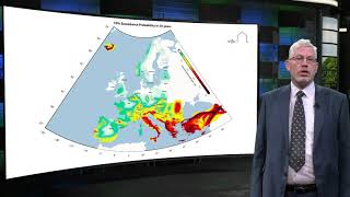
Microzonation Studies and PGA Maps
Chapter 5 of 5
🔒 Unlock Audio Chapter
Sign up and enroll to access the full audio experience
Chapter Content
Microzonation studies often present PGA maps with resolution down to city-block level.
Detailed Explanation
Microzonation studies analyze how local geological conditions affect ground shaking. These studies generate detailed PGA maps that can show variations in expected peak ground acceleration even within a small geographic area, such as a city block. Such localized information is crucial for urban planning and engineering because it allows for tailored designs that consider distinct seismic hazards in specific locations.
Examples & Analogies
Imagine you are hiking in a region with different terrains like hills, valleys, and flat ground. Each area will feel different during an earthquake. Just as specific maps help hikers navigate different terrains, PGA maps help engineers understand the unique seismic risks in each part of a city.
Key Concepts
-
Seismic Sources: Locations of active faults where earthquakes are likely to occur.
-
GMPEs: Tools that estimate ground motion based on regional and magnitude-related characteristics.
-
Local Site Class: Classification based on site soil and geological conditions affecting seismic response.
-
Hazard Modeling: Methodologies assessing possible earthquake scenarios and their impacts.
Examples & Applications
If a site is located near an active fault line, the seismic source would be crucial to consider for estimating PGA.
Using a GMPE specific to the region's soil conditions can enhance the accuracy of the PGA estimation.
Research has shown that soft soil may amplify ground motions significantly, illustrating the need for local site classification.
Memory Aids
Interactive tools to help you remember key concepts
Rhymes
For ground motion prediction, don’t forget GMPEs, they help us know the shakes, so we build with ease.
Stories
Imagine a detective assessing an earthquake scene. They first look for clues (the seismic sources), then decide which lead to follow (GMPEs), ensuring their investigation is accurate (site class considerations) before predicting where danger might lurk (hazard modeling).
Memory Tools
S-G-M-P for remembering: S = Sources, G = GMPEs, M = Modeling (probabilistic/deterministic), P = Prediction.
Acronyms
H-S-M for Hazard Site Mapping
for Hazard
for Site Conditions
for Modeling Approaches.
Flash Cards
Glossary
- Peak Ground Acceleration (PGA)
The maximum acceleration experienced by the ground during an earthquake.
- Ground Motion Prediction Equations (GMPEs)
Mathematical models used to estimate expected ground motion during seismic events.
- Microzonation
The process of dividing an area into sections that have relatively uniform seismic characteristics.
- Probabilistic Hazard Modeling
An approach that assesses the likelihood of various ground shaking scenarios over time.
- Deterministic Hazard Modeling
An approach that focuses on specific earthquake scenarios and their expected outcomes.
- Site Class
Classification of geological conditions that influence ground motion response.
Reference links
Supplementary resources to enhance your learning experience.