
Seismic Zoning and Zoning Maps
Enroll to start learning
You’ve not yet enrolled in this course. Please enroll for free to listen to audio lessons, classroom podcasts and take practice test.
Interactive Audio Lesson
Listen to a student-teacher conversation explaining the topic in a relatable way.
Introduction to Seismic Zoning
🔒 Unlock Audio Lesson
Sign up and enroll to listen to this audio lesson

Today, we're diving into seismic zoning and how it impacts building design in India. Seismic zones help us identify areas based on their earthquake risk.

So, what are the different seismic zones in India?
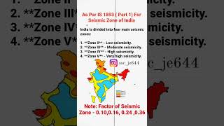
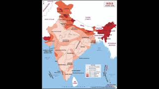
India has four seismic zones: II, III, IV, and V. Each zone indicates a specific level of seismic risk, from least to most severe.

What about Zone I? I have read about it before.
Great question! Zone I was actually removed from the classification as per IS 1893:2002. Now we focus on the four remaining zones.

How does this zoning affect building design?
Excellent point! Each zone has specific factors that guide engineers in the design process. Let's remember the acronym Z for Zone Factor which represents peak ground acceleration.

Can you give us an example of the zone factors?
Sure! For Zone II, the Zone Factor is 0.10, while for Zone V, it's 0.36. This means structures in Zone V should be designed to withstand more intense shaking.
In summary, seismic zoning is crucial for understanding earthquake risks and guides the safe design of structures.
Understanding Zone Factors
🔒 Unlock Audio Lesson
Sign up and enroll to listen to this audio lesson

Now let's discuss zone factors in detail. Who remembers what the zone factor represents?
Is it related to the peak ground acceleration?
Exactly! The zone factor represents the peak ground acceleration expected during a Maximum Considered Earthquake (MCE) for that zone. This guides the design strength of structures.
What happens if a building is designed in a higher zone than it is located?
Good question! Overdesigning can lead to higher costs without significant benefit, but it can enhance safety in unforeseen seismic events.
Could you summarize the zone factors for us?
Certainly! Here are the zone factors: Zone II is 0.10, Zone III is 0.16, Zone IV is 0.24, and Zone V is 0.36. Each value helps determine how much resistance a building should have.
Overall, understanding and applying zone factors ensure our buildings can withstand expected seismic forces.
Significance of Seismic Zoning Maps
🔒 Unlock Audio Lesson
Sign up and enroll to listen to this audio lesson
To wrap up, let's discuss the importance of seismic zoning maps in engineering. How do you think these maps affect construction?
They probably help engineers understand the seismic risk of a location.
Absolutely! These maps provide crucial information for risk assessment and ensuring safety for both design and construction.
Are there any recent updates to these maps or zones?
Yes, the codes are periodically updated to reflect new research and improve safety. For instance, the removal of Zone I was a significant change.
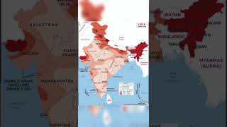
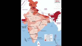
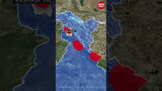
Can we visualize these zones on a map?
Definitely! Seismic zoning maps visually depict the various zones across India, showing where higher design considerations are needed.
In summary, seismic zoning maps are critical for informed decision-making in structural design, enhancing safety during earthquakes.
Introduction & Overview
Read summaries of the section's main ideas at different levels of detail.
Quick Overview
Standard
India's seismic zoning is critical for effective earthquake-resistant design, dividing the country into four distinct zones based on the severity of seismic risk. Each zone has a specific zone factor that affects building codes and engineering practices to ensure safety during earthquakes.
Detailed
The seismic zones of India are categorized into four levels: II, III, IV, and V, with Zone II representing areas of the least seismic threat and Zone V those with the highest risk. Removed from the classification structure is Zone I, as stated in IS 1893:2002. Each zone is assigned a zone factor (Z) that denotes the peak ground acceleration (PGA) expected during a Maximum Considered Earthquake (MCE). The respective zone factors as defined in IS 1893 (Part 1) are 0.10 for Zone II, 0.16 for Zone III, 0.24 for Zone IV, and 0.36 for Zone V. This zoning framework is essential for guiding engineers in designing buildings capable of adequately resisting seismic forces and ensuring public safety.
Youtube Videos


Audio Book
Dive deep into the subject with an immersive audiobook experience.
Seismic Zones in India
Chapter 1 of 2
🔒 Unlock Audio Chapter
Sign up and enroll to access the full audio experience
Chapter Content
India is divided into four seismic zones: II, III, IV, and V (Zone I was removed in IS 1893:2002).
Zone II: Least severe; Zone V: Most severe.
Detailed Explanation
India's seismic zones categorize the regions based on their vulnerability to earthquakes. The zones range from II to V, where Zone II indicates the least risk of seismic activity and Zone V indicates the highest risk. This classification helps engineers and builders understand the level of seismic threat in different parts of the country and design structures accordingly. For instance, buildings in Zone V must be constructed to withstand much stronger earthquakes compared to those in Zone II.
Examples & Analogies
Think of seismic zoning like weather forecasts in different regions. Just as you might prepare for a hurricane in a coastal area (which is more likely to face severe storms) differently than you would in a region with stable, calm weather, engineers design buildings differently depending on the seismic zone. A skyscraper in a Zone V city like Delhi will need to be built much stronger and more resilient than a house in a Zone II area, like parts of central India, which faces less seismic threat.
Zone Factor (Z)
Chapter 2 of 2
🔒 Unlock Audio Chapter
Sign up and enroll to access the full audio experience
Chapter Content
Represents the peak ground acceleration (PGA) for MCE.
Values in IS 1893 (Part 1):
- Zone II: Z = 0.10
- Zone III: Z = 0.16
- Zone IV: Z = 0.24
- Zone V: Z = 0.36
Detailed Explanation
The Zone Factor (Z) quantifies the level of seismic hazard specific to each zone by indicating the peak ground acceleration (PGA) for the Maximum Considered Earthquake (MCE). Higher Z values imply that structures in those zones need to be designed to withstand greater forces during seismic activities. For example, a building in Zone V (Z=0.36) is expected to endure much more intense shaking than a building in Zone II (Z=0.10). This factor is crucial for architects and civil engineers when they design new buildings or retrofit existing ones.
Examples & Analogies
Imagine you are designing a bridge over a river. If you know that the river has a high chance of flooding, you choose stronger materials and a higher foundation. Similarly, in earthquake-prone areas, the Zone Factor indicates how much stronger a building needs to be depending on the seismic risk. A higher Zone Factor can be likened to a more robust bridge design needed to cope with higher water levels during a flood, ensuring it stays intact and safe.
Key Concepts
-
Seismic Zones: Areas categorized into four zones based on seismic risk.
-
Zone Factor (Z): A crucial factor representing the peak ground acceleration for design.
-
Maximum Considered Earthquake (MCE): The severe ground shaking expected for a site.
Examples & Applications
Structures in Zone II can withstand less shaking compared to structures in Zone V, which need to be more robust against earthquakes.
A new building in an area classified as Zone IV must use a zone factor of 0.24 for its structural design.
Memory Aids
Interactive tools to help you remember key concepts
Rhymes
Two’s the least, four’s the more; V shakes heavy, II is a bore.
Stories
Imagine an engineer designing two buildings. One in Zone II, a light structure; the other in Zone V, a fortress bracing against the earthquake’s roar!
Memory Tools
Remember 'ZIV' for Zones In India, with V the strongest and II the softest.
Acronyms
ZONES
for Zones
for Order of risk
for Necessity of design
for Earthquake preparedness
for Safety.
Flash Cards
Glossary
- Seismic Zoning
Classification of areas based on their seismic risk to inform construction practices.
- Zone Factor (Z)
A numerical value representing the peak ground acceleration for Maximum Considered Earthquake.
- Maximum Considered Earthquake (MCE)
The most severe ground motion expected at a specific site.
- IS 1893
The Indian Standard code that provides guidelines for seismic design.
Reference links
Supplementary resources to enhance your learning experience.