
Applications of Actual Evapotranspiration Data
Enroll to start learning
You’ve not yet enrolled in this course. Please enroll for free to listen to audio lessons, classroom podcasts and take practice test.
Interactive Audio Lesson
Listen to a student-teacher conversation explaining the topic in a relatable way.
Irrigation Water Management
🔒 Unlock Audio Lesson
Sign up and enroll to listen to this audio lesson

Today we're discussing how AET, or actual evapotranspiration, assists in irrigation water management. Can anyone tell me why understanding AET is important in agriculture?

I think it helps us know how much water crops actually need.
Exactly! By estimating crop water requirements, farmers can schedule irrigation more effectively. This leads to better water usage and crop yield. Remember: AET helps to avoid over- or under-watering. Let's break this down a bit more. Can someone explain what might happen if a crop receives too much water?

It could lead to waterlogging and root rot.
Great point! And on the other hand, too little water could cause drought stress. AET gives us a balance.

How do we actually calculate how much AET we need for crops?
We often use soil moisture data in combination with AET measurements. For instance, integrating changes in soil moisture over time with precipitation data helps us estimate the exact needs. Anyone can guess why accurate calculations matter?

It could save water and improve efficiency.
Exactly! Efficient irrigation means lower costs and better sustainability. In summary, AET is essential for effective irrigation management to ensure crop health and resource efficiency.
Hydrologic Modelling
🔒 Unlock Audio Lesson
Sign up and enroll to listen to this audio lesson

Now, let's dive into hydrologic modeling and see how AET fits in. Who can share what hydrologic modeling is?
It's the process to simulate how water moves through the environment.
Spot on! AET is crucial in these models because it informs water balance studies, which are used for predicting floods and assessing droughts. Can anyone think of how AET affects flood forecasting?
If we know AET, we can better understand how much water is available and how it might flow into rivers.
Exactly! By knowing how much water is evaporating and transpiring, we can predict how much is left for runoff into rivers, helping in flood preparedness. It's crucial for management. Can anyone mention how this relates to drought assessment?
Understanding AET helps us figure out when water is getting low and how to manage it!
Very true! Knowing AET helps water managers understand when to take action in response to drought conditions. The main takeaway is that accurate AET data lead to more effective hydrologic models, which can save lives and resources.
Climate Change Studies
🔒 Unlock Audio Lesson
Sign up and enroll to listen to this audio lesson
Next, we will focus on the importance of AET in climate change studies. Why do we think monitoring AET is critical in this context?
Because climate change can change how much water evaporates from plants and soil?
Exactly! As global temperatures rise, we may see shifts in AET patterns. This monitoring helps researchers understand how climate change impacts water cycles. Can anyone give examples of such impacts?
Increased temperatures may lead to higher evaporation rates?
Correct! This could mean less water is available for crops and ecosystems. Regular monitoring allows scientists to adapt water management practices to changing climatic conditions. Remembering well: AET is a window into understanding our changing environment!
Groundwater Recharge Analysis
🔒 Unlock Audio Lesson
Sign up and enroll to listen to this audio lesson
Let’s discuss how AET assists in groundwater recharge analysis. Can anyone define groundwater recharge?
It's the process of water seeping into the ground to replenish aquifers.
Excellent! AET helps us estimate how much water is available for recharge. Why does this information matter?
Because it helps manage our water resources sustainably!
Absolutely! By knowing AET, water managers can evaluate percolation rates and make informed decisions about water usage and conservation. What could happen if we over-allocate water without considering AET?
We could deplete our aquifers and face water scarcity!
Right! Sustainable management is key, and AET data supports it. Another aspect is how AET varies across different regions. How might that affect groundwater recharge?
Different climates and land use will affect how much water gets absorbed.
Exactly! Understanding these dynamics is vital. To summarize, AET aids in analyzing groundwater recharge potential, promoting sustainable water practices.
Catchment Management
🔒 Unlock Audio Lesson
Sign up and enroll to listen to this audio lesson
Finally, let's look at how AET relates to catchment management. What do we mean by catchment management?
It's planning how to use land and water resources in a specific area.
Exactly! AET data provides crucial insights for catchment management. Can anyone guess how AET can guide land use planning?
By determining when and where to allocate water for crops or conservation?
Absolutely right! By factoring in AET, planners can make informed decisions on sustainable practices. Why do you think this is particularly important?
It prevents issues like overdevelopment and water shortages.
Great observation! Managing water efficiently is key to ecological health. As a recap, AET data supports informed decision-making in catchment management for sustainable land and water use.
Introduction & Overview
Read summaries of the section's main ideas at different levels of detail.
Quick Overview
Standard
Actual evapotranspiration data have numerous practical applications including irrigation management, hydrologic modeling, climate change studies, groundwater analysis, and catchment management. Understanding these applications is crucial for effective water resource management.
Detailed
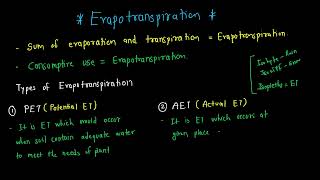
Applications of Actual Evapotranspiration Data
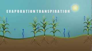
Actual evapotranspiration (AET) data play a critical role in hydrology and environmental management by providing insights into several key areas:
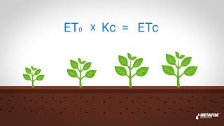
- Irrigation Water Management: AET data is essential for estimating crop water requirements, helping farmers and agricultural managers optimize irrigation schedules. This leads to efficient water usage and improved crop yield.
- Hydrologic Modelling: AET contributes to accurate water balance studies that are vital for flood forecasting and drought assessment. By understanding AET, hydrologists can better predict water availability and manage water resources effectively.
- Climate Change Studies: Monitoring AET allows scientists to observe changes in evapotranspiration patterns associated with global warming, making it a valuable tool for climate change research.
- Groundwater Recharge Analysis: AET data aid in estimating percolation rates and the potential for groundwater recharge. This information is crucial for sustainable water management practices.
- Catchment Management: AET data supports sustainable planning and decision-making in land and water use within a basin, helping to balance ecological needs with human activities.
In summary, the applications of AET are multiple and impactful, informing sustainable practices in both agriculture and environmental stewardship.
Youtube Videos


Audio Book
Dive deep into the subject with an immersive audiobook experience.
Irrigation Water Management
Chapter 1 of 5
🔒 Unlock Audio Chapter
Sign up and enroll to access the full audio experience
Chapter Content
Estimating crop water requirements and scheduling irrigation.
Detailed Explanation
Irrigation water management revolves around understanding how much water crops need. Actual evapotranspiration (AET) data is crucial for estimating these requirements. By knowing the amount of water that plants lose through evapotranspiration, farmers can determine how much additional water needs to be supplied through irrigation. This helps in scheduling irrigation to match the crop’s needs, thereby optimizing water use.
Examples & Analogies
Imagine a student preparing for exams who knows they need to study for a certain number of hours each subject. They allocate time weekly for each subject based on how much content they need to cover. Similarly, farmers use AET data to allocate irrigation hours based on how much water the plants need.
Hydrologic Modelling
Chapter 2 of 5
🔒 Unlock Audio Chapter
Sign up and enroll to access the full audio experience
Chapter Content
Water balance studies, flood forecasting, and drought assessment.
Detailed Explanation
AET data is integral to hydrologic modeling, helping to simulate and understand the movement of water within the ecosystem. By analyzing AET, hydrologists can perform water balance studies to evaluate how much water is available, predict floods by understanding rainfall and evaporation relationships, and assess drought conditions by determining how much water is being lost through AET. These models rely on accurate AET data to make reliable predictions.
Examples & Analogies
Think of hydrologic modeling like a budget for a household. Just as a family tracks their income and expenses to predict how much money they’ll have in the future, hydrologists use AET data to track water inputs (like rainfall) and outputs (like evaporation) to manage our water resources effectively.
Climate Change Studies
Chapter 3 of 5
🔒 Unlock Audio Chapter
Sign up and enroll to access the full audio experience
Chapter Content
Monitoring changes in ET patterns due to global warming.
Detailed Explanation
AET plays a critical role in climate change studies by helping scientists monitor changes in evapotranspiration patterns. As global temperatures rise, the rates of evaporation may change, affecting local climates and ecosystems. By analyzing AET over time, researchers can understand how climate change is altering these patterns and its implications on water resources and agriculture.
Examples & Analogies
Consider a garden that receives different sunlight and temperatures as seasons change. If the climate gets warmer, the plants may lose more water, just as AET might increase with rising global temperatures. Monitoring this can help gardeners decide which plants may thrive or struggle in these new conditions.
Groundwater Recharge Analysis
Chapter 4 of 5
🔒 Unlock Audio Chapter
Sign up and enroll to access the full audio experience
Chapter Content
Estimating percolation and recharge potential.
Detailed Explanation
AET data is vital for analyzing groundwater recharge, which is the process of water infiltrating from the surface into underground aquifers. By determining how much water is lost to the atmosphere through AET, scientists can estimate how much water can potentially recharge the groundwater. This information is essential for sustainable water management and ensuring that aquifers remain viable for future use.
Examples & Analogies
Think of groundwater recharge like a sponge absorbing water. If a sponge (soil) loses water quickly through evaporation (AET), it will take longer for it to get fully soaked again. Understanding AET helps uncover how much water is available for the sponge to soak up.
Catchment Management
Chapter 5 of 5
🔒 Unlock Audio Chapter
Sign up and enroll to access the full audio experience
Chapter Content
Sustainable planning of land and water use in a basin.
Detailed Explanation
Effective catchment management requires understanding how water moves through an ecosystem. AET data facilitates sustainable planning of land and water use within a basin by identifying areas where water loss is significant. This ensures that land use practices account for AET effects, promoting sustainable agriculture, protecting water resources, and minimizing adverse environmental impacts.
Examples & Analogies
Imagine a community planning a festival on a large piece of land. They need to know how much water flowers will need to stay vibrant and not wilt. Similarly, catchment management uses AET to understand how much water various parts of the land will require to remain healthy and productive.
Key Concepts
-
Irrigation Water Management: The process of optimizing water application in agriculture using AET data.
-
Hydrologic Modeling: The simulation of water movement, heavily reliant on understanding AET for flood and drought predictions.
-
Climate Change Studies: Monitoring AET to observe patterns of change in evapotranspiration due to global warming.
-
Groundwater Recharge: Utilizing AET to analyze and improve groundwater replenishment strategies.
-
Catchment Management: The importance of AET data for effective land and water resource planning.
Examples & Applications
Farmers using AET data to schedule irrigation and improve water conservation.
Hydrologists incorporating AET into models to predict flood risks and manage water resources effectively.
Researchers analyzing AET patterns to assess the impact of rising temperatures on water availability.
Memory Aids
Interactive tools to help you remember key concepts
Rhymes
AET, oh can't you see, saves crops from drought so easily!
Stories
Once upon a time, in a land where the crops ran dry, AET came to the rescue by telling farmers when to rehydrate their fields, leading to a bountiful harvest.
Memory Tools
AET = Agriculture Evaporation Timing - helps farmers get their timing right.
Acronyms
AET = Actual Evapotranspiration
Always Evaluate Timing for water management.
Flash Cards
Glossary
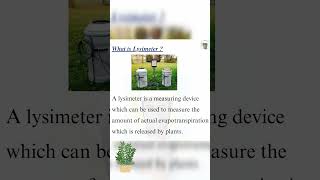
- Actual Evapotranspiration (AET)
The total quantity of water removed from the soil-plant system due to evaporation and transpiration under current environmental conditions.
- Irrigation Water Management
The practice of managing the timing and amount of water applied to agricultural crops to optimize yield and minimize waste.
- Hydrologic Modeling
The use of mathematical models to represent and simulate the movement and distribution of water in the environment.
- Groundwater Recharge
The process by which water seeps into the ground to replenish aquifers.
- Catchment Management
The systematic and sustainable management of land and water resources in a specific area or drainage basin.
Reference links
Supplementary resources to enhance your learning experience.