
Estimation Methods of Actual Evapotranspiration
Enroll to start learning
You’ve not yet enrolled in this course. Please enroll for free to listen to audio lessons, classroom podcasts and take practice test.
Interactive Audio Lesson
Listen to a student-teacher conversation explaining the topic in a relatable way.
Soil Water Balance Method
🔒 Unlock Audio Lesson
Sign up and enroll to listen to this audio lesson

Today, we're going to discuss the Soil Water Balance Method. This method estimates AET by looking at the changes in soil moisture using the equation AET = P - R - D - ΔS, where P is precipitation.

Could you please explain the other components of the equation?
Sure! R is runoff, which is the water that flows over soil rather than infiltrating. D stands for deep percolation, which is water that moves past the root zone. Finally, ΔS is the change in soil moisture storage.

Why is this method useful in agriculture?
Great question! It's useful because it helps determine how much water is actually available for crops and whether irrigation is needed. Remember, accurate AET estimates support better water management!

So, does this method always have accurate data?
Not always. Accuracy depends on reliable soil moisture data. If that data is off, so is the AET estimate. Always consider the context!

Can you summarize the key points?
Certainly! The Soil Water Balance Method is based on a simple equation that requires accurate inputs for a precise AET estimation. It's vital for managing water in agricultural contexts.
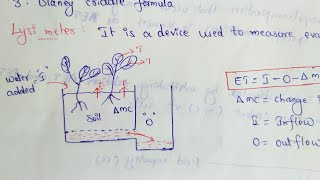
Lysimeter Method
🔒 Unlock Audio Lesson
Sign up and enroll to listen to this audio lesson

Now, let's talk about the Lysimeter Method. This involves measuring AET directly by weighing a column of soil over time.
What's the difference between weighing and non-weighing lysimeters?
Good question! Weighing lysimeters can measure changes in weight continuously, while non-weighing lysimeters need manual observation. Both are accurate but differ in their operational ease.
Are there any drawbacks to using lysimeters?
Yes, they can be expensive, and their effectiveness often varies based on location. They also require careful installation and management.
I see! How does it compare to other methods?
It's very accurate compared to estimations like the Soil Water Balance Method, but it has limited spatial coverage and can be resource-intensive.
So, lysimeters are suitable for experimental studies, then?
Exactly! They're ideal for research scenarios where high precision is needed.
Remote Sensing Methods
🔒 Unlock Audio Lesson
Sign up and enroll to listen to this audio lesson
Next, let's discuss Remote Sensing methods. These utilize satellite data to estimate AET across large areas.
What specific satellite data is used?
Good question! A commonly used metric is the NDVI, which helps monitor vegetation health and density.
How do algorithms like SEBAL work for AET estimation?
SEBAL uses surface energy balance principles to estimate the available energy at the surface. This is then correlated with AET by considering vegetation types.
What are the benefits of using Remote Sensing?
Some key benefits include large spatial coverage, making it invaluable for regional water resource management, especially in areas where ground data is scarce.
Are there any limitations?
Yes, while they provide broad coverage, the accuracy can be limited by factors like cloud cover or coarse spatial resolution.
Can you summarize this session?
Absolutely! Remote Sensing allows for comprehensive AET estimation using satellite data, crucial for water management, despite some inherent limitations.
Introduction & Overview
Read summaries of the section's main ideas at different levels of detail.
Quick Overview
Standard
AET estimation is vital for efficient water resource management and agricultural practices. This section covers several estimation methods that provide insights into how to calculate AET, including the Soil Water Balance method, Lysimeter method, Remote Sensing techniques, and the use of empirical formulas and micrometeorological methods, highlighting their advantages and limitations.
Detailed
Estimation Methods of Actual Evapotranspiration
Overview
The section outlines several methods to estimate Actual Evapotranspiration (AET), which is crucial for various applications in hydrology, agriculture, and environmental management. Accurate estimation of AET is essential for understanding water balance in different scenarios, including irrigation management, groundwater recharge, and climate studies.
Types of Estimation Methods
1. Soil Water Balance Method
- This method uses the water balance equation:
AET = P - R - D - ΔS
where P is precipitation, R is runoff, D is deep percolation, and ΔS is change in soil moisture storage. This method is effective when reliable soil moisture data are available.
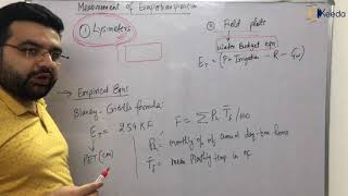
2. Lysimeter Method
- Lysimeters directly measure evapotranspiration by tracking the weight of a soil column. They can be either weighing or non-weighing types and are known for their accuracy, though they are also expensive and location-specific.
3. Remote Sensing Methods
- Utilizing satellite data, methods such as NDVI (Normalized Difference Vegetation Index) and algorithms like SEBAL (Surface Energy Balance Algorithm for Land) help in estimating AET over large areas. These methods are advantageous for regional management, offering large spatial coverage.
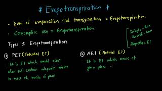
4. Empirical Formulas and Crop Coefficients
- The FAO Penman-Monteith equation estimates Potential Evapotranspiration (PET), which is then adjusted using crop coefficients to derive AET. These coefficients account for vegetation type and growth stage.
5. Eddy Covariance and Bowen Ratio Methods
- These micrometeorological techniques measure turbulent fluxes of latent heat to estimate AET. They are particularly suited for research contexts where precision is critical.
Conclusion
Each method carries its own advantages, limitations, and contexts for appropriate application, providing crucial tools for hydrologists and water resource managers.
Youtube Videos


Audio Book
Dive deep into the subject with an immersive audiobook experience.
Soil Water Balance Method
Chapter 1 of 5
🔒 Unlock Audio Chapter
Sign up and enroll to access the full audio experience
Chapter Content
This method estimates AET by computing the change in soil moisture over time using the water balance equation:
AET=P−R−D−ΔS
Where:
- P: Precipitation
- R: Runoff
- D: Deep percolation
- ΔS: Change in soil moisture storage
This method is widely used in watershed hydrology and agriculture, especially when reliable soil moisture data are available.
Detailed Explanation
The Soil Water Balance Method calculates Actual Evapotranspiration (AET) by considering the inputs and outputs of water in the soil system. It uses the water balance equation: AET = P - R - D - ΔS. Here, 'P' represents precipitation, which is the water added to the soil. 'R' is runoff, which is water that flows away from the area instead of infiltrating into the soil. 'D' stands for deep percolation, where water moves below the root zone beyond the reach of plant roots. Finally, 'ΔS' indicates the change in soil moisture storage, which accounts for how much water is retained or absorbed by the soil over a period. Reliable soil moisture data are crucial for accurate estimations using this method, emphasizing its importance in agricultural and watershed applications.
Examples & Analogies
Imagine a sponge soaking up water (precipitation) after a rainstorm. Some water leaks out (runoff), while some water drips out from the bottom (deep percolation). The amount of water retained in the sponge (change in soil moisture storage) is ultimately what the sponge can provide to a plant. By keeping track of these factors, farmers can understand how much water is actually available for crops to use.
Lysimeter Method
Chapter 2 of 5
🔒 Unlock Audio Chapter
Sign up and enroll to access the full audio experience
Chapter Content
• Lysimeters are precision devices that simulate field conditions and directly measure evapotranspiration by recording the change in weight of a soil column.
• Two types: Weighing and Non-weighing lysimeters.
• Accurate but expensive and location-specific.
Detailed Explanation
The Lysimeter Method involves the use of specially designed devices called lysimeters, which help measure evapotranspiration directly. These devices simulate real-world soil conditions by containing a specific volume of soil. By measuring changes in the weight of the soil column over time, researchers can calculate how much water has evaporated and transpired. There are two types: weighing lysimeters, which continuously measure the weight of the soil to capture changes, and non-weighing lysimeters, which may require other methods to ascertain changes in moisture. While highly accurate, lysimeters can be costly to install and are typically used in specific locations depending on the research needs.
Examples & Analogies
Think of a lysimeter like a very sophisticated scale for a plant's garden. Just as a kitchen scale tells you how much weight you’re putting in a bowl, a lysimeter tells scientists how much water is evaporating from the soil around the plant. This helps them get precise measurements to understand water use, but the high cost means they can't just set one up everywhere; instead, they’ll pick the best spots, much like high-end kitchens only use precise scale for special recipes.
Remote Sensing and Satellite-Based Methods
Chapter 3 of 5
🔒 Unlock Audio Chapter
Sign up and enroll to access the full audio experience
Chapter Content
• Use NDVI (Normalized Difference Vegetation Index) and surface temperature data from satellites.
• Algorithms such as SEBAL (Surface Energy Balance Algorithm for Land) or METRIC (Mapping EvapoTranspiration at high Resolution with Internalized Calibration) are applied.
Advantages:
- Large spatial coverage
- Useful for regional water resource management
Detailed Explanation
Remote Sensing and Satellite-Based Methods employ technology to measure evapotranspiration from above the Earth’s surface. By using satellite data like the NDVI, which helps estimate vegetation health and cover, and surface temperature data, these methods can analyze large areas without needing ground-based measurements. Algorithms such as SEBAL and METRIC further process this data to provide estimations of AET. The major advantages of these methods include their ability to cover extensive areas quickly and their importance in managing water resources at a regional scale, helping planners understand where water is most needed.
Examples & Analogies
Imagine using a drone equipped with a camera to survey a large field instead of walking it on foot. Just like that drone can quickly capture a much wider view of the field’s health, satellite methods allow scientists to monitor water use across vast landscapes. This is especially important in managing water for farming in different areas, helping ensure that crops get the right amount without wasting precious resources.
Empirical Formulas and Crop Coefficients
Chapter 4 of 5
🔒 Unlock Audio Chapter
Sign up and enroll to access the full audio experience
Chapter Content
• FAO Penman-Monteith equation is used to estimate PET, which is then multiplied by a crop coefficient (Kc) to estimate AET:
AET=Kc × PET
• The crop coefficient accounts for the type, stage, and density of vegetation.
Detailed Explanation
Estimating Actual Evapotranspiration (AET) can also be done using empirical formulas along with crop coefficients. The FAO Penman-Monteith equation calculates Potential Evapotranspiration (PET), which indicates the maximum ET under ideal conditions. To find the actual amount of ET, this PET value is multiplied by a crop coefficient (Kc), which adjusts the estimate based on the specific type of plant, its growth stage, and how dense the vegetation is. The crop coefficient ensures that variations in plant behavior and local climate conditions are taken into account.
Examples & Analogies
Consider watering a plant at different stages of its growth. A young seedling needs less water than a fully-grown plant because it’s smaller and less thirsty. By using the crop coefficient like a scaling factor, we adjust our water estimates according to what the plant needs at its current stage in order to thrive.
Eddy Covariance and Bowen Ratio Method
Chapter 5 of 5
🔒 Unlock Audio Chapter
Sign up and enroll to access the full audio experience
Chapter Content
• These are micrometeorological methods that use turbulent fluxes of latent heat to determine evapotranspiration.
• Suitable for research and high-precision studies.
Detailed Explanation
The Eddy Covariance and Bowen Ratio Methods are advanced micrometeorological techniques used to measure evapotranspiration with high accuracy. The Eddy Covariance method involves capturing the movement of air and its heat content above a plant canopy to estimate how much water vapor is being lost. Meanwhile, the Bowen Ratio method analyzes the relationship between sensible heat (temperature) and latent heat (evaporation) to derive evapotranspiration rates. These methods are often used in research settings where precision is critical, allowing scientists to gather detailed insights into the environmental processes at play.
Examples & Analogies
Think of these methods like a superhero with a special power to feel the air around them. Just like a superhero can sense changes in their environment, scientists use tools to accurately 'feel' how much water is evaporating from plants and soil, helping them understand the nuances of water use in the ecosystem.
Key Concepts
-
Soil Water Balance Method: An equation-based estimation technique considering precipitation, runoff, deep percolation, and soil moisture.
-
Lysimeter: A device for precise measurement of evapotranspiration by simulating field conditions.
-
Remote Sensing: An approach that utilizes satellite data to estimate AET over large spatial areas.
Examples & Applications
Using the Soil Water Balance Method, farmers can determine when to irrigate crops by analyzing precipitation and soil moisture data.
Lysimeters help researchers accurately measure how much water is lost to transpiration in different soil types.
Memory Aids
Interactive tools to help you remember key concepts
Rhymes
For AET that’s truly key, it’s moisture loss from soil and tree.
Stories
Imagine a farmer, watching the rain while measuring his field with special tools. He uses weight to see what’s lost to the sun and what his crops must gain.
Memory Tools
Remember 'PRDS' for Soil Water Balance - Precipitation, Runoff, Deep percolation, Soil moisture change.
Acronyms
Lysimeter
'Lysimeter' stands for 'Lively yield sensor measuring ground evaporation.'
Flash Cards
Glossary
- Actual Evapotranspiration (AET)
The quantity of water removed from the soil-plant system due to evaporation and transpiration under specific conditions.
- Soil Water Balance Method
An estimation approach that calculates AET by balancing inputs and outputs of water in the soil.
- Lysimeter
A device that measures the amount of water lost through evapotranspiration by weighing a soil column.
- NDVI
Normalized Difference Vegetation Index; a metric derived from satellite data used to assess vegetation health.
- SEBAL
Surface Energy Balance Algorithm for Land; a method using satellite data to estimate AET based on energy balance.
Reference links
Supplementary resources to enhance your learning experience.