
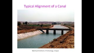
Alignment of Canals
Enroll to start learning
You’ve not yet enrolled in this course. Please enroll for free to listen to audio lessons, classroom podcasts and take practice test.
Interactive Audio Lesson
Listen to a student-teacher conversation explaining the topic in a relatable way.
Understanding Canal Alignment
🔒 Unlock Audio Lesson
Sign up and enroll to listen to this audio lesson

Today, we will discuss canal alignment. Can anyone tell me why the alignment of a canal is so important?

I think it's important because it helps with water flow!
Exactly! Proper alignment significantly influences the efficiency and the amount of water that reaches its destination. What other factors do you think might affect alignment?

Maybe the shape of the land? Like hills or valleys?
Precisely! Topography plays a crucial role. We need to follow natural contours to minimize costs and optimize water flow. Let's remember: Topography, Soil, Cross-drainage, Command Area, and Economy—these are our *T-SCC-E* points. Can anyone explain how soil conditions could affect canal alignment?

If the soil is too wet or sandy, it might not hold the water well, right?
Yes! Waterlogged soils can lead to seepage losses; hence, we avoid such areas for canal construction. In summary, efficient canal alignment considers topographical shapes and soil conditions—critical for reducing losses and costs.
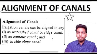
Types of Canal Alignment
🔒 Unlock Audio Lesson
Sign up and enroll to listen to this audio lesson

Now that we've established how important alignment is, let’s look into the types of canal alignments. Can anyone name a type we discussed?

Contour canals! They follow the land’s shape.
Correct! And what is the advantage of using a contour canal?
It minimizes erosion and maintains water flow over the landscape.
Exactly! Now, what about ridge canals? Who can tell me how they work?
Ridge canals run along the top of hills, right? They can supply water to both sides.
Very well! Ridge canals are indeed beneficial because they allow water distribution efficiently. Remembering the types of canals is essential, as each serves a unique purpose based on geography. For additional context, side slope and valley canals require different management strategies due to their designs.
Significance of Proper Canal Alignment
🔒 Unlock Audio Lesson
Sign up and enroll to listen to this audio lesson
Let’s talk about why proper canal alignment matters in real-world applications. Why do you think misalignment could be costly?
If the canal isn’t aligned properly, it might lead to more losses due to seepage or evaporation.
Exactly! Misalignment can reduce efficiency. Additionally, miscalculating the required materials can escalate costs. What kind of strategies can be implemented to ensure effective alignment?
We could use surveys and mapping technology to assess the land beforehand.
That’s a robust approach! Proper planning and technology can lead to significant savings both economically and in terms of water management. Let’s remember our earlier acronym *T-SCC-E*. These points guide us in maintaining economies of scale and environmental considerations.
Introduction & Overview
Read summaries of the section's main ideas at different levels of detail.
Quick Overview
Standard
This section delves into the principles and types of canal alignment, emphasizing factors such as topography, soil conditions, and the economic considerations that dictate the design of canal pathways. Proper alignment not only reduces construction costs but also enhances irrigation coverage.
Detailed
Principles of Canal Alignment
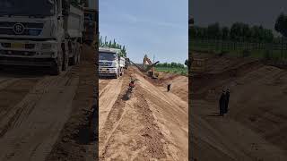
The alignment of canals is a crucial aspect of their design, ensuring they function efficiently while minimizing losses. The key factors influencing canal alignment include topography, where canals should follow natural contours to reduce earthwork; soil conditions, where waterlogged or highly permeable areas should be avoided; the need to minimize cross-drainage works such as aqueducts and siphons; command area coverage to maximize irrigation; and economic efficiency in material and labor usage.
Types of Canal Alignment
There are four main types of canal alignment:
1. Contour Canal: Aligned along contour lines, ideal for undulating terrains.
2. Ridge Canal: This runs along the watershed and can supply water to both sides.
3. Side Slope Canal: Constructed along the slope of a valley or hill.
4. Valley Canal: Aligned through a valley, often requiring additional cross-drainage works.
The alignment process ensures that canals can achieve their intended purposes—whether for irrigation, irrigation coverage, or minimizing water losses—resulting in a more effective management of water resources.
Youtube Videos


Audio Book
Dive deep into the subject with an immersive audiobook experience.
Principles of Canal Alignment
Chapter 1 of 2
🔒 Unlock Audio Chapter
Sign up and enroll to access the full audio experience
Chapter Content
Proper alignment is critical for efficient operation and minimal losses. Factors influencing alignment:
- Topography: Canals should follow natural contours to minimize earthwork.
- Soil Conditions: Avoid water-logged or highly permeable soils.
- Cross-drainage Works: Minimize the number and size of CD works like aqueducts and siphons.
- Command Area: The alignment must ensure irrigation coverage for the maximum possible area.
- Economy: Optimum use of materials and labor with the least construction cost.
Detailed Explanation
This chunk outlines the various principles that govern the alignment of canals. Each principle is crucial for ensuring that the canal functions effectively and cost-efficiently.
- Topography refers to the physical features of the land. Following the natural contours means less digging and moving earth, which saves money and labor.
- Soil Conditions indicate that certain types of soil may absorb water too quickly or hold too much water, which can affect how a canal is built.
- Cross-drainage Works (CD works) are structures that help manage the water flow in the canal. Minimizing these helps reduce construction and maintenance costs.
- The Command Area principle emphasizes the goal of irrigating as much land as possible.
- Lastly, Economy involves using resources wisely to keep construction costs low, which is essential for the viability of any canal project.
Examples & Analogies
Think of building a canal like creating a road. A well-designed road follows the natural landscape to avoid unnecessary hills and valleys, which saves on construction costs. Similarly, by designing a canal that follows the land's contours, engineers save on materials and can provide better irrigation to more farmland.
Types of Canal Alignment
Chapter 2 of 2
🔒 Unlock Audio Chapter
Sign up and enroll to access the full audio experience
Chapter Content
- Contour Canal: Aligned along the contour line; best for undulating terrain.
- Ridge Canal: Runs along the watershed; supplies water to both sides.
- Side Slope Canal: Constructed along the slope of a valley or hill.
- Valley Canal: Aligned through the valley, often requiring CD works.
Detailed Explanation
This chunk introduces the types of canal alignments, each suited to specific geographical features:
- A Contour Canal is built along the contour lines of the land, making it ideal for areas that are not flat. This helps to reduce soil erosion and maintain water levels.
- A Ridge Canal is placed on high land, allowing water to flow down to both sides, which is useful for irrigating a larger area.
- Side Slope Canals are built on the side of a slope, which can take advantage of gravity to help move water.
- A Valley Canal runs through a low area and may need special structures (CD works) to manage water flow effectively.
Examples & Analogies
Imagine walking along a mountain trail. A contour path would follow the mountain's curves, keeping a steady, gentle slope. In the same way, a contour canal follows the land's natural shape, making it efficient for transporting water without excessive digging.
Key Concepts
-
Topography: The natural features of the land, crucial for directing water flow.
-
Canal Types: Different alignments serve specific purposes depending on geography.
-
Cross-drainage Works: Necessary constructions to maintain water flow across terrains.
-
Seepage Losses: Loss of water that can greatly affect the efficiency of canal systems.
Examples & Applications
A contour canal maintaining consistent irrigation on sloped terrain.
A valley canal that needs aqueducts for water flow over rivers.
Memory Aids
Interactive tools to help you remember key concepts
Rhymes
Canal alignment's all about, Topography, soil, and no doubt.
Stories
Imagine building a canal like a snake slithering over hills and valleys, curving gracefully to follow the land. It's how nature guides us to efficiently carry water!
Memory Tools
Remember T-SCC-E: Topography, Soil, Cross-drainage, Command Area, Economy for efficient canals.
Acronyms
Use *TEC*
Topography
Economy
and Command area for planning efficient canal alignment.
Flash Cards
Glossary
- Canal Alignment
The positioning and shape of a canal as it runs through terrain, influenced by various geographical and hydrological factors.
- Topography
The arrangement of the natural features of an area, affecting water flow and canal design.
- Crossdrainage Works
Structures like aqueducts and siphons that manage the flow of water across canals.
- Seepage Losses
Water loss occurring when the water seeps into the ground through the canal bed and banks.
Reference links
Supplementary resources to enhance your learning experience.