
Aerial Surveying and Mapping
Enroll to start learning
You’ve not yet enrolled in this course. Please enroll for free to listen to audio lessons, classroom podcasts and take practice test.
Interactive Audio Lesson
Listen to a student-teacher conversation explaining the topic in a relatable way.
Overview of Aerial Surveying
🔒 Unlock Audio Lesson
Sign up and enroll to listen to this audio lesson

Aerial surveying is defined as capturing images and data from an elevated position using UAVs or drones. What do you think could be the benefits of using this technology?

Is it faster than traditional surveying methods?
Absolutely! One of its biggest advantages is rapid data collection. Can anyone guess another benefit?

I think it’s safer since you don't have to physically go to dangerous places.
Correct! Aerial surveying enhances safety in inaccessible areas. Let's remember these points with the acronym 'RHS-C' for Rapid, High-resolution, Safety, Cost-effective.

What about accuracy?
A great question! The use of Ground Control Points significantly improves accuracy, and we'll explore that next.
Types of UAVs in Aerial Surveying
🔒 Unlock Audio Lesson
Sign up and enroll to listen to this audio lesson

Now, let’s talk about the different types of UAVs. We have fixed-wing drones, multi-rotor drones, and hybrid drones. Who can tell me about fixed-wing drones?

Fixed-wing drones are good for long distances and large surveys, right?
Exactly! They’re efficient for covering extensive areas. How about multi-rotor drones?
They are easier to maneuver and better for small sites.
Correct, and while they have shorter flight times, they are very precise. Let's create a mnemonic to remember their characteristics: 'M-FH' where M = Multi-rotor, F = Fixed-wing, H = Hybrid.
So, hybrid drones must combine the benefits of both?
Yes, precisely! Each type of drone has its ideal application based on the survey context.
Data Acquisition Techniques
🔒 Unlock Audio Lesson
Sign up and enroll to listen to this audio lesson
Now, let’s discuss data acquisition techniques. What do you think is important about capturing images?
The images should be geotagged, right?
Exactly! Geotagging ensures that images are associated with their precise location. We prefer consistent lighting and low wind conditions for quality data collection.
What about when using LiDAR?
Great point! LiDAR systems collect thousands of points per second, including elevation data. Let's use the acronym 'GPD' for Geotagged images, Point clouds, and Data processing to remember these key data collection methods.
Applications in Civil Engineering
🔒 Unlock Audio Lesson
Sign up and enroll to listen to this audio lesson
Aerial surveying has numerous applications in civil engineering. Can someone name one application?
Topographical mapping for creating contour maps!
Correct! It's vital for planning and designing infrastructure. What’s another application?
Construction monitoring, to track site progress.
Yes! With aerial surveying, contractors get real-time insights, which leads to better planning. Remember the mnemonic 'TC-SR' for Topographical mapping, Construction monitoring, Safety inspections, and Real-time data.
Challenges and Future Trends
🔒 Unlock Audio Lesson
Sign up and enroll to listen to this audio lesson
Let's conclude by discussing challenges in aerial surveying. What challenges can you think of?
Weather conditions affect data quality, for instance.
Absolutely! Weather can be unpredictable. What about battery life?
Yes, limited battery and range restrict surveys!
Great insights! As for future trends, we’re seeing AI and real-time mapping gaining traction. Let’s remember 'WR-BAT' for Weather dependency, Regulatory issues, Battery limitations, and Automation in technology.
Introduction & Overview
Read summaries of the section's main ideas at different levels of detail.
Quick Overview
Standard
This section describes the technologies and techniques involved in aerial surveying and mapping, emphasizing UAVs and sensors that improve the accuracy, speed, and safety of civil engineering surveys. Key components, types of UAVs, and applications in various civil engineering contexts are discussed.
Detailed
Detailed Summary of Aerial Surveying and Mapping
Aerial surveying and mapping represent innovative advances in civil engineering, revolutionizing how data is collected across large areas using unmanned aerial vehicles (UAVs), drones, and advanced remote sensing technologies. This section delves into several critical aspects of aerial surveying:
- Overview of Aerial Surveying: Aerial surveying involves capturing elevated data, thus replacing traditional methods with rapid, high-resolution processes. Key components of this technology include drone platforms, GPS systems, high-resolution cameras or LiDAR sensors, Ground Control Points (GCPs), and sophisticated processing software.
- Types of UAVs: The section categorizes drones into fixed-wing, multi-rotor, and hybrid models, highlighting their appropriate uses based on survey requirements. Fixed-wing drones cover large expanses, multi-rotor drones excel in precision, especially in confined spaces, while hybrid drones combine capabilities of both types.
- Sensor Types: Various sensors are discussed, including RGB cameras for imagery, multispectral sensors for environmental monitoring, thermal cameras for heat mapping, and LiDAR systems for accurate 3D modeling. Each type plays a crucial role in different surveying applications.
- Survey Planning: Essential steps in survey planning include thorough site assessments considering terrain and weather conditions, followed by using mission planning software to set parameters for drone operations.
- Data Acquisition and Processing: Techniques for image capture and LiDAR data collection are introduced, alongside photogrammetric methods for creating 3D models from images. The importance of software in processing this data for accurate outputs is emphasized.
- Accuracy and Ground Control: To enhance accuracy, the use of GCPs, RTK, and PPK systems is explained. Ground control points improve georeferencing, while RTK and PPK drones provide high positional accuracy through advanced satellite systems.
- Applications and Challenges: The wide-ranging applications of aerial surveying are detailed, such as in topographical mapping and disaster management. Challenges such as weather dependency and regulatory constraints are also highlighted, framing the context within which aerial surveying operates.
- Future Trends: Innovations like AI-based automation and real-time mapping capabilities are discussed, suggesting that the field is continuously evolving to integrate more advanced technologies.
Through this section, students gain a holistic understanding of the aerial surveying landscape in civil engineering, grasping the significance of drones, sensors, data processing, and their applications in real-world scenarios.
Youtube Videos


Audio Book
Dive deep into the subject with an immersive audiobook experience.
Introduction to Aerial Surveying and Mapping
Chapter 1 of 12
🔒 Unlock Audio Chapter
Sign up and enroll to access the full audio experience
Chapter Content
Aerial surveying and mapping are revolutionary methods in the field of civil engineering that utilize unmanned aerial vehicles (UAVs), drones, and remote sensing technologies to capture high-resolution data over large geographic areas.
Detailed Explanation
Aerial surveying and mapping refer to the process of capturing detailed images and data from high above the ground, using technologies like drones and UAVs. These methods have transformed traditional civil engineering practices by allowing professionals to obtain precise measurements and imagery over large areas, which was previously time-consuming and labor-intensive.
Examples & Analogies
Imagine trying to get a detailed view of a sprawling park from the ground level—it's limiting. Now, think about flying a drone above the park, providing a bird's-eye view. This is akin to a scout who can provide crucial insights about an entire field, rather than just a small corner.
Advantages of Aerial Surveying
Chapter 2 of 12
🔒 Unlock Audio Chapter
Sign up and enroll to access the full audio experience
Chapter Content
Advantages over Traditional Surveying:
– Rapid data collection
– High-resolution imagery
– Enhanced safety in inaccessible areas
– Cost-effectiveness over large terrains
– Reduced manpower requirements
Detailed Explanation
Aerial surveying has several key advantages compared to traditional ground surveying methods. Data can be collected much faster, and the imagery captured is often of much higher resolution. Additionally, aerial surveying improves safety by allowing surveys in areas that are difficult or dangerous to access on foot. There's also an economic benefit, as it can be more cost-effective for covering extensive terrains and requires fewer workers compared to traditional methods.
Examples & Analogies
Consider the difference between sending a large team to survey a remote construction site on foot versus deploying a single drone to gather data. The drone can cover immense areas quickly and without the risks associated with traversing challenging landscapes.
Key Components of Aerial Surveying System
Chapter 3 of 12
🔒 Unlock Audio Chapter
Sign up and enroll to access the full audio experience
Chapter Content
Key Components of an Aerial Surveying System:
– Drone/UAV platform
– GPS and IMU systems
– High-resolution camera or LiDAR sensor
– Ground Control Points (GCPs)
– Processing software for photogrammetry
Detailed Explanation
An effective aerial surveying system consists of several critical components that work together. The primary platform is the drone or UAV, which is equipped with GPS (Global Positioning System) for location accuracy and IMU (Inertial Measurement Units) to help maintain stability and orientation in flight. A high-resolution camera or LiDAR sensor captures the images or data. Ground Control Points (GCPs) are defined locations on the ground that have precise coordinates, serving as references to enhance the accuracy of the survey. Finally, specialized software processes all the collected imagery into useful data outputs.
Examples & Analogies
Think of an aerial surveying system like a high-tech camera setup. Just as you need the right camera, lenses, and settings to take a fantastic photograph, the aerial surveying system relies on a combination of drones, precise positioning tools, and data processing software to create a detailed 'snapshot' of the surveyed area.
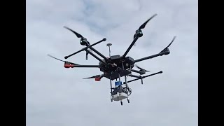
Types of UAVs Used in Aerial Surveying
Chapter 4 of 12
🔒 Unlock Audio Chapter
Sign up and enroll to access the full audio experience
Chapter Content
Types of UAVs Used in Aerial Surveying:
• Fixed-Wing Drones
– Long-range and endurance
– Suitable for large-scale surveys
– Require launch and landing space
• Multi-Rotor Drones
– Easy to maneuver
– Better for small or confined sites
– Shorter flight time, but highly precise
• Hybrid Drones
– Combines benefits of both fixed-wing and multi-rotor
– Used for specialized surveying operations
Detailed Explanation
Different types of UAVs are used in aerial surveying according to the specific requirements of the survey. Fixed-wing drones are known for their long-range capabilities, making them ideal for large surveys. Multi-rotor drones are easier to control and suitable for smaller areas but typically have shorter flight times. Hybrid drones combine features from both types, offering flexibility for various surveying needs.
Examples & Analogies
Choosing the right drone is like picking the right vehicle for a trip. A fixed-wing drone is like a long-haul truck, great for cross-country trips, while a multi-rotor drone is like a compact car, perfect for navigating city streets and tighter spaces.
Sensors and Payloads in Aerial Surveying
Chapter 5 of 12
🔒 Unlock Audio Chapter
Sign up and enroll to access the full audio experience
Chapter Content
Sensors and Payloads in Aerial Surveying:
• RGB Cameras
– Used for basic aerial imagery
– High-resolution (20MP or more)
• Multispectral and Hyperspectral Sensors
– Used for environmental monitoring, agriculture
– Can capture beyond visible spectrum
• Thermal Cameras
– For heat mapping, pipeline inspections
• LiDAR Sensors
– Laser-based, capable of penetrating vegetation
– Ideal for generating high-resolution 3D models
• Photogrammetric Cameras
– Optimized for orthophoto and 3D reconstruction
Detailed Explanation
A wide array of sensors and payloads can be used in aerial surveying, depending on the type of data required. RGB cameras provide standard images, while multispectral and hyperspectral sensors capture data beyond what the human eye can see, useful in agriculture and environmental studies. Thermal cameras can detect heat differences, which is useful for inspecting pipelines. LiDAR sensors are essential for creating detailed 3D models as they can penetrate vegetation. Photogrammetric cameras are specifically designed for creating orthophotos and 3D reconstructions.
Examples & Analogies
Think of the sensors as different types of glasses. Just as you would wear sunglasses to reduce glare or prescription glasses to see clearly, drones use various sensors to capture specific data tailored to different surveying needs, from general imagery to detailed thermal readings.
Survey Planning and Flight Execution
Chapter 6 of 12
🔒 Unlock Audio Chapter
Sign up and enroll to access the full audio experience
Chapter Content
Survey Planning and Flight Execution:
• Site Assessment
– Understanding terrain, airspace restrictions
– Weather and visibility conditions
• Mission Planning Software
– Tools like DJI GS Pro, Pix4Dcapture
– Inputs: altitude, overlap, area coverage, camera angle
• Flight Parameters
– Flight height (typically 60–120 m)
– Overlap (80% front, 60% side)
– Ground Sampling Distance (GSD)
• Automated Flight Execution
– Pre-programmed route
– Live monitoring and telemetry
– Redundancy and return-to-home features
Detailed Explanation
Effective aerial surveying requires meticulous planning and execution. It begins with assessing the survey site, evaluating terrain, airspace regulations, and weather conditions. Mission planning software helps in determining flight parameters, such as how high to fly and the areas to cover, ensuring proper overlap in images to avoid gaps in the data. Automated flight execution allows drones to follow a programmed route while monitoring in real-time, enhancing safety and efficiency.
Examples & Analogies
Survey planning is like preparing for a long-distance hike. You need to know the terrain, check the weather, and plan your route carefully. Just like a hiker would use a map and GPS to ensure they stay on course, drone operators use sophisticated software to plan their missions accurately.
Data Acquisition Techniques
Chapter 7 of 12
🔒 Unlock Audio Chapter
Sign up and enroll to access the full audio experience
Chapter Content
Data Acquisition Techniques:
• Image Capture
– Geotagged images captured at regular intervals
– Consistent lighting and low wind conditions preferred
• LiDAR Point Cloud Acquisition
– Thousands of points per second collected
– Includes elevation, reflectivity, and time-of-flight data
• Data Backup and Transfer
– Post-flight retrieval of SD card or via Wi-Fi
– Secure data management
Detailed Explanation
Data acquisition in aerial surveying involves capturing a variety of images and data using drones. For image capture, geotagged photos are taken at regular intervals to ensure spatial accuracy, ideally in consistent lighting and calm conditions for best results. LiDAR surveys collect extensive point cloud data rapidly, which provides critical elevation and reflectivity information. After flights, data must be securely backed up, either via direct retrieval or wireless transfer.
Examples & Analogies
Acquiring data is like taking a series of photographs during a family event. You want to capture moments (or images) consistently, making sure they are saved safely for later enjoyment. Similarly, drones capture extensive datasets during their flights to create a comprehensive overview of the area.
Photogrammetry and Data Processing
Chapter 8 of 12
🔒 Unlock Audio Chapter
Sign up and enroll to access the full audio experience
Chapter Content
Photogrammetry and Data Processing:
• Structure from Motion (SfM)
– 3D models from overlapping 2D images
– Point cloud generation
• Orthophoto Generation
– Geo-rectified image mosaics
– Accurate scale and minimal distortion
• Digital Elevation Models (DEM/DTM)
– DEM: elevation of natural and built features
– DTM: bare earth surface without vegetation/buildings
• Point Cloud Processing
– Classification (ground, vegetation, structures)
– Mesh generation for 3D visualization
• Software Tools
– Pix4D, Agisoft Metashape, DroneDeploy, RealityCapture
Detailed Explanation
Photogrammetry and data processing are vital in converting raw data from aerial surveys into useful outputs. Structure from Motion (SfM) allows the creation of detailed 3D models from 2D imagery by analyzing the overlapping sections of photos. Orthophotos are generated by stitching together geo-rectified images to create precise mosaics. Digital Elevation Models represent the elevation of surface features, while deriving the bare earth surface requires processing techniques. Software tools are used to manage all these processes effectively.
Examples & Analogies
Think of photogrammetry like creating a detailed puzzle. The overlapping images are the individual pieces, and the software assembles them to create a clear picture (or 3D model) of the area surveyed, just as you meticulously fit together puzzle pieces to complete an image.
Accuracy and Ground Control
Chapter 9 of 12
🔒 Unlock Audio Chapter
Sign up and enroll to access the full audio experience
Chapter Content
Accuracy and Ground Control:
• Ground Control Points (GCPs)
– Physically marked and surveyed points
– Improve georeferencing accuracy
• RTK and PPK Drones
– Real-Time Kinematic (RTK) and Post-Processed Kinematic (PPK)
– Offer centimeter-level positional accuracy
• Check Points (CPs)
– Used to independently verify the output accuracy
Detailed Explanation
Accuracy in aerial surveying relies heavily on the use of Ground Control Points (GCPs), which are strategically placed physical markers that help improve the accuracy of georeferenced data. Drones equipped with RTK technology can provide real-time positioning information, achieving centimeter-level accuracy. PPK drones, on the other hand, apply corrections after the flight to achieve high precision. Check Points (CPs) are additional reference points used to validate the results post-survey.
Examples & Analogies
Imagine trying to draw a precise map of your neighborhood. If you use fixed markers as reference points (like street corners), you can ensure that the entire drawing is accurate. Similarly, GCPs are the markers helping operators maintain the precision of aerial maps.
Applications in Civil Engineering
Chapter 10 of 12
🔒 Unlock Audio Chapter
Sign up and enroll to access the full audio experience
Chapter Content
Applications in Civil Engineering:
• Topographical Mapping
– Creation of contour maps, slope analysis
– Planning and design of infrastructure
• Construction Monitoring
– Site progress tracking
– Volume calculations (cut and fill analysis)
• Highway and Railway Projects
– Route alignment, embankment analysis
– Corridor mapping
• Bridge and Dam Inspection
– High-resolution imagery for structural analysis
– Thermal and IR surveys for crack and moisture detection
• Urban Planning and Land Use Mapping
– 3D modeling for zoning and development planning
• Disaster Management
– Rapid mapping of landslides, floods
– Damage assessment and rescue planning
Detailed Explanation
Aerial surveying plays a crucial role in various civil engineering applications. It facilitates topographical mapping, enabling engineers to understand terrain features for infrastructure development. Regular monitoring of construction sites allows for timely progress checks and volume calculations. In transport projects like highways and railways, aerial mapping helps in planning route alignments. Inspections of bridges and dams benefit from high-resolution imagery and thermal sensors, while urban planning relies on 3D models for effective zoning. Additionally, aerial surveys are vital in disaster management, providing essential data for damage assessment and rescue operations.
Examples & Analogies
Think of aerial surveying as providing a detailed map of a city being built. Just as a city planner would need a comprehensive overview to make informed decisions about roads and facilities, civil engineers use UAV data to enhance their projects, from initial design stages to ongoing inspections.
Challenges in Aerial Surveying
Chapter 11 of 12
🔒 Unlock Audio Chapter
Sign up and enroll to access the full audio experience
Chapter Content
Challenges in Aerial Surveying:
• Weather Dependency
– Wind, rain, and cloud cover affect data quality
• Battery and Range Limitations
– Restrict flight duration and area coverage
• Regulatory Constraints
– Airspace clearance, drone registration (DGCA in India)
• Data Processing Requirements
– High-end computing resources needed
– Data privacy and storage issues
Detailed Explanation
Despite numerous advantages, aerial surveying faces several challenges. Weather conditions significantly impact data quality; strong winds, rain, or cloud cover can hinder flights and compromise the information collected. Battery life limits how long the drones can operate and how much terrain they can cover in a single flight. Additionally, regulatory constraints—such as needing to secure permissions for flights—can complicate operations. Finally, processing the collected data demands considerable computing resources, and issues surrounding data privacy and storage need careful management.
Examples & Analogies
Consider a photographer who wants to shoot a cityscape but has to deal with bad weather. Just like how inclement weather can ruin a photoshoot, adverse conditions can severely limit the effectiveness of aerial surveys, despite the fantastic technology available.
Future Trends in Aerial Mapping
Chapter 12 of 12
🔒 Unlock Audio Chapter
Sign up and enroll to access the full audio experience
Chapter Content
Future Trends in Aerial Mapping:
• AI-Based Automated Feature Extraction
– Identify roads, buildings, trees from images using deep learning
• Real-Time 3D Mapping
– Onboard processing during flight
• Integration with BIM and GIS
– Enhance smart city planning, infrastructure design
• Swarm Drones
– Multiple drones working together for faster mapping
• Cloud-Based Processing and Analytics
– Access to high computing power and collaborative platforms
Detailed Explanation
The future of aerial mapping is poised for exciting advancements. With AI, drones will soon be able to automatically identify features in landscapes, such as roads and buildings, using deep learning techniques. Real-time 3D mapping will allow data to be processed during flights, streamlining operations. Furthermore, there will be greater integration with Building Information Modeling (BIM) and Geographic Information Systems (GIS) for more efficient urban planning. The development of swarms of drones working in unison promises faster data collection, while cloud-based processing offers powerful computational capabilities and collaborative tools for teams.
Examples & Analogies
Think of the future of aerial mapping as a group of people working together to complete a big puzzle. Instead of working individually, they collaborate to piece the puzzle together much faster and more accurately, just like swarms of drones will enable quicker and more precise surveys.
Key Concepts
-
Unmanned Aerial Vehicles (UAVs): Essential tools in aerial surveying for capturing high-resolution data.
-
LiDAR: A key sensor technology for generating detailed 3D models and terrain maps.
-
Ground Control Points (GCPs): Key to improving geospatial accuracy in drone surveys.
-
Photogrammetry: The process of obtaining reliable measurements through photography.
Examples & Applications
Using drones for monitoring construction site progress can reduce project delays and improve resource allocation.
LiDAR-equipped drones are utilized in forestry to assess vegetation canopy and ground models.
Memory Aids
Interactive tools to help you remember key concepts
Rhymes
In the sky, UAVs go high, to map the earth without a lie.
Stories
Once, a drone named Data flew high, capturing images of fields, rivers, and the nearby pie shop. Every day, Data helped the engineers understand the land and plan for new roads without putting anyone in danger.
Memory Tools
GCP: Ground Control Points, Count on Precision!
Acronyms
Drones for Safety and Accuracy
DSA (Drones
Safety
Accuracy).
Flash Cards
Glossary
- UAV
Unmanned Aerial Vehicle, commonly known as a drone, used for aerial surveying.
- LiDAR
Light Detection and Ranging, a remote sensing method used to examine the surface of the Earth.
- Ground Control Points (GCPs)
Marked points on the ground used to improve the accuracy of geospatial data in aerial surveys.
- Photogrammetry
The use of photography to measure and create maps from spatial data.
- RTK
Real-Time Kinematic, a satellite navigation technique used to enhance the precision of position data.
- PPK
Post-Processed Kinematic, a technique similar to RTK but data corrections applied post-flight.
Reference links
Supplementary resources to enhance your learning experience.