
Survey Planning and Flight Execution
Enroll to start learning
You’ve not yet enrolled in this course. Please enroll for free to listen to audio lessons, classroom podcasts and take practice test.
Interactive Audio Lesson
Listen to a student-teacher conversation explaining the topic in a relatable way.
Site Assessment
🔒 Unlock Audio Lesson
Sign up and enroll to listen to this audio lesson

Today, we will begin our discussion on survey planning with site assessment. Can anyone tell me why site assessment is important in this context?

I think it’s to make sure we are aware of the restrictions and the area we will be flying over?
Exactly, great point! Site assessment involves understanding the terrain and identifying any airspace restrictions, along with assessing weather conditions. We can remember this with the acronym 'TWR' - Terrain, Weather, and Restrictions. Can someone explain why these factors matter?

These factors can affect our flight path and the data we collect.
Yes! It's crucial to adapt our flight plan based on these assessments. Let’s think about a scenario where visibility is poor; how would that impact our data collection?

We might get blurry images, which could lead to inaccurate data.
Excellent observation! Always assess these factors to avoid data quality issues. Remember, plan for success by understanding TWR.
Mission Planning Software
🔒 Unlock Audio Lesson
Sign up and enroll to listen to this audio lesson

Next, let's dive into mission planning software like DJI GS Pro and Pix4Dcapture. What do these tools do?

They help set parameters for the flight, right?
Correct! These programs allow users to input parameters like altitude, image overlap, and camera angles. Do you remember the recommended overlap percentages?
Yes, it’s 80% front and 60% side.
Exactly! That ensures we get comprehensive coverage. What might happen if we set lower overlap?
We might miss some areas or not have enough data to stitch images together properly.
Right again! Utilizing mission planning software optimizes our data acquisition, reducing the risk of missing critical areas. Always double-check your inputs!
Flight Parameters and Automation
🔒 Unlock Audio Lesson
Sign up and enroll to listen to this audio lesson
Now let’s talk about the flight parameters. We discussed the standard flight height should be between 60 to 120 meters. Why might we choose a higher altitude?
To cover a larger area with fewer images, possibly.
Spot on! However, we also need to consider the level of detail we want. Now let's discuss automated flight execution. What benefits does automation provide?
It can help us fly predetermined routes without needing a pilot to control it during the flight.
Exactly! Automation leads to less human error and more efficient data collection. What other features can enhance safety in automated flights?
Redundancy features and the return-to-home function!
Great! These features are crucial for ensuring safety and operational reliability during the flight. Effective automation can help make our workflow much smoother!
Introduction & Overview
Read summaries of the section's main ideas at different levels of detail.
Quick Overview
Standard
In this section, we explore essential components of effective aerial survey planning and execution, including site assessment, mission planning software, and automated flight execution, ensuring precision and efficiency in data collection.
Detailed
Survey Planning and Flight Execution
In aerial surveying, the success of a mission largely hinges on the planning and execution phases. This section covers the key elements required for successful survey planning and flight execution using UAVs.
Key Components of Survey Planning
Site Assessment
The first step involves performing a thorough site assessment to understand the terrain and identify any airspace restrictions, as well as evaluating weather and visibility conditions. This phase ensures that the chosen operate parameters are appropriate for the specific environment.
Mission Planning Software
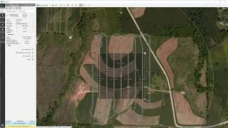
Various tools such as DJI GS Pro and Pix4Dcapture assist in mission planning. Inputs such as altitude, image overlap, area coverage, and camera angle must be carefully set to optimize the outcomes of each survey.
Flight Parameters
During flight execution, key parameters like flight height (commonly between 60-120 m), overlap percentages (80% front and 60% side), and Ground Sampling Distance (GSD) are critical to achieving high resolution and accuracy in the collected data.
Automated Flight Execution
Automation plays a significant role in modern aerial surveying. The use of pre-programmed routes, live monitoring, and telemetry allows for better efficiency and safety. Redundancy protocols and return-to-home features enhance operational security, making automated flights more reliable.
Overall, meticulous planning and effective execution are determinative for the quality and utility of data gathered during aerial surveys.
Youtube Videos


Audio Book
Dive deep into the subject with an immersive audiobook experience.
Site Assessment
Chapter 1 of 4
🔒 Unlock Audio Chapter
Sign up and enroll to access the full audio experience
Chapter Content
• Site Assessment
– Understanding terrain, airspace restrictions
– Weather and visibility conditions
Detailed Explanation
Site assessment is the initial step in planning for an aerial survey. This involves evaluating the physical characteristics of the land, checking any airspace restrictions that may limit where and how aerial vehicles can operate, and considering weather conditions that may affect visibility and safety. Understanding these elements helps ensure that the flight will be conducted safely and effectively.
Examples & Analogies
Think of site assessment like preparing for a picnic. You need to check if the park is open (airspace restrictions), look at the weather forecast to make sure it won’t rain (visibility conditions), and understand the terrain to choose a good spot with a nice view (terrain assessment).
Mission Planning Software
Chapter 2 of 4
🔒 Unlock Audio Chapter
Sign up and enroll to access the full audio experience
Chapter Content
• Mission Planning Software
– Tools like DJI GS Pro, Pix4Dcapture
– Inputs: altitude, overlap, area coverage, camera angle
Detailed Explanation
Mission planning software helps operators design the flight path of the UAV before the mission begins. This software allows users to input critical parameters like altitude (how high the drone will fly), overlap (how much the images will overlap each other), the area to be covered, and the angle of the camera. Proper planning ensures that all necessary data is captured thoroughly.
Examples & Analogies
Consider mission planning software like a map app on your phone when planning a road trip. You enter your destination, decide on the fastest route, and check for any stops along the way (like fuel stations or restaurants). Similarly, mission planning allows pilots to prepare for capturing images efficiently.
Flight Parameters
Chapter 3 of 4
🔒 Unlock Audio Chapter
Sign up and enroll to access the full audio experience
Chapter Content
• Flight Parameters
– Flight height (typically 60–120 m)
– Overlap (80% front, 60% side)
– Ground Sampling Distance (GSD)
Detailed Explanation
Flight parameters are essential measurements that dictate how the drone performs during its operation. The flight height (the altitude at which the drone flies) affects the range of data collected. Overlap refers to how much the drone's images overlap each other in both forward and sideways movements, which is integral for generating accurate models. Ground Sampling Distance (GSD) defines the spatial resolution of the images obtained and how finely detailed the captured data will be.
Examples & Analogies
Consider the flight parameters like the settings on your camera when taking a photo. If you want a clearer and more detailed picture, you may choose a specific focal length (flight height) and adjust how many pictures you want from various angles (overlap). This ensures that every detail is captured perfectly.
Automated Flight Execution
Chapter 4 of 4
🔒 Unlock Audio Chapter
Sign up and enroll to access the full audio experience
Chapter Content
• Automated Flight Execution
– Pre-programmed route
– Live monitoring and telemetry
– Redundancy and return-to-home features
Detailed Explanation
Automated flight execution refers to the drone following a pre-programmed route without needing manual control during the entire flight. This process includes live monitoring to track the drone's status and telemetry data (like its location and battery level). Redundant systems provide safety features like 'return-to-home', which allows the drone to safely return to its starting point if there is a malfunction or loss of connection.
Examples & Analogies
Imagine setting a destination on a GPS for your car and letting it guide you automatically. As you drive, the GPS informs you of your current location and alerts you to any issues along the way. Similarly, an automated drone flight relies on programming and monitoring to ensure it reaches its destination safely.
Key Concepts
-
Site Assessment: Evaluating terrain, restrictions, and visibility conditions is critical in planning an effective survey.
-
Mission Planning Software: Utilizing software to set parameters optimizes flight efficiency and enhances data collection quality.
-
Flight Parameters: Key elements such as flight height, overlap, and GSD directly influence the accuracy and quality of survey data.
-
Automated Flight Execution: Automation increases efficiency and safety by using pre-programmed routes and monitoring features.
Examples & Applications
Using Pix4Dcapture, a drone can be programmed to fly a grid over a construction site to gather imagery for site analysis.
By increasing the flight height from 60m to 100m, the drone can cover 50% more area in a single flight, though with a trade-off in image resolution.
Memory Aids
Interactive tools to help you remember key concepts
Rhymes
For a survey that’s neat, assess before fleet; TWR helps you soar, keep your data galore.
Stories
Imagine a pilot named Sam who always ensured TWR was his plan before every flight—this way, he never missed a critical detail!
Memory Tools
Remember 'TOP' for your flight parameters: T for height, O for overlap, P for GSD.
Acronyms
Use 'DFT' to remember the stages of a UAV mission
for Do the assessment
for Formulate the plan
and T for Takeoff!
Flash Cards
Glossary
- Site Assessment
The process of evaluating a location to understand terrain, airspace restrictions, and weather conditions before executing a survey.
- Mission Planning Software
Tools that assist in setting flight parameters such as altitude, overlap, and camera angles for UAV operations.
- Flight Parameters
Specific settings that govern the altitude, overlap, and Ground Sampling Distance during UAV flights.
- Automated Flight Execution
Utilizing pre-programmed flight paths and telemetry systems to conduct surveys without manual control.
Reference links
Supplementary resources to enhance your learning experience.