
Force for Drifting
Enroll to start learning
You’ve not yet enrolled in this course. Please enroll for free to listen to audio lessons, classroom podcasts and take practice test.
Interactive Audio Lesson
Listen to a student-teacher conversation explaining the topic in a relatable way.
Introduction to Continental Drift
🔒 Unlock Audio Lesson
Sign up and enroll to listen to this audio lesson

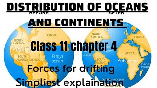
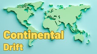
Today we'll explore the continental drift theory, proposed by Alfred Wegener in 1912. He suggested that all continents were once connected in a supercontinent called Pangaea.

What made him think that Pangaea existed?
Great question! He noted that coastlines, like those of Africa and South America, matched perfectly, resembling puzzle pieces.

Did he provide any evidence for this theory?
Yes! For example, he observed the distribution of similar fossils on different continents. This suggests they were once joined.

How did he explain the movement of continents?
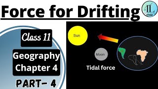
Wegener proposed that the movement was caused by two forces: pole-fleeing force and tidal force, linked to the Earth's rotation and gravitational pull from the Sun and Moon.

Are these forces still accepted today?
Mostly no. While Wegener was correct about the movement, the forces he proposed were later deemed inadequate.
To summarize, Wegener’s observation of matching coastlines and fossil distributions laid the groundwork for the continental drift theory, although more evidence was needed.
Evidence Supporting Continental Drift
🔒 Unlock Audio Lesson
Sign up and enroll to listen to this audio lesson

Now, let’s discuss specific evidence supporting continental drift, starting with the jig-saw fit of continents. Can anyone explain what this means?
It means the coastlines of continents, like Africa and South America, can fit together like pieces of a puzzle!
Exactly! Next, we have radiometric dating of rocks. What can we infer from this?
It shows that rocks of the same age are found across oceans, which adds to the idea that they were once connected.
What about tillite? How does that fit in?
Good point! Tillites found in different landmasses indicate past glaciation under similar climates, suggesting these lands were once close together.
And fossil distribution, right? Like the Mesosaurus?
That's it! Identical species found in geographically distant areas support continental connections in the past.
In summary, the jig-saw fit, radiometric dating, tillite evidence, and fossil distribution all strongly support Wegener's theory of continental drift.
Post-Drift Studies and Sea Floor Spreading
🔒 Unlock Audio Lesson
Sign up and enroll to listen to this audio lesson
Let’s move on to post-drift studies. After WWII, scientists discovered more about the ocean floors. What do you think they found?
Maybe they found mid-ocean ridges and volcanic activity?
Absolutely! This led Harry Hess to propose the sea floor spreading theory, suggesting that new crust is formed at mid-ocean ridges.
How does that relate to continental drift?
Great question! As new crust is pushed away from the ridges, continents are carried along, effectively moving them apart.
But what about the older crust?
It sinks back into the mantle at oceanic trenches, creating a cycle of crust formation and destruction.
And that led to the development of plate tectonics, right?
Exactly! Plate tectonics has become the widely accepted theory explaining the movement of continents over geological time.
To summarize, post-drift studies including sea floor spreading and the theory of plate tectonics have enhanced our understanding of continental movement significantly.
Introduction & Overview
Read summaries of the section's main ideas at different levels of detail.
Quick Overview
Standard
The section explores Alfred Wegener's theory of continental drift and the forces he proposed, including pole-fleeing and tidal forces. It discusses evidence supporting continental drift, such as the matching coastlines and fossil distributions, and introduces post-drift concepts like convection currents and plate tectonics.
Detailed
Force for Drifting
In this section, we delve into the theory of continental drift, pioneered by Alfred Wegener in 1912, which posits that continents were once part of a supercontinent called Pangaea, surrounded by a mega-ocean named Panthalassa. Wegener suggested that the continents gradually drifted apart due to forces such as polar-fleeing force and tidal force.
Evidence for Continental Drift
Key evidences supporting this theory include:
1. Jig-Saw-Fit: The coastlines of Africa and South America fit together remarkably, indicating they were once joined.
2. Differential Age of Rocks: Radiometric dating reveals that similar-aged rock formations exist across continents, suggesting they were once connected.
3. Tillite and Glacial Deposits: Tillite found in various continents points to shared climatic conditions due to proximity.
4. Fossil Distribution: Similar species found on different continents (e.g., Mesosaurus in South America and Africa) suggest a connected landmass.
Post-Drift Studies
The section transitions into post-drift studies, discussing hydrodynamic processes that contribute to continental movement. Post-WWII discoveries, such as ocean floor mapping, introduced the theory of sea floor spreading by Harry Hess, suggesting constant volcanic activity at mid-ocean ridges pushes the ocean floor apart. This led to the development of plate tectonics, which redefined our understanding of how tectonic plates interact.
Ultimately, the movement of these plates—driven by convection currents in the molten asthenosphere—explains the dynamics of continental drift and emphasizes the Earth's ever-changing geological landscape.
Youtube Videos


Audio Book
Dive deep into the subject with an immersive audiobook experience.
Wegener's Forces for Continental Drift
Chapter 1 of 3
🔒 Unlock Audio Chapter
Sign up and enroll to access the full audio experience
Chapter Content
Wegener suggested that the movement responsible for the drifting of the continents was caused by pole-fleeing force and tidal force. The polar-fleeing force relates to the rotation of the earth. You are aware of the fact that the earth is not a perfect sphere; it has a bulge at the equator. This bulge is due to the rotation of the earth. The second force that was suggested by Wegener — the tidal force — is due to the attraction of the moon and the sun that develops tides in oceanic waters. Wegener believed that these forces would become effective when applied over many million years. However, most scholars considered these forces to be totally inadequate.
Detailed Explanation
Wegener introduced two main forces that he believed caused the continents to drift: the polar-fleeing force and the tidal force. The polar-fleeing force is a result of the Earth's rotation, which causes a slight bulge at the equator. This means that as the Earth spins, there is a tendency for objects at the equator, including the continents, to move outward. The tidal force, on the other hand, is caused by the gravitational pull of the moon and sun, which creates tides in the ocean. Wegener thought that over millions of years, these forces would be strong enough to push the continents apart. However, many scientists during Wegener’s time disagreed and believed that these forces were too weak to bring about such significant movement.
Examples & Analogies
Think of the Earth as a spinning basketball. As it spins, the rubber surface bulges at the equator, similar to how we have the polar-fleeing force. Now, imagine if there were two people (the moon and sun) pulling on the basketball with strings. They can create small shifts, like tides in real water, but they don't have enough strength to move the entire basketball; similarly, during Wegener's time, scientists felt these forces were not sufficient to move continents.
Post-drift Studies and New Evidence
Chapter 2 of 3
🔒 Unlock Audio Chapter
Sign up and enroll to access the full audio experience
Chapter Content
It is interesting to note that for continental drift, most of the evidence was collected from the continental areas in the form of distribution of flora and fauna or deposits, like tillite. A number of discoveries during the post–World War II period added new information to geological literature. Particularly, the information collected from the ocean floor mapping provided new dimensions for the study of distribution of oceans and continents.
Detailed Explanation
After Wegener proposed his theory of continental drift, most evidence relied on observations from land areas, such as the distribution of plants and fossils. However, following World War II, scientists discovered a wealth of new information through ocean floor mapping. This new evidence changed the way geologists understood how continents and oceans interact. They could now see the physical features of the ocean bed, which provided insights into how continents moved apart and formed over time.
Examples & Analogies
Imagine trying to understand a story only by reading chapters from a book without looking at the illustrations. Now, if someone showed you a detailed map or graphic from the book, it would clarify a lot more about the storyline. Similarly, ocean floor mapping gave scientists a clearer picture of Earth's geological history, enabling them to understand the movement of continents in a more informed way.
Convection Current Theory
Chapter 3 of 3
🔒 Unlock Audio Chapter
Sign up and enroll to access the full audio experience
Chapter Content
Arthur Holmes in 1930s discussed the possibility of convection currents operating in the mantle portion. These currents are generated due to radioactive elements causing thermal differences in the mantle portion. Holmes argued that there exists a system of such currents in the entire mantle portion. This was an attempt to provide an explanation to the issue of force, on the basis of which contemporary scientists discarded the continental drift theory.
Detailed Explanation
Arthur Holmes proposed the idea that convection currents within the Earth's mantle were responsible for the movement of continents. These currents are caused by heat generated from radioactive elements that create thermal differences within the mantle. Hot material rises toward the surface, while cooler material sinks down, creating a cycle known as convection. This theory offered a more dynamic explanation for continental movement than Wegener's original ideas, leading scientists to question the adequacy of the continental drift theory.
Examples & Analogies
Think of a boiling pot of water on the stove. The heat from the burner warms the water at the bottom, causing it to rise. As the hot water reaches the top, it cools and then sinks again, creating a cycle. This behavior in the water is similar to the convection currents in the Earth's mantle, which can move the tectonic plates and, thus, the continents above.
Key Concepts
-
Pangaea: A supercontinent that existed millions of years ago.
-
Sea Floor Spreading: Process by which new oceanic crust forms and pushes the plates apart.
-
Plate Tectonics: Theory explaining the movement of Earth's plates.
-
Polar Fleeing Force: Force explaining the potential outward push of continents.
Examples & Applications
The fit of South America and Africa's coastlines is often cited as a classic example of the evidence for continental drift.
Fossils of the plant glossopteris found in both South America and Africa support the idea that these continents were once connected.
Memory Aids
Interactive tools to help you remember key concepts
Rhymes
Continents drift, they shift and sway, Pangaea was here, then went away.
Stories
Once upon a time, the continents were friends, hugging together until their separation began where each went into their own adventures, floating on the ocean like it was a grand stage.
Memory Tools
Fossils, fit, and flow—three evidences that prove, we once were one, now apart we move.
Acronyms
DRAFT
Drift
Rocks
Age
Fit
Tides—key concepts supporting continental drift.
Flash Cards
Glossary
- Continental Drift
Theory that continents were once joined as a supercontinent Pangaea and have drifted apart over geological time.
- Pangaea
The hypothetical supercontinent that existed around 335 million years ago, from which all present continents have since drifted.
- Sea Floor Spreading
The process by which new oceanic crust is formed through volcanic activity at mid-ocean ridges and moves away from the ridges.
- Plate Tectonics
The scientific theory addressing the movements of the Earth's lithosphere divided into tectonic plates.
- Tidal Force
The gravitational force exerted by the Moon and Sun that causes tides and is hypothesized by Wegener to aid in continental movement.
- Polar Fleeing Force
The force acting on objects at the equator due to the Earth’s rotation that could potentially push continents outward.
- Radiometric Dating
A technique used to date materials based on the radioactive decay of isotopes, providing evidence for the relative ages of geological formations.
- Glacial Tillite
A sedimentary rock formed from glacial deposits, supporting evidence of past glaciation across continents.
- Fossil Distribution
The geographical spread of fossils that can indicate historical connections between landmasses.
- MidOcean Ridges
Underwater mountain systems formed by plate tectonics and seafloor spreading, significant for volcanic activity.
Reference links
Supplementary resources to enhance your learning experience.