
Use of Intensity in Seismic Hazard Assessment
Enroll to start learning
You’ve not yet enrolled in this course. Please enroll for free to listen to audio lessons, classroom podcasts and take practice test.
Interactive Audio Lesson
Listen to a student-teacher conversation explaining the topic in a relatable way.
Introduction to Intensity in Seismic Hazard Assessment
🔒 Unlock Audio Lesson
Sign up and enroll to listen to this audio lesson

Today we're going to explore how intensity is utilized in seismic hazard assessment. Can anyone explain what seismic intensity measures?

Isn't it how strong the ground shakes during an earthquake?
Exactly! Intensity measures the effects of an earthquake at specific locations. It's crucial for assessing how much damage an earthquake can cause.

So, does intensity relate to where the earthquake is felt more strongly?
Yes! The distance from the epicenter and local geological conditions both affect intensity. This leads us to the concept of microzonation. Can anyone tell me what that is?

Does it involve mapping different areas based on their seismic risk?
Exactly! Microzonation maps combine observed intensities and geological data to classify areas into seismic zones.
To summarize, understanding intensity helps in defining risk zones and ensuring safer infrastructure by considering local conditions.
Role of Intensity Scales in Hazard Assessment
🔒 Unlock Audio Lesson
Sign up and enroll to listen to this audio lesson

Let’s dive deeper into the specific intensity scales used in seismic hazard assessment. Who can name one of these scales?

The Modified Mercalli Intensity scale, right?
Good job! The MMI scale ranges from I to XII based on human perception and structural damage. Can anyone give me an example of what an MMI level indicates?
I think level I means 'not felt except by a few'?
Correct! And what about level XII?
It means 'total destruction'!
Exactly! These measures help in risk zonation and designing safer buildings based on expected ground motion.
To recap, MMI is a comprehensive tool to communicate seismic effects based on localized experiences.
Introduction & Overview
Read summaries of the section's main ideas at different levels of detail.
Quick Overview
Standard
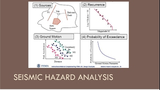
The section emphasizes the role of intensity in creating microzonation maps and classifying seismic risk zones, detailing how observed intensities contribute to understanding seismic hazards for engineering and safety.
Detailed
In seismic hazard assessment, intensity measures play a crucial role in understanding how earthquakes affect various locations differently. Intensity evaluates the ground shaking effects and damage observed in specific areas. This section elaborates on the integration of intensity with geological data to produce microzonation maps, facilitating the classification of areas into seismic zones. For example, the Modified Mercalli Intensity (MMI) and Medvedev–Sponheuer–Karnik (MSK) scales are pivotal tools used for assessing seismic intensity, which aids in deriving design ground motion parameters essential for engineering practices. The application of intensity through these scales allows for informed risk assessment and improved design strategies for earthquake-resistant structures.
Youtube Videos


Audio Book
Dive deep into the subject with an immersive audiobook experience.
Microzonation Maps
Chapter 1 of 3
🔒 Unlock Audio Chapter
Sign up and enroll to access the full audio experience
Chapter Content
• Microzonation Maps: Combine observed intensities with geological data.
Detailed Explanation
Microzonation maps are specialized maps that show how different areas react to seismic activity based on the intensity of shaking observed and the geological characteristics of those areas. By analyzing the intensity reported from various locations, engineers and geologists can create detailed maps that help in understanding how likely an area is to experience intense shaking during an earthquake.
Examples & Analogies
Think of microzonation maps like a weather forecast for earthquakes. Just as meteorologists use different data points (like humidity, temperature, and wind) to predict whether it will rain in different neighborhoods, scientists use data about intensity and geology to predict how strong the shaking will be in different parts of a city or region.
Risk Zonation
Chapter 2 of 3
🔒 Unlock Audio Chapter
Sign up and enroll to access the full audio experience
Chapter Content
• Risk Zonation: Modified Mercalli or MSK intensities help classify areas into seismic zones (e.g., Zone II–V in India).
Detailed Explanation
Risk zonation is the process of categorizing areas based on the levels of earthquake risk they face. Different intensities reported by scales like Modified Mercalli or MSK are used to classify these areas into zones, such as Zone II to Zone V in India. Each zone represents a different level of risk and helps inform building regulations and emergency preparedness efforts.
Examples & Analogies
Imagine risk zonation like zoning laws in a city. Just as a city may have different rules for building heights in residential versus commercial areas, risk zonation helps set different construction standards in areas based on how likely they are to experience damaging earthquakes.
Design Ground Motion Parameters
Chapter 3 of 3
🔒 Unlock Audio Chapter
Sign up and enroll to access the full audio experience
Chapter Content
• Design Ground Motion Parameters: Intensity indirectly used to derive design spectrum parameters.
Detailed Explanation
Design ground motion parameters are specific criteria used in engineering to ensure buildings can withstand earthquakes. Intensity plays a critical role in determining these parameters indirectly by informing how much shaking structures need to be designed to endure safely. It provides a basis for engineers to create structures that can resist the expected seismic forces.
Examples & Analogies
Think of design ground motion parameters like building codes for a high-rise in a windy area. Just as engineers take wind speed into account to ensure a tall building won’t sway too much, they use intensity data to figure out how much shaking buildings might have to endure and design accordingly to keep people safe.
Key Concepts
-
Seismic Intensity: Evaluation of earthquake effects at specific locations, varies with distance and geological conditions.
-
Microzonation: A detailed mapping approach combining observed intensities and geological data for assessing seismic risks.
-
Risk Zonation: Classification of areas into seismic zones to mitigate earthquake hazards.
Examples & Applications
The 2001 Bhuj Earthquake demonstrated the application of intensity measures in assessing damage and defining risk zones.
Microzonation maps indicate areas of varying seismic risk within a region, highlighting the importance of local geology and construction practices.
Memory Aids
Interactive tools to help you remember key concepts
Rhymes
Intensity's no mystery, it reveals our quake's history!
Stories
Imagine a town where the ground shook less at one end. The buildings there stayed strong while the other end was laid to rest. Understanding that was key, microzonation saved the day!
Memory Tools
To remember the intensity types: M - Movement, M - Measure, I - Intensity Scale.
Acronyms
MMI
Measure
Monitor
Interpret for Quake Effects.
Flash Cards
Glossary
- Seismic Intensity
A measure of the effects of an earthquake at specific locations, often assessed using scales like the Modified Mercalli Intensity scale.
- Microzonation
The process of creating detailed maps that specify local seismic hazards based on observed intensity and geological characteristics.
- Modified Mercalli Intensity (MMI)
A qualitative scale ranging from I (not felt) to XII (total destruction) that measures damage and human perception of shaking.
- Risk Zonation
The classification of areas into seismic zones based on the levels of potential earthquake hazard and risk.
Reference links
Supplementary resources to enhance your learning experience.