
Impact of Plate Tectonics on Infrastructure Planning
Enroll to start learning
You’ve not yet enrolled in this course. Please enroll for free to listen to audio lessons, classroom podcasts and take practice test.
Interactive Audio Lesson
Listen to a student-teacher conversation explaining the topic in a relatable way.
Site Selection Criteria
🔒 Unlock Audio Lesson
Sign up and enroll to listen to this audio lesson

Let's begin our discussion on the site selection criteria used in infrastructure planning. Why do you think selecting the right site is important for engineers working in seismically active areas?

I think it's because certain areas are more likely to experience earthquakes or landslides.

Yeah, and if they build in those areas, it could lead to structural failures.
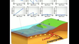
Exactly! Engineers must avoid fault zones, which are areas with active faults. Can anyone name another important criterion?

What about avoiding liquefaction-prone areas?
That's correct! Liquefaction can cause ground to behave like a liquid during an earthquake, which is very dangerous. Remember the acronym **LFL**: Liquefaction, Fault zones, Landslide zones. Let's summarize: it's crucial to avoid fault zones, consider liquefaction risks, and identify landslide-prone areas.
Zonation Maps
🔒 Unlock Audio Lesson
Sign up and enroll to listen to this audio lesson

Now that we've covered site selection, let’s talk about zonation maps. What do you think these maps tell us?

They probably show different seismic zones and how they might be affected by earthquakes.
And help engineers understand ground motion expectations?
Correct! Zonation maps help determine design basis ground motion and peak ground acceleration. This ensures structures can withstand the expected seismic forces. A quick way to recall this is the mnemonic **MAP**: Motion, Acceleration, Planning. Let's discuss the importance of seismic microzonation next.
Seismic Microzonation
🔒 Unlock Audio Lesson
Sign up and enroll to listen to this audio lesson
Seismic microzonation is crucial, especially for critical infrastructures. Can anyone name some examples of critical infrastructure that need to consider seismic risks?
Dams and nuclear plants come to mind.
What about bridges? They need to be robust too, right?
Absolutely! Dams, nuclear power plants, and bridges all require a detailed analysis of local geology to ensure safety during seismic events. Remember the acronym **DNB**: Dams, Nuclear plants, Bridges for critical infrastructure assessments.
Introduction & Overview
Read summaries of the section's main ideas at different levels of detail.
Quick Overview
Standard
The impact of plate tectonics on infrastructure planning is paramount. Engineers must consider site selection criteria, use zonation maps, and carry out seismic microzonation to ensure resilience against seismic activities, thereby enhancing the safety and sustainability of structures in seismically active areas.
Detailed
Impact of Plate Tectonics on Infrastructure Planning
The movement and interaction of tectonic plates significantly influence infrastructure planning, particularly in seismically active regions. Understanding these geological processes allows civil engineers to take crucial preventative measures against earthquakes and other geological hazards.
Site Selection Criteria
When planning new infrastructure, engineers prioritize site selection criteria that include:
- Avoidance of Fault Zones: Structures must be located away from active fault lines to minimize risk from earthquakes.
- Liquefaction-Prone Areas: Engineers assess soil stability since certain soil types can lose strength when subjected to seismic shaking.
- Landslide Zones: Areas prone to landslides are carefully studied to avoid potential disasters.
Zonation Maps
Zonation maps help engineers understand the geophysical characteristics of a region. These maps are used to determine:
- Design Basis Ground Motion: Understanding the expected ground motion helps in designing structures that can withstand seismic forces.
- Peak Ground Acceleration: This data is critical in estimating the amount of ground shaking a site may experience during an earthquake.
Seismic Microzonation
Seismic microzonation entails a detailed analysis of local soil and geological conditions to identify specific hazards associated with seismic activity. This process is especially important for critical infrastructure, such as:
- Dams: Must be designed to withstand seismic loads due to their potential to cause catastrophic flooding.
- Nuclear Power Plants: Require stringent safety measures given the potential consequences of failure.
- Bridges: Essential for transportation networks, requiring robustness to ensure they remain operational during seismic events.
Understanding the impact of plate tectonics is essential for ensuring the safety and resilience of infrastructure, making it a focal point of earthquake engineering.
Youtube Videos


Audio Book
Dive deep into the subject with an immersive audiobook experience.
Site Selection Criteria
Chapter 1 of 3
🔒 Unlock Audio Chapter
Sign up and enroll to access the full audio experience
Chapter Content
• Site Selection Criteria: Avoidance of fault zones, liquefaction-prone areas, and landslide zones.
Detailed Explanation
Site selection is crucial in infrastructure planning, particularly in earthquake-prone areas. Engineers and planners must avoid locations where there are known fault zones, which are areas susceptible to tectonic movement and earthquakes. Additionally, sites at risk of liquefaction, a phenomenon where saturated soil loses its strength due to seismic shaking, should be avoided. Landslide zones, which can be triggered by earthquakes, also pose significant risks to infrastructure stability. Therefore, careful assessment and planning help ensure safety and longevity of buildings and structures.
Examples & Analogies
Think of site selection like choosing a spot to build a treehouse. You wouldn’t want to build it under a tree with weak branches or near a slope where landslides could happen after rain. Similarly, engineers evaluate and select locations carefully to prevent future disasters.
Zonation Maps
Chapter 2 of 3
🔒 Unlock Audio Chapter
Sign up and enroll to access the full audio experience
Chapter Content
• Zonation Maps: Used to determine design basis ground motion and peak ground acceleration.
Detailed Explanation
Zonation maps are tools that categorize areas based on their seismic risk. These maps help engineers understand how much shaking to expect during an earthquake based on the geological characteristics of the area. This determination is crucial for designing buildings that can withstand potential seismic forces. By analyzing these maps, planners can select appropriate building materials, construction techniques, and safety features to minimize earthquake damage.
Examples & Analogies
Imagine going into a new fishing spot and checking a tide chart before you cast your line. Just like fishermen use charts to anticipate conditions on the water, engineers use zonation maps to anticipate ground motion, making better design decisions for safety.
Seismic Microzonation
Chapter 3 of 3
🔒 Unlock Audio Chapter
Sign up and enroll to access the full audio experience
Chapter Content
• Seismic Microzonation: Finer-scale hazard assessment, particularly for critical infrastructure (dams, nuclear plants, bridges).
Detailed Explanation
Seismic microzonation is a detailed analysis that focuses on smaller areas to assess specific seismic hazards. This is especially important for critical infrastructure, such as dams or nuclear power plants, where failure could have catastrophic consequences. By examining factors like soil type and local geology, engineers can create highly localized seismic hazard assessments, leading to more tailored design strategies that enhance safety and resilience against earthquakes.
Examples & Analogies
Think of seismic microzonation like studying weather patterns within a city when planning an outdoor event. If one part of the city is expected to rain while another part remains dry, that localized weather prediction helps you decide where to set up tents and stage. Similarly, microzonation provides precise insights that let engineers build stronger, safer structures.
Key Concepts
-
Site Selection Criteria: Important guidelines for engineering practices in seismic zones.
-
Zonation Maps: Essential tools for understanding geophysical characteristics for infrastructure planning.
-
Seismic Microzonation: Critical assessment for infrastructure resilience in seismic-prone areas.
Examples & Applications
When planning a dam, engineers must analyze potential liquefaction zones to avoid catastrophic failures.
Zonation maps for urban areas can help pinpoint the safest locations for building hospitals, schools, and emergency services.
Memory Aids
Interactive tools to help you remember key concepts
Rhymes
When building structures, choose with care, / Avoid fault lines and stay aware, / Liquefaction risks you must consider, / Safety for all is what we deliver.
Stories
Once upon a time, in a city by the coast, engineers gathered to plan new structures. They discussed how important it was to avoid fault lines like they were monsters lurking beneath the surface. They drew maps to guide them, ensuring they only built sturdy bridges and dams where the ground was safe. And as an earthquake struck, the city's structures stood tall, thanks to their wise preparations.
Memory Tools
Remember LFL for Site Selection: Liquefaction, Fault lines, Landslides.
Acronyms
Use **DNB** to remember critical infrastructure
Dams
Nuclear plants
Bridges need thorough assessments.
Flash Cards
Glossary
- Site Selection Criteria
Guidelines engineers follow to choose safe locations for infrastructure development considering seismic hazards.
- Zonation Maps
Maps that analyze different seismic zones to assess risks and guide engineers in infrastructure planning.
- Seismic Microzonation
Detailed hazard assessment focusing on local geophysical conditions affecting critical infrastructure's resilience.
Reference links
Supplementary resources to enhance your learning experience.