
Tectonics and Tsunamigenic Earthquakes
Enroll to start learning
You’ve not yet enrolled in this course. Please enroll for free to listen to audio lessons, classroom podcasts and take practice test.
Interactive Audio Lesson
Listen to a student-teacher conversation explaining the topic in a relatable way.
Subduction Zones and Tsunamis
🔒 Unlock Audio Lesson
Sign up and enroll to listen to this audio lesson

Today, let's discuss how subduction zones can lead to tsunamis. Can anyone explain what a subduction zone is?

It's where one tectonic plate slides beneath another, right?
Exactly! And when this happens during a megathrust earthquake, what do you think occurs to the seafloor?

It gets displaced upwards or downwards?
Correct! This vertical displacement can push large volumes of water, creating a tsunami. To remember, think of 'SUBduction' as 'SUDden rise of waves'—what else can cause tsunamis?

Other factors like underwater landslides or volcanic eruptions?
Great points! Let's summarize: subduction zones NOT only lead to earthquakes but can also generate potentially catastrophic tsunamis. Remember the key relationship!
Tsunami Modeling
🔒 Unlock Audio Lesson
Sign up and enroll to listen to this audio lesson

Now let’s explore tsunami modeling. How might scientists predict tsunamis?

By studying past earthquakes and their tsunami effects?
Exactly! Scientists analyze historical data on tectonic activity and past tsunamis. This helps develop models to predict future events. Can you think of why historical data is crucial?
It shows patterns of where and when tsunamis have occurred before!
That's right! Effective tsunami models can help determine which areas might be at risk. Can anyone provide an example of a region with an effective early warning system?
I think the Indian Tsunami Early Warning Centre!
Spot on! They utilize tectonic data to identify potential tsunami zones, helping to warn communities. Always think about how past data shapes future safety!
Introduction & Overview
Read summaries of the section's main ideas at different levels of detail.
Quick Overview
Standard
Tectonic plate subduction zones can generate megathrust earthquakes that lead to underwater vertical displacement, thereby causing tsunamis. Effective tsunami modeling relies on historical data and tectonic analysis, and early warning systems are vital for identifying potential tsunami zones.
Detailed
Tectonics and Tsunamigenic Earthquakes
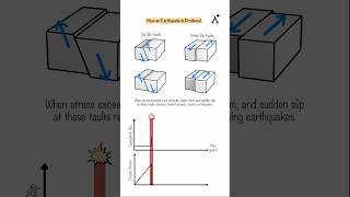
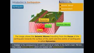
Tsunamigenic earthquakes, primarily associated with subduction zones, represent significant geological events where the vertical displacement of the seafloor during megathrust earthquakes can displace vast volumes of water. This displacement is a primary mechanism by which tsunamis are generated.
Key Points:
- Subduction Zones and Tsunamis: When one tectonic plate is forced under another, it can suddenly release energy, resulting in an earthquake. This vertical movement alters water levels, creating tsunamis.
- Tsunami Modeling: Accurate tsunami predictions require an understanding of tectonic plate interactions and an analysis of historical earthquake data, enabling researchers to model potential tsunami scenarios effectively.
- Early Warning Systems: The establishment of early warning systems, such as the Indian Tsunami Early Warning Centre, utilizes tectonic data to identify regions at risk of tsunami activity, helping to mitigate risk and prepare for potential disasters.
Youtube Videos


Audio Book
Dive deep into the subject with an immersive audiobook experience.
Subduction Zones and Tsunami Generation
Chapter 1 of 3
🔒 Unlock Audio Chapter
Sign up and enroll to access the full audio experience
Chapter Content
• Subduction Zones and Tsunamis: Vertical displacement of the seafloor during megathrust events displaces large water volumes.
Detailed Explanation
Subduction zones are areas where one tectonic plate is forced under another. This process can cause significant vertical displacement of the seafloor, which in turn can displace large volumes of water. When this displacement occurs suddenly, it can generate tsunamis, which are powerful ocean waves. These waves can travel across entire ocean basins and lead to devastating coastal impacts when they reach land.
Examples & Analogies
Think of subduction zones like a heavy piece of furniture placed on a soft rug. When you push down on the furniture, the rug underneath it compresses. When the furniture suddenly shifts or is lifted, the compressed rug stretches out, leading to a ripple effect that moves across the surface. Similarly, the sudden vertical movement of the Earth's crust in a subduction zone displaces water, creating a tsunami.
Tsunami Modeling
Chapter 2 of 3
🔒 Unlock Audio Chapter
Sign up and enroll to access the full audio experience
Chapter Content
• Tsunami Modeling: Relies heavily on tectonic plate boundary analysis and historical data.
Detailed Explanation
Tsunami modeling is a scientific process used to predict how a tsunami will behave once it has formed. This modeling takes into account the characteristics of tectonic plate boundaries—specifically where earthquakes are likely to occur. By analyzing historical data on past tsunamis and earthquakes, scientists can create models that help predict the wave height, speed, and potential impact of future tsunamis.
Examples & Analogies
Imagine you are baking a cake and need to estimate how long it will take to bake based on previous experiences. If you know how your oven typically works and how other cakes took to rise and brown, you can make a good estimation. Similarly, scientists use past data about previous tsunamis and the behavior of tectonic plates to predict the future impact of tsunami waves.
Early Warning Systems
Chapter 3 of 3
🔒 Unlock Audio Chapter
Sign up and enroll to access the full audio experience
Chapter Content
• Early Warning Systems: Use tectonic settings to identify potential tsunami zones (e.g., Indian Tsunami Early Warning Centre).
Detailed Explanation
Early warning systems are crucial for detecting tsunamis as they occur and for alerting communities at risk. These systems use information about tectonic settings—such as the locations of active subduction zones and historical tsunami data—to identify regions where tsunamis are more likely to occur. For instance, the Indian Tsunami Early Warning Centre monitors seismic activities and seismic waves to provide alerts ahead of a tsunami's arrival, giving communities valuable extra time to evacuate.
Examples & Analogies
Think of early warning systems like smoke detectors in your home. Just as smoke detectors use sensors to detect smoke or fire and alert you to evacuate, tsunami warning systems use seismic data to detect earthquakes that may lead to tsunamis and alert people in coastal areas to take necessary precautions before the waves hit.
Key Concepts
-
Subduction Zones: Areas where tectonic plates converge, resulting in earthquakes and potential tsunamis.
-
Tsunami Generation: Caused primarily by the vertical displacement of the ocean floor during megathrust events.
-
Tsunami Modeling: Using historical geological data to predict potential tsunami impacts.
-
Early Warning Systems: Essential for mitigating tsunami risks in affected communities.
Examples & Applications
The 2004 Indian Ocean earthquake is a notable example of a megathrust earthquake that caused devastating tsunamis due to seafloor displacement.
The Indian Tsunami Early Warning Centre uses tectonic and historical data to provide timely alerts for coastal populations at risk.
Memory Aids
Interactive tools to help you remember key concepts
Rhymes
When tectonic plates collide with force, watch the ocean's rise, of course!
Stories
Once upon a time, in a land beneath the sea, two tectonic friends had a quarrel so spree. As they pushed and shoved, the ground shook with might, causing waves to rise up and give coastal towns a fright.
Memory Tools
Remember 'S.U.B.' for Subduction: 'Seafloor Upwards, Big waves!'
Acronyms
'T.W.A.R,' stands for 'Tsunami Warning And Response,' to remember how communities prepare!
Flash Cards
Glossary
- Subduction Zone
A tectonic boundary where one plate slides beneath another, often causing earthquakes.
- Tsunamigenic Earthquake
An earthquake that generates a tsunami, particularly those occurring in subduction zones.
- Megathrust
A highly significant earthquake characterized by a large amount of vertical displacement in subduction zones.
- Tsunami Modeling
The process of simulating tsunamis based on geological and historical data to predict future tsunami events.
- Early Warning System
Technologies and protocols in place to detect and warn communities about potential tsunamis before they strike.
Reference links
Supplementary resources to enhance your learning experience.