
Modern Tools for Plate Tectonic Studies
Enroll to start learning
You’ve not yet enrolled in this course. Please enroll for free to listen to audio lessons, classroom podcasts and take practice test.
Interactive Audio Lesson
Listen to a student-teacher conversation explaining the topic in a relatable way.
GPS Tracking of Plate Movements
🔒 Unlock Audio Lesson
Sign up and enroll to listen to this audio lesson

Today, we're going to explore how GPS technology helps scientists track the movement of tectonic plates in real-time. Can anyone tell me what GPS stands for?

It stands for Global Positioning System!
Exactly! GPS uses satellites to pinpoint locations on Earth. By placing GPS stations along fault lines, we can detect the small movements of plates as they occur. This provides crucial data for understanding earthquake risks.

So, does that mean we can predict earthquakes better with GPS?
Not exactly predict, but it helps us monitor stress build-up along faults which can lead to earthquakes. Think of it as keeping an eye on a tight rubber band; when it's stretched too much, it may snap!

That's a good way to look at it! Are there other tools we use with GPS?
Yes, indeed! Tools like InSAR complement GPS by measuring ground deformation on a wider scale. Let's discuss that next!
InSAR and Its Applications
🔒 Unlock Audio Lesson
Sign up and enroll to listen to this audio lesson

InSAR stands for Interferometric Synthetic Aperture Radar. It uses satellite images to measure deformation of the Earth's surface. Student_4, do you know how it works?

I believe it uses radar waves to compare images taken at different times to see changes, right?
Exactly right! By comparing these images, we can detect even minute movements caused by tectonic shifts or seismic events. It's like a snapshot of the Earth's surface changing over time!
Can InSAR show us where earthquakes might happen?
While it doesn't predict earthquakes, it reveals where the ground is moving and how fast, which can highlight areas of concern for future seismic activity.
That sounds super useful for engineers, especially when building structures!
Absolutely! By knowing where and how much the ground is shifting, engineers can design structures that withstand seismic forces better.
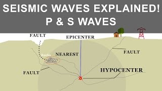
Seismographs and Their Importance
🔒 Unlock Audio Lesson
Sign up and enroll to listen to this audio lesson
Another critical tool in modern tectonic studies is the seismograph. What do you think a seismograph does, Student_3?
It measures earthquakes, right? Like how strong they are?
Exactly! Seismographs record the seismic waves generated by earthquakes, providing data on the event's strength and duration. This information is essential for calculating the earthquake's impact.
And that helps in making buildings safer, correct?
Right! By understanding the details of seismic waves, engineers can craft buildings that are capable of withstanding these forces, thus minimizing damage.
What about accelerometers?
Great question! Accelerometers measure how quickly the ground accelerates during an earthquake. This data, along with seismograph readings, gives a complete picture of an earthquake's effects.
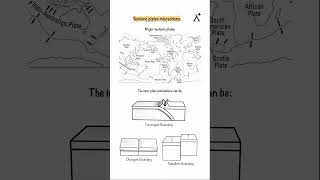
Geological Mapping and Remote Sensing
🔒 Unlock Audio Lesson
Sign up and enroll to listen to this audio lesson
Now let's discuss geological mapping and remote sensing. How do you think these techniques help us in understanding tectonics, Student_2?
They probably help identify where faults are and show what kind of geological features are in an area.
Spot on! Geological maps provide a visual representation of different rock types and fault lines, while remote sensing allows us to analyze these from above using satellite imagery.
So, this means we can see changes in the Earth over large areas without going there?
Exactly! This is crucial for assessing seismic risks and planning for infrastructure development. Remember, understanding the ground geology helps in making safer engineering decisions.
That’s very practical! It must help a lot in construction projects.
Yes! Accurate geological mappings combined with other technologies create a robust framework for designing earthquake-resilient structures.
Introduction & Overview
Read summaries of the section's main ideas at different levels of detail.
Quick Overview
Standard
The section discusses how contemporary technologies such as GPS and InSAR are used for real-time monitoring of plate movements, while seismographs measure seismic waveforms for better understanding of tectonic activity. Geological mapping and remote sensing offer additional insights for fault identification and structural assessment, enhancing our knowledge of tectonic processes.
Detailed
Detailed Summary
The study of plate tectonics has evolved significantly with the advent of modern technology. This section highlights the tools used for understanding the dynamics of Earth's tectonic plates and the implications for earthquake monitoring and geological research.
Key Tools and Technologies
- GPS (Global Positioning System): Utilized for tracking the movements of tectonic plates in real-time, providing precise data on plate positions and shifts.
- InSAR (Interferometric Synthetic Aperture Radar): A satellite technology that measures ground deformation caused by tectonic movements, allowing us to visualize the displacement of the Earth’s surface.
- Seismographs: Essential for measuring seismic waveforms, they help in analyzing earthquake events and understanding their intensity and impact.
- Accelerometers: Devices that detect ground acceleration during seismic events, contributing to the study of earthquake forces.
- Geological Mapping and Remote Sensing: Techniques used for fault identification and structural assessments, facilitating a better understanding of tectonic interactions.
These tools and technologies are crucial for advancing our knowledge of plate tectonics, seismic activity, and the associated engineering applications in earthquake risk mitigation.
Youtube Videos


Audio Book
Dive deep into the subject with an immersive audiobook experience.
GPS and InSAR Technology
Chapter 1 of 3
🔒 Unlock Audio Chapter
Sign up and enroll to access the full audio experience
Chapter Content
• GPS and InSAR (Satellite Technology): Track plate movement in real-time.
Detailed Explanation
Global Positioning System (GPS) and Interferometric Synthetic Aperture Radar (InSAR) are modern satellite technologies used to monitor the movements of tectonic plates. GPS uses a network of satellites to determine precise locations on Earth, allowing scientists to measure how much the plates shift over time. InSAR, on the other hand, uses radar images from satellites to identify ground displacements. Together, these tools provide real-time data on the dynamic movements of the Earth's crust, which is crucial for understanding plate tectonics.
Examples & Analogies
Imagine a magician’s trick where he spreads cards across a large table. By using GPS and InSAR, scientists are like a camera zooming in on this table to see how the cards (tectonic plates) shift in position over time. If one corner of the table is lifted slightly (like an earthquake), the camera captures this movement as it happens, allowing the magician (scientists) to analyze and understand the magic (the movements of the plates) behind the trick.
Seismographs and Accelerometers
Chapter 2 of 3
🔒 Unlock Audio Chapter
Sign up and enroll to access the full audio experience
Chapter Content
• Seismographs and Accelerometers: Measure seismic waveforms.
Detailed Explanation
Seismographs are instruments that record the seismic waves produced by earthquakes. When an earthquake occurs, it generates vibrations that travel through the Earth; seismographs detect these waves and create a graphical representation of the shaking intensity and duration. Accelerometers are similar but specifically measure the acceleration of ground motion. Together, they help scientists assess the strength of an earthquake and monitor additional seismic activity, aiding in earthquake preparedness and risk assessment.
Examples & Analogies
Think of a seismograph as a sensitive microphone capturing the sounds of a rock concert. Just like the microphone picks up the sound waves and translates them into an audio recording, seismographs capture seismic waves and create a record of the earthquake, allowing us to analyze its effects. Accelerometers are like volume meters, telling us how loudly the music (shaking) is playing, which helps us understand the intensity of the earthquakes.
Geological Mapping and Remote Sensing
Chapter 3 of 3
🔒 Unlock Audio Chapter
Sign up and enroll to access the full audio experience
Chapter Content
• Geological Mapping and Remote Sensing: For fault identification and structural assessments.
Detailed Explanation
Geological mapping involves creating detailed visual representations of Earth's surface and subsurface geology, which helps identify faults, rock types, and other crucial geological features. Remote sensing utilizes satellite imagery and aerial photography to study features of the Earth's surface without direct contact. These methods provide valuable insights into fault lines and geological structures, improving our understanding of tectonic activities and potential hazards.
Examples & Analogies
Imagine a treasure map where X marks the spot of hidden gems. Geological mapping is like that map; it helps scientists pinpoint locations of faults and features in the Earth. Remote sensing is like using a drone that can fly over the area, giving a bird's-eye view without having to dig in the dirt. Together, they provide the clues needed to understand where treasure (geological hazards) can hide beneath the surface.
Key Concepts
-
GPS: A technology for real-time tracking of tectonic plate movements.
-
InSAR: A satellite technique that measures ground deformation.
-
Seismographs: Instruments that record seismic activity and assess earthquake strength.
-
Geological Mapping: A method used to identify geological features and fault lines.
Examples & Applications
In California, GPS stations track the San Andreas Fault movement, providing data for earthquake preparedness.
InSAR has been used to detect ground deformation in regions like Indonesia, aiding in disaster planning.
Memory Aids
Interactive tools to help you remember key concepts
Rhymes
GPS tracks movements with grace, InSAR shows changes in space.
Stories
Imagine satellites high above, watching the Earth like a protective dove, measuring shifts both big and small, ensuring we’re ready when quakes might call.
Acronyms
G-reat P-redictor for S-eismic movements - GPS!
I-nterferometric S-ensing A-llows R-eal-time monitoring - InSAR!
Flash Cards
Glossary
- GPS
Global Positioning System, a satellite-based navigation system that enables precise location tracking.
- InSAR
Interferometric Synthetic Aperture Radar, a satellite technique used to detect ground deformation.
- Seismograph
An instrument for measuring and recording the motions of seismic waves from earthquakes.
- Accelerometer
A device that measures the acceleration of ground motion during an earthquake.
- Geological Mapping
The process of creating maps that show the distribution of various geological features.
- Remote Sensing
The use of satellite or aerial imagery to gather information about the Earth's surface.
Reference links
Supplementary resources to enhance your learning experience.