
Real-Time Error Correction in GNSS
Enroll to start learning
You’ve not yet enrolled in this course. Please enroll for free to listen to audio lessons, classroom podcasts and take practice test.
Interactive Audio Lesson
Listen to a student-teacher conversation explaining the topic in a relatable way.
Introduction to GNSS Errors
🔒 Unlock Audio Lesson
Sign up and enroll to listen to this audio lesson

Today, we're going to discuss Global Navigation Satellite Systems, known as GNSS. Can anyone tell me why we need to correct errors in GNSS data?

To improve accuracy, right?
Exactly, Student_1! GNSS errors can arise from issues like satellite clock errors and atmospheric delays. These inaccuracies can significantly affect our positioning. Now, who can explain what Differential GNSS, or DGNSS, does?

It uses reference stations to send corrections to the receivers.
Great! DGNSS provides real-time corrections by leveraging a network of stationary reference stations, which helps improve our accuracy significantly. Remember the acronym 'DGNSS' for ‘Differential GNSS’ to retain the concept!

So, it's like having a teacher helping you correct your homework?
That's a perfect analogy! Let’s move to the next technique: Real-Time Kinematic, or RTK. What do you think is special about RTK?
Real-Time Kinematic (RTK)
🔒 Unlock Audio Lesson
Sign up and enroll to listen to this audio lesson

RTK provides centimeter-level accuracy using carrier-phase measurements. Can someone explain how this works?

I think it's similar to DGNSS but more accurate because it uses a base station.
Correct, Student_4! RTK relies on a base station that sends correction signals to the mobile receiver. This method is critical for applications where high precision is required, such as in surveying and autonomous vehicles. Can anyone think of a real-world example where this might be used?
Maybe when mapping a new construction site?
Absolutely! In construction, precise measurements are essential to ensure that structures are built correctly. Let’s summarize what we've learned: RTK boosts accuracy by using real-time corrections from a base station.
Precise Point Positioning (PPP)
🔒 Unlock Audio Lesson
Sign up and enroll to listen to this audio lesson
Now, let's discuss Precise Point Positioning, or PPP. Who can explain what makes PPP different from the other methods we've discussed?
PPP doesn’t require a base station, right?
Exactly! It uses satellite data corrections to address systematic errors, allowing flexibility in usage. Can anyone think of situations where that might be beneficial?
Like when you're in a remote area without a base station?
Precisely! In remote locations, PPP is incredibly valuable because it still offers corrections without relying on nearby stations. Does anyone remember a key takeaway from our discussion today?
Real-time error correction is crucial for applications needing high accuracy!
Well done, everyone! Understanding these methods advances our ability to work with GNSS data more effectively.
Introduction & Overview
Read summaries of the section's main ideas at different levels of detail.
Quick Overview
Standard
Real-time error correction in GNSS is crucial for improving positional accuracy, especially for applications requiring high precision. Key techniques include Differential GNSS (DGNSS), Real-Time Kinematic (RTK), and Precise Point Positioning (PPP), each offering unique advantages depending on the requirements of the survey or navigation task.
Detailed
Real-Time Error Correction in GNSS
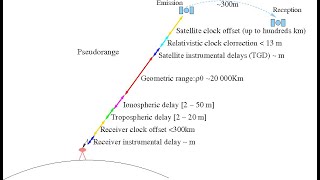
Global Navigation Satellite Systems (GNSS) like GPS, GLONASS, Galileo, and NavIC are integral to geospatial measurements, yet they are susceptible to several errors including satellite clock discrepancies, atmospheric delays (ionospheric and tropospheric), and multipath errors. This section focuses on how these inaccuracies can be mitigated through real-time correction methods:
1. Differential GNSS (DGNSS)
DGNSS enhances GNSS accuracy by utilizing a network of stationary reference stations that receive satellite signals and identify errors. These reference stations transmit correction data in real-time to GNSS receivers, significantly improving their positioning accuracy.
2. Real-Time Kinematic (RTK)
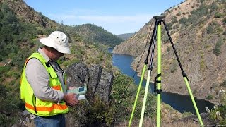
RTK technology takes this a step further by employing carrier-phase measurements. It achieves centimeter-level accuracy through the use of a base station that sends corrections to a mobile receiver. RTK is especially vital in applications like surveying and autonomous navigation where precision is critical.
3. Precise Point Positioning (PPP)
PPP techniques provide corrective measures based on correction services without the necessity of a local base station. This method relies on satellite data corrections to eliminate systematic and random GNSS errors, offering flexibility in applications such as high-precision mapping and UAV-based surveying.
These real-time error correction strategies are essential for ensuring reliable and accurate GNSS data in various high-precision applications, ultimately enhancing the integrity of geospatial data collection.
Youtube Videos


Audio Book
Dive deep into the subject with an immersive audiobook experience.
Introduction to GNSS Errors
Chapter 1 of 5
🔒 Unlock Audio Chapter
Sign up and enroll to access the full audio experience
Chapter Content
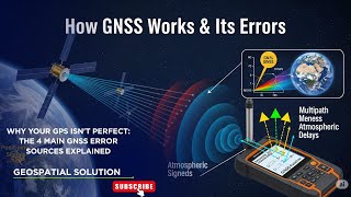
Global Navigation Satellite Systems (GNSS) like GPS, GLONASS, Galileo, and NavIC are prone to multiple sources of error such as:
- Satellite clock error.
- Ionospheric and tropospheric delay.
- Multipath error.
Detailed Explanation
Global Navigation Satellite Systems (GNSS) are technologies that help users determine their precise location on Earth using signals from satellites. However, these systems can frequently encounter errors that reduce accuracy. Three main sources of error include:
1. Satellite Clock Error: This occurs when the satellite's internal clock is slightly off, which can lead to incorrect distance calculations.
2. Ionospheric and Tropospheric Delay: These layers of the atmosphere can slow down the signals from satellites, causing accuracy issues.
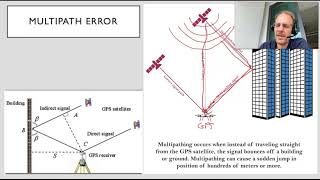
3. Multipath Error: This happens when signals bounce off surfaces (like buildings or mountains) before reaching the receiver, leading to confusion in determining the correct position.
Examples & Analogies
Imagine you are trying to use a flashlight in a foggy environment. The light (satellite signals) can get distorted and might not lead you directly to your destination (your location). Just as the fog makes it harder to see, these errors make it more difficult for GNSS systems to deliver precise data.
Differential GNSS (DGNSS)
Chapter 2 of 5
🔒 Unlock Audio Chapter
Sign up and enroll to access the full audio experience
Chapter Content
DGNSS enhances accuracy by using a network of reference stations that provide real-time correction data to receivers.
Detailed Explanation
Differential GNSS (DGNSS) is an improvement over standard GNSS, as it uses a network of fixed reference stations located at known positions. These stations continuously monitor the satellite signals and calculate any errors resulting from the satellite's position or atmospheric conditions. When a user’s GNSS receiver is nearby one of these stations, it receives correction data in real-time, which helps to significantly enhance accuracy. This method is especially useful in applications that require high precision, such as surveying or navigation.
Examples & Analogies
Think of DGNSS like having a friend who knows the shortcuts and can guide you while you're using GPS in an unfamiliar city. Your friend (reference station) spots when your GPS instructions might be misleading and tells you how to adjust your route for a smoother journey. That way, you can arrive at your destination with minimal errors.
Real-Time Kinematic (RTK)
Chapter 3 of 5
🔒 Unlock Audio Chapter
Sign up and enroll to access the full audio experience
Chapter Content
RTK uses carrier-phase measurements and provides centimeter-level accuracy using a base station and a mobile receiver.
Detailed Explanation
Real-Time Kinematic (RTK) positioning is a technique used to improve the precision of GNSS by utilizing carrier-phase measurements which are more accurate than standard GNSS position calculations. In RTK, a base station is set at a known, fixed location. This station measures the satellite signals and transmits correction information to a mobile GNSS receiver in real-time. This method can achieve centimeter-level accuracy and is commonly applied in tasks like autonomous robotics and high-precision agriculture.
Examples & Analogies
Imagine a teacher (base station) who is helping students (mobile receivers) solve math problems (positioning) by providing them with the exact answers while they work on their exercises. This support from the teacher allows students to achieve very accurate solutions (centimeter-level accuracy) compared to just relying on their own calculations.
Precise Point Positioning (PPP)
Chapter 4 of 5
🔒 Unlock Audio Chapter
Sign up and enroll to access the full audio experience
Chapter Content
PPP techniques remove systematic and random GNSS errors using correction services without needing a local base station.
Detailed Explanation
Precise Point Positioning (PPP) is a method used to improve GNSS positioning accuracy without the need for local reference stations. It uses correction services that account for all known variables affecting GNSS signals, such as satellite orbit determination and atmospheric effects. By applying corrections to both systematic and random errors, PPP can achieve high accuracy for users located anywhere, although typically not as high as RTK solutions. This is particularly useful for applications that require mobility, like mobile surveying or personal navigation.
Examples & Analogies
PPP is like using a reliable online calculator instead of asking for help from a neighbor. Regardless of where you are, as long as you have access to the internet (the correction service), you can input your calculations and get accurate results without needing to rely on someone physically close by.
Applications of Real-Time Error Correction
Chapter 5 of 5
🔒 Unlock Audio Chapter
Sign up and enroll to access the full audio experience
Chapter Content
These methods are essential in applications like UAV-based surveying, autonomous navigation, and high-precision mapping.
Detailed Explanation
Real-time error correction methods in GNSS are essential for various advanced applications. For example:
1. UAV-based Surveying: Drones equipped with GNSS technology rely on these corrections to capture high-precision geo-referenced images and data for surveying purposes.
2. Autonomous Navigation: Self-driving cars use RTK or DGNSS for accurate positioning to navigate safely through their environment.
3. High-Precision Mapping: PPP techniques allow for accurate mapping of features in various industries, including agriculture and urban planning, ensuring that spatial data remains reliable and precise.
Examples & Analogies
Consider a film crew using GPS-equipped drones to capture a movie scene from above. The high-quality pictures and accurate data collected depend on real-time corrections to ensure the drones fly exactly where they need to, avoiding obstacles and capturing the right angles. Just like the film crew needs precise positioning to avoid errors, various applications depend on GNSS corrections for accuracy.
Key Concepts
-
GNSS Accuracy: Refers to how close a GNSS measurement is to the true position.
-
DGNSS: A method that improves GNSS accuracy using stationary reference stations for real-time corrections.
-
RTK: A technique that provides high-precision positioning by utilizing a base station and carrier-phase measurements.
-
PPP: A method that allows for GNSS correction without the need for a local base station.
Examples & Applications
Using DGNSS for surveying to enhance positional accuracy in land mapping.
Employing RTK in autonomous vehicles for precise navigation in urban environments.
Applying PPP for remote sensing applications in locations without immediate access to base stations.
Memory Aids
Interactive tools to help you remember key concepts
Rhymes
RTK brings you near, with precision that's clear. DGNSS helps with a steady cheer, while PPP travels far without fear.
Stories
Imagine a mapmaker named Denny who always carried a special GPS. In the cities, he used DGNSS for crisp clarity, while hiking in the mountains, he relied on PPP to navigate without needing a tower.
Memory Tools
Remember: DGNSS for Data help, RTK for Real-Time Kicks, and PPP for Precision, Presently-Proven.
Acronyms
DGNSS - Differential GNSS; RTK - Real-Time Kinematic; PPP - Precise Point Positioning
Flash Cards
Glossary
- Global Navigation Satellite Systems (GNSS)
Satellite systems used for determining precise location anywhere on Earth, such as GPS and GLONASS.
- Differential GNSS (DGNSS)
A method that enhances GNSS accuracy using a network of reference stations to provide real-time correction data.
- RealTime Kinematic (RTK)
A technique that uses carrier-phase measurements to achieve centimeter-level positioning accuracy.
- Precise Point Positioning (PPP)
A method of correcting GNSS errors using satellite data services without the need for local base stations.
Reference links
Supplementary resources to enhance your learning experience.