
Sources of Errors in Geo-Informatics
Enroll to start learning
You’ve not yet enrolled in this course. Please enroll for free to listen to audio lessons, classroom podcasts and take practice test.
Interactive Audio Lesson
Listen to a student-teacher conversation explaining the topic in a relatable way.
Data Acquisition Errors
🔒 Unlock Audio Lesson
Sign up and enroll to listen to this audio lesson

Today we're diving into Data Acquisition Errors. Can anyone tell me what happens during GPS signal multipath interference?

Is that when the GPS signals bounce off buildings?
Exactly! This bounce can cause the GPS to calculate incorrect locations. This highlights how environmental factors can impact data quality. Now, can anyone think of other sources of data acquisition errors?

What about satellite image distortions?
Good thought! Geometric distortions can greatly affect how we interpret satellite images. We need to ensure that we correct for these inaccuracies. Let’s move to errors in remote sensing sensors. What do you think are some limitations?

I remember reading about how atmospheric conditions can affect sensor readings.
Correct! Environmental conditions play a crucial role. Remember the acronym 'GSD' for Ground Sampling Distance; it can help you keep in mind the relation between spatial resolution and data quality.
To summarize, Data Acquisition Errors stem from GPS interference, image distortions, and sensor limitations, all of which call for careful management to maintain data integrity.
Data Processing Errors
🔒 Unlock Audio Lesson
Sign up and enroll to listen to this audio lesson

Now, let’s talk about Data Processing Errors. How does incorrect transformation parameters create issues?

If we don’t convert coordinates properly, the location can end up being wrong, right?
Exactly! This can cause severe inaccuracies in spatial datasets. What about interpolation techniques? Can someone explain what happens if they’re inaccurate?
It could lead to incorrect estimates at unmeasured locations.
Right! Improper interpolation can distort the underlying data pattern. So, what can we do to minimize these errors during processing?
I think using automated methods would help reduce human errors in digitizing.
Excellent point! Automation plays a vital role. Let’s summarize: Data Processing Errors include incorrect transformations, inaccuracies in interpolation, and issues with digitization, all needing corrective measures.
Data Integration Errors
🔒 Unlock Audio Lesson
Sign up and enroll to listen to this audio lesson
Finally, let’s explore Data Integration Errors. What kinds of mismatches can occur when integrating datasets?
Different scales and projections can create inconsistencies.
Absolutely! This makes it challenging to compare and analyze the data. What about temporal inconsistencies?
Data collected at different times may not represent the same context.
Exactly! We must ensure temporal alignment. Lastly, what about data formats?
Incompatible formats mean we can’t merge data sets effectively.
Spot on! To wrap up today's discussion, Data Integration Errors arise from mismatched scales, temporal inconsistencies, and incompatible formats—key factors that impede the integration process.
Introduction & Overview
Read summaries of the section's main ideas at different levels of detail.
Quick Overview
Standard
Errors in Geo-Informatics stem from multiple stages of data handling. Key sources include data acquisition errors such as GPS signal multipath interference, processing errors like incorrect transformation parameters, and integration errors due to mismatched scales or projections. A thorough understanding of these errors is critical to improve data quality and reliability.
Detailed
Sources of Errors in Geo-Informatics
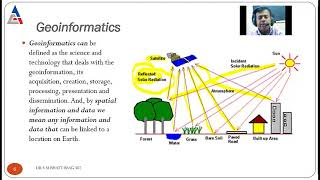
In Geo-Informatics, ensuring the accuracy and reliability of data is essential. However, various sources of errors can undermine data integrity, and these errors can be categorized into three main stages:
1. Data Acquisition Errors
These errors occur during the initial collection of data and may include:
- GPS signal multipath interference: This happens when GPS signals bounce off surfaces like buildings or trees, leading to inaccurate location data.
- Satellite image geometric distortions: These distortions arise from the satellite’s perspective, affecting the accuracy of geospatial information.
- Remote sensing sensor limitations: Factors like sensor precision, calibration, and environmental conditions can lead to variations in data quality.
2. Data Processing Errors
After data has been collected, processing involves transformations that can introduce errors if not done correctly:
- Incorrect transformation parameters: Errors during coordinate conversion can lead to spatial inaccuracies.
- Inaccurate interpolation techniques: When estimating values at unmeasured locations, poor methods can produce misleading results.
- Digitizing errors: Manual tracing of data can lead to mistakes, especially if complex features are involved.
3. Data Integration Errors
Integrating data from various sources poses additional challenges, such as:
- Mismatch of scales and projections: Different datasets may use varying scales, leading to discrepancies when combined.
- Temporal inconsistency: Data collected at different times may not accurately represent the same phenomena, complicating analysis.
- Incompatibility of data formats or coordinate systems: Different formats can hinder the seamless integration of diverse datasets.
Understanding these sources of errors is critical for researchers and practitioners in Geo-Informatics to apply proper methods for error minimization and ensure data integrity.
Youtube Videos


![What is MSc Geoinformatics course? – [Hindi] – Quick Support](https://img.youtube.com/vi/QC6cEfNk1aQ/mqdefault.jpg)


Audio Book
Dive deep into the subject with an immersive audiobook experience.
Data Acquisition Errors
Chapter 1 of 3
🔒 Unlock Audio Chapter
Sign up and enroll to access the full audio experience
Chapter Content
- GPS signal multipath interference.
- Satellite image geometric distortions.
- Remote sensing sensor limitations.
Detailed Explanation
Data acquisition errors occur during the initial data gathering phase. These can arise from issues like multipath interference, where GPS signals bounce off buildings or other obstacles, causing inaccuracies. Satellite images may also suffer from geometric distortions due to the angle of capture or sensor inaccuracies. Additionally, limitations in remote sensing sensors themselves can lead to data quality issues. Each of these errors affects the reliability of the data collected, making it essential to identify and reduce them during the data acquisition process to ensure the integrity of geospatial information.
Examples & Analogies
Imagine trying to listen to a radio station, but there are buildings and trees in the way causing interruptions. This is similar to GPS signal multipath interference. Just as it’s hard to enjoy a clear broadcast, data collection can be disrupted by physical obstacles, leading to mixed signals and imprecise geographic data.
Data Processing Errors
Chapter 2 of 3
🔒 Unlock Audio Chapter
Sign up and enroll to access the full audio experience
Chapter Content
- Incorrect transformation parameters during coordinate conversion.
- Inaccurate interpolation techniques.
- Digitizing errors from manual tracing.
Detailed Explanation
Data processing errors arise after data has been collected, when it is transformed, analyzed, or manipulated. Incorrect transformation parameters can lead to inaccurate geographic coordinates, potentially shifting a location significantly. Interpolation techniques, which estimate unknown values from known data points, can also introduce errors if not done correctly. Lastly, manual digitizing—turning paper maps into digital format by tracing—can introduce errors if the person tracing makes mistakes. Understanding these errors is crucial for ensuring processed data remains accurate.
Examples & Analogies
Think about baking a cake. If you mismeasure sugar or incorrectly interpret the conversion from cups to grams, your cake won't turn out as expected. Similarly, if the parameters for processing geographic data aren’t accurate or if the digitizing is done inaccurately, the resulting data won't be reliable.
Data Integration Errors
Chapter 3 of 3
🔒 Unlock Audio Chapter
Sign up and enroll to access the full audio experience
Chapter Content
- Mismatch of scales and projections.
- Temporal inconsistency in datasets.
- Incompatibility of data formats or coordinate systems.
Detailed Explanation
Data integration errors occur when combining different datasets. A mismatch of scales and projections can lead to confusion in representing spatial features accurately—think one map showing a city in zoom view while another shows the same area far away. Temporal inconsistencies can arise when datasets are collected at different times, making comparisons invalid. Additionally, if datasets are in different formats or coordinate systems, it can complicate their integration, leading to further errors. Ensuring uniformity across files is key to a cohesive geospatial analysis.
Examples & Analogies
Consider trying to fit pieces of a puzzle that are not from the same set. The pieces may look similar at first glance, but they won’t connect properly if they are from different sets or if they are from different times when the designs changed. In the same way, integrating datasets without aligning their formats, timelines, or projections can result in confusion and inaccuracies.
Key Concepts
-
Data Acquisition: The initial stage of collecting data which can have various sources of error.
-
Data Processing: The manipulation stage where inaccuracies can arise due to incorrect methods.
-
Data Integration: The final stage of bringing together different datasets that can lead to potential errors.
Examples & Applications
An example of data acquisition errors can be seen when a GPS device receives signals from reflective surfaces, leading to inaccurate position readings.
One might experience processing errors when using wrong parameters in transformation algorithms, resulting in misaligned data.
Memory Aids
Interactive tools to help you remember key concepts
Rhymes
In acquisition, signals can stray, causing troubles in data play.
Stories
Imagine a GPS on a clear day, suddenly distorted by reflections, leading it astray from true data.
Memory Tools
Remember ARMED for errors: Acquisition, Recording, Manipulation, and Design—key sources in errors.
Acronyms
DIME
Data Integration Mismatches Errors
representing issues in data integration processes.
Flash Cards
Glossary
- Data Acquisition Errors
Errors that occur during the initial collection of data, often due to external factors like GPS signal interference or sensor limitations.
- Data Processing Errors
Mistakes made during the manipulation and transformation of data, leading to inaccurate outputs.
- Data Integration Errors
Challenges faced when merging different datasets, often due to scale mismatches, temporal inconsistencies, or format incompatibilities.
Reference links
Supplementary resources to enhance your learning experience.