
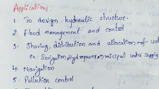
Applications in Engineering
Enroll to start learning
You’ve not yet enrolled in this course. Please enroll for free to listen to audio lessons, classroom podcasts and take practice test.
Interactive Audio Lesson
Listen to a student-teacher conversation explaining the topic in a relatable way.
Design of Hydraulic Structures
🔒 Unlock Audio Lesson
Sign up and enroll to listen to this audio lesson

Today, we will discuss how hydrological data informs the design of hydraulic structures such as dams, reservoirs, and spillways. Can someone tell me why hydrology is important for these designs?

I think it's because we need to know how much water flows into these structures.
Correct! We use data to determine things like design flood levels and reservoir capacity. For example, we calculate the 'Probable Maximum Flood' or PMF. Can anyone explain what PMF means?

It represents the highest flood that could theoretically occur.
Exactly! That's crucial for ensuring the safety of these structures. Now, can anyone think of how sedimentation might impact a reservoir?

Sedimentation could reduce its capacity and lifespan.
Absolutely right! That's why sedimentation studies are integral to design. To summarize, hydraulic designs utilize hydrological data to ensure that structures are safe, effective, and long-lasting.
Flood Estimation and Management
🔒 Unlock Audio Lesson
Sign up and enroll to listen to this audio lesson

Let's shift our focus to flood estimation and management. Can anyone name some methods we use to estimate design flood?

There's the Unit Hydrograph Method and the Rational Method.
Great examples! The SCS-CN method is also widely used. How do you think these methods help in flood control?
They help engineers predict flood levels and design systems accordingly.
Exactly! Accurate predictions help us build effective flood control measures. What about floodplain mapping? Who can explain its importance?
It helps identify flood-prone areas for better urban planning.
Well summarized! Finally, let’s remember that effective flood management combines structural and non-structural measures. To wrap up, methods like GIS help us delineate flood risks effectively.
Urban Hydrology and Groundwater Engineering
🔒 Unlock Audio Lesson
Sign up and enroll to listen to this audio lesson
Now let’s discuss urban hydrology! How does urbanization impact water management?
Urbanization increases impervious surfaces, leading to more runoff.
Exactly! Students, what solutions can we implement to manage stormwater in urban areas?
We can use Sustainable Urban Drainage Systems, like bioswales and permeable pavements.
Absolutely! These solutions help mitigate runoff and promote groundwater recharge. Speaking of recharge, can someone share the benefits of groundwater engineering?
It helps us sustainably use water resources. Techniques like artificial recharge can replenish aquifers.
Correct! Groundwater management is vital for sustainable resource allocation. In conclusion, urbanization requires innovative strategies to balance water flow and ensure adequate groundwater supplies.
Watershed Management and Climate Change
🔒 Unlock Audio Lesson
Sign up and enroll to listen to this audio lesson
Let's delve into watershed management. Why is delineating a watershed essential for effective management?
It allows us to assess runoff and implement conservation measures within the area.
Exactly! Techniques such as contour bunding and terracing control erosion and sedimentation. How do climate changes factor into hydrological applications?
They can change rainfall patterns and increase extreme weather events, affecting water resources.
Correct! Climate-resilient infrastructure designs are essential. Students, how could adaptive design strategies play a role?
They help engineers prepare for varying conditions like flexible spillway sizing.
Exactly! Stakeholder participation and integrated management are key to sustainable water resource management. Overall, understanding watershed dynamics and climate impacts is critical for effective engineering.
Introduction & Overview
Read summaries of the section's main ideas at different levels of detail.
Quick Overview
Standard
Hydrology plays a crucial role in engineering, assisting in the design of hydraulic structures and flood management systems. The knowledge of water movement, quality, and quantity is applied in various sectors, encompassing dam design, urban hydrology, flood estimation, and groundwater management.
Detailed
Applications in Engineering
Hydrology, the study of the movement, distribution, and quality of water, is essential in civil engineering applications. This chapter details how hydrological principles are utilized in designing and managing hydraulic infrastructures like dams, reservoirs, flood control measures, and groundwater systems.
Key Points:
- Design of Hydraulic Structures: Effective design relies on hydrological data for structures like dams, spillways, and canals.
- Flood Estimation and Management: Methods are utilized to estimate design floods and manage flooding through techniques like GIS mapping and zoning.
- Urban Hydrology: Focuses on the impact of urbanization on water runoff and the design of drainage systems in urban areas.
- Groundwater Engineering Applications: Involves methods for groundwater extraction, recharge strategies, and sustainable resource management.
- Watershed Management: Integrates modeling, runoff, and soil conservation techniques for effective watershed management.
- Hydrological Modeling Tools: Utilizes various modeling tools combining empirical data and remote sensing for effective analysis.
- Climate Change Adaptation: Addresses the impact of climate change on hydrological practices and the importance of designing climate-resilient infrastructure.
Understanding these applications is crucial for developing sustainable and resilient engineering solutions.
Youtube Videos

![Introduction to Engineering Hydrology and its Applications [Year - 3]](https://img.youtube.com/vi/Sds3dB-hA8E/mqdefault.jpg)

Audio Book
Dive deep into the subject with an immersive audiobook experience.
Introduction to Hydrology in Engineering
Chapter 1 of 8
🔒 Unlock Audio Chapter
Sign up and enroll to access the full audio experience
Chapter Content
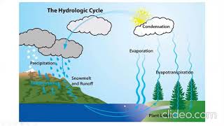
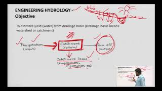
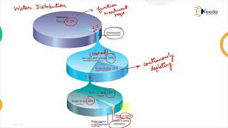
Hydrology, as a scientific and applied discipline, is indispensable in the planning, design, and management of various civil engineering projects. The knowledge of water movement, distribution, and quality over the Earth’s surface is used extensively in engineering applications—ranging from the design of hydraulic structures to watershed management, flood forecasting, and groundwater extraction.
Detailed Explanation
Hydrology is a branch of science that studies water — its movement across the earth's surface, its distribution, and its quality. In civil engineering, hydrology is crucial for effective planning and management of projects. For instance, understanding how water flows helps engineers design dams and manage water supplies. By analyzing data on rainfall and surface water, engineers can also predict floods and efficiently extract groundwater.
Examples & Analogies
Think of hydrology like monitoring a huge plumbing system. Just like a plumber needs to know where the pipes are, how they connect, and where water flows, engineers need to understand water paths in nature to design safe buildings, roads, and dams.
Design of Hydraulic Structures
Chapter 2 of 8
🔒 Unlock Audio Chapter
Sign up and enroll to access the full audio experience
Chapter Content
Hydrological data is vital in designing various hydraulic structures like:
1. Dams and Reservoirs
- Determination of design flood using frequency analysis and rainfall-runoff modeling.
- Estimation of reservoir capacity based on inflow-outflow analysis and dependable yield.
- Incorporation of safety criteria (e.g., PMF - Probable Maximum Flood and SPF - Standard Project Flood).
- Sedimentation studies and impact on reservoir life.
2. Spillways and Energy Dissipators
- Hydrologic routing of flood through reservoir.
- Estimating peak discharge for spillway design.
- Energy dissipation using stilling basins, hydraulic jumps, and bucket-type spillways.
3. Canals and Headworks
- Designing cross-sections based on flow duration curves.
- Ensuring minimum ecological flow in irrigation canals.
- Integration of scour depth, silt transport, and bed load estimation in canal intakes.
Detailed Explanation
This chunk outlines the importance of hydrological data in the design of key hydraulic structures. For dams and reservoirs, engineers need to calculate potential flood scenarios to ensure safety and capacity. They conduct analyses to determine how much water the reservoir can hold amidst changing conditions. Similarly, for spillways, understanding flood routing helps engineers design structures that manage floodwaters effectively. In canals, engineers also consider environmental impacts, ensuring water flow meets ecological needs, as well as optimizing designs based on observed water behaviors.
Examples & Analogies
Imagine building a large swimming pool. Just as you have to calculate how many gallons of water it can hold and how it will behave when lots of people jump in, engineers must do similar calculations for dams and reservoirs to make sure they can handle lots of water during a storm.
Flood Estimation and Management
Chapter 3 of 8
🔒 Unlock Audio Chapter
Sign up and enroll to access the full audio experience
Chapter Content
In flood estimation and management, several methods are utilized:
1. Design Flood Estimation
- Application of Unit Hydrograph Method and Synthetic Hydrographs.
- Use of Rational Method, SCS-CN method, and HEC-HMS in urban and rural settings.
2. Flood Routing
- Hydrologic routing (e.g., Muskingum Method).
- Hydraulic routing using Saint-Venant equations.
- Flood routing through channels and reservoirs to estimate peak attenuation and lag time.
3. Floodplain Mapping and Zoning
- GIS and Remote Sensing-based delineation of flood-prone areas.
- Application in urban planning and infrastructure development.
- Use of FEMA (USA) standards or CWC (India) guidelines for zoning.
4. Flood Control Measures
- Structural: levees, embankments, retention basins, diversion channels.
- Non-structural: flood forecasting, warning systems, community preparedness.
Detailed Explanation
Flood estimation and management involve several advanced techniques. Engineers use methods to determine the likely maximum flood levels. Tools like GIS help map areas at risk for flooding to aid in urban planning. Using structural measures such as levees can help protect against floods, while non-structural measures like forecasting allow communities to prepare and respond quickly. Understanding these elements helps engineers minimize the impact of floods on society.
Examples & Analogies
Think about a neighborhood that often floods during heavy rains. By studying rainfall data and creating maps, planners can determine which areas are at risk and install barriers like levees to protect homes. Just like a flood alert system could warn residents to seek higher ground during storms, engineers create structures and systems to keep people safe.
Urban Hydrology
Chapter 4 of 8
🔒 Unlock Audio Chapter
Sign up and enroll to access the full audio experience
Chapter Content
Urban hydrology focuses on the management of water in urbanized areas:
1. Impact of Urbanization
- Reduced infiltration and increased surface runoff.
- Runoff coefficient changes due to impervious surfaces.
2. Design of Urban Drainage Systems
- Estimation of peak discharge using Rational Method.
- Stormwater management: detention and retention ponds.
- Sustainable Urban Drainage Systems (SUDS) including bioswales, permeable pavements, green roofs.
Detailed Explanation
In urban areas, the surfaces are often paved, which prevents water from soaking into the ground, leading to increased runoff. This can cause flooding. Urban hydrology aims to manage this water through drainage systems that collect and redirect stormwater. Systems like detention and retention ponds help manage the flow, while concepts like green roofs and permeable pavements allow water to infiltrate the ground, reducing runoff and associated flood risks.
Examples & Analogies
Imagine a sponge soaking up water. In a city with many paved surfaces, the sponge is less effective, leading to puddles and flooding. By creating features like green roofs, we are effectively allowing our 'sponge' to work better by giving it more 'holes' to soak in water. This keeps cities from getting overwhelmed with stormwater.
Groundwater Engineering Applications
Chapter 5 of 8
🔒 Unlock Audio Chapter
Sign up and enroll to access the full audio experience
Chapter Content
Groundwater engineering includes various applications:
1. Well Hydraulics and Aquifer Tests
- Design of tubewells and open wells.
- Pumping test data interpretation using Theis and Cooper-Jacob methods.
2. Groundwater Recharge
- Artificial recharge methods: percolation tanks, recharge wells, check dams.
- Design of recharge structures based on soil and aquifer characteristics.
3. Conjunctive Use Planning
- Coordinated use of surface and groundwater.
- Decision models to allocate resources sustainably in irrigation and municipal water supply.
Detailed Explanation
Groundwater engineering involves understanding how to extract and manage groundwater resources effectively. This includes designing wells and testing their efficiency using methods that analyze how water flows through aquifers. By enhancing groundwater recharge through structures like percolation tanks, engineers can help replenish depleted groundwater sources. Effective conjunctive use planning ensures that surface water and groundwater are utilized in a balanced manner for various needs.
Examples & Analogies
Think of groundwater like a hidden reservoir beneath the surface. If we use too much, it can run low, much like not watering a garden enough. By building structures that help water seep back into the ground (like percolation tanks), we can refill our 'reservoirs,' much like watering the garden when it’s dry.
Watershed Management and Soil Conservation
Chapter 6 of 8
🔒 Unlock Audio Chapter
Sign up and enroll to access the full audio experience
Chapter Content
Watershed management ensures the sustainability of water resources:
1. Watershed Delineation and Characterization
- Use of DEM (Digital Elevation Models) for sub-basin delineation.
- Morphometric analysis: bifurcation ratio, form factor, etc.
2. Runoff and Sediment Control Measures
- Contour bunding, gully plugging, and terracing.
- Use of WEPP (Water Erosion Prediction Project) and SWAT (Soil and Water Assessment Tool) models.
3. Watershed Modeling
- Simulation of water balance components: evapotranspiration, infiltration, baseflow.
- GIS-based hydrological modeling for planning and policy-making.
Detailed Explanation
Effective watershed management involves understanding and protecting the area where water collects. Digital Elevation Models help map out these areas, while various analysis methods quantify features that influence water flow. Sediment control measures like contour bunding help prevent soil erosion, ensuring clean water reaches streams and rivers. Modeling techniques simulate water behaviors to aid in planning and make informed decisions about land use and conservation.
Examples & Analogies
Consider a watershed like a giant sponge with different layers, where each layer serves a purpose in managing water. Just as you would protect a sponge from tearing to ensure it retains water, engineers develop techniques to keep watersheds healthy, ensuring they can collect and filter water effectively.
Hydrological Modeling Tools
Chapter 7 of 8
🔒 Unlock Audio Chapter
Sign up and enroll to access the full audio experience
Chapter Content
Hydrological modeling tools help simulate water behaviors:
1. Empirical and Conceptual Models
- Use of empirical regression models for streamflow prediction.
- Conceptual models like Stanford Watershed Model, NAM model, etc.
2. Physically-Based Distributed Models
- Models like MIKE SHE, SWAT, TOPMODEL used for detailed simulation.
- Integration of land use, topography, climate, and soil parameters.
3. Use of Remote Sensing and GIS
- Rainfall estimation using satellite imagery.
- Watershed delineation and land use classification.
- Real-time flood and drought monitoring systems.
Detailed Explanation
Hydrological modeling uses mathematical techniques to predict how water moves and behaves in different environments. Empirical models use historical data trends, while conceptual models simplify complex systems into understandable formats. Advanced modeling tools consider many factors including geography and climate, giving engineers tools to make accurate predictions. Remote sensing and GIS technology further enhance data collection, giving real-time insights into water management challenges.
Examples & Analogies
Imagine trying to predict the weather without any data—hard, right? Similarly, hydrological models work like advanced weather apps; they analyze tons of information to forecast water conditions, helping planners avoid disasters like floods or droughts.
Climate Change and Hydrological Applications
Chapter 8 of 8
🔒 Unlock Audio Chapter
Sign up and enroll to access the full audio experience
Chapter Content
Climate change impacts water management:
1. Impact on Water Resources
- Change in rainfall pattern, extreme events frequency.
- Altered streamflow regimes, increased uncertainty.
2. Climate Resilient Infrastructure Design
- Adoption of adaptive design strategies (e.g., flexible spillway sizing).
- Inclusion of climate projections in rainfall-runoff analysis.
3. Integrated Water Resource Management (IWRM)
- Coordinated development of water, land, and related resources.
- Stakeholder participation and policy integration for sustainability.
Detailed Explanation
Climate change is altering how we manage water resources. Changing rainfall patterns and increased weather extremes complicate predictions about water availability. This necessitates designing infrastructure that can adapt to future changes. Integrated Water Resource Management (IWRM) looks at all aspects of water, land, and resources to create a holistic strategy for sustained use. By involving various stakeholders, this approach ensures more effective and equitable management.
Examples & Analogies
Consider how a garden requires different care in changing seasons. Just like gardeners adapt to changing weather, engineers must build systems that can adjust to climate changes, ensuring our water supply remains steady despite unpredictable challenges.
Key Concepts
-
Hydrological Data: Critical information collected regarding water movement, distribution, and quality.
-
Design Flood: An estimation of a flood that a structure is designed to handle for safety.
-
Runoff Coefficient: A factor used in hydrology to estimate runoff based on surface material.
-
Groundwater Recharge: The process of replenishing groundwater supplies.
-
Sustainable Drainage Systems: Approaches designed to mitigate surface runoff and maintain ecological balance.
Examples & Applications
A dam designed with PMF calculations ensures safety against the highest projected flood event.
Urban areas implementing bioswales see reductions in stormwater runoff and improved water quality.
Memory Aids
Interactive tools to help you remember key concepts
Rhymes
In the watershed, water flows down, / To gather and nurture, it's the town's crown.
Stories
Once there was a wise engineer who studied rivers and streams, designing dams to hold back floods, ensuring the town's dreams.
Memory Tools
H2O + I i.e., 'Hydrology and Infrastructure' determines water flow and how it will govern.
Acronyms
F.R.O.W. - Flood, Runoff, Optimal Works - remembering critical flood management elements.
Flash Cards
Glossary
- Hydrology
The scientific study of water movement, distribution, and quality on Earth.
- Unit Hydrograph Method
A method used to estimate flood hydrographs from rainfall data.
- PMF (Probable Maximum Flood)
The maximum flood that could occur at a watershed, used for safety designs.
- Watershed Management
The study and management of the land area that drains into a specified water body.
- Urban Drainage Systems (UDS)
Systems designed to manage stormwater runoff effectively in urban areas.
- GIS
Geographic Information Systems, used for mapping and analyzing data related to positions on Earth's surface.
- SCSCN Method
A method for estimating direct runoff from a rainfall event based on soil moisture.
- Climate Resilient Infrastructure
Infrastructure designed to withstand the impacts of climate change.
Reference links
Supplementary resources to enhance your learning experience.