
Hydrological Modeling Tools in Engineering
Enroll to start learning
You’ve not yet enrolled in this course. Please enroll for free to listen to audio lessons, classroom podcasts and take practice test.
Interactive Audio Lesson
Listen to a student-teacher conversation explaining the topic in a relatable way.
Empirical and Conceptual Models
🔒 Unlock Audio Lesson
Sign up and enroll to listen to this audio lesson

In hydrology, we primarily use empirical models, which are based on observed data, for streamflow predictions. For example, regression models help us analyze relationships between various hydrological variables.

How do we differentiate between empirical and conceptual models?
Great question, Student_1! While empirical models rely solely on data for predictions, conceptual models, such as the Stanford Watershed Model, simulate the processes based on generalized parameters and hydrological principles.

Can you give an example of when we would use a conceptual model?
Certainly! Conceptual models are ideal for predicting changes in watershed behavior under different land use scenarios, helping us develop management strategies.

What's a mnemonic we can use to remember the difference?
You can use 'CEP' – Conceptual models rely on a ‘Concept and Principles’ approach, while Empirical models are ‘Data-driven’.

That makes it easier to remember! Thanks!
To summarize, empirical models are data-centric, while conceptual models use holistic approaches. Understanding both types is vital for effective hydrological modeling.
Physically-Based Distributed Models
🔒 Unlock Audio Lesson
Sign up and enroll to listen to this audio lesson

Moving on, physically-based distributed models like MIKE SHE and SWAT are essential for simulating hydrological processes accurately.
What do we mean by physically-based?
Good question! 'Physically-based' means these models account for physical processes and characteristics, such as soil moisture dynamics and land cover effects on water movement.
How do these models differ from the empirical ones we discussed earlier?
While empirical models focus on historical data and relationships, physically-based models incorporate specific environmental conditions, thereby providing more detailed insights.
Can we use them in different applications?
Absolutely! They're used in watershed management, flood forecasting, and land-use impact assessments.
So there's a lot of data needed for these models?
Yes, data on land use, climate, soil types, and topography are crucial. The more detailed the data, the better the model's predictions.
In summary, physically-based models are crucial for addressing specific characteristics of watersheds, benefiting various engineering applications.
Use of Remote Sensing and GIS
🔒 Unlock Audio Lesson
Sign up and enroll to listen to this audio lesson
Lastly, let's discuss the utilization of remote sensing and GIS technologies in hydrology.
How does remote sensing help in hydrology?
Remote sensing allows us to estimate rainfall and monitor land cover changes via satellite imagery, making data collection much more efficient.
What role do GIS play in this?
GIS is essential for mapping and analyzing spatial data, helping us delineate watersheds and classify land use effectively.
Can you give an example of real-time applications?
Certainly! Remote sensing is used for real-time flood monitoring, providing valuable information for emergency response.
That's really impressive! Is this technology widely used?
Yes! The integration of these technologies significantly enhances decision-making processes in hydrology.
To summarize, remote sensing and GIS greatly enrich hydrological modeling, facilitating effective water resource management.
Introduction & Overview
Read summaries of the section's main ideas at different levels of detail.
Quick Overview
Standard
The section elaborates on the different types of hydrological modeling tools engineers utilize, such as empirical regression and conceptual models like the Stanford Watershed Model, along with physically-based models that simulate real-world conditions. It also highlights the importance of remote sensing and GIS in modern hydrological assessments and management.
Detailed
Hydrological Modeling Tools in Engineering
This section emphasizes the crucial role hydrological modeling plays in engineering applications. Modeling is essential for understanding and predicting water movement, which is vital for water resource management, flood forecasting, and designing sustainable infrastructure. The section is structured as follows:
3.6.1 Empirical and Conceptual Models
Hydrological modeling starts with empirical and conceptual models. Empirical models, often regression-based, are used for streamflow predictions. Conceptual models, like the Stanford Watershed Model and the NAM model, rely on simplified representations of watershed processes to simulate hydrological responses based on foundational parameters.
3.6.2 Physically-Based Distributed Models
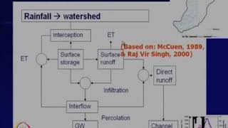
Physically-based distributed models, such as MIKE SHE, SWAT, and TOPMODEL, take a more detailed approach. They integrate comprehensive data concerning land use, topography, climate, and soil characteristics. These models are essential for simulating hydrological processes at a finer spatial scale, allowing for more precise management strategies.
3.6.3 Use of Remote Sensing and GIS
Remote sensing and Geographic Information Systems (GIS) have transformed hydrological modeling over recent years. They enable efficient rainfall estimation through satellite imagery, watershed delineation, and land use classification. These technologies also provide real-time data that are crucial for effective flood and drought monitoring, thus enhancing decision-making in engineering practices.
Youtube Videos


Audio Book
Dive deep into the subject with an immersive audiobook experience.
Empirical and Conceptual Models
Chapter 1 of 3
🔒 Unlock Audio Chapter
Sign up and enroll to access the full audio experience
Chapter Content
• Use of empirical regression models for streamflow prediction.
• Conceptual models like Stanford Watershed Model, NAM model, etc.
Detailed Explanation
This chunk discusses two types of models used in hydrology: empirical and conceptual models. Empirical models are based on observed data and statistical methods, mainly focusing on finding relationships between various factors affecting streamflow. For instance, one might use past rainfall data to predict future streamflow. In contrast, conceptual models like the Stanford Watershed Model and NAM model bring more abstraction—they include simplified representations of physical processes within the watershed, making assumptions and approximations to simulate hydrological behaviors. These models help engineers understand how water moves through landscapes and can be vital in making predictions about water availability and management.
Examples & Analogies
Think of empirical models like teaching a student to predict their grade based on past scores—using real data to anticipate future performance. On the other hand, conceptual models are akin to preparing a student for exams by setting a study strategy based on their learning style, allowing for adjustments based on different scenarios (like varying subjects or topics).
Physically-Based Distributed Models
Chapter 2 of 3
🔒 Unlock Audio Chapter
Sign up and enroll to access the full audio experience
Chapter Content
• Models like MIKE SHE, SWAT, TOPMODEL used for detailed simulation.
• Integration of land use, topography, climate, and soil parameters.
Detailed Explanation
Physically-based distributed models are sophisticated simulation tools that consider various physical processes in the environment to model hydrological phenomena. These models, such as MIKE SHE, SWAT, and TOPMODEL, incorporate numerous inputs including land use, topography, climate factors, and soil characteristics, allowing for a more detailed analysis of how water moves across different landscapes. They provide insights into water quality, flooding, and available water resources by simulating the entire watershed, which can significantly enhance decision-making in water resource management.
Examples & Analogies
Imagine a chef preparing a meal with much consideration given to the exact ingredients and cooking methods used for each recipe. Similarly, these models blend all environmental variables to create a 'recipe' that accurately predicts the hydrological behaviors of a watershed, just as a chef predicts the outcome of a dish based on specific ingredients.
Use of Remote Sensing and GIS
Chapter 3 of 3
🔒 Unlock Audio Chapter
Sign up and enroll to access the full audio experience
Chapter Content
• Rainfall estimation using satellite imagery.
• Watershed delineation and land use classification.
• Real-time flood and drought monitoring systems.
Detailed Explanation
Remote sensing and Geographic Information Systems (GIS) play crucial roles in modern hydrology by allowing engineers and scientists to gather, analyze, and visualize spatial data effectively. Satellite imagery can be used for estimating rainfall across large areas, which is essential for water resource management. Watershed delineation helps in understanding the specific areas contributing to streamflow, and GIS facilitates land use classification. Together, these technologies help in the development of real-time monitoring systems for flooding and drought conditions, providing timely data critical for effective management and response to water-related issues.
Examples & Analogies
Consider how a weather app uses data from satellites to forecast rain for your area. Similarly, remote sensing and GIS offer a comprehensive view of watershed characteristics and conditions, akin to a bird’s-eye view that helps identify which neighborhoods are at risk of flooding, allowing authorities to act proactively.
Key Concepts
-
Empirical Models: Statistical models based on historical data.
-
Conceptual Models: Theoretical models utilizing simplified representations.
-
Physically-Based Models: Detailed models incorporating physical processes and parameters.
-
Remote Sensing: Technology for collecting data from a distance.
-
GIS: Tools for spatial data management and analysis.
Examples & Applications
An example of an empirical model is a regression model predicting streamflow based on rainfall amounts and historic data.
A conceptual model includes the Stanford Watershed Model, which simulates watershed behavior based on physical characteristics.
MIKE SHE model is an example of a physically-based model that accurately predicts surface water interactions.
Memory Aids
Interactive tools to help you remember key concepts
Rhymes
Models built on theories bright, help us see the water's flight.
Stories
Imagine a scientist using a magical lens to see rainfall and land changes from afar; that's like remote sensing aiding hydrology!
Memory Tools
Remember G.R.A.M. – GIS, Remote sensing, Analysis, Modeling; key components in modern hydrology.
Acronyms
C.E.P.
Conceptual models use Concepts
Empirical models use data Predictions.
Flash Cards
Glossary
- Empirical Models
Models that utilize observed data, often based on statistical relationships, to make predictions.
- Conceptual Models
Models that represent hydrological processes based on theoretical frameworks and parameters.
- PhysicallyBased Models
Models that simulate hydrological processes using physical principles and environmental data.
- MIKE SHE
A comprehensive modeling system for simulating surface water and groundwater interactions.
- SWAT
Soil and Water Assessment Tool, a model designed to predict the impact of land management practices on water, sediment, and agricultural chemical yields.
- GIS
Geographic Information System, a framework for gathering, managing, and analyzing spatial and geographical data.
- Remote Sensing
The acquisition of information about an object or area from a distance, typically via satellite or aerial imagery.
Reference links
Supplementary resources to enhance your learning experience.