
Flood Estimation and Management
Enroll to start learning
You’ve not yet enrolled in this course. Please enroll for free to listen to audio lessons, classroom podcasts and take practice test.
Interactive Audio Lesson
Listen to a student-teacher conversation explaining the topic in a relatable way.
Design Flood Estimation
🔒 Unlock Audio Lesson
Sign up and enroll to listen to this audio lesson

Today, we'll discuss how we estimate design floods. This is essential for creating structures like dams and spillways. Can anyone tell me what a design flood is?

Isn't it the maximum expected flood event that can occur in a given period?
Absolutely! We use several methods for this, such as the Unit Hydrograph Method. It's a way to predict how much water will flow into a specific area after rainfall.

What are the other methods?
Great question! We also use the Rational Method and the SCS-CN method. Each method has its specific applications based on urban or rural settings.

How do these methods differ?
The Rational Method is simpler and often used for small urban areas, while the SCS-CN method is useful for larger, rural regions. Remember: R = C * I * A where R is runoff, C is the runoff coefficient, I is rainfall intensity, and A is the area. Can anyone summarize that?

For small areas, it’s the Rational Method, but for larger areas, it’s the SCS-CN method!
Exactly! Well done.
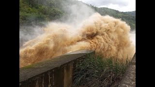
Flood Routing
🔒 Unlock Audio Lesson
Sign up and enroll to listen to this audio lesson

Now, let's move on to flood routing. Why is flood routing important in flood management?
I think it helps in managing how and when floodwater flows through an area.
Exactly! Techniques like the Muskingum Method help us predict floodwater behavior. Can anyone explain what Muskingum involves?
It models the flow of water in channels and how it's affected by storage.
Correct! The Saint-Venant equations are also used for more complex hydraulic routing to estimate peak discharge and attenuation. Let’s do a quick exercise: What do we mean by peak discharge?
It’s the maximum flow rate of water at a given point during a flood event.
Right! Which is key for ensuring structures are not overwhelmed during floods. Great job, everyone!
Floodplain Mapping and Zoning
🔒 Unlock Audio Lesson
Sign up and enroll to listen to this audio lesson
Floodplain mapping is crucial for urban planning. How do we identify flood-prone areas?
Using maps and data, probably with GIS technology?
Exactly! GIS and Remote Sensing help delineate these areas. What do you think zoning involves in this context?
It’s about designating certain areas as safe for building and others as flood-prone, right?
Yes! By applying standards from organizations like FEMA or CWC, we can effectively manage land use and minimize risks. Let's sum it up: what’s the takeaway from today’s discussion?
Zoning and mapping help reduce risks and keep structures safe from floods!
Flood Control Measures
🔒 Unlock Audio Lesson
Sign up and enroll to listen to this audio lesson
Today, we're discussing flood control measures. Can anyone name some types of flood control structures?
Levees and floodwalls?
Correct! What about non-structural options?
Like flood forecasting systems and community preparedness?
Exactly! Combining structural and non-structural measures creates a robust flood management strategy. To help remember this, let’s think of it as two pillars: one for structures and one for strategy. Can someone give me a summary of what we've covered?
Flood control measures include physical structures and community strategies to manage flood risks!
Great summary! Remember, both play a critical role in effective flood management.
Introduction & Overview
Read summaries of the section's main ideas at different levels of detail.
Quick Overview
Standard
The section outlines important techniques for estimating design floods, including the Unit Hydrograph Method and Rational Method, as well as flood routing techniques such as the Muskingum Method. It also discusses floodplain mapping using GIS, zoning applications in urban planning, and various structural and non-structural flood control measures.
Detailed
Flood Estimation and Management
Flood estimation and management are critical components in hydrology that aid in civil engineering projects by predicting and mitigating flood risks. This section presents key techniques for estimating design floods, which are essential for the effective design of hydraulic structures and flood management strategies.
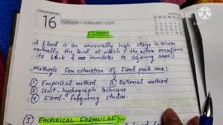
3.2.1 Design Flood Estimation
Methods for estimating design floods include the Unit Hydrograph Method and the Rational Method. The SCS-CN method and the HEC-HMS model are applicable in both urban and rural settings, assisting in calculating runoff and flood potential based on land characteristics and rainfall.
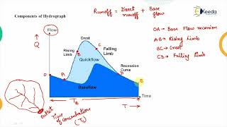
3.2.2 Flood Routing
Flood routing techniques, such as the Muskingum Method and hydraulic routing using the Saint-Venant equations, help engineers predict how floodwaters will travel through channels and reservoirs, estimating peak discharge, attenuation, and lag times.
3.2.3 Floodplain Mapping and Zoning
GIS and Remote Sensing technologies are used to delineate flood-prone areas, which are vital for urban planning and development. Understanding regulatory standards, like those from FEMA or CWC, guides effective zoning practices to minimize flood risk.
3.2.4 Flood Control Measures
Flood control strategies can be categorized into structural measures, such as levees and retention basins, and non-structural measures, including flood forecasting systems and community preparedness strategies. Effective implementation of these measures enhances public safety and infrastructure resilience.
Youtube Videos


Audio Book
Dive deep into the subject with an immersive audiobook experience.
Design Flood Estimation
Chapter 1 of 4
🔒 Unlock Audio Chapter
Sign up and enroll to access the full audio experience
Chapter Content
• Application of Unit Hydrograph Method and Synthetic Hydrographs.
• Use of Rational Method, SCS-CN method, and HEC-HMS in urban and rural settings.
Detailed Explanation
This chunk discusses methods for estimating the design flood, which is crucial for planning flood management strategies. The Unit Hydrograph Method involves analyzing rainfall and converting it into runoff, while Synthetic Hydrographs are used when there is insufficient data for a particular area. The Rational Method is a simple equation used mainly for small urban watersheds, while the SCS-CN method incorporates various land uses and soil types to estimate runoff. HEC-HMS is a more advanced hydrologic model suitable for both urban and rural areas, allowing for complex simulations of rainfall and runoff patterns.
Examples & Analogies
Imagine you're planning a big outdoor event and need to ensure there’s enough space for water if it rains. You might look at past weather patterns to see how much it rained during similar events, using techniques like Unit Hydrograph Method or Synthetic Hydrographs to predict how much rain could create a flood situation, helping you prepare by choosing a location that’s not likely to flood.
Flood Routing
Chapter 2 of 4
🔒 Unlock Audio Chapter
Sign up and enroll to access the full audio experience
Chapter Content
• Hydrologic routing (e.g., Muskingum Method).
• Hydraulic routing using Saint-Venant equations.
• Flood routing through channels and reservoirs to estimate peak attenuation and lag time.
Detailed Explanation
Flood routing is the process of predicting how flood waters move and change over time and space. The Muskingum Method uses a simpler approach based on storage and release relationships to predict flood flow through channels. On the other hand, hydraulic routing, which involves the Saint-Venant equations, is more complex and looks at the physics of fluid flow. This method helps engineers understand how flood peaks are reduced (peak attenuation) and the time it takes for the flood wave to travel downstream (lag time), which is essential for managing floods effectively.
Examples & Analogies
Think of a traffic jam on a highway as a flood of cars. When several lanes merge into one, the number of cars (floodwaters) builds up, and it takes time for them to flow through the bottleneck. By analyzing how traffic flows through different lanes (like the Muskingum and Saint-Venant approaches), we can estimate how long it will take for the cars to clear the jam, similar to estimating how floodwaters will flow through a river or channel.
Floodplain Mapping and Zoning
Chapter 3 of 4
🔒 Unlock Audio Chapter
Sign up and enroll to access the full audio experience
Chapter Content
• GIS and Remote Sensing-based delineation of flood-prone areas.
• Application in urban planning and infrastructure development.
• Use of FEMA (USA) standards or CWC (India) guidelines for zoning.
Detailed Explanation
Floodplain mapping involves identifying areas that are at risk for flooding using Geographic Information Systems (GIS) and Remote Sensing. This data is crucial for urban planners and engineers to design infrastructure that minimizes flood risk. The standards from organizations like FEMA (in the USA) and CWC (in India) serve as guidelines to create zoning laws that dictate what can be built in flood-prone areas, helping to safeguard property and lives.
Examples & Analogies
Imagine a city planner using a detailed map showing areas likely to flood, similar to a weather app predicting storms. By understanding which neighborhoods are safe and which might be at risk, the planner can decide not to place critical infrastructure, like hospitals, in flood-prone areas, much like avoiding parking under a tree during a storm to prevent damage.
Flood Control Measures
Chapter 4 of 4
🔒 Unlock Audio Chapter
Sign up and enroll to access the full audio experience
Chapter Content
• Structural: levees, embankments, retention basins, diversion channels.
• Non-structural: flood forecasting, warning systems, community preparedness.
Detailed Explanation
Flood control measures can be divided into structural techniques, such as building levees and retention basins, which physically alter the environment to prevent flooding, and non-structural methods that focus on preparedness and mitigation, like flood forecasting and community awareness programs. Structural solutions are built to hold back water, while non-structural methods aim to equip individuals and communities with the information and resources needed to respond effectively to flood threats.
Examples & Analogies
Think of flood control like a combination of a dam around a park and a neighborhood watch group for rainstorms. The dam (structural) holds back floodwaters from flooding the park, while the neighborhood watch (non-structural) informs residents about incoming storms and encourages them to take precautions, like moving cars to higher ground.
Key Concepts
-
Design Flood Estimation: Estimating the maximum flood levels using various methods for effective engineering design.
-
Flood Routing: Techniques to predict flood movement through channels and reservoirs to manage peak discharge.
-
Floodplain Mapping: Identifying flood-prone areas through mapping technologies to enhance urban planning.
-
Flood Control Measures: Strategies that mitigate flood risks, including structural and non-structural approaches.
Examples & Applications
An urban project using the SCS-CN method to design an effective drainage system based on land characteristics.
Utilizing the Muskingum Method to determine the peak flood discharge along a river system.
Memory Aids
Interactive tools to help you remember key concepts
Rhymes
Don't let floods surprise, plan with maps and wise, using GIS to see the skies.
Stories
Imagine a town preparing for storms; they use technology to see where rivers form, helping decision-makers keep everyone safe.
Memory Tools
Remember the acronym 'FRT' for Flood Routing Techniques: F for Floodplain, R for Routing, T for Technology.
Acronyms
Remember HUDS for flood estimation
for Hydrograph
for Urban settings
for Design flood
for Synthetic Hydrographs.
Flash Cards
Glossary
- Unit Hydrograph Method
A method for predicting streamflow from rainfall data with a focus on time and volume.
- Rational Method
A simplified approach for estimating peak discharge based on area and rainfall intensity.
- SCSCN Method
A method that uses a curve number to quantify runoff from rainfall based on land use and hydrologic soil type.
- Muskingum Method
A flood routing method that models the storage and routing of water in a river channel.
- GIS
Geographic Information System, a tool for mapping and analyzing spatial data.
- Floodplain Mapping
The process of delineating areas that are subject to flooding.
- Levees
Embankments built to prevent floodwaters from entering protected areas.
- Nonstructural Measures
Strategies or actions that do not involve physical structures, such as community preparedness.
Reference links
Supplementary resources to enhance your learning experience.